
Oceansat-2
Encyclopedia
Oceansat-2 is an Indian satellite designed to provide service continuity for operational users of the Ocean Colour Monitor (OCM)instrument on Oceansat-1. It will also enhance the potential of applications in other areas. The main objectives of OceanSat-2 are to study surface winds and ocean surface strata, observation of chlorophyll
concentrations, monitoring of phytoplankton
blooms, study of atmospheric aerosol
s and suspended sediments in the water.
Oceansat-2 is ISRO’s second in the series of Indian Remote Sensing satellites dedicated to ocean research, and will provide continuity to the applications of Oceansat-1 (launched in 1999). Oceansat-2 will carry three payloads including an Ocean Colour Monitor (OCM-2), similar to the device carried on Oceansat-1. Data from all instruments will be made available to the global scientific community after the post-launch sensor characterization, which is expected to be completed within 6 months of the launch. Oceansat-2 was launched from SDSC (SHAR) on 23 September 2009 using PSLV-C14
.
concentrations, monitoring of phytoplankton blooms, study of atmospheric aerosol
s and suspended sediments in the water.
Oceansat-2 will carry two payloads for ocean related studies, namely, Ocean Colour Monitor (OCM) and Ku-band Pencil Beam Scatterometer
. An additional piggy-back payload called ROSA (Radio Occultation Sounder for Atmospheric studies) developed by the Italian Space Agency
(ASI) is also proposed to be included. The major applications of data from Oceansat-2 are identification of potential fishing zones, sea state forecasting, coastal zone studies and inputs for weather forecasting
and climatic studies.
In copybook style, the rocket first flung out Oceansat-2 at an altitude of 720 km above the earth in a sun-synchronous orbit (SSO), followed by the four nano satellites - also called Cubesats, each weighing one kg. The remaining two, each weighing eight kg, were attached to the rocket's fourth stage. Of the six nano satellites, four are from Germany, one is from Switzerland and one from Turkey. The seventh is a big one, India's Oceansat-2 weighing 960 kg. Soon after the satellites were put into orbit, Indian Space Research Organisation's (ISRO) satellite tracking centres started monitoring them.
Seven satellites in 1,200 seconds. The launch is similar to the one in April 2008 when ISRO launched 10 satellites.
The sequence of ejection is very similar to the April 2008 launch featuring one big satellite - Cartosat-2A and nine other nano satellites - 10 in all: once the PSLV takes off and reaches a certain height and velocity, it will first launch the Oceansat-2 and a few seconds later, the first of four nano satellites. Every 10–12 seconds, the PSLV will launch four satellites one after the other. (Two will remain with the fourth stage).
"The rocket re-orients itself every time a satellite is to be placed in orbit. The re-orientation ensures one satellite doesn't collide with another. The rocket effectively re-orients itself four to five times in the space of one flight," a scientist explained.
The brain of the rocket would have made all calculations in advance - from ejection of first satellite to the fifth. The exact moment of ejection and then re-orientation for the next ejection is worked out in advance. All mathematical calculations on the ground, launch sequence and flight path have to work to zero error. Oceansat-2, India's second satellite to study oceans as well as interaction of oceans and atmosphere, is the 16th remote sensing satellite of India. It is in the shape of a cuboid with two solar panels projecting from its sides. The satellite will map fishing zones around India, measure ocean surface windspeeds as well as atmospheric temperature and humidity.
This was the 16th PSLV's mission. From September 1993 to April 2009, PSLV has been launched 15 times. Fourteen launches have been successful continuously while only one has failed so far.
During 2007, the flight model OCM payload electronics was realised, the camera assembly was in progress and scatterometer configuration was finalised. Fabrication of mainframe systems like Core power, RF systems BMU, and sensors had started and DC-DC converters for OCM, earth sensor, TME realized.
As of 2008, mainframe structure had been realised. Preliminary design review of all mainframe systems completed. OCM camera test and evaluation had been completed. Scatterometer qualification model hardware had been realized. ROSA interfaces with spacecraft systems had been finalised. Qualification model of scatterometer scan mechanism and the interface test with electronics had also been completed.
Chlorophyll
Chlorophyll is a green pigment found in almost all plants, algae, and cyanobacteria. Its name is derived from the Greek words χλωρος, chloros and φύλλον, phyllon . Chlorophyll is an extremely important biomolecule, critical in photosynthesis, which allows plants to obtain energy from light...
concentrations, monitoring of phytoplankton
Phytoplankton
Phytoplankton are the autotrophic component of the plankton community. The name comes from the Greek words φυτόν , meaning "plant", and πλαγκτός , meaning "wanderer" or "drifter". Most phytoplankton are too small to be individually seen with the unaided eye...
blooms, study of atmospheric aerosol
Aerosol
Technically, an aerosol is a suspension of fine solid particles or liquid droplets in a gas. Examples are clouds, and air pollution such as smog and smoke. In general conversation, aerosol usually refers to an aerosol spray can or the output of such a can...
s and suspended sediments in the water.
Oceansat-2 is ISRO’s second in the series of Indian Remote Sensing satellites dedicated to ocean research, and will provide continuity to the applications of Oceansat-1 (launched in 1999). Oceansat-2 will carry three payloads including an Ocean Colour Monitor (OCM-2), similar to the device carried on Oceansat-1. Data from all instruments will be made available to the global scientific community after the post-launch sensor characterization, which is expected to be completed within 6 months of the launch. Oceansat-2 was launched from SDSC (SHAR) on 23 September 2009 using PSLV-C14
Polar Satellite Launch Vehicle
The Polar Satellite Launch Vehicle , commonly known by its abbreviation PSLV, is an expendable launch system developed and operated by the Indian Space Research Organisation . It was developed to allow India to launch its Indian Remote Sensing satellites into sun synchronous orbits, a service that...
.
Mission
The mission objectives of Oceansat-2 are to gather systematic data for oceanographic, coastal and atmospheric applications. The main objectives of OceanSat-2 are to study surface winds and ocean surface strata, observation of chlorophyllChlorophyll
Chlorophyll is a green pigment found in almost all plants, algae, and cyanobacteria. Its name is derived from the Greek words χλωρος, chloros and φύλλον, phyllon . Chlorophyll is an extremely important biomolecule, critical in photosynthesis, which allows plants to obtain energy from light...
concentrations, monitoring of phytoplankton blooms, study of atmospheric aerosol
Aerosol
Technically, an aerosol is a suspension of fine solid particles or liquid droplets in a gas. Examples are clouds, and air pollution such as smog and smoke. In general conversation, aerosol usually refers to an aerosol spray can or the output of such a can...
s and suspended sediments in the water.
Oceansat-2 will carry two payloads for ocean related studies, namely, Ocean Colour Monitor (OCM) and Ku-band Pencil Beam Scatterometer
Scatterometer
A radar scatterometer is designed to determine the normalized radar cross section of the surface. Scatterometers operate by transmitting a pulse of microwave energy towards the Earth's surface and measuring the reflected energy. A separate measurement of the noise-only power is made and...
. An additional piggy-back payload called ROSA (Radio Occultation Sounder for Atmospheric studies) developed by the Italian Space Agency
Italian Space Agency
The Italian Space Agency is a government agency established in 1988 to fund, regulate and coordinate space exploration activities in Italy...
(ASI) is also proposed to be included. The major applications of data from Oceansat-2 are identification of potential fishing zones, sea state forecasting, coastal zone studies and inputs for weather forecasting
Weather forecasting
Weather forecasting is the application of science and technology to predict the state of the atmosphere for a given location. Human beings have attempted to predict the weather informally for millennia, and formally since the nineteenth century...
and climatic studies.
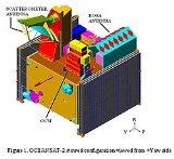
Payload
The scientific payload contains three instruments. Two are Indian and one is from the Italian Space Agency.- Ocean Colour Monitor (OCM) - OCM is a 8-band multi-spectral camera operating in the Visible – Near IR spectral range. This camera provides an instantaneous geometric field of view of 360 meter and a swath of 1420 km. OCM can be tilted up to + 20 degree along track.
- Scanning Scatterometer (SCAT) - SCAT is an active microwave device designed and developed at ISRO/SAC, Ahmedabad. It will be used to determine ocean surface level wind vectors through estimation of radar backscatterBackscatterIn physics, backscatter is the reflection of waves, particles, or signals back to the direction they came from. It is a diffuse reflection due to scattering, as opposed to specular reflection like a mirror...
. The scatterometer system has a 1-m parabolic dish antenna and a dual feed assembly to generate two pencil beams and is scanned at a rate of 20.5 rpm to cover the entire swath. The Ku-band pencil beamPencil beamIn optics, a pencil or pencil of rays is a geometric construct used to describe a beam or portion of a beam of electromagnetic radiation or charged particles, typically in the form of a narrow cone or cylinder....
scatterometer is an active microwave radar operating at 13.515 GHz providing a ground resolution cell of size 50 x 50 km. It consists of a parabolic dish antenna of 1 meter diameter which is offset mounted with a cant angle of about 46 degree with respect to earth viewing axis. This antenna is continuously rotated at 20.5 rpm using a scan mechanism with the scan axis along the +ve Yaw axis. By using two offset feeds at the focal plane of the antenna, two beams are generated which will conically scan the ground surface. The back scattered power in each beam from the ocean surface is measured to derive wind vector. It is an improved version of the one on Oceansat-1.. The inner beam makes an incidence angle of 48.90° and the outer beam makes an incidence angle of 57.60° on the ground. It covers a continuous swath of 1400 km for inner beam and 1840 km for outer beam respectively. The inner and outer beams are configured in horizontal and vertical polarization respectively for both transmit and receive modes. The aim is to provide global ocean coverage and wind vector retrieval with a revisit time of 2 days.
- Radio Occultation Sounder for Atmospheric Studies (ROSA) - ROSA is a new GPS occultation receiver provided by ASI (Italian Space AgencyItalian Space AgencyThe Italian Space Agency is a government agency established in 1988 to fund, regulate and coordinate space exploration activities in Italy...
). The objective is to characterize the lower atmosphere and the ionosphere, opening the possibilities for the development of several scientific activities exploiting these new radio occultation data sets.
Current status
India successfully launched its 16th remote-sensing satellite Oceansat-2 and six nano European satellites in 1,200 seconds with the help The Ocean Monitoring Satellite Oceansat-2 is seen 18 minutes after blast off in Sriharikota, AP. of Polar Satellite Launch Vehicle (PSLV- C-14) from Sriharikota on 23 September, 2009. The launch was carried out as per schedule at 11.51 am and ended at 12.06 pm. The 44.4-metre tall, 230-tonne Indian rocket Polar Satellite Launch Vehicle (PSLV) freed itself from the launch pad at the spaceport and lifted itself up, lugging the 960-kg Oceansat-2 and the six nano satellites all together weighing 20 kg.In copybook style, the rocket first flung out Oceansat-2 at an altitude of 720 km above the earth in a sun-synchronous orbit (SSO), followed by the four nano satellites - also called Cubesats, each weighing one kg. The remaining two, each weighing eight kg, were attached to the rocket's fourth stage. Of the six nano satellites, four are from Germany, one is from Switzerland and one from Turkey. The seventh is a big one, India's Oceansat-2 weighing 960 kg. Soon after the satellites were put into orbit, Indian Space Research Organisation's (ISRO) satellite tracking centres started monitoring them.
Seven satellites in 1,200 seconds. The launch is similar to the one in April 2008 when ISRO launched 10 satellites.
The sequence of ejection is very similar to the April 2008 launch featuring one big satellite - Cartosat-2A and nine other nano satellites - 10 in all: once the PSLV takes off and reaches a certain height and velocity, it will first launch the Oceansat-2 and a few seconds later, the first of four nano satellites. Every 10–12 seconds, the PSLV will launch four satellites one after the other. (Two will remain with the fourth stage).
"The rocket re-orients itself every time a satellite is to be placed in orbit. The re-orientation ensures one satellite doesn't collide with another. The rocket effectively re-orients itself four to five times in the space of one flight," a scientist explained.
The brain of the rocket would have made all calculations in advance - from ejection of first satellite to the fifth. The exact moment of ejection and then re-orientation for the next ejection is worked out in advance. All mathematical calculations on the ground, launch sequence and flight path have to work to zero error. Oceansat-2, India's second satellite to study oceans as well as interaction of oceans and atmosphere, is the 16th remote sensing satellite of India. It is in the shape of a cuboid with two solar panels projecting from its sides. The satellite will map fishing zones around India, measure ocean surface windspeeds as well as atmospheric temperature and humidity.
This was the 16th PSLV's mission. From September 1993 to April 2009, PSLV has been launched 15 times. Fourteen launches have been successful continuously while only one has failed so far.
During 2007, the flight model OCM payload electronics was realised, the camera assembly was in progress and scatterometer configuration was finalised. Fabrication of mainframe systems like Core power, RF systems BMU, and sensors had started and DC-DC converters for OCM, earth sensor, TME realized.
As of 2008, mainframe structure had been realised. Preliminary design review of all mainframe systems completed. OCM camera test and evaluation had been completed. Scatterometer qualification model hardware had been realized. ROSA interfaces with spacecraft systems had been finalised. Qualification model of scatterometer scan mechanism and the interface test with electronics had also been completed.
See also
- Indian Remote Sensing satelliteIndian Remote Sensing satelliteIndian Remote Sensing satellites are a series of Earth Observation satellites, built, launched and maintained by Indian Space Research Organisation...
- List of Indian satellites
- OceanographyOceanographyOceanography , also called oceanology or marine science, is the branch of Earth science that studies the ocean...
- ScatterometerScatterometerA radar scatterometer is designed to determine the normalized radar cross section of the surface. Scatterometers operate by transmitting a pulse of microwave energy towards the Earth's surface and measuring the reflected energy. A separate measurement of the noise-only power is made and...