

Nova Scotia Route 321
Encyclopedia
Canada
Canada is a North American country consisting of ten provinces and three territories. Located in the northern part of the continent, it extends from the Atlantic Ocean in the east to the Pacific Ocean in the west, and northward into the Arctic Ocean...
province of Nova Scotia
Nova Scotia
Nova Scotia is one of Canada's three Maritime provinces and is the most populous province in Atlantic Canada. The name of the province is Latin for "New Scotland," but "Nova Scotia" is the recognized, English-language name of the province. The provincial capital is Halifax. Nova Scotia is the...
.
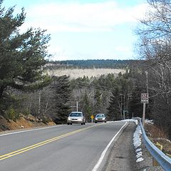
It is located in Cumberland County
Cumberland County, Nova Scotia
Cumberland County is a county in the Canadian province of Nova Scotia.-History:The name Cumberland was applied by Lieutenant-Colonel Robert Monckton to the captured Fort Beauséjour on June 18, 1755 in honour of the third son of King George II, William Augustus, Duke of Cumberland, victor at...
and connects Springhill
Springhill, Nova Scotia
-Coal mining:The first industrial coal mining in the area took place in the 1870s after a rail connection was built by the Springhill and Parrsboro Coal and Railway Company to the newly completed Intercolonial Railway at neighbouring Springhill Junction....
at Route 2
Nova Scotia Route 2
Trunk 2 is part of the Canadian province of Nova Scotia's system of Trunk Highways. The route runs from Halifax to Fort Lawrence on the New Brunswick border. Until the 1960s, Trunk 2 was the Halifax area's most important highway link to other provinces, and was part of a longer Trunk 2 which ended...
with Port Howe
Port Howe, Nova Scotia
Port Howe is a community in the Canadian province of Nova Scotia, located in Cumberland County .-References:*...
at Trunk 6.
From Port Howe
Port Howe, Nova Scotia
Port Howe is a community in the Canadian province of Nova Scotia, located in Cumberland County .-References:*...
it travels southward following the eastern banks of River Philip
River Philip
The River Philip is a river contained entirely within Cumberland County, Nova Scotia, Canada....
to the town of Oxford
Oxford, Nova Scotia
Oxford is a town in Cumberland County, Nova Scotia, Canada east of Amherst. The town is directly serviced by Routes 104, 204, 301, and 321.-History:...
. For the first while in the town it is known as Pugwash Road. It then turns to the west and is known as Water Street. Most of Water Street is also Route 204
Nova Scotia Route 204
Route 204 is a collector road in the Canadian province of Nova Scotia.It is located in Cumberland County and runs from Amherst at Trunk 6 to Streets Ridge at Route 368.-Route description:...
. Near the centre of Oxford the route turns southward and is known as Main Street where it has an interchange with Highway 104
Nova Scotia Highway 104
Highway 104 in Nova Scotia runs from the New Brunswick border near Amherst to St. Peter's. Except for the portion on Cape Breton Island between Port Hawkesbury and St. Peter's, it is part of the Trans-Canada Highway....
(Trans Canada Highway). From there it travels southward to River Philip
River Philip, Nova Scotia
River Philip is a Canadian rural community in Cumberland County, Nova Scotia. The centre of the community is located near the intersection of Route 321 and Wyvern Road.It is situated in a small valley formed by the River Philip, from which it derives its name....
where it turns westward and heads to Trunk 2
Nova Scotia Route 2
Trunk 2 is part of the Canadian province of Nova Scotia's system of Trunk Highways. The route runs from Halifax to Fort Lawrence on the New Brunswick border. Until the 1960s, Trunk 2 was the Halifax area's most important highway link to other provinces, and was part of a longer Trunk 2 which ended...
in Springhill and is known locally as Main Street.
Communities
- SpringhillSpringhill, Nova Scotia-Coal mining:The first industrial coal mining in the area took place in the 1870s after a rail connection was built by the Springhill and Parrsboro Coal and Railway Company to the newly completed Intercolonial Railway at neighbouring Springhill Junction....
(known as Main Street) - Salt Springs
- Valley Road
- River PhilipRiver Philip, Nova ScotiaRiver Philip is a Canadian rural community in Cumberland County, Nova Scotia. The centre of the community is located near the intersection of Route 321 and Wyvern Road.It is situated in a small valley formed by the River Philip, from which it derives its name....
- OxfordOxford, Nova ScotiaOxford is a town in Cumberland County, Nova Scotia, Canada east of Amherst. The town is directly serviced by Routes 104, 204, 301, and 321.-History:...
(known as Water Street, Main Street and Upper Main Street) - KolbecKolbec, Nova ScotiaKolbec is a community in the Canadian province of Nova Scotia, located in Cumberland County . Most of the community lies on Route 301.The community lies on the western bank of River Philip and has a cemetery within its boundaries.-References:*...
- Riverview
- Port HowePort Howe, Nova ScotiaPort Howe is a community in the Canadian province of Nova Scotia, located in Cumberland County .-References:*...
Major intersections
Major Intersections/Junctions in order from Port Howe to Springhill.- Murray Road
- Hansford Siding Road
- Hansford Road
- Water Street, Oxford
- Birchwood Road, Oxford (Route 204Nova Scotia Route 204Route 204 is a collector road in the Canadian province of Nova Scotia.It is located in Cumberland County and runs from Amherst at Trunk 6 to Streets Ridge at Route 368.-Route description:...
) - Upper/Lower Main Street, Oxford (Route 301Nova Scotia Route 301Route 301 is a collector road in the Canadian province of Nova Scotia.It is located in Cumberland County and connects Oxford at Route 204 with Port Howe at Trunk 6.From Port Howe it follows the western bank of River Philip to Oxford town limits...
, and Route 204Nova Scotia Route 204Route 204 is a collector road in the Canadian province of Nova Scotia.It is located in Cumberland County and runs from Amherst at Trunk 6 to Streets Ridge at Route 368.-Route description:...
) - Black River Road, Oxford
- Highway 104Nova Scotia Highway 104Highway 104 in Nova Scotia runs from the New Brunswick border near Amherst to St. Peter's. Except for the portion on Cape Breton Island between Port Hawkesbury and St. Peter's, it is part of the Trans-Canada Highway....
Exit 6 (Trans Canada Highway). - Wyvern Road
- Junction Road, Springhill (Route 2Nova Scotia Route 2Trunk 2 is part of the Canadian province of Nova Scotia's system of Trunk Highways. The route runs from Halifax to Fort Lawrence on the New Brunswick border. Until the 1960s, Trunk 2 was the Halifax area's most important highway link to other provinces, and was part of a longer Trunk 2 which ended...
)