
Nosegawa, Nara
Encyclopedia
is a village
located in Yoshino District
, Nara
, Japan
.
As of October 1, 2007, the village has an estimated population
of 699. The total area is 155.03 km².
, it is surrounded by the Kii Mountain Range. Mount Natsumushi (1349m) and Mount Arakami (1260m) are two major mountains in Nosegawa. Many rivers, such as the Iketsu River, run through the village and are eventually united by the Totsukawa River which flows to the Pacific Ocean
.
Villages of Japan
A is a local administrative unit in Japan.It is a local public body along with , , and . Geographically, a village's extent is contained within a prefecture....
located in Yoshino District
Yoshino District, Nara
Yoshino is a district located in Nara Prefecture, Japan.As of 2003, the district has an estimated population of 59,020 and a density of 26.14 persons per km²...
, Nara
Nara Prefecture
is a prefecture in the Kansai region on Honshū Island, Japan. The capital is the city of Nara.-History:The present-day Nara Prefecture was created in 1887, making it independent of Osaka Prefecture....
, Japan
Japan
Japan is an island nation in East Asia. Located in the Pacific Ocean, it lies to the east of the Sea of Japan, China, North Korea, South Korea and Russia, stretching from the Sea of Okhotsk in the north to the East China Sea and Taiwan in the south...
.
As of October 1, 2007, the village has an estimated population
Population
A population is all the organisms that both belong to the same group or species and live in the same geographical area. The area that is used to define a sexual population is such that inter-breeding is possible between any pair within the area and more probable than cross-breeding with individuals...
of 699. The total area is 155.03 km².
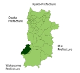
Geography
Located in southwestern portion of Nara PrefectureNara Prefecture
is a prefecture in the Kansai region on Honshū Island, Japan. The capital is the city of Nara.-History:The present-day Nara Prefecture was created in 1887, making it independent of Osaka Prefecture....
, it is surrounded by the Kii Mountain Range. Mount Natsumushi (1349m) and Mount Arakami (1260m) are two major mountains in Nosegawa. Many rivers, such as the Iketsu River, run through the village and are eventually united by the Totsukawa River which flows to the Pacific Ocean
Pacific Ocean
The Pacific Ocean is the largest of the Earth's oceanic divisions. It extends from the Arctic in the north to the Southern Ocean in the south, bounded by Asia and Australia in the west, and the Americas in the east.At 165.2 million square kilometres in area, this largest division of the World...
.
Surrounding municipalities
- Nara PrefectureNara Prefectureis a prefecture in the Kansai region on Honshū Island, Japan. The capital is the city of Nara.-History:The present-day Nara Prefecture was created in 1887, making it independent of Osaka Prefecture....
- GojōGojo, Narais a city located in Nara Prefecture, Japan.As of May 31, 2011, the city has an estimated population of 35,380 wit 13,864 households and the density of 121.17 persons per km²...
- TotsukawaTotsukawa, Narais a village located in the Yoshino District of Nara Prefecture, Japan. It's recognized as the largest village in Japan in terms of land area.As of 2009, the village has an estimated population of 4,029 and a density of 5.99 persons per km². The total area is 672.35 km².-History:In 1889, a...
- Gojō
- Wakayama PrefectureWakayama Prefectureis a prefecture of Japan located on the Kii Peninsula in the Kansai region on Honshū island. The capital is the city of Wakayama.- History :Present-day Wakayama is mostly the western part of the province of Kii.- 1953 Wakayama Prefecture flood disaster :...
- KōyaKoya, Wakayamais a town located on a plateau atop Mt. Koya in Ito District, Wakayama, Japan. The town is known as the headquarters of the Shingon sect of Japanese Buddhism....
- TanabeTanabe, Wakayamais the second biggest city in Wakayama Prefecture, Japan.As of 2008 , the city has an estimated population of 80,398 and a density of 78.3 persons per km². The total area is 1026.77 km². The city was founded on May 20, 1942.Tanabe is on the coast and surrounded by mountains...
- KatsuragiKatsuragi, Wakayamais a town located in Ito District, Wakayama, Japan.As of September 30, 2010, the town has an estimated population of 18,948 and a density of 124.88 persons per km². The total area is 151.73 km²....
- AridagawaAridagawa, Wakayama-External links:*...
- Kōya
Education
- Primary Schools
- Nosegawa Elementary School
- Junior High Schools
- Nosegawa Junior High School