
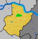
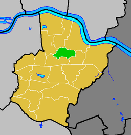
Northumberland Heath
Encyclopedia
Wards of the United Kingdom
A ward in the United Kingdom is an electoral district at sub-national level represented by one or more councillors. It is the primary unit of British administrative and electoral geography .-England:...
within the London Borough of Bexley
London Borough of Bexley
The London Borough of Bexley lies in south east Greater London, and is a borough referred to as part of Outer London. It has common borders with the London Borough of Bromley to the south, the London Borough of Greenwich to the west, across the River Thames to the north it borders the London...
, south east London
London
London is the capital city of :England and the :United Kingdom, the largest metropolitan area in the United Kingdom, and the largest urban zone in the European Union by most measures. Located on the River Thames, London has been a major settlement for two millennia, its history going back to its...
, England. Northumberland Heath is often referred to locally as "North' Heath" and is often considered to be part of upper Erith
Erith
Erith is a district of southeast London on the River Thames. Erith's town centre has undergone a series of modernisations since 1961.-Pre-medieval:...
.
History
The area was once known as Spike Island after the workhouse that was situated there. The area is mainly residential although there is a large industrial bakery in Belmont Road. Much of the housing stock is VictorianVictorian architecture
The term Victorian architecture refers collectively to several architectural styles employed predominantly during the middle and late 19th century. The period that it indicates may slightly overlap the actual reign, 20 June 1837 – 22 January 1901, of Queen Victoria. This represents the British and...
with some 1940's council developments and a Cottage estate built for local Vickers armaments workers in 1916. Nearest Railway stations are Erith
Erith railway station
Erith station serves Erith in the London Borough of Bexley, southeast London.The station stands between Belvedere and Slade Green on the North Kent line...
and Barnehurst
Barnehurst railway station
Barnehurst railway station serves Barnehurst, London Borough of Bexley: it is 13.9 miles from Central London on the Bexleyheath Line...
. There is a large Catholic
Catholic
The word catholic comes from the Greek phrase , meaning "on the whole," "according to the whole" or "in general", and is a combination of the Greek words meaning "about" and meaning "whole"...
church in Bexley Road (Our Lady of the Angels) with a friary attached, and a Church of England (St Paul's) in Mill Road. A conservation area on Brook Street safeguards some terraces that represent early examples of municipal housing.
Politics
Most of Northumberland Heath is within Northumberland Heath ward (local Councillors are Helen Fuller, Peter Reader and Alex Sawyer - all Conservative), whilst other parts are within Colyers wardColyers ward
Colyers is an electoral ward in the London Borough of Bexley. It consists of parts of Barnehurst, Erith and Northumberland Heath. Ward Councillors are Brian Bishop, Maxine Fothergill and Chris Taylor ....
.
Education
- For education in Northumberland Heath see the main London Borough of Bexley article
Nearest places
- ErithErithErith is a district of southeast London on the River Thames. Erith's town centre has undergone a series of modernisations since 1961.-Pre-medieval:...
- BelvedereBelvedere, LondonBelvedere is a suburban and largely working class area and electoral ward in the London Borough of Bexley in Southeast London.-History:The area which is today known as Belvedere was originally part of Lesness Heath, which originally stretched from the area of Lesnes Abbey to Erith and constituted...
- Slade GreenSlade GreenSlade Green is a place in south- east London closer to the edge of London located in the London Borough of Bexley. It is a suburban development situated east-southeast of Charing Cross and lying south of the River Thames slightly to the west of the River Darenth and River Cray.-History and...
- BexleyheathBexleyheathBexleyheath is a main suburban district of Southeast London, England, in the London Borough of Bexley with a small percentage of the district itself being in the London Borough of Greenwich. Bexleyheath is located on the border of Inner London and Outer London. It is east south-east of Charing Cross...
- BarnehurstBarnehurstBarnehurst is a town and electoral ward in the London Borough of Bexley, England. It is a suburban development in Southeast London located 12.5 miles east south-east of Charing Cross.-History:...
Places of Worship
Northumberland Heath Baptist ChurchSt Paul's Church Mill Road
Rail
The nearest stations are at Slade Green and Erith on the Woolwich line and Barnehurst on the Bexleyheath line. Trains run between London Charing Cross, or London Cannon Street and Dartford railway stationDartford railway station
Dartford railway station serves the town of Dartford in Kent, England. All train services from the station are operated by Southeastern, which also manages the station...
. On the Bexleyheath line there is also a 6-day train service to London Victoria.
Buses
The 89 bus contracted by TfLTransport for London
Transport for London is the local government body responsible for most aspects of the transport system in Greater London in England. Its role is to implement the transport strategy and to manage transport services across London...
runs between Lewisham
Lewisham
Lewisham is a district in South London, England, located in the London Borough of Lewisham. It is situated south-east of Charing Cross. The area is identified in the London Plan as one of 35 major centres in Greater London.-History:...
Station and Slade Green Station; The 89 has a frequency of 10 minutes Monday to Saturday daytime and, in the evenings and on Sundays, a frequency of 20 minutes. In the early mornings a night bus service operates called the N89 which runs between Trafalgar Square
Trafalgar Square
Trafalgar Square is a public space and tourist attraction in central London, England, United Kingdom. At its centre is Nelson's Column, which is guarded by four lion statues at its base. There are a number of statues and sculptures in the square, with one plinth displaying changing pieces of...
and Erith; The N89 operates to a frequency of every 30 minutes.
The 229 bus contracted by TfL runs between Queen Mary's hospital Sidcup
Sidcup
Sidcup is a district in South East London in the London Borough of Bexley and small parts of the district in the London Borough of Greenwich.Located south east of Charing Cross, Sidcup is bordered by the London Boroughs of Greenwich and Bromley and Kent County Council, and whilst now part of...
and Thamesmead
Thamesmead
Thamesmead is a district of south-east London, England, located in the London Boroughs of Greenwich and Bexley. It is situated east of Charing Cross....
Town Centre; The 229 has a frequency of 10 minutes Monday to Saturday daytime, and in the evenings and on Sundays a frequency of 15 minutes.
The smaller B12 bus contracted by TfL runs between Erith and Joydens Wood
Joydens Wood
Joyden's Wood is one of over 1,000 woodlands in the UK looked after by the Woodland Trust. The first records of a wood on this site go back to 1600 AD making it an Ancient Woodland site.-Location:...
via Bexleyheath Station and the shopping centres of Bexleyheath and Bexley village. The B12 has a daytime frequency of 20 minutes Monday to Saturday daytime, and in the evenings a frequency of 30 minutes. This bus does not run on Sundays.