
Northern Rockies Regional District, British Columbia
Encyclopedia
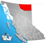
The Northern Rockies Regional Municipality, formerly the Northern Rockies Regional District, and before that the Fort Nelson-Liard Regional District, is a regional municipality
in northeastern British Columbia
, Canada
. The regional district offices are located in the town of Fort Nelson
, which is the only municipality of the district. The town comprises over 73 percent of the district's population of 6,147 (2006 census
). The Regional Board consists of three rural directors and all four town councillors with the mayor of Fort Nelson acting as the Regional Chairman. The staff holds dual functions as employees of the regional district and the town of Fort Nelson.
The NRRD lies on the east slope of the Rocky Mountains
, and comprises approximately 9.2% of the total area of the province of British Columbia, encompassing 85151.45 square kilometres (32,877.2 sq mi). Its southern boundary is the 58th Parallel of latitude.The Alaska Highway
divides the district from southeast-to-northwest. The district is mostly made up of remote mountainous and forest areas, and includes thousands of rivers and streams, hundreds of lakes, an abundance of wildlife, and spectacular scenery.
The Northern Rockies Regional District was created in 1987 when the Peace River-Liard Regional District was divided along the 58th parallel into the Peace River Regional District and the Fort Nelson - Liard Regional District (later re-named the Northern Rockies Regional District).
. Electoral areas are only relevant in the selection of the municipality's council, they are not used for administrative purposes; further, residents of Indian Reserves in these areas do not vote and are not part of municipal governance.
and Toad River
. Residents of the Indian Reserves at those locations do not take part in municipal elections and their governments are separate from that of the regional municipality.
Regional municipality
A regional municipality is a type of Canadian municipal government similar to and at the same municipal government level as a county, although the specific structure and servicing responsibilities may vary from place to place...
in northeastern British Columbia
British Columbia
British Columbia is the westernmost of Canada's provinces and is known for its natural beauty, as reflected in its Latin motto, Splendor sine occasu . Its name was chosen by Queen Victoria in 1858...
, Canada
Canada
Canada is a North American country consisting of ten provinces and three territories. Located in the northern part of the continent, it extends from the Atlantic Ocean in the east to the Pacific Ocean in the west, and northward into the Arctic Ocean...
. The regional district offices are located in the town of Fort Nelson
Fort Nelson, British Columbia
Fort Nelson is a town of approximately 5000 residents in British Columbia's northeastern corner. It is the administrative centre of the newly formed Northern Rockies Regional Municipality, a first for BC. The majority of Fort Nelson's economic activities have historically been concentrated in the...
, which is the only municipality of the district. The town comprises over 73 percent of the district's population of 6,147 (2006 census
Canada 2006 Census
The Canada 2006 Census was a detailed enumeration of the Canadian population. Census day was May 16, 2006. The next census following will be the 2011 Census. Canada's total population enumerated by the 2006 census was 31,612,897...
). The Regional Board consists of three rural directors and all four town councillors with the mayor of Fort Nelson acting as the Regional Chairman. The staff holds dual functions as employees of the regional district and the town of Fort Nelson.
The NRRD lies on the east slope of the Rocky Mountains
Rocky Mountains
The Rocky Mountains are a major mountain range in western North America. The Rocky Mountains stretch more than from the northernmost part of British Columbia, in western Canada, to New Mexico, in the southwestern United States...
, and comprises approximately 9.2% of the total area of the province of British Columbia, encompassing 85151.45 square kilometres (32,877.2 sq mi). Its southern boundary is the 58th Parallel of latitude.The Alaska Highway
Alaska Highway
The Alaska Highway was constructed during World War II for the purpose of connecting the contiguous U.S. to Alaska through Canada. It begins at the junction with several Canadian highways in Dawson Creek, British Columbia and runs to Delta Junction, Alaska, via Whitehorse, Yukon...
divides the district from southeast-to-northwest. The district is mostly made up of remote mountainous and forest areas, and includes thousands of rivers and streams, hundreds of lakes, an abundance of wildlife, and spectacular scenery.
The Northern Rockies Regional District was created in 1987 when the Peace River-Liard Regional District was divided along the 58th parallel into the Peace River Regional District and the Fort Nelson - Liard Regional District (later re-named the Northern Rockies Regional District).
Electoral areas
The regional district has only two electoral areas, divided by the 124th Line of Longitude, which is intersected by the Liard River at the confluence of the Beaver RiverBeaver River (Liard)
The Beaver River is a tributary of the Liard River, entering that stream in the area of its Grand Canyon just south of the British Columbia-Yukon border after running generally south-east from its origin in the extreme southeast corner of the Yukon Territory.-Tributaries:Tributaries of the Beaver...
. Electoral areas are only relevant in the selection of the municipality's council, they are not used for administrative purposes; further, residents of Indian Reserves in these areas do not vote and are not part of municipal governance.
Northern Rockies A, British Columbia
Area A comprises the eastern half of the regional district.Northern Rockies B, British Columbia
Area B comprises the western half, roughly, of the regional municipality and includes the communities of Liard RiverLiard River, British Columbia
Liard River is a small community in northern British Columbia, Canada. It has a population of about 100 people. It is located at Kilometre 799 of the Alaska Highway, near the border of British Columbia and the Yukon Territory....
and Toad River
Toad River, British Columbia
Toad River, originally Toad's River Post, is a highway service community in northern British Columbia, Canada, located at historic Mile 422 on Highway 97, the Alaska Highway, near the confluence of the Toad and Racing Rivers...
. Residents of the Indian Reserves at those locations do not take part in municipal elections and their governments are separate from that of the regional municipality.