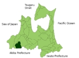
Nishimeya, Aomori
Encyclopedia
is a village
located in the Nakatsugaru District
of southern Aomori Prefecture
in the Tōhoku region
of Japan
. As of 2009, the village had an estimated population
of 1,470 and a density
of 5.97 persons per km². Its total area was 246.58 km².
mountain range. The village has a cold maritime climate characterized by cool short summers and long cold winters with heavy snowfall. The mountainous area is home to many indigenous plant and animal species. Wildlife includes Japanese Macaque monkeys
, kamoshika
, tanuki
and Asian black bears.
a during the Edo period
. It became a village of the Nakatsugaru District on April 1, 1898.
Villages of Japan
A is a local administrative unit in Japan.It is a local public body along with , , and . Geographically, a village's extent is contained within a prefecture....
located in the Nakatsugaru District
Nakatsugaru District, Aomori
is a district located in Aomori Prefecture. The district has an estimated population of 1,599 with a total area of 246,58 km².The district contains only one village.*Nishimeya-Timeline:* April 1, 1889...
of southern Aomori Prefecture
Aomori Prefecture
is a prefecture of Japan located in the Tōhoku Region. The capital is the city of Aomori.- History :Until the Meiji Restoration, the area of Aomori prefecture was known as Mutsu Province....
in the Tōhoku region
Tohoku region
The is a geographical area of Japan. The region occupies the northeastern portion of Honshu, the largest island of Japan. The region consists of six prefectures : Akita, Aomori, Fukushima, Iwate, Miyagi and Yamagata....
of Japan
Japan
Japan is an island nation in East Asia. Located in the Pacific Ocean, it lies to the east of the Sea of Japan, China, North Korea, South Korea and Russia, stretching from the Sea of Okhotsk in the north to the East China Sea and Taiwan in the south...
. As of 2009, the village had an estimated population
Population
A population is all the organisms that both belong to the same group or species and live in the same geographical area. The area that is used to define a sexual population is such that inter-breeding is possible between any pair within the area and more probable than cross-breeding with individuals...
of 1,470 and a density
Population density
Population density is a measurement of population per unit area or unit volume. It is frequently applied to living organisms, and particularly to humans...
of 5.97 persons per km². Its total area was 246.58 km².
Geography
Nishimeya is located in the far southern edge of Aomori Prefecture, bordering Akita Prefecture and the Shirakami-SanchiShirakami-Sanchi
is a UNESCO World Heritage Site in northern Honshū, Japan. This mountainous, unspoiled expanse of virgin forest straddles both Akita and Aomori Prefectures. Of the entire 1,300 km², a tract covering 169.7 km² was included in the list of World Heritage Sites in 1993...
mountain range. The village has a cold maritime climate characterized by cool short summers and long cold winters with heavy snowfall. The mountainous area is home to many indigenous plant and animal species. Wildlife includes Japanese Macaque monkeys
Japanese Macaque
The Japanese macaque , historically known as saru , but now known as Nihonzaru to distinguish it from other primates, is a terrestrial Old World monkey species native to Japan....
, kamoshika
Kamoshika
The was a limited express train service in Japan operated by East Japan Railway Company which ran between and via the Ōu Main Line. The service was discontinued from December 2010.-Service pattern:...
, tanuki
Tanuki
is the common Japanese name for the Japanese raccoon dog . They have been part of Japanese folklore since ancient times...
and Asian black bears.
Neighbouring municipalities
- HirosakiHirosaki, Aomoriis a city located in southwest Aomori Prefecture, Japan. It is a castle town and was the Tsugaru clan ruled the 100,000 koku tozama han Hirosaki Domain from Hirosaki Castle during the Edo period. The city is currently a regional commercial center and the largest producer of apples in Japan...
- AjigasawaAjigasawa, Aomoriis a town located in the Nishitsugaru District of Aomori Prefecture in the Tōhoku region of Japan. As of 2009, the town had an estimated population of 11,561 and a density of 33.7 persons per km²...
- Ōdate, AkitaOdate, Akitais a city located in Akita in Tōhoku region of Japan.The city was founded on April 1, 1951.As of 2003, the city had an estimated population of 65,090 and the density of 162.10 persons per km²...
- Fujisato, AkitaFujisato, Akitais a town located in Yamamoto District, Akita, Japan.As of 2011, the town has an estimated population of 3,861 and a density of 13.7 persons per km². The total area is 281.98 km²....
History
The area around Nishimeya was controlled by the Nambu clan of Morioka DomainMorioka Domain
The was a han or feudal domain that encompasses present-day the middle-northern part of Iwate Prefecture and eastern part of Aomori Prefecture. It is sometimes colloquially called . The domain was tozama daimyo and was governed by the Satake clan. Its income was 100,000...
a during the Edo period
Edo period
The , or , is a division of Japanese history which was ruled by the shoguns of the Tokugawa family, running from 1603 to 1868. The political entity of this period was the Tokugawa shogunate....
. It became a village of the Nakatsugaru District on April 1, 1898.

