

Nieuwerkerk aan den IJssel
Encyclopedia
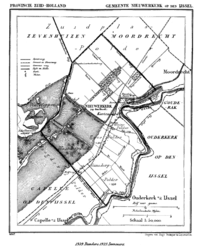
 Nieuwerkerk aan den IJssel (ˈniu̯ərˌkɛrk aːn dɛn ˈɛi̯səɫ) (population: 22,344 in 2004) is a town
Town
A town is a human settlement larger than a village but smaller than a city. The size a settlement must be in order to be called a "town" varies considerably in different parts of the world, so that, for example, many American "small towns" seem to British people to be no more than villages, while...
and former municipality in the western Netherlands
Netherlands
The Netherlands is a constituent country of the Kingdom of the Netherlands, located mainly in North-West Europe and with several islands in the Caribbean. Mainland Netherlands borders the North Sea to the north and west, Belgium to the south, and Germany to the east, and shares maritime borders...
, in the province of South Holland
South Holland
South Holland is a province situated on the North Sea in the western part of the Netherlands. The provincial capital is The Hague and its largest city is Rotterdam.South Holland is one of the most densely populated and industrialised areas in the world...
. Since 2010 it is part of the new municipality of Zuidplas
Zuidplas
Zuidplas is a new municipality by 1 january 2010.Joining of Moordrecht, Nieuwerkerk aan den IJssel and Zevenhuizen-Moerkapelle....
.
It is situated along the Hollandse IJssel
Hollandse IJssel
The Hollandse IJssel is a branch of the Rhine delta that flows westward from Nieuwegein on river Lek through IJsselstein, Gouda and Capelle aan den IJssel to Krimpen aan den IJssel, where it ends in the Nieuwe Maas. Another branch called Enge IJssel flows southwest from Nieuwegein...
river, across from the town Ouderkerk
Ouderkerk
Ouderkerk is a municipality in the western Netherlands, in the province of South Holland. The municipality covers an area of 28.53 km²...
.
Within the boundaries of this municipality lies the lowest point of the Netherlands: 6.76 m (22.2 ft) below Amsterdam Ordnance Datum
Normaal Amsterdams Peil
Normaal Amsterdams Peil or Amsterdam Ordnance Datum is a vertical datum in use in large parts of Western Europe. Originally created for use in the Netherlands, it was adopted by Prussia in 1879 under the name Normalnull, and in 1955 by other European countries.Mayor Johannes Hudde of Amsterdam in...
(mean summer sea level in Amsterdam).
History
Nieuwerkerk was probably first formed circa 1250. The first reference to "Nuwekerke" is from 1282 when Count Floris VFloris V, Count of Holland
Count Floris V of Holland and Zeeland , "der Keerlen God" , is one of the most important figures of the first, native dynasty of Holland . His life was documented in detail in the Rijmkroniek by Melis Stoke, his chronicler...
loaned the land between Kralingen
Kralingen-Crooswijk
Kralingen-Crooswijk is a township of the city of Rotterdam, the Netherlands. It is located at the immediate east of the city's centre. As of 2005 it has about 52,379 inhabitants and has a territory of about 1,286 ha...
and Gouda
Gouda
Gouda is a city and municipality in the western Netherlands, in the province of South Holland. Gouda, which was granted city rights in 1272, is famous for its Gouda cheese, smoking pipes, and 15th-century city hall....
to a certain Traveys of Moordrecht. Another reference is from 22 January 1317 when Count William III of Holland
William I, Count of Hainaut
William I, Count of Hainaut was Count William III of Avesnes, Count William III of Holland and Count William II of Zeeland from 1304 to his death...
sold the fiefdoms Capelle and Nieuwerkerk to Lord Jan van der Werve for 325 Dutch Pounds.
The original old village formed on a mount between shallow lakes. These lakes were the result of peat harvesting. In 1839 the first one was drained and made into a polder
Polder
A polder is a low-lying tract of land enclosed by embankments known as dikes, that forms an artificial hydrological entity, meaning it has no connection with outside water other than through manually-operated devices...
, the current Zuidplaspolder, and in 1866, the Alexanderpolder was made.
The railway between Rotterdam and Gouda was built in 1855 and resulted in the growth of the village. Other periods of rapid development followed after the Second World War and in the early 1980s.
During the North Sea Flood of 1953
North Sea flood of 1953
The 1953 North Sea flood was a major flood caused by a heavy storm, that occurred on the night of Saturday 31 January 1953 and morning of 1 February 1953. The floods struck the Netherlands, Belgium, England and Scotland.A combination of a high spring tide and a severe European windstorm caused a...
, a dike along that river broke, and the mayor of Nieuwerkerk successfully managed to plug the hole by ordering shipper Arie Evegroen to navigate his grain barge Twee Gebroeders (Two Brothers) into it.
Transportation
- Railway station: Nieuwerkerk aan den IJsselNieuwerkerk aan den IJssel railway stationNieuwerkerk aan den IJssel is a railway station in Nieuwerkerk aan den IJssel, the Netherlands. The station is located on the Utrecht–Rotterdam railway between Gouda and Rotterdam Centraal...
External links
- Map of the town
- Welcome to the Lowest Point in Holland website (in English, Dutch, German)
- Official website of Nieuwerkerk aan den IJssel (in Dutch)