

Newfoundland and Labrador Route 431
Encyclopedia
Newfoundland and Labrador
Newfoundland and Labrador is the easternmost province of Canada. Situated in the country's Atlantic region, it incorporates the island of Newfoundland and mainland Labrador with a combined area of . As of April 2011, the province's estimated population is 508,400...
. It begins at a junction of Route 430
Newfoundland and Labrador Route 430
Newfoundland and Labrador Route 430 leads up the Northern Peninsula of Newfoundland and Labrador, from Deer Lake to St. Anthony....
in Wiltondale
Wiltondale, Newfoundland and Labrador
Wiltondale is a settlement in Newfoundland and Labrador....
and terminates at Trout River
Trout River, Newfoundland and Labrador
Trout River is a small rural fishing village located on the southern coastal edge of Gros Morne National Park in Newfoundland. Trout River was settled in 1815 by George Crocker and his family, who were its only inhabitants until 1880. The community is served by Route 431....
. It serves the community of Woody Point
Woody Point, Newfoundland and Labrador
-External links:*...
on Bonne Bay
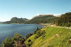
Bonne Bay
Bonne Bay is a bay in Newfoundland, Canada. It is located on the western side of Newfoundland and separates Great Northern Peninsula from the rest of the island. It is a part of Gros Morne National Park. Bonne Bay has a population of about 7000 people....
and passes through the communities of Glenburnie, Birchy Head and Winter House Brook.