

New Zealand State Highway 77
Encyclopedia
State Highway 77 is a State Highway
in New Zealand
going through the inland parts of Central and Mid Canterbury between the towns of Ashburton
and Darfield
via the Rakaia Gorge
. It is wholly single carriageway with two one-lane bridges at the Rakaia
and Selwyn Rivers. One set of traffic lights is found in Ashburton marking the southern terminus of the highway.
About 43 km of the highway lie on the Inland Scenic Route (formerly State Highway 72).
 This is the current route of SH 77 as of June 2010.
The highway begins as Bangor Road just west of Darfield town centre, and proceeds in a westerly directions towards the mountains through flat pastoral farmland. Just before reaching the foothills, the road intersects with the Inland Scenic Route (Deans Road) coming from Waddington
and begins its concurrency at Homebush. After a name change to Homebush Road, the road skirts to the north of Coalgate
and then to the south of Glentunnel
before veering left and narrowing to one lane to cross the Selwyn River.
Now known as Wairiri Road, the road widens back to two lanes and passes through undulating to hilly farmland. At Glenroy the road changes name to Windwhistle Road and climbs towards the settlement of Windwhistle
.
Beyond Windwhistle, the name changes to Rakaia Gorge Road and begins a spectacular descent into the Rakaia Gorge
. For most of its length the Rakaia River
runs on shingle river beds as a braided river
but here the river is mostly a single channel. The river here has carved out the surrounding land to form two level terraces. The road passes over both these terraces before narrowing to one lane again to cross the river.
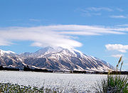
After widening again, the road changes name to Arundel Rakaia Gorge Road and rises towards the plains again. The road emerges onto the plains but passes right underneath the towering Mount Hutt
. The road is frequently covered by snow and ices over in sheltered areas during the calmer periods of the winter months in higher parts of the road.
The road turns left onto Waimarama Road 10 km north of Alford Forest and proceeds through arable farmland, changes name again to Mount Hutt Station Road and arrives in Methven
, where it changes name again to Main Street.
After Methven, the road changes name to Methven Highway and proceeds in a south to southeasterly direction through more pastoral farmland. Before Ashburton, the road hugs the Ashburton River, the name of the road changes to Alford Forest Road for about 2 km, then to River Terrace for 600 m and lastly to Moore Street for the last 300 m of the route before terminating at SH 1 in the town centre.
New Zealand State Highway network
The New Zealand State Highway network is the major national highway network in New Zealand. Just under 100 roads in both the North and South Islands are State Highways...
in New Zealand
New Zealand
New Zealand is an island country in the south-western Pacific Ocean comprising two main landmasses and numerous smaller islands. The country is situated some east of Australia across the Tasman Sea, and roughly south of the Pacific island nations of New Caledonia, Fiji, and Tonga...
going through the inland parts of Central and Mid Canterbury between the towns of Ashburton
Ashburton, New Zealand
Ashburton is a town and district in the Canterbury Region on the east coast of the South Island of New Zealand. It is the third-largest centre in Canterbury, after Christchurch and Timaru. The area around Ashburton is frequently referred to as Mid Canterbury, which is also the name of the...
and Darfield
Darfield, New Zealand
Darfield is a town in the Selwyn District of the South Island of New Zealand. It is located 35 kilometres west from the outskirts of Christchurch, New Zealand on State Highway 73 and the town is on the Midland railway line, route of the famous TranzAlpine train service...
via the Rakaia Gorge
Rakaia Gorge
The Rakaia Gorge is located on the Rakaia River in inland Canterbury in New Zealand's South Island.Like its neighbour, the Waimakariri River, the Rakaia runs through wide shingle beds for much of its length, but is forced through a narrow canyon as it approaches the Canterbury Plains.In the 1870s,...
. It is wholly single carriageway with two one-lane bridges at the Rakaia
Rakaia River
The Rakaia River is in the Canterbury Plains in New Zealand's South Island. The Rakaia River is one of the largest braided rivers in New Zealand...
and Selwyn Rivers. One set of traffic lights is found in Ashburton marking the southern terminus of the highway.
About 43 km of the highway lie on the Inland Scenic Route (formerly State Highway 72).
Route
The highway begins as Bangor Road just west of Darfield town centre, and proceeds in a westerly directions towards the mountains through flat pastoral farmland. Just before reaching the foothills, the road intersects with the Inland Scenic Route (Deans Road) coming from Waddington
Sheffield and Waddington, New Zealand
Sheffield is a small village located in the Selwyn District of the Canterbury region of New Zealand's South Island, near the Waimakariri Gorge....
and begins its concurrency at Homebush. After a name change to Homebush Road, the road skirts to the north of Coalgate
Coalgate, New Zealand
Coalgate is a locality in the Selwyn District of the Canterbury region of New Zealand's South Island. The 2001 New Zealand Census of Population and Dwellings gave Coalgate's population as 276, and it is located roughly an hour west of Christchurch on State Highway 77...
and then to the south of Glentunnel
Glentunnel
Glentunnel is a small village in the Selwyn District of the Canterbury region of New Zealand's South Island. It is officially recognised as a "populated area less than a town". The 2001 New Zealand Census of Population and Dwellings gave Glentunnel's population as 129...
before veering left and narrowing to one lane to cross the Selwyn River.
Now known as Wairiri Road, the road widens back to two lanes and passes through undulating to hilly farmland. At Glenroy the road changes name to Windwhistle Road and climbs towards the settlement of Windwhistle
Windwhistle, New Zealand
Windwhistle is a settlement in the Selwyn District of New Zealand.-References:...
.
Beyond Windwhistle, the name changes to Rakaia Gorge Road and begins a spectacular descent into the Rakaia Gorge
Rakaia Gorge
The Rakaia Gorge is located on the Rakaia River in inland Canterbury in New Zealand's South Island.Like its neighbour, the Waimakariri River, the Rakaia runs through wide shingle beds for much of its length, but is forced through a narrow canyon as it approaches the Canterbury Plains.In the 1870s,...
. For most of its length the Rakaia River
Rakaia River
The Rakaia River is in the Canterbury Plains in New Zealand's South Island. The Rakaia River is one of the largest braided rivers in New Zealand...
runs on shingle river beds as a braided river
Braided river
A braided river is one of a number of channel types and has a channel that consists of a network of small channels separated by small and often temporary islands called braid bars or, in British usage, aits or eyots. Braided streams occur in rivers with high slope and/or large sediment load...
but here the river is mostly a single channel. The river here has carved out the surrounding land to form two level terraces. The road passes over both these terraces before narrowing to one lane again to cross the river.
After widening again, the road changes name to Arundel Rakaia Gorge Road and rises towards the plains again. The road emerges onto the plains but passes right underneath the towering Mount Hutt
Mount Hutt, New Zealand
Mount Hutt rises to the west of the Canterbury Plains in the South Island of New Zealand, above the braided upper reaches of the Rakaia River, and 80 kilometres west of Christchurch...
. The road is frequently covered by snow and ices over in sheltered areas during the calmer periods of the winter months in higher parts of the road.
The road turns left onto Waimarama Road 10 km north of Alford Forest and proceeds through arable farmland, changes name again to Mount Hutt Station Road and arrives in Methven
Methven, New Zealand
Methven is a small town in the Canterbury region of the South Island of New Zealand. It is located near the western edge of the Canterbury Plains, 35 kilometres north of Ashburton. It was originally the railhead of a short branch railway off the Main South Line...
, where it changes name again to Main Street.
After Methven, the road changes name to Methven Highway and proceeds in a south to southeasterly direction through more pastoral farmland. Before Ashburton, the road hugs the Ashburton River, the name of the road changes to Alford Forest Road for about 2 km, then to River Terrace for 600 m and lastly to Moore Street for the last 300 m of the route before terminating at SH 1 in the town centre.
Major Intersections
State Highway 77  |
|||
| Northbound exits | Distance to Darfield (km) |
Distance to Ashburton (km) |
Southbound exits |
| Darfield Darfield, New Zealand Darfield is a town in the Selwyn District of the South Island of New Zealand. It is located 35 kilometres west from the outskirts of Christchurch, New Zealand on State Highway 73 and the town is on the Midland railway line, route of the famous TranzAlpine train service... End as Bangor Road |
0 | 93.9 | Darfield Darfield, New Zealand Darfield is a town in the Selwyn District of the South Island of New Zealand. It is located 35 kilometres west from the outskirts of Christchurch, New Zealand on State Highway 73 and the town is on the Midland railway line, route of the famous TranzAlpine train service... Start as Bangor Road |
| Greymouth Greymouth Greymouth is the largest town in the West Coast region in the South Island of New Zealand, and the seat of the Grey District Council. The population of the whole Grey District is , which accounts for % of the West Coast's inhabitants... , Waddington Sheffield and Waddington, New Zealand Sheffield is a small village located in the Selwyn District of the Canterbury region of New Zealand's South Island, near the Waimakariri Gorge.... , Kirwee Kirwee Kirwee is a town located west of Christchurch in the Canterbury region of New Zealand's South Island. It was named after Karwi in India by retired British Army colonel De Renzie Brett... , Christchurch Christchurch Christchurch is the largest city in the South Island of New Zealand, and the country's second-largest urban area after Auckland. It lies one third of the way down the South Island's east coast, just north of Banks Peninsula which itself, since 2006, lies within the formal limits of... West Coast Road New Zealand State Highway 73 State Highway 73 is a major east-west South Island State Highway in New Zealand connecting Christchurch on the east coast with Greymouth/Hokitika on the west coast via the Southern Alps... .svg.png) South Terrace New Zealand State Highway 73 State Highway 73 is a major east-west South Island State Highway in New Zealand connecting Christchurch on the east coast with Greymouth/Hokitika on the west coast via the Southern Alps...  |
Christchurch Christchurch Christchurch is the largest city in the South Island of New Zealand, and the country's second-largest urban area after Auckland. It lies one third of the way down the South Island's east coast, just north of Banks Peninsula which itself, since 2006, lies within the formal limits of... , Kirwee Kirwee Kirwee is a town located west of Christchurch in the Canterbury region of New Zealand's South Island. It was named after Karwi in India by retired British Army colonel De Renzie Brett... , Waddington Sheffield and Waddington, New Zealand Sheffield is a small village located in the Selwyn District of the Canterbury region of New Zealand's South Island, near the Waimakariri Gorge.... , Greymouth Greymouth Greymouth is the largest town in the West Coast region in the South Island of New Zealand, and the seat of the Grey District Council. The population of the whole Grey District is , which accounts for % of the West Coast's inhabitants... South Terrace New Zealand State Highway 73 State Highway 73 is a major east-west South Island State Highway in New Zealand connecting Christchurch on the east coast with Greymouth/Hokitika on the west coast via the Southern Alps... West Coast Road New Zealand State Highway 73 State Highway 73 is a major east-west South Island State Highway in New Zealand connecting Christchurch on the east coast with Greymouth/Hokitika on the west coast via the Southern Alps... |
||
| Waddington Sheffield and Waddington, New Zealand Sheffield is a small village located in the Selwyn District of the Canterbury region of New Zealand's South Island, near the Waimakariri Gorge.... , Oxford Oxford, New Zealand Oxford is a small town of 1,716 people serving the farming community of North Canterbury, New Zealand. It is part of the Waimakariri District. Oxford is a linear town, approximately two kilometres long. For a time Oxford was serviced by the Oxford Branch railway, and had two stations, East Oxford... Deans Road (Inland Scenic Route) |
7.8 | 86.1 | Waddington Sheffield and Waddington, New Zealand Sheffield is a small village located in the Selwyn District of the Canterbury region of New Zealand's South Island, near the Waimakariri Gorge.... , Oxford Oxford, New Zealand Oxford is a small town of 1,716 people serving the farming community of North Canterbury, New Zealand. It is part of the Waimakariri District. Oxford is a linear town, approximately two kilometres long. For a time Oxford was serviced by the Oxford Branch railway, and had two stations, East Oxford... Deans Road (Inland Scenic Route) |
| End concurrency with Inland Scenic Route Name change to Bangor Road |
Start concurrency with Inland Scenic Route Name change to Homebush Road |
||
| Coalgate Coalgate, New Zealand Coalgate is a locality in the Selwyn District of the Canterbury region of New Zealand's South Island. The 2001 New Zealand Census of Population and Dwellings gave Coalgate's population as 276, and it is located roughly an hour west of Christchurch on State Highway 77... , Hororata Hororata Hororata is a small settlement at the northwestern edge of the Canterbury Plains in the South Island of New Zealand. It is located 15 kilometres southwest of Darfield, five kilometres south of Glentunnel, and 50 kilometres west of Christchurch, on the banks of the Hororata River.Hororata... Bridge Street |
11.1 | 82.8 | Coalgate Coalgate, New Zealand Coalgate is a locality in the Selwyn District of the Canterbury region of New Zealand's South Island. The 2001 New Zealand Census of Population and Dwellings gave Coalgate's population as 276, and it is located roughly an hour west of Christchurch on State Highway 77... , Hororata Hororata Hororata is a small settlement at the northwestern edge of the Canterbury Plains in the South Island of New Zealand. It is located 15 kilometres southwest of Darfield, five kilometres south of Glentunnel, and 50 kilometres west of Christchurch, on the banks of the Hororata River.Hororata... Bridge Street |
| Coalgate Coalgate, New Zealand Coalgate is a locality in the Selwyn District of the Canterbury region of New Zealand's South Island. The 2001 New Zealand Census of Population and Dwellings gave Coalgate's population as 276, and it is located roughly an hour west of Christchurch on State Highway 77... |
11.8 | 82.1 | Coalgate Coalgate, New Zealand Coalgate is a locality in the Selwyn District of the Canterbury region of New Zealand's South Island. The 2001 New Zealand Census of Population and Dwellings gave Coalgate's population as 276, and it is located roughly an hour west of Christchurch on State Highway 77... |
| Glentunnel Glentunnel Glentunnel is a small village in the Selwyn District of the Canterbury region of New Zealand's South Island. It is officially recognised as a "populated area less than a town". The 2001 New Zealand Census of Population and Dwellings gave Glentunnel's population as 129... |
14.2 | 79.7 | Glentunnel Glentunnel Glentunnel is a small village in the Selwyn District of the Canterbury region of New Zealand's South Island. It is officially recognised as a "populated area less than a town". The 2001 New Zealand Census of Population and Dwellings gave Glentunnel's population as 129... |
| Whitecliffs Whitecliffs Whitecliffs is a small town with a population of 117 in the Selwyn District of the Canterbury region of New Zealand's South Island. It has also been known as South Malvern , and the name of Whitecliffs comes from terrace cliffs above the Selwyn River... Whitecliffs Road |
14.7 | 79.2 | Whitecliffs Whitecliffs Whitecliffs is a small town with a population of 117 in the Selwyn District of the Canterbury region of New Zealand's South Island. It has also been known as South Malvern , and the name of Whitecliffs comes from terrace cliffs above the Selwyn River... Whitecliffs Road |
| Name change to Homebush Road | Name change to Wairiri Road | ||
| SELWYN RIVER | 14.8 | 79.1 | SELWYN RIVER |
| Hororata Hororata Hororata is a small settlement at the northwestern edge of the Canterbury Plains in the South Island of New Zealand. It is located 15 kilometres southwest of Darfield, five kilometres south of Glentunnel, and 50 kilometres west of Christchurch, on the banks of the Hororata River.Hororata... Downs Road |
23.9 | 70.0 | Hororata Hororata Hororata is a small settlement at the northwestern edge of the Canterbury Plains in the South Island of New Zealand. It is located 15 kilometres southwest of Darfield, five kilometres south of Glentunnel, and 50 kilometres west of Christchurch, on the banks of the Hororata River.Hororata... Downs Road |
| Name change to Wairiri Road | Name change to Windwhistle Road | ||
| Windwhistle Windwhistle, New Zealand Windwhistle is a settlement in the Selwyn District of New Zealand.-References:... Name change to Windwhistle Road |
34.0 | 59.9 | Windwhistle Windwhistle, New Zealand Windwhistle is a settlement in the Selwyn District of New Zealand.-References:... Name change to Rakaia Gorge Road |
| Lake Coleridge Lake Coleridge Lake Coleridge is located in inland Canterbury, in New Zealand's South Island. Located 35 kilometres to the northwest of Methven, it has a surface area of 47 km².... , Te Pirita, Hororata Hororata Hororata is a small settlement at the northwestern edge of the Canterbury Plains in the South Island of New Zealand. It is located 15 kilometres southwest of Darfield, five kilometres south of Glentunnel, and 50 kilometres west of Christchurch, on the banks of the Hororata River.Hororata... Coleridge Road Leaches Road |
34.6 | 59.3 | Hororata Hororata Hororata is a small settlement at the northwestern edge of the Canterbury Plains in the South Island of New Zealand. It is located 15 kilometres southwest of Darfield, five kilometres south of Glentunnel, and 50 kilometres west of Christchurch, on the banks of the Hororata River.Hororata... , Te Pirita, Lake Coleridge Lake Coleridge Lake Coleridge is located in inland Canterbury, in New Zealand's South Island. Located 35 kilometres to the northwest of Methven, it has a surface area of 47 km².... Leaches Road Coleridge Road |
| Rakaia Gorge Rakaia Gorge The Rakaia Gorge is located on the Rakaia River in inland Canterbury in New Zealand's South Island.Like its neighbour, the Waimakariri River, the Rakaia runs through wide shingle beds for much of its length, but is forced through a narrow canyon as it approaches the Canterbury Plains.In the 1870s,... RAKAIA RIVER Rakaia River The Rakaia River is in the Canterbury Plains in New Zealand's South Island. The Rakaia River is one of the largest braided rivers in New Zealand... Enter Selwyn District Selwyn District The Selwyn District is a predominantly rural area in central Canterbury, on the east coast of New Zealand's South Island. It is named after the Selwyn River, which is in turn named after Bishop George Selwyn, the first Anglican bishop of New Zealand who, in 1843 and 1844, travelled the length of... Name change to Rakaia Gorge Road |
40.5 | 53.4 | Rakaia Gorge Rakaia Gorge The Rakaia Gorge is located on the Rakaia River in inland Canterbury in New Zealand's South Island.Like its neighbour, the Waimakariri River, the Rakaia runs through wide shingle beds for much of its length, but is forced through a narrow canyon as it approaches the Canterbury Plains.In the 1870s,... RAKAIA RIVER Rakaia River The Rakaia River is in the Canterbury Plains in New Zealand's South Island. The Rakaia River is one of the largest braided rivers in New Zealand... Enter Ashburton District Ashburton, New Zealand Ashburton is a town and district in the Canterbury Region on the east coast of the South Island of New Zealand. It is the third-largest centre in Canterbury, after Christchurch and Timaru. The area around Ashburton is frequently referred to as Mid Canterbury, which is also the name of the... Name change to Arundel Rakaia Gorge Road |
| Methven Methven, New Zealand Methven is a small town in the Canterbury region of the South Island of New Zealand. It is located near the western edge of the Canterbury Plains, 35 kilometres north of Ashburton. It was originally the railhead of a short branch railway off the Main South Line... Mount Hutt Station Road (shortcut) |
44.9 | 49.0 | Methven Methven, New Zealand Methven is a small town in the Canterbury region of the South Island of New Zealand. It is located near the western edge of the Canterbury Plains, 35 kilometres north of Ashburton. It was originally the railhead of a short branch railway off the Main South Line... Mount Hutt Station Road (shortcut) |
| Timaru Timaru TimaruUrban AreaPopulation:27,200Extent:Former Timaru City CouncilTerritorial AuthorityName:Timaru District CouncilPopulation:42,867 Land area:2,736.54 km² Mayor:Janie AnnearWebsite:... , Mayfield Mayfield, New Zealand Mayfield is a small farming settlement in Mid Canterbury, in New Zealand's South Island. It is located 35 km from Ashburton on former State Highway 72 at the intersection of the Lismore-Mayfield Road towards the top of the Canterbury Plains. The village has a shop, garage, tavern, local transport... , Mount Hutt Mount Hutt, New Zealand Mount Hutt rises to the west of the Canterbury Plains in the South Island of New Zealand, above the braided upper reaches of the Rakaia River, and 80 kilometres west of Christchurch... Arundel Rakaia Gorge Road (Inland Scenic Route) McLennans Bush Road |
50.4 | 43.5 | Mount Hutt Mount Hutt, New Zealand Mount Hutt rises to the west of the Canterbury Plains in the South Island of New Zealand, above the braided upper reaches of the Rakaia River, and 80 kilometres west of Christchurch... , Mayfield Mayfield, New Zealand Mayfield is a small farming settlement in Mid Canterbury, in New Zealand's South Island. It is located 35 km from Ashburton on former State Highway 72 at the intersection of the Lismore-Mayfield Road towards the top of the Canterbury Plains. The village has a shop, garage, tavern, local transport... , Timaru Timaru TimaruUrban AreaPopulation:27,200Extent:Former Timaru City CouncilTerritorial AuthorityName:Timaru District CouncilPopulation:42,867 Land area:2,736.54 km² Mayor:Janie AnnearWebsite:... McLennans Bush Road Arundel Rakaia Gorge Road (Inland Scenic Route) |
| Name change to Arundel Rakaia Gorge Road Start concurrency with Inland Scenic Route |
Name change to Waimarama Road End concurrency with Inland Scenic Route |
||
| Rakaia Gorge Rakaia Gorge The Rakaia Gorge is located on the Rakaia River in inland Canterbury in New Zealand's South Island.Like its neighbour, the Waimakariri River, the Rakaia runs through wide shingle beds for much of its length, but is forced through a narrow canyon as it approaches the Canterbury Plains.In the 1870s,... Mount Hutt Station Road (shortcut) |
57.3 | 36.6 | Rakaia Gorge Rakaia Gorge The Rakaia Gorge is located on the Rakaia River in inland Canterbury in New Zealand's South Island.Like its neighbour, the Waimakariri River, the Rakaia runs through wide shingle beds for much of its length, but is forced through a narrow canyon as it approaches the Canterbury Plains.In the 1870s,... Mount Hutt Station Road (shortcut) |
| Name change to Waimarama Road | Name change to Mount Hutt Station Road | ||
| Name change to Mount Hutt Station Road | 59.3 | 34.6 | Name change to Main Street |
| Highbank, Barrhill Hall Street |
59.9 | 34.0 | Highbank, Barrhill Hall Street |
| Methven Methven, New Zealand Methven is a small town in the Canterbury region of the South Island of New Zealand. It is located near the western edge of the Canterbury Plains, 35 kilometres north of Ashburton. It was originally the railhead of a short branch railway off the Main South Line... |
60.0 | 33.9 | Methven Methven, New Zealand Methven is a small town in the Canterbury region of the South Island of New Zealand. It is located near the western edge of the Canterbury Plains, 35 kilometres north of Ashburton. It was originally the railhead of a short branch railway off the Main South Line... |
| Alford Forest, Lyndhurst, Lauriston Forest Drive Methven Chertsey Road |
Lyndhurst, Lauriston, Alford Forest Methven Chertsey Road Forest Drive |
||
| Name change to Main Street | 60.8 | 33.1 | Name change to Methven Highway |
| Mount Somers Mount Somers Mount Somers is a small town in Canterbury, New Zealand, nestled in the foothills of the Southern Alps. The population in the 2001 census was 2,307. Due to its scenic location, it has seen growth in the number of holiday homes.... , Rakaia Rakaia The town of Rakaia is seated close to the southern banks of the Rakaia River on the Canterbury Plains in New Zealand's South Island, on State Highway 1 and the Main South Line. Immediately north of the township are the country's longest road bridge and longest rail bridge, both of which cross the... Thompsons Track |
71.6 | 22.3 | Rakaia Rakaia The town of Rakaia is seated close to the southern banks of the Rakaia River on the Canterbury Plains in New Zealand's South Island, on State Highway 1 and the Main South Line. Immediately north of the township are the country's longest road bridge and longest rail bridge, both of which cross the... , Mount Somers Mount Somers Mount Somers is a small town in Canterbury, New Zealand, nestled in the foothills of the Southern Alps. The population in the 2001 census was 2,307. Due to its scenic location, it has seen growth in the number of holiday homes.... Thompsons Track |
| Westerfield, Lauriston Ollivers Road Winchmore Lauriston Road |
81.8 | 12.1 | Lauriston, Westerfield Winchmore Lauriston Road Ollivers Road |
 Racecourse Road |
88.1 | 5.8 | Racecourse Road |
| Allenton, Netherby Harrison Street |
90.9 | 3.0 | Allenton, Netherby Harrison Street |
| Name change to Methven Highway | 91.1 | 2.8 | Name change to Alford Forest Road |
| Allenton, Ashburton Ashburton, New Zealand Ashburton is a town and district in the Canterbury Region on the east coast of the South Island of New Zealand. It is the third-largest centre in Canterbury, after Christchurch and Timaru. The area around Ashburton is frequently referred to as Mid Canterbury, which is also the name of the... Oak Grove Havelock Street |
92.8 | 1.1 | Allenton, Ashburton Ashburton, New Zealand Ashburton is a town and district in the Canterbury Region on the east coast of the South Island of New Zealand. It is the third-largest centre in Canterbury, after Christchurch and Timaru. The area around Ashburton is frequently referred to as Mid Canterbury, which is also the name of the... Havelock Street Oak Grove |
| Name change to Alford Forest Road | Name change to River Terrace | ||
| Name change to River Terrace | 93.5 | 0.4 | Name change to Moore Street |
| Timaru Timaru TimaruUrban AreaPopulation:27,200Extent:Former Timaru City CouncilTerritorial AuthorityName:Timaru District CouncilPopulation:42,867 Land area:2,736.54 km² Mayor:Janie AnnearWebsite:... , Tinwald Tinwald, New Zealand Tinwald is a town in Canterbury, New Zealand, now little more than a suburb of Ashburton. It lies to the south of the larger town, separated from it by the Ashburton River... , Chertsey, Christchurch Christchurch Christchurch is the largest city in the South Island of New Zealand, and the country's second-largest urban area after Auckland. It lies one third of the way down the South Island's east coast, just north of Banks Peninsula which itself, since 2006, lies within the formal limits of... West Street  |
93.9 | 0.0 | Christchurch Christchurch Christchurch is the largest city in the South Island of New Zealand, and the country's second-largest urban area after Auckland. It lies one third of the way down the South Island's east coast, just north of Banks Peninsula which itself, since 2006, lies within the formal limits of... , Chertsey, Tinwald Tinwald, New Zealand Tinwald is a town in Canterbury, New Zealand, now little more than a suburb of Ashburton. It lies to the south of the larger town, separated from it by the Ashburton River... , Timaru Timaru TimaruUrban AreaPopulation:27,200Extent:Former Timaru City CouncilTerritorial AuthorityName:Timaru District CouncilPopulation:42,867 Land area:2,736.54 km² Mayor:Janie AnnearWebsite:... West Street |
| Ashburton Ashburton, New Zealand Ashburton is a town and district in the Canterbury Region on the east coast of the South Island of New Zealand. It is the third-largest centre in Canterbury, after Christchurch and Timaru. The area around Ashburton is frequently referred to as Mid Canterbury, which is also the name of the... End continues as Moore Street to Hampstead, Wakanui |
|||
External links
- View from Rakaia Gorge Bridge - Google Street ViewGoogle Street ViewGoogle Street View is a technology featured in Google Maps and Google Earth that provides panoramic views from various positions along many streets in the world...
- http://maps.google.com/maps?f=d&source=s_d&saddr=-43.488113,172.105851&daddr=Arundel+Rakaia+Gorge+Rd+to:Methven,+New+Zealand+to:Moore+St&hl=en&geocode=%3BFSwsZ_0dhjU6Cg%3BFYo3Zv0dKiA7CinxzQzIXc4tbTEH33IqzLAMdA%3BFWoOYv0dUp48Cg&mra=dme&mrcr=0&mrsp=0&sz=15&via=1&sll=-43.48914,172.114348&sspn=0.015568,0.038581&ie=UTF8&ll=-43.673832,171.936035&spn=0.496639,1.234589&t=h&z=10State Highway 77 on Google Maps]