

New York State Route 218
Encyclopedia
New York State Route 218 (NY 218) is a state highway
located within Orange County, New York
, in the United States
. It loops off U.S. Route 9W to run closer to the Hudson River
between Highland Falls
and Cornwall-on-Hudson. North of Highland Falls, it is briefly concurrent
with US 9W.
NY 218 sees much traffic despite its short length. Not only does it bring most of the United States Military Academy
's traffic to Thayer Gate, its main entrance, it attracts many who drive it just for the sake of its most renowned portion: the cliffside drive alongside Storm King Mountain. In good weather during the summer months many cars can be seen taking in the views of the river and the Hudson Highlands
here (however, this section can be gated off and closed in times of high rockslide
danger).
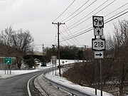 NY 218 forks off 9W a short distance north of the Bear Mountain Traffic Circle, near the ruins of the old Fort Montgomery. A mile from that junction, it turns from northeast to more northerly and reaches downtown Highland Falls
. After several blocks USMA's Thayer Gate becomes apparent, and instead of entering the academy grounds the state highway veers northwestward and uphill, rejoining 9W in Highlands
, at this point a four-lane divided highway.
After going up and down one of the rises in this area, NY 218 again splits off at the exit where NY 293
comes in from the west, just adjacent to West Point's Washington Gate. This section passes through less developed, woodsier property before reaching the southern of two gates that block access to the Storm King section in bad weather.
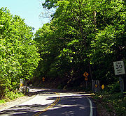 The next mile and a half wind leisurely along a narrow roadway where a picturesque stone wall serves to prevent drivers from tumbling into the river. There are several small parking areas where it is possible to stop and take in the vistas that stretch from the Newburgh-Beacon Bridge
to the north over Pollopel Island to West Point and the USMA buildings at the southern end. Breakneck Ridge
and other mountains of the Highlands tower across the river. The view and the walls led this section to be added to the National Register of Historic Places
in 1982 as "Storm King Highway
".
The northern gate heralds re-entry into populated areas as the houses of Cornwall-on-Hudson begin alongside the road not long afterwards, and it takes the name Bayview Avenue. After becoming Hudson Street in the village's downtown section, NY 218 then follows Academy Avenue (the former Route 307 once had its eastern terminus at that intersection). Appropriately enough, it passes the New York Military Academy
, a private secondary school, and reaches its northern terminus at US 9W immediately afterward.
extending from the New Jersey
state line in Rockland County
to Albany
by way of the Hudson River
's west bank. The route mostly followed what is now U.S. Route 9W; however, from Highland Falls
to Cornwall-on-Hudson, it used modern NY 218 instead. Much of legislative Route 3 became part of NY 10
when the first set of posted routes in New York
were assigned in 1924 and part of US 9W when it was originally assigned in 1927.
In the early 1930s, plans were made by the state of New York to construct a new highway between the Bear Mountain Bridge
and Cornwall-on-Hudson that would bypass both Cornwall-on-Hudson and Highland Falls and bypass the narrow Storm King Highway
. On April 8, 1934, three people were killed by a rockslide on the Storm King Highway, expediting plans for the new highway, known as the Storm King Cut-off. It was constructed in stages from 1937 to 1941, with the final segment of the highway (from Angola Road north to Blooming Grove Turnpike north of Cornwall-on-Hudson) opening to traffic on May 31, 1941. US 9W was realigned to follow the cut-off while its old route via the Storm King Highway became NY 218.
During the forest fires on Storm King during the summer of 1999, NY 218 was closed for many weeks.
State highway
State highway, state road or state route can refer to one of three related concepts, two of them related to a state or provincial government in a country that is divided into states or provinces :#A...
located within Orange County, New York
Orange County, New York
Orange County is a county located in the U.S. state of New York. It is part of the Poughkeepsie–Newburgh–Middletown, NY Metropolitan Statistical Area and is located at the northern reaches of the New York metropolitan area. The county sits in the state's scenic Mid-Hudson Region of the Hudson Valley...
, in the United States
United States
The United States of America is a federal constitutional republic comprising fifty states and a federal district...
. It loops off U.S. Route 9W to run closer to the Hudson River
Hudson River
The Hudson is a river that flows from north to south through eastern New York. The highest official source is at Lake Tear of the Clouds, on the slopes of Mount Marcy in the Adirondack Mountains. The river itself officially begins in Henderson Lake in Newcomb, New York...
between Highland Falls
Highland Falls, New York
Highland Falls, formerly named Buttermilk Falls, is a village in Orange County, New York, United States. The population was 3,678 at the 2000 census. The village was founded in 1906...
and Cornwall-on-Hudson. North of Highland Falls, it is briefly concurrent
Concurrency (road)
A concurrency, overlap, or coincidence in a road network is an instance of one physical road bearing two or more different highway, motorway, or other route numbers...
with US 9W.
NY 218 sees much traffic despite its short length. Not only does it bring most of the United States Military Academy
United States Military Academy
The United States Military Academy at West Point is a four-year coeducational federal service academy located at West Point, New York. The academy sits on scenic high ground overlooking the Hudson River, north of New York City...
's traffic to Thayer Gate, its main entrance, it attracts many who drive it just for the sake of its most renowned portion: the cliffside drive alongside Storm King Mountain. In good weather during the summer months many cars can be seen taking in the views of the river and the Hudson Highlands
Hudson Highlands
The Hudson Highlands are mountains on both sides of the Hudson River in the U.S. state of New York, between Newburgh Bay and Haverstraw Bay, which form the northern region of the New York - New Jersey Highlands....
here (however, this section can be gated off and closed in times of high rockslide
Rockslide
A rockslide is a type of landslide caused by rock failure in which part of the plane of failure passes through intact rock and where material collapses en masse and not in individual blocks.The mode of failure is different from that of a rock-fall....
danger).
Route description
Highland Falls, New York
Highland Falls, formerly named Buttermilk Falls, is a village in Orange County, New York, United States. The population was 3,678 at the 2000 census. The village was founded in 1906...
. After several blocks USMA's Thayer Gate becomes apparent, and instead of entering the academy grounds the state highway veers northwestward and uphill, rejoining 9W in Highlands
Highlands, New York
Highlands is a town in Orange County, New York, United States. The population was 12,484 at the 2000 census.The Town of Highlands is on the eastern border of the county....
, at this point a four-lane divided highway.
After going up and down one of the rises in this area, NY 218 again splits off at the exit where NY 293
New York State Route 293
New York State Route 293 is a state highway located entirely within eastern Orange County, New York, in the United States. The highway starts at U.S. Route 6 in Woodbury, and heads to the northeast, ending at an intersection with US 9W and NY 218 in the community of Highlands...
comes in from the west, just adjacent to West Point's Washington Gate. This section passes through less developed, woodsier property before reaching the southern of two gates that block access to the Storm King section in bad weather.
Newburgh-Beacon Bridge
The Newburgh–Beacon Bridge, is a cantilever toll bridge that spans the Hudson River in New York State carrying NY 52 and Interstate 84 between Newburgh and Beacon...
to the north over Pollopel Island to West Point and the USMA buildings at the southern end. Breakneck Ridge
Breakneck Ridge
Breakneck Ridge is a mountain along the Hudson River between Beacon and Cold Spring, New York, straddling the boundary between Dutchess and Putnam counties...
and other mountains of the Highlands tower across the river. The view and the walls led this section to be added to the National Register of Historic Places
National Register of Historic Places
The National Register of Historic Places is the United States government's official list of districts, sites, buildings, structures, and objects deemed worthy of preservation...
in 1982 as "Storm King Highway
Storm King Highway
The Storm King Highway is a three-mile segment of NY 218 between Lee Road in the Town of Highlands at the south end and the Cornwall-on-Hudson village line in Orange County, New York, United States...
".
The northern gate heralds re-entry into populated areas as the houses of Cornwall-on-Hudson begin alongside the road not long afterwards, and it takes the name Bayview Avenue. After becoming Hudson Street in the village's downtown section, NY 218 then follows Academy Avenue (the former Route 307 once had its eastern terminus at that intersection). Appropriately enough, it passes the New York Military Academy
New York Military Academy
New York Military Academy, or NYMA, is an American private boarding school located in Cornwall-on-Hudson, New York. It was founded in 1889 by Charles Jefferson Wright, a Civil War veteran and former school teacher from New Hampshire who believed that a military structure provided the best...
, a private secondary school, and reaches its northern terminus at US 9W immediately afterward.
History
In 1908, the New York State Legislature created Route 3, an unsigned legislative routeLegislative route
In United States, a legislative route or legislative highway is a highway defined by laws passed in a state legislature. The numbering of such highways may or may not correspond to the numbers familiar to the public as part of the state, U.S. highway, and Interstate highway systems...
extending from the New Jersey
New Jersey
New Jersey is a state in the Northeastern and Middle Atlantic regions of the United States. , its population was 8,791,894. It is bordered on the north and east by the state of New York, on the southeast and south by the Atlantic Ocean, on the west by Pennsylvania and on the southwest by Delaware...
state line in Rockland County
Rockland County, New York
Rockland County is a suburban county 15 miles to the northwest of Manhattan and part of the New York City Metropolitan Area, in the U.S. state of New York. It is the southernmost county in New York west of the Hudson River, and the smallest county in New York outside of New York City. The...
to Albany
Albany, New York
Albany is the capital city of the U.S. state of New York, the seat of Albany County, and the central city of New York's Capital District. Roughly north of New York City, Albany sits on the west bank of the Hudson River, about south of its confluence with the Mohawk River...
by way of the Hudson River
Hudson River
The Hudson is a river that flows from north to south through eastern New York. The highest official source is at Lake Tear of the Clouds, on the slopes of Mount Marcy in the Adirondack Mountains. The river itself officially begins in Henderson Lake in Newcomb, New York...
's west bank. The route mostly followed what is now U.S. Route 9W; however, from Highland Falls
Highland Falls, New York
Highland Falls, formerly named Buttermilk Falls, is a village in Orange County, New York, United States. The population was 3,678 at the 2000 census. The village was founded in 1906...
to Cornwall-on-Hudson, it used modern NY 218 instead. Much of legislative Route 3 became part of NY 10
New York State Route 10
New York State Route 10 is a north–south state highway in the Central New York and North Country regions of New York in the United States. It extends for from the Quickway in Deposit, Delaware County to NY 8 at Higgins Bay, a hamlet in the Hamilton County town of Arietta...
when the first set of posted routes in New York
New York
New York is a state in the Northeastern region of the United States. It is the nation's third most populous state. New York is bordered by New Jersey and Pennsylvania to the south, and by Connecticut, Massachusetts and Vermont to the east...
were assigned in 1924 and part of US 9W when it was originally assigned in 1927.
In the early 1930s, plans were made by the state of New York to construct a new highway between the Bear Mountain Bridge
Bear Mountain Bridge
The Bear Mountain Bridge is a toll suspension bridge in New York State, carrying U.S. Highways 202 and 6 across the Hudson River between Rockland and Westchester counties...
and Cornwall-on-Hudson that would bypass both Cornwall-on-Hudson and Highland Falls and bypass the narrow Storm King Highway
Storm King Highway
The Storm King Highway is a three-mile segment of NY 218 between Lee Road in the Town of Highlands at the south end and the Cornwall-on-Hudson village line in Orange County, New York, United States...
. On April 8, 1934, three people were killed by a rockslide on the Storm King Highway, expediting plans for the new highway, known as the Storm King Cut-off. It was constructed in stages from 1937 to 1941, with the final segment of the highway (from Angola Road north to Blooming Grove Turnpike north of Cornwall-on-Hudson) opening to traffic on May 31, 1941. US 9W was realigned to follow the cut-off while its old route via the Storm King Highway became NY 218.
During the forest fires on Storm King during the summer of 1999, NY 218 was closed for many weeks.