

New York State Route 145
Encyclopedia
New York State Route 145 (NY 145) is a state highway
in eastern New York
in the United States
. The highway extends for 46.99 miles (75.62 km) from NY 23
in the Greene County
town of Cairo
to U.S. Route 20 in the Schoharie County
town of Sharon
. Along the way, NY 145 intersects NY 30
in Middleburgh
and Interstate 88
east of Cobleskill
. NY 145 is a two-lane highway its entire length, with a passing lane on hills leaving Middleburgh in both directions.
The route follows parts of the Susquehannah Turnpike
from Cairo through East Durham and west.
northwest of the hamlet
of Cairo
in the Greene County
town of the same name
. NY 145 follows a northwesterly course, roughly paralleling Catskill Creek
as it heads through the area. Due to its proximity to the creek, the route passes by many resort-type businesses (including camping and swimming) both in the town of Cairo and in the adjacent town of Durham
. Some light industry is also present, primarily in the vicinity of the hamlets of East Durham and Durham.
The route quietly crosses into Albany County
12.5 miles (20.1 km) northwest of its southern end at NY 23. Despite the change in county, the surroundings of the route remain largely unchanged—rural and scarcely developed. NY 145 is in Albany County for just 5 miles (8 km) and enters only one town, Rensselaerville
. As in Greene County, additional camping and souvenir vendors are present along the route due to its location on the banks of the Catskill Creek. Within the county, NY 145 meets the western terminus of NY 81
in the hamlet of Cooksburg 0.5 mile (0.80467 km) north of the Greene–Albany county line and serves the hamlet of Preston Hollow.
town of Broome
, NY 145 continues its northwesterly course for an additional two miles (3 km), then bends to be more northward to pass by the hamlets of Livingstonville and Franklinton. At Franklinton, NY 145 passes by Vlaie Pond, the northwestern end of Catskill Creek. Approaching the Schoharie Valley, NY 145 heads downhill along a lengthy stretch that includes a passing lane for southbound traffic. At the bottom of the hill, NY 145 enters Middleburgh
as Main Street. In Middleburgh, there is a 0.1 mile (0.160934 km) long wrong-way concurrency with NY 30
on the bridge carrying both routes over Schoharie Creek
.
 After crossing the creek, NY 145 leaves NY 30 and parallels it briefly to the west, then heads more northwesterly again. Leaving the Schoharie Valley, a passing lane is present northbound. Upon entering the town of Cobleskill
, the route levels off and curves to the west. It serves the small community of East Cobleskill before meeting I-88 at exit 22, then NY 7
0.2 mile (0.321868 km) later east of Cobleskill
and west of Howe Caverns
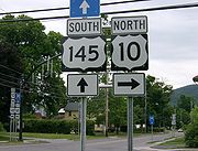
, a regional tourist attraction. NY 145 then joins NY 7 westward to Cobleskill as East Main Street. In downtown, the two routes meet NY 10
. NY 10 joins NY 7 for a concurrency westward, while NY 145 leaves NY 7 and joins NY 10 as North Grand Street for a 0.23 mile (0.3701482 km) long concurrency within the village. Leaving Cobleskill, NY 145 passes through the hamlet of Lawyersville before terminating at U.S. Route 20 in the hamlet of Sharon
.
extending from Cairo
in Greene County
to Cooksburg in Albany County
via Durham
. One year later, the legislature created Route 38-a, which began in Cobleskill
and passed through Sharon
before ending in Sharon Springs
. On March 1, 1921, Route 5-b was eliminated while Route 38-a became part of Route 39, which continued west along what is now US 20 from Sharon Springs to the town of Madison
. None of former Route 5-b nor the portion of Route 39 south of Sharon received a signed designation when the first set of posted routes in New York
were assigned in 1924.
In the 1930 renumbering of state highways in New York, all of former legislative Route 5-b was designated as NY 145 while the Cobleskill–Sharon segment of former legislative Route 39 was assigned NY 164. At the same time, what is now NY 145 from Cooksburg to Middleburgh
was designated as part of NY 81
. The section of modern NY 145 between Middleburgh and NY 7
east of Cobleskill was assigned NY 433 ca. 1937. By the following year, NY 145 was extended northward to Middleburgh while NY 81 was truncated southward to Cooksburg. NY 145 was extended again in both directions ca. 1940. On its north end, it was altered to continue northwest through Cobleskill to Sharon, supplanting both NY 164 and NY 433 and briefly overlapping with NY 7 and NY 30
in Cobleskill and Middleburgh, respectively. On its south end, it was modified to overlap with NY 23
eastward to Catskill
on what is now County Route 23B (CR 23B).
NY 145 originally entered the hamlet of Cairo on what is now CR 84 and met NY 23 in the center of the community at what is now CR 23B. Both NY 23 and NY 145 were realigned in the 1960s to follow a new arterial between Cairo and the Rip Van Winkle Bridge in Catskill. The first segment of the highway, a northerly bypass of the hamlet of Cairo, opened ca. 1961. The remainder of the arterial was completed in the mid-1960s. On January 1, 1970, NY 145 was truncated back to its current southern terminus in Cairo, eliminating the overlap between NY 23 and NY 145.
State highway
State highway, state road or state route can refer to one of three related concepts, two of them related to a state or provincial government in a country that is divided into states or provinces :#A...
in eastern New York
New York
New York is a state in the Northeastern region of the United States. It is the nation's third most populous state. New York is bordered by New Jersey and Pennsylvania to the south, and by Connecticut, Massachusetts and Vermont to the east...
in the United States
United States
The United States of America is a federal constitutional republic comprising fifty states and a federal district...
. The highway extends for 46.99 miles (75.62 km) from NY 23
New York State Route 23
New York State Route 23 is an east–west state highway in the eastern portion New York in the United States. It extends for from an intersection with NY 26 in the Central New York town of Cincinnatus to the Massachusetts state line in the Berkshire Mountains, where it continues east as...
in the Greene County
Greene County, New York
Greene County is a county located in the U.S. state of New York. Its name is in honor of the American Revolutionary War general Nathanael Greene. Its county seat is Catskill...
town of Cairo
Cairo (town), New York
Cairo is a town in Greene County, New York, United States. The population was 6,610 at the 2010 census. The town is in the south part of the county, partly in the Catskill Park. Cairo is named after Cairo in Egypt, but is pronounced "Care-o" .- History :...
to U.S. Route 20 in the Schoharie County
Schoharie County, New York
As of the census of 2000, there were 31,582 people, 11,991 households and 8,177 families residing in the county. The population density was 51 people per square mile . There were 15,915 housing units at an average density of 26 per square mile...
town of Sharon
Sharon, New York
Sharon is a town in Schoharie County, New York, United States. The population was 1,843 at the 2000 census. The town is named after a location in Connecticut, from where some early settlers came....
. Along the way, NY 145 intersects NY 30
New York State Route 30
New York State Route 30 is a state highway in the central part of New York in the United States. It extends for from an interchange with NY 17 in the Southern Tier to the Canadian border in the state's North Country, where it continues into Quebec as Route 138. On a regional level,...
in Middleburgh
Middleburgh (village), New York
Middleburgh is a village in Schoharie County, New York, USA. The population was 1,398 at the 2000 census.The Village of Middleburgh is in the southwest part of the Town of Middleburgh and is west of Albany.- History :...
and Interstate 88
Interstate 88 (east)
Interstate 88 is an intrastate Interstate Highway entirely within the U.S. state of New York. Its western end is at Interstate 81 in Binghamton and its eastern end is at Interstate 90 in Schenectady. It serves as an important connector route from Albany to Binghamton, Elmira , and...
east of Cobleskill
Cobleskill (village), New York
Cobleskill is a village in the western part of the town of Cobleskill in Schoharie County, New York, USA. The population was 4,533 at the 2000 census.The village is southwest of Amsterdam...
. NY 145 is a two-lane highway its entire length, with a passing lane on hills leaving Middleburgh in both directions.
The route follows parts of the Susquehannah Turnpike
Susquehannah Turnpike
Susquehannah Turnpike is a historic 25 mile turnpike beginning at Catskill on the Hudson River and stretching through the town of Durham in Greene County, New York. Part of the route follows the Mohican Trail and it features a number of stone arch bridges. Nine of the 25 original milestones...
from Cairo through East Durham and west.
Greene and Albany Counties
NY 145 begins at a junction with NY 23New York State Route 23
New York State Route 23 is an east–west state highway in the eastern portion New York in the United States. It extends for from an intersection with NY 26 in the Central New York town of Cincinnatus to the Massachusetts state line in the Berkshire Mountains, where it continues east as...
northwest of the hamlet
Hamlet (place)
A hamlet is usually a rural settlement which is too small to be considered a village, though sometimes the word is used for a different sort of community. Historically, when a hamlet became large enough to justify building a church, it was then classified as a village...
of Cairo
Cairo (CDP), New York
Cairo is a census-designated place in the town of Cairo in Greene County, New York, United States. The population was 1,390 at the 2000 census.-Geography:Cairo is located at ....
in the Greene County
Greene County, New York
Greene County is a county located in the U.S. state of New York. Its name is in honor of the American Revolutionary War general Nathanael Greene. Its county seat is Catskill...
town of the same name
Cairo (town), New York
Cairo is a town in Greene County, New York, United States. The population was 6,610 at the 2010 census. The town is in the south part of the county, partly in the Catskill Park. Cairo is named after Cairo in Egypt, but is pronounced "Care-o" .- History :...
. NY 145 follows a northwesterly course, roughly paralleling Catskill Creek
Catskill Creek
Catskill Creek is a tributary of the Hudson River that drains the east northern Catskill Mountains of the U.S. state of New York. From its source at Franklinton Vlaie in Schoharie County it flows southeast through parts of Albany County and Greene County to its mouth at the village of Catskill on...
as it heads through the area. Due to its proximity to the creek, the route passes by many resort-type businesses (including camping and swimming) both in the town of Cairo and in the adjacent town of Durham
Durham, New York
Durham is a town in Greene County, New York, United States. The population was 2,725 at the 2010 census. The town was named after Durham, Connecticut.The Town of Durham is in the northwest corner of the county.- History :...
. Some light industry is also present, primarily in the vicinity of the hamlets of East Durham and Durham.
The route quietly crosses into Albany County
Albany County, New York
Albany County is a county located in the U.S. state of New York, and is part of the Albany-Schenectady-Troy Metropolitan Statistical Area. The name is from the title of the Duke of York and Albany, who became James II of England . As of the 2010 census, the population was 304,204...
12.5 miles (20.1 km) northwest of its southern end at NY 23. Despite the change in county, the surroundings of the route remain largely unchanged—rural and scarcely developed. NY 145 is in Albany County for just 5 miles (8 km) and enters only one town, Rensselaerville
Rensselaerville, New York
Rensselaerville is a town in Albany County, New York, United States. The population was 1,843 at the 2010 census. The town is named after Stephen Van Rensselaer...
. As in Greene County, additional camping and souvenir vendors are present along the route due to its location on the banks of the Catskill Creek. Within the county, NY 145 meets the western terminus of NY 81
New York State Route 81
New York State Route 81 is an east–west state highway in the Capital District of New York, United States. The western terminus of the route is at NY 145 in the hamlet of Cooksburg within the town of Rensselaerville. The eastern terminus is at U.S. Route 9W in the town of Coxsackie...
in the hamlet of Cooksburg 0.5 mile (0.80467 km) north of the Greene–Albany county line and serves the hamlet of Preston Hollow.
Schoharie County
In the Schoharie CountySchoharie County, New York
As of the census of 2000, there were 31,582 people, 11,991 households and 8,177 families residing in the county. The population density was 51 people per square mile . There were 15,915 housing units at an average density of 26 per square mile...
town of Broome
Broome, New York
----Broome is a town in Schoharie County, New York, United States. The population was 947 at the 2000 census. The town is named after John Broome.The Town of Broome is on the eastern border of the county, southwest of Albany.- History :...
, NY 145 continues its northwesterly course for an additional two miles (3 km), then bends to be more northward to pass by the hamlets of Livingstonville and Franklinton. At Franklinton, NY 145 passes by Vlaie Pond, the northwestern end of Catskill Creek. Approaching the Schoharie Valley, NY 145 heads downhill along a lengthy stretch that includes a passing lane for southbound traffic. At the bottom of the hill, NY 145 enters Middleburgh
Middleburgh (village), New York
Middleburgh is a village in Schoharie County, New York, USA. The population was 1,398 at the 2000 census.The Village of Middleburgh is in the southwest part of the Town of Middleburgh and is west of Albany.- History :...
as Main Street. In Middleburgh, there is a 0.1 mile (0.160934 km) long wrong-way concurrency with NY 30
New York State Route 30
New York State Route 30 is a state highway in the central part of New York in the United States. It extends for from an interchange with NY 17 in the Southern Tier to the Canadian border in the state's North Country, where it continues into Quebec as Route 138. On a regional level,...
on the bridge carrying both routes over Schoharie Creek
Schoharie Creek
Schoharie Creek in New York, USA flows north from the foot of Indian Head Mountain in the Catskill Mountains through the Schoharie Valley to the Mohawk River. It is twice impounded north of Prattsville to create New York City's Schoharie Reservoir and the Blenheim-Gilboa Power Project.Two notable...
.
Cobleskill (town), New York
Cobleskill is a town in Schoharie County, New York, USA. The population was 6,407 at the 2000 census. The town contains a village, also named Cobleskill, as well as the State University of New York at Cobleskill....
, the route levels off and curves to the west. It serves the small community of East Cobleskill before meeting I-88 at exit 22, then NY 7
New York State Route 7
New York State Route 7 is a 180-mile long New York State Highway that runs from the New York/Pennsylvania border south of Binghamton, New York to the New York/Vermont border east of Hoosick. Most of the road runs along the Susquehanna Valley, closely paralleling Interstate 88 throughout...
0.2 mile (0.321868 km) later east of Cobleskill
Cobleskill (village), New York
Cobleskill is a village in the western part of the town of Cobleskill in Schoharie County, New York, USA. The population was 4,533 at the 2000 census.The village is southwest of Amsterdam...
and west of Howe Caverns
Howe Caverns
Howe Caverns is a cave in Howes Cave, Schoharie County, New York.-Geology:Geologists believe that the formation of the cave, which lies below ground, began several million years ago...
, a regional tourist attraction. NY 145 then joins NY 7 westward to Cobleskill as East Main Street. In downtown, the two routes meet NY 10
New York State Route 10
New York State Route 10 is a north–south state highway in the Central New York and North Country regions of New York in the United States. It extends for from the Quickway in Deposit, Delaware County to NY 8 at Higgins Bay, a hamlet in the Hamilton County town of Arietta...
. NY 10 joins NY 7 for a concurrency westward, while NY 145 leaves NY 7 and joins NY 10 as North Grand Street for a 0.23 mile (0.3701482 km) long concurrency within the village. Leaving Cobleskill, NY 145 passes through the hamlet of Lawyersville before terminating at U.S. Route 20 in the hamlet of Sharon
Sharon, New York
Sharon is a town in Schoharie County, New York, United States. The population was 1,843 at the 2000 census. The town is named after a location in Connecticut, from where some early settlers came....
.
History
In 1911, the New York State Legislature created Route 5-b, an unsigned legislative routeLegislative route
In United States, a legislative route or legislative highway is a highway defined by laws passed in a state legislature. The numbering of such highways may or may not correspond to the numbers familiar to the public as part of the state, U.S. highway, and Interstate highway systems...
extending from Cairo
Cairo (CDP), New York
Cairo is a census-designated place in the town of Cairo in Greene County, New York, United States. The population was 1,390 at the 2000 census.-Geography:Cairo is located at ....
in Greene County
Greene County, New York
Greene County is a county located in the U.S. state of New York. Its name is in honor of the American Revolutionary War general Nathanael Greene. Its county seat is Catskill...
to Cooksburg in Albany County
Albany County, New York
Albany County is a county located in the U.S. state of New York, and is part of the Albany-Schenectady-Troy Metropolitan Statistical Area. The name is from the title of the Duke of York and Albany, who became James II of England . As of the 2010 census, the population was 304,204...
via Durham
Durham, New York
Durham is a town in Greene County, New York, United States. The population was 2,725 at the 2010 census. The town was named after Durham, Connecticut.The Town of Durham is in the northwest corner of the county.- History :...
. One year later, the legislature created Route 38-a, which began in Cobleskill
Cobleskill (village), New York
Cobleskill is a village in the western part of the town of Cobleskill in Schoharie County, New York, USA. The population was 4,533 at the 2000 census.The village is southwest of Amsterdam...
and passed through Sharon
Sharon, New York
Sharon is a town in Schoharie County, New York, United States. The population was 1,843 at the 2000 census. The town is named after a location in Connecticut, from where some early settlers came....
before ending in Sharon Springs
Sharon Springs, New York
Sharon Springs is a village in Schoharie County, New York, United States. The population was 547 at the 2000 census. Its name derives from the hometown of the first Colonial settlers, Sharon, Connecticut, and the important springs in the village...
. On March 1, 1921, Route 5-b was eliminated while Route 38-a became part of Route 39, which continued west along what is now US 20 from Sharon Springs to the town of Madison
Madison (town), New York
Madison is a town in Madison County, New York, United States. The population was 2,801 at the 2000 census.The Town of Madison contains a village also named Madison. The town is on the eastern border of the county.- History :...
. None of former Route 5-b nor the portion of Route 39 south of Sharon received a signed designation when the first set of posted routes in New York
New York
New York is a state in the Northeastern region of the United States. It is the nation's third most populous state. New York is bordered by New Jersey and Pennsylvania to the south, and by Connecticut, Massachusetts and Vermont to the east...
were assigned in 1924.
In the 1930 renumbering of state highways in New York, all of former legislative Route 5-b was designated as NY 145 while the Cobleskill–Sharon segment of former legislative Route 39 was assigned NY 164. At the same time, what is now NY 145 from Cooksburg to Middleburgh
Middleburgh (village), New York
Middleburgh is a village in Schoharie County, New York, USA. The population was 1,398 at the 2000 census.The Village of Middleburgh is in the southwest part of the Town of Middleburgh and is west of Albany.- History :...
was designated as part of NY 81
New York State Route 81
New York State Route 81 is an east–west state highway in the Capital District of New York, United States. The western terminus of the route is at NY 145 in the hamlet of Cooksburg within the town of Rensselaerville. The eastern terminus is at U.S. Route 9W in the town of Coxsackie...
. The section of modern NY 145 between Middleburgh and NY 7
New York State Route 7
New York State Route 7 is a 180-mile long New York State Highway that runs from the New York/Pennsylvania border south of Binghamton, New York to the New York/Vermont border east of Hoosick. Most of the road runs along the Susquehanna Valley, closely paralleling Interstate 88 throughout...
east of Cobleskill was assigned NY 433 ca. 1937. By the following year, NY 145 was extended northward to Middleburgh while NY 81 was truncated southward to Cooksburg. NY 145 was extended again in both directions ca. 1940. On its north end, it was altered to continue northwest through Cobleskill to Sharon, supplanting both NY 164 and NY 433 and briefly overlapping with NY 7 and NY 30
New York State Route 30
New York State Route 30 is a state highway in the central part of New York in the United States. It extends for from an interchange with NY 17 in the Southern Tier to the Canadian border in the state's North Country, where it continues into Quebec as Route 138. On a regional level,...
in Cobleskill and Middleburgh, respectively. On its south end, it was modified to overlap with NY 23
New York State Route 23
New York State Route 23 is an east–west state highway in the eastern portion New York in the United States. It extends for from an intersection with NY 26 in the Central New York town of Cincinnatus to the Massachusetts state line in the Berkshire Mountains, where it continues east as...
eastward to Catskill
Catskill (town), New York
Catskill is a town in the southeast part of Greene County, New York, United States. The population was 11,775 at the 2010 census. The western part of the town is in the Catskill Park....
on what is now County Route 23B (CR 23B).
NY 145 originally entered the hamlet of Cairo on what is now CR 84 and met NY 23 in the center of the community at what is now CR 23B. Both NY 23 and NY 145 were realigned in the 1960s to follow a new arterial between Cairo and the Rip Van Winkle Bridge in Catskill. The first segment of the highway, a northerly bypass of the hamlet of Cairo, opened ca. 1961. The remainder of the arterial was completed in the mid-1960s. On January 1, 1970, NY 145 was truncated back to its current southern terminus in Cairo, eliminating the overlap between NY 23 and NY 145.