
Nevado Pisco
Encyclopedia
Nevado Pisco is a mountain
in Peru
, located in the Cordillera Blanca
about 60 km north of Huaraz
. Nevado Pisco was first climbed on July 12, 1951 by C. Kojan, G.Kojan, R.Leininger and M. Lenoir.
Previously, this mountain was popular for its easy climb. However, the primary climbing route has melted significantly. As a result, this mountain is no longer the easy climb it once was and depending on the season Pisco has a large ice wall with a 50-60 metre climb up a 60 degree slope. It is now rated as PD on the French Alpine scale. It is predicted that this mountain will get more difficult as the glacier continues to recede.
There are a multitude of companies in Huaraz offering guided climbs of the mountain, which usually include all equipment, food, transport, guide, and possibly a porter. The normal route is from the road to the south, up to the col to the west, then to the summit. There are two or three camps on the mountain and one at its base, although climbers often only use one. The first is next to the road and river on the valley floor, known as Cebollapampa. The second is in or next to Refugio Perú (9°1′46.6"S 77°37′46.4"W at 4,765 m). The third, called the 'moraine camp' (9°1′24"S 77°38′31"W) lies just below the ice of the first glacier. It is also possible to set up a camp in the col right on the glacier, as there is a convenient flat part. Some parties travel from Huaraz and climb to the moraine camp in one day, then summit and return to Huaraz the next.
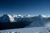
Climbing involves mostly walking on snow slopes up to 35 degrees, but there is one section of about 100m of steep ice. Views from the mountain are superb, encompassing many of the other well known mountains of the Cordillera Blanca, such as Huascarán
, Chopicalqui
, Artesonraju
, and Alpamayo
.
The altitude
makes the climb very difficult for anyone not well acclimatised or fit, and even those who are will be slowed down. Sleeping at the two high camps is also difficult. Possible sleeping in the third camp on the ice requires proper equipment.
Mountain
Image:Himalaya_annotated.jpg|thumb|right|The Himalayan mountain range with Mount Everestrect 58 14 160 49 Chomo Lonzorect 200 28 335 52 Makalurect 378 24 566 45 Mount Everestrect 188 581 920 656 Tibetan Plateaurect 250 406 340 427 Rong River...
in Peru
Peru
Peru , officially the Republic of Peru , is a country in western South America. It is bordered on the north by Ecuador and Colombia, on the east by Brazil, on the southeast by Bolivia, on the south by Chile, and on the west by the Pacific Ocean....
, located in the Cordillera Blanca
Cordillera Blanca
The Cordillera Blanca is a mountain range in the Ancash Region of Peru. Part of the larger Andes range, it includes 33 major peaks over high in an area wide and long.-Overview:...
about 60 km north of Huaraz
Huaraz
Huaraz is a city in Peru. It is the capital of the Departmento de Ancash and the seat of government of the Provincia de Huaraz . The urban agglomerations population is distributed over the districts of Huaraz and Independencia. It was estimated in 2007 to exceed 120,000...
. Nevado Pisco was first climbed on July 12, 1951 by C. Kojan, G.Kojan, R.Leininger and M. Lenoir.
Previously, this mountain was popular for its easy climb. However, the primary climbing route has melted significantly. As a result, this mountain is no longer the easy climb it once was and depending on the season Pisco has a large ice wall with a 50-60 metre climb up a 60 degree slope. It is now rated as PD on the French Alpine scale. It is predicted that this mountain will get more difficult as the glacier continues to recede.
There are a multitude of companies in Huaraz offering guided climbs of the mountain, which usually include all equipment, food, transport, guide, and possibly a porter. The normal route is from the road to the south, up to the col to the west, then to the summit. There are two or three camps on the mountain and one at its base, although climbers often only use one. The first is next to the road and river on the valley floor, known as Cebollapampa. The second is in or next to Refugio Perú (9°1′46.6"S 77°37′46.4"W at 4,765 m). The third, called the 'moraine camp' (9°1′24"S 77°38′31"W) lies just below the ice of the first glacier. It is also possible to set up a camp in the col right on the glacier, as there is a convenient flat part. Some parties travel from Huaraz and climb to the moraine camp in one day, then summit and return to Huaraz the next.
Climbing involves mostly walking on snow slopes up to 35 degrees, but there is one section of about 100m of steep ice. Views from the mountain are superb, encompassing many of the other well known mountains of the Cordillera Blanca, such as Huascarán
Huascarán
Huascarán or Nevado Huascarán is a mountain in the Peruvian province of Yungay, situated in the Cordillera Blanca range of the Western Andes. The highest southern summit of Huascarán is the highest point in Peru, and all the Earth's Tropics...
, Chopicalqui
Chopicalqui
Chopicalqui is a mountain in the Cordillera Blanca in the Andes of Peru. With a summit altitude of 6,354 meters above sea level, it is one of the Cordillera Blanca's highest peaks....
, Artesonraju
Artesonraju
Artesonraju is a peak in the Cordillera Blanca mountain range, a part of the Peruvian Andes, is also known as Arteson. To reach the lake there is a dirt road from Caraz which climbs +2000m along 32km in about 1:40 hours. At Pueblo Paron there's a check point and a gate, where visitors must pay...
, and Alpamayo
Alpamayo
Alpamayo is one of the most conspicuous peaks in the Cordillera Blanca mountain range of the Peruvian Andes.It is a steep , almost perfect pyramid of ice, one of a number of peaks that compose the Santa Cruz massif, the northernmost massif of the Cordillera Blanca...
.
The altitude
Altitude
Altitude or height is defined based on the context in which it is used . As a general definition, altitude is a distance measurement, usually in the vertical or "up" direction, between a reference datum and a point or object. The reference datum also often varies according to the context...
makes the climb very difficult for anyone not well acclimatised or fit, and even those who are will be slowed down. Sleeping at the two high camps is also difficult. Possible sleeping in the third camp on the ice requires proper equipment.
External links
- http://www.fedamon.com/revista/revista18/nevadopisco.htm (Spanish)
- Pisco on summitpost.org