

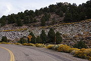
Nevada State Route 722
Encyclopedia
Churchill County, Nevada
Churchill County is a county located in the western U.S. state of Nevada. As of the 2000 census, the population was 23,982. As of July 1, 2007, the population of Churchill County was estimated at 27,190. The county, named after Mexican-American War hero brevet Brigadier General Sylvester Churchill,...
and Lander County
Lander County, Nevada
Lander County is a county located in the U.S. state of Nevada. As of the 2000 census, the population was 5,794. Its county seat is Battle Mountain.-History:...
in the U.S. state of Nevada
Nevada
Nevada is a state in the western, mountain west, and southwestern regions of the United States. With an area of and a population of about 2.7 million, it is the 7th-largest and 35th-most populous state. Over two-thirds of Nevada's people live in the Las Vegas metropolitan area, which contains its...
. The highway is an old routing of U.S. Route 50, and previously the Lincoln Highway
Lincoln Highway
The Lincoln Highway was the first road across the United States of America.Conceived and promoted by entrepreneur Carl G. Fisher, the Lincoln Highway spanned coast-to-coast from Times Square in New York City to Lincoln Park in San Francisco, originally through 13 states: New York, New Jersey,...
. What is now route 722 crosses the Desatoya Mountains
Desatoya Mountains
The Desatoya Mountains are located in central Nevada in the western United States, approximately 117 miles east of Reno by road. The range runs in a southwest-northeasterly direction along the border of Churchill and Lander Counties, reaching a maximum elevation of 9,973 feet at Desatoya Peak...
via Carroll Summit. The US 50 designation was removed from this alignment in favor of the modern route that traverses the Desatoya Mountains via New Pass Summit, which is 1100 feet (335.3 m) lower and with an easier approach on both sides than Carroll Summit.
Route description
SR 722 deviates from US 50 near the roadhouse at Middlegate. It then crosses 2 summits, Eastgate at 5110 feet (1,558 m), and Carroll Summit at 7492 feet (2,284 m). There is a small settlement at EastgateEastgate, Nevada
Eastgate is an unincorporated community located within Churchill County, Nevada, United States. It is located on the Lincoln Highway. The community's elevation is . Other alternate unofficial names include East Gate, Eastgate Station, and Gibralter Gate....
. On the west approach to Carroll is an old, unmaintained rest area
Rest area
A rest area, travel plaza, rest stop, or service area is a public facility, located next to a large thoroughfare such as a highway, expressway, or freeway at which drivers and passengers can rest, eat, or refuel without exiting on to secondary roads...
. The highway then traverses a long desert valley named Smith Creek Valley and another summit, Railroad Pass at 6431 feet (1,960 m), before entering the Reese River
Reese River
The Reese River is a tributary of the Humboldt River, located in central Nevada in the western United States. It rises in the southern section of the Toiyabe Range, on the flanks of Arc Dome...
valley where the highway reunites with US 50 just west of Austin.
History
As a dirt road, the routing of the Lincoln HighwayLincoln Highway
The Lincoln Highway was the first road across the United States of America.Conceived and promoted by entrepreneur Carl G. Fisher, the Lincoln Highway spanned coast-to-coast from Times Square in New York City to Lincoln Park in San Francisco, originally through 13 states: New York, New Jersey,...
across Nevada changed several times. The original route of the Pony Express
Pony Express
The Pony Express was a fast mail service crossing the Great Plains, the Rocky Mountains, and the High Sierra from St. Joseph, Missouri, to Sacramento, California, from April 3, 1860 to October 1861...
, from which the Nevada portion of the Lincoln Highway was based, crossed the Desatoya range at Basque Summit, at 7452 feet (2,271.4 m). The route used an alignment that is now a dirt road called "Old Overland Road". At one time the Lincoln Highway was routed on a route similar to the modern US 50 between Middlegate and Austin via New Pass.
The highway now numbered 722 was first constructed in 1924–1925 as part of improvements to the Lincoln Highway
Lincoln Highway
The Lincoln Highway was the first road across the United States of America.Conceived and promoted by entrepreneur Carl G. Fisher, the Lincoln Highway spanned coast-to-coast from Times Square in New York City to Lincoln Park in San Francisco, originally through 13 states: New York, New Jersey,...
. The intent was to shorten the route by 15 miles (24.1 km). While the route over Carroll Summit and Railroad Pass was shorter and more scenic, efforts began to revert to the New Pass Route as early as the 1930s. The route over New Pass Summit was being paved by 1967 and US 50 was re-routed back over New Pass Summit once finished.
Major intersections
- Note: Mileposts in Nevada reset at county lines.
County Mile Junction Notes County State Churchill Churchill County, NevadaChurchill County is a county located in the western U.S. state of Nevada. As of the 2000 census, the population was 23,982. As of July 1, 2007, the population of Churchill County was estimated at 27,190. The county, named after Mexican-American War hero brevet Brigadier General Sylvester Churchill,...0.000 0.000 Ione Ione, NevadaIone, Nevada is an unincorporated community in Nye County, Nevada, located approximately 23 miles east of Gabbs, Nevada. Current services include one grocery store....
Road16.616 16.616 Carroll Summit Desatoya MountainsThe Desatoya Mountains are located in central Nevada in the western United States, approximately 117 miles east of Reno by road. The range runs in a southwest-northeasterly direction along the border of Churchill and Lander Counties, reaching a maximum elevation of 9,973 feet at Desatoya Peak...County line Lander Lander County, NevadaLander County is a county located in the U.S. state of Nevada. As of the 2000 census, the population was 5,794. Its county seat is Battle Mountain.-History:...12.000 28.616 Reese River Agricultural District Reese RiverThe Reese River is a tributary of the Humboldt River, located in central Nevada in the western United States. It rises in the southern section of the Toiyabe Range, on the flanks of Arc Dome...41.523 58.139