
Nevada State Route 398
Encyclopedia
State Route 398 is a state highway in Pershing County
, Nevada
serving the city of Lovelock
. Part of the highway is former State Route 66.
 State Route 398 begins at interchange 106 with Interstate 80 (and concurrent
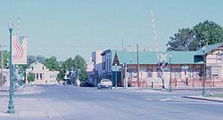
U.S. Route 95) near the center of Lovelock. From here, the highway heads northwest under the freeway on Main Street towards the town. After crossing the Union Pacific Railroad
tracks, the route intersects Cornell Avenue (I-80 Bus.) at the center of the city. Main Street at the intersection of Central Avenue at the steps to the Pershing County Courthouse
; SR 398, however, follows Central Avenue through residential areas of the city.
Exiting the city limits of Lovelock north of 16th Street, SR 398 becomes North Meridian Road. As the two-lane highway continues northward, houses gradually disappear in favor of the farm tracts of Upper Valley. The highway intersects Fairview Road, which it follows eastward. State Route 398 comes to an end at an intersection with Upper Valley Road (SR 396) northeast of Lovelock.
 The north–south segment of present-day State Route 398 appears on maps as early as 1937 in the form of State Route 66. SR 66 ran from State Route 1/U.S. Route 40 (now SR 396) approximately 2.5 miles (4 km) to its terminus at Fairview Road. SR 66 appears to have remained unchanged until the 1976 renumbering of Nevada's state highways on July 1, 1976. At that time, the highway was renumbered as State Route 398. The Fairview Road segment was likely added to the route during that process.
Pershing County, Nevada
Pershing County is a county located in the U.S. state of Nevada. As of the 2000 census, the population was 6,693. Its county seat is Lovelock. The county was named after army general John J. Pershing . It was formed from Humboldt County in 1919, and the last county to be established in...
, Nevada
Nevada
Nevada is a state in the western, mountain west, and southwestern regions of the United States. With an area of and a population of about 2.7 million, it is the 7th-largest and 35th-most populous state. Over two-thirds of Nevada's people live in the Las Vegas metropolitan area, which contains its...
serving the city of Lovelock
Lovelock, Nevada
Lovelock is a city in western Nevada that is the county seat of Pershing County, the location of a prison, and the namesake of the area's Cold War gunnery range...
. Part of the highway is former State Route 66.
Route description
Concurrency (road)
A concurrency, overlap, or coincidence in a road network is an instance of one physical road bearing two or more different highway, motorway, or other route numbers...
U.S. Route 95) near the center of Lovelock. From here, the highway heads northwest under the freeway on Main Street towards the town. After crossing the Union Pacific Railroad
Union Pacific Railroad
The Union Pacific Railroad , headquartered in Omaha, Nebraska, is the largest railroad network in the United States. James R. Young is president, CEO and Chairman....
tracks, the route intersects Cornell Avenue (I-80 Bus.) at the center of the city. Main Street at the intersection of Central Avenue at the steps to the Pershing County Courthouse
Pershing County Courthouse
The Pershing County Courthouse in Lovelock, Nevada is a Classical Revival building built in 1920-21. The courthouse's plan is hexagonal with a circular dome over the central circular courtroom. The building was designed by Frederic Joseph DeLongchamps, who had previously designed six other Nevada...
; SR 398, however, follows Central Avenue through residential areas of the city.
Exiting the city limits of Lovelock north of 16th Street, SR 398 becomes North Meridian Road. As the two-lane highway continues northward, houses gradually disappear in favor of the farm tracts of Upper Valley. The highway intersects Fairview Road, which it follows eastward. State Route 398 comes to an end at an intersection with Upper Valley Road (SR 396) northeast of Lovelock.
History