Nevada State Route 342
Encyclopedia
State highway
State highway, state road or state route can refer to one of three related concepts, two of them related to a state or provincial government in a country that is divided into states or provinces :#A...
in Nevada
Nevada
Nevada is a state in the western, mountain west, and southwestern regions of the United States. With an area of and a population of about 2.7 million, it is the 7th-largest and 35th-most populous state. Over two-thirds of Nevada's people live in the Las Vegas metropolitan area, which contains its...
, USA. It is a loop route of State Route 341
Nevada State Route 341
State Route 341 is a state highway in western Nevada connecting US 50 near Dayton to Reno via Virginia City. Commonly known as the Virginia City Highway, or Geiger Grade north of Virginia City, the route has origins dating back to the 1860s.-Route description:Nevada State Route 341 begins at a...
, running north through the communities of Silver City
Silver City, Nevada
Silver City is a town in Lyon County, Nevada, USA, near the Lyon/Carson border. The population as of the 2000 census was 170....
and Gold Hill
Gold Hill, Nevada
Gold Hill is a community in Storey County, Nevada, located just south and downhill of Virginia City. Incorporated December 17, 1862, in order to prevent its annexation by its larger neighbor, the town at one point was home to at least 8,000 residents. Prosperity was sustained for a period of 20...
before returning to State Route 341 near Virginia City
Virginia City, Nevada
Virginia City is a census-designated place that is the county seat of Storey County, Nevada. It is part of the Reno–Sparks Metropolitan Statistical Area. The population was 855 at the 2010 Census.- History :...
. This highway is a historic route, dating back to the Comstock Lode
Comstock Lode
The Comstock Lode was the first major U.S. discovery of silver ore, located under what is now Virginia City, Nevada, on the eastern slope of Mount Davidson, a peak in the Virginia Range. After the discovery was made public in 1859, prospectors rushed to the area and scrambled to stake their claims...
of the 1860s. The highway loosely parallels, and crosses, the route of the Virginia and Truckee Railroad
Virginia and Truckee Railroad
The Virginia and Truckee Railroad was built to serve the Comstock Lode mining communities of northwestern Nevada. At its height, the railroad's route ran from Reno south to Carson City, Nevada. In Carson City, the...
. Prior to renumbering in the 1970s this route was known as State Route 80.
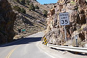
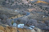
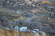
Route description
This is the original and shorter of the two routes between Silver City and Virginia City. However, trucks are required to use newer alignment (SR 341) due to 15% grades and hairpin curves. The route begins just south of Gold Hill, at the junction with SR 341. Both routes have Virginia City listed as the first control cityControl city
A control city is a city or locality posted on a traffic sign indicating forward destinations on a certain route. These destinations aid motorists using the highway system to reach destinations along the various routes...
, however all trucks are directed to use SR 341 instead of SR 342. The highway runs through narrow Gold Canyon for its entire length. This highway serves as the main street of Gold Hill and Silver City. While in Silver City the highway crosses the Virginia and Truckee Railroad
Virginia and Truckee Railroad
The Virginia and Truckee Railroad was built to serve the Comstock Lode mining communities of northwestern Nevada. At its height, the railroad's route ran from Reno south to Carson City, Nevada. In Carson City, the...
, now a heritage railroad that once served as a primary route to transport silver from the mines in Virginia City.
History
This highway was the principal highway between Virginia City and Carson CityCarson City, Nevada
The Consolidated Municipality of Carson City is the capital of the state of Nevada. The words Consolidated Municipality refer to a series of changes in 1969 which abolished Ormsby County and merged all the settlements contained within its borders into Carson City. Since that time Carson City has...
, and has been in use since the Comstock Lode
Comstock Lode
The Comstock Lode was the first major U.S. discovery of silver ore, located under what is now Virginia City, Nevada, on the eastern slope of Mount Davidson, a peak in the Virginia Range. After the discovery was made public in 1859, prospectors rushed to the area and scrambled to stake their claims...
of the 1860s. The highway has appeared on Nevada highway maps since at least as far back as 1919 and was first numbered part of Nevada State Route 17 (modern State Route 341
Nevada State Route 341
State Route 341 is a state highway in western Nevada connecting US 50 near Dayton to Reno via Virginia City. Commonly known as the Virginia City Highway, or Geiger Grade north of Virginia City, the route has origins dating back to the 1860s.-Route description:Nevada State Route 341 begins at a...
) sometime in the 1920s. The 1937 edition of the official Nevada Highway Map was the first to show both routes between Virginia City and Silver City, with both routes numbered 17. The 1949 edition showed separate numbers for the two routes, with the older route now numbered 80. It retained the 80 designation at least to 1979, before being renumbered route 342.
Major intersections