

Esmeralda County, Nevada
Encyclopedia
Esmeralda County is a county in the west of U.S. state
of Nevada
. Its county seat
is Goldfield
. Its 2000 census population was officially 971, making its population density
0.1045 inhabitants/km² (0.2706/sq mi), the second-lowest (to Loving County, Texas
) of any county-equivalent
outside of Alaska. As of 2010, the population had decreased to 783 people. Its school district
has no high school.
". An early Nevada miner, J. M. Corey, named the Esmeralda Mining District after the gypsy dancer, Esmeralda, from Victor Hugo
's novel, The Hunchback of Notre Dame
.
Esmeralda has had three county seats: Aurora
until 1883, Hawthorne
from 1883 to 1907 and finally Goldfield. At one point, due to the disputed border with California, Aurora was simultaneously the county seat
of both Mono County, California and Esmeralda County, Nevada. Samuel Clemens (Mark Twain
) wrote about his time as a miner in the Esmeralda District in his book Roughing It
.
Esmeralda grew from a gold
mining boom in the first years of the 20th century. The mines were largely tapped out by the end of the 1910s and the economy and population declined afterwards.
, the county has a total area of 3589 square miles (9,295.5 km²), virtually all of which is land. A very small part of Death Valley National Park
lies in its southeast corner.
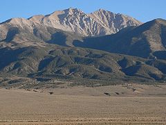
The county is dominated by the Silver Peak
and Monte Cristo
mountain ranges. Mountains in the county include:
, Auditor/Recorder, District Attorney
, Sheriff
, Justice of the Peace
, Treasurer
, District Court
, and Commissioner are located in the building.
has three elementary schools that currently serve approximately 90 students.
of 2000, there were 971 people, 455 households, and 259 families residing in the county. The population density
was 0 people per square mile (0/km²). There were 833 housing units at an average density of 0 per square mile (0/km²). The racial makeup of the county was 81.98% White
, 0.10% Black
or African American
, 5.15% Native American
, 0.21% Pacific Islander
, 7.62% from other races
, and 4.94% from two or more races. 10.20% of the population were Hispanic
or Latino
of any race.
There were 455 households out of which 21.10% had children under the age of 18 living with them, 46.40% were married couples
living together, 6.40% had a female householder with no husband present, and 42.90% were non-families. 36.00% of all households were made up of individuals and 13.20% had someone living alone who was 65 years of age or older. The average household size was 2.12 and the average family size was 2.79.
In the county, the population was spread out with 20.50% under the age of 18, 6.00% from 18 to 24, 23.40% from 25 to 44, 33.00% from 45 to 64, and 17.20% who were 65 years of age or older. The median age was 45 years. For every 100 females there were 123.70 males. For every 100 females age 18 and over, there were 118.70 males.
The median income for a household in the county was $33,203, and the median income for a family was $40,917. Males had a median income of $39,327 versus $25,469 for females. The per capita income
for the county was $18,971. 15.30% of the population and 7.50% of families were below the poverty line. Out of the total people living in poverty, 9.70% are under the age of 18 and 11.40% are 65 or older.
U.S. state
A U.S. state is any one of the 50 federated states of the United States of America that share sovereignty with the federal government. Because of this shared sovereignty, an American is a citizen both of the federal entity and of his or her state of domicile. Four states use the official title of...
of Nevada
Nevada
Nevada is a state in the western, mountain west, and southwestern regions of the United States. With an area of and a population of about 2.7 million, it is the 7th-largest and 35th-most populous state. Over two-thirds of Nevada's people live in the Las Vegas metropolitan area, which contains its...
. Its county seat
County seat
A county seat is an administrative center, or seat of government, for a county or civil parish. The term is primarily used in the United States....
is Goldfield
Goldfield, Nevada
Goldfield is an unincorporated community and the county seat of Esmeralda County, Nevada, United States, with a resident population of 440 at the 2000 census. It is located about southeast of Carson City, along U.S...
. Its 2000 census population was officially 971, making its population density
Population density
Population density is a measurement of population per unit area or unit volume. It is frequently applied to living organisms, and particularly to humans...
0.1045 inhabitants/km² (0.2706/sq mi), the second-lowest (to Loving County, Texas
Loving County, Texas
US Census 2000Of the 67 residents, 60 were White, 6 of "some other race", and 1 person of two or more races. There were 7 residents who were Hispanic or Latino of any race...
) of any county-equivalent
County-equivalent
A county-equivalent in the United States is a term used by the federal government to describe one of the two following governmental subdivisions:#A unit of local government in certain states which is comparable to a county as found in most states....
outside of Alaska. As of 2010, the population had decreased to 783 people. Its school district
Esmeralda County School District
Esmeralda County School District provides public education in Esmeralda County, Nevada. It is the smallest school district in Nevada. However, there are several smaller school districts in the United States, such as those in rural Montana and Alaska. In the 2004-2005 school year, the district had...
has no high school.
History
Esmeralda County is one of the original counties in Nevada, established in 1861. Esmeralda is the Spanish and Portuguese word for "emeraldEmerald
Emerald is a variety of the mineral beryl colored green by trace amounts of chromium and sometimes vanadium. Beryl has a hardness of 7.5–8 on the 10 point Mohs scale of mineral hardness...
". An early Nevada miner, J. M. Corey, named the Esmeralda Mining District after the gypsy dancer, Esmeralda, from Victor Hugo
Victor Hugo
Victor-Marie Hugo was a Frenchpoet, playwright, novelist, essayist, visual artist, statesman, human rights activist and exponent of the Romantic movement in France....
's novel, The Hunchback of Notre Dame
The Hunchback of Notre Dame
The Hunchback of Notre-Dame is a novel by Victor Hugo published in 1831. The French title refers to the Notre Dame Cathedral in Paris, on which the story is centered.-Background:...
.
Esmeralda has had three county seats: Aurora
Aurora, Nevada
Aurora is a ghost town in Mineral County in the western central part of the U.S. state of Nevada, approximately southwest of the town of Hawthorne and three miles from the California border....
until 1883, Hawthorne
Hawthorne, Nevada
Hawthorne is a census-designated place in Mineral County, Nevada, United States. The population was 3,311 at the 2000 census. It is the county seat of Mineral County...
from 1883 to 1907 and finally Goldfield. At one point, due to the disputed border with California, Aurora was simultaneously the county seat
County seat
A county seat is an administrative center, or seat of government, for a county or civil parish. The term is primarily used in the United States....
of both Mono County, California and Esmeralda County, Nevada. Samuel Clemens (Mark Twain
Mark Twain
Samuel Langhorne Clemens , better known by his pen name Mark Twain, was an American author and humorist...
) wrote about his time as a miner in the Esmeralda District in his book Roughing It
Roughing It
Roughing It is a book of semi-autobiographical travel literature written by American humorist Mark Twain. It was written during 1870–71 and published in 1872 as a prequel to his first book Innocents Abroad...
.
Esmeralda grew from a gold
Gold
Gold is a chemical element with the symbol Au and an atomic number of 79. Gold is a dense, soft, shiny, malleable and ductile metal. Pure gold has a bright yellow color and luster traditionally considered attractive, which it maintains without oxidizing in air or water. Chemically, gold is a...
mining boom in the first years of the 20th century. The mines were largely tapped out by the end of the 1910s and the economy and population declined afterwards.
Geography
According to the U.S. Census BureauUnited States Census Bureau
The United States Census Bureau is the government agency that is responsible for the United States Census. It also gathers other national demographic and economic data...
, the county has a total area of 3589 square miles (9,295.5 km²), virtually all of which is land. A very small part of Death Valley National Park
Death Valley National Park
Death Valley National Park is a national park in the U.S. states of California and Nevada located east of the Sierra Nevada in the arid Great Basin of the United States. The park protects the northwest corner of the Mojave Desert and contains a diverse desert environment of salt-flats, sand dunes,...
lies in its southeast corner.
The county is dominated by the Silver Peak
Silver Peak Range
The Silver Peak Range is a mountain range in southwest Esmeralda County, Nevada.-Geography:The Range forms the east and southeast side of Fish Lake Valley. The towering White Mountains lie across the valley to the west and southwest. The Palmetto Mountains are to the south.Piper Peak, Red Mountain,...
and Monte Cristo
Monte Cristo Range
The Monte Cristo Range is located in western Nevada in the United States. The range lies southeast of the Excelsior Mountains and east and north of Highway 95 in Esmeralda County...
mountain ranges. Mountains in the county include:
- Boundary PeakBoundary Peak (Nevada)Boundary Peak is the highest summit in U. S. state of Nevada and is located in Esmeralda County. It is the northernmost peak over 13,000 feet in the White Mountains. At the peak is within the state of Nevada, although it is only about half a mile from the California border...
, 13,147 feet (4,007 m), the highest natural point in Nevada - Piper Peak, 9450 feet (2,880 m)
- Magruder Mountain 9044 feet (2,756 m)
- Montezuma Peak, 8373 feet (2,552 m)
- Emigrant Peak, 6790 feet (2,069 m)
Major highways
 U.S. Route 95
 U.S. Route 6
- State Route 264
- State Route 266
 State Route 773Nevada State Route 773State Route 773 is a state highway in Esmeralda County, Nevada, USA. Known as Fish Lake Valley Road, the highway was a part of former State Route 3A.-Route description:...
Adjacent counties
- Mineral CountyMineral County, NevadaMineral County is a county located in the U.S. state of Nevada. As of the 2000 census, the population was 5,071. In 2009, it was estimated to have dropped to 4,662. Its county seat is Hawthorne.-History:...
- northwest - Nye CountyNye County, Nevada-National protected areas:* Ash Meadows National Wildlife Refuge* Death Valley National Park * Humboldt-Toiyabe National Forest * Spring Mountains National Recreation Area -Demographics:...
- east and north - Inyo County, CaliforniaInyo County, California-National protected areas:* Death Valley National Park * Inyo National Forest * Manzanar National Historic Site-Major highways:* U.S. Route 6* U.S. Route 395* State Route 127* State Route 136* State Route 168* State Route 178...
- south - Mono County, CaliforniaMono County, CaliforniaMono County is a county located in the east central portion of the U.S. state of California, to the east of the Sierra Nevada between Yosemite National Park and Nevada. As of the 2010 census, the population was 14,202, up from 12,853 at the 2000 census...
- west
National protected areas
- Death Valley National ParkDeath Valley National ParkDeath Valley National Park is a national park in the U.S. states of California and Nevada located east of the Sierra Nevada in the arid Great Basin of the United States. The park protects the northwest corner of the Mojave Desert and contains a diverse desert environment of salt-flats, sand dunes,...
(part) - Inyo National ForestInyo National ForestInyo National Forest is a federally administered forest in the United States. The forest covers parts of the eastern Sierra Nevada of California, and the White Mountains of California and Nevada. It contains two wilderness areas: the John Muir Wilderness and the Ansel Adams Wilderness...
(part)
Law and government
The county seat of Esmeralda County is Goldfield. It was moved to Goldfield on May 1, 1907. The courthouse was opened on May 1, 1908 and has been in continuous use since then. Currently, the Offices of the AssessorAssessor (property)
An assessor is a specialist who calculates the value of property. The value calculated by the assessor is then used as the basis for determining the amounts to be paid or assessed for tax or insurance purposes....
, Auditor/Recorder, District Attorney
District attorney
In many jurisdictions in the United States, a District Attorney is an elected or appointed government official who represents the government in the prosecution of criminal offenses. The district attorney is the highest officeholder in the jurisdiction's legal department and supervises a staff of...
, Sheriff
Sheriff
A sheriff is in principle a legal official with responsibility for a county. In practice, the specific combination of legal, political, and ceremonial duties of a sheriff varies greatly from country to country....
, Justice of the Peace
Justice of the Peace
A justice of the peace is a puisne judicial officer elected or appointed by means of a commission to keep the peace. Depending on the jurisdiction, they might dispense summary justice or merely deal with local administrative applications in common law jurisdictions...
, Treasurer
Treasurer
A treasurer is the person responsible for running the treasury of an organization. The adjective for a treasurer is normally "tresorial". The adjective "treasurial" normally means pertaining to a treasury, rather than the treasurer.-Government:...
, District Court
Nevada District Courts
The Nevada District Courts are the trial courts of general jurisdiction in the Nevada state court system.In the District Courts "criminal, civil, family, and juvenile matters are generally resolved through arbitration, mediation, and bench or jury trials."...
, and Commissioner are located in the building.
Education
The Esmeralda County School DistrictEsmeralda County School District
Esmeralda County School District provides public education in Esmeralda County, Nevada. It is the smallest school district in Nevada. However, there are several smaller school districts in the United States, such as those in rural Montana and Alaska. In the 2004-2005 school year, the district had...
has three elementary schools that currently serve approximately 90 students.
Demographics
As of the censusCensus
A census is the procedure of systematically acquiring and recording information about the members of a given population. It is a regularly occurring and official count of a particular population. The term is used mostly in connection with national population and housing censuses; other common...
of 2000, there were 971 people, 455 households, and 259 families residing in the county. The population density
Population density
Population density is a measurement of population per unit area or unit volume. It is frequently applied to living organisms, and particularly to humans...
was 0 people per square mile (0/km²). There were 833 housing units at an average density of 0 per square mile (0/km²). The racial makeup of the county was 81.98% White
Race (United States Census)
Race and ethnicity in the United States Census, as defined by the Federal Office of Management and Budget and the United States Census Bureau, are self-identification data items in which residents choose the race or races with which they most closely identify, and indicate whether or not they are...
, 0.10% Black
Race (United States Census)
Race and ethnicity in the United States Census, as defined by the Federal Office of Management and Budget and the United States Census Bureau, are self-identification data items in which residents choose the race or races with which they most closely identify, and indicate whether or not they are...
or African American
Race (United States Census)
Race and ethnicity in the United States Census, as defined by the Federal Office of Management and Budget and the United States Census Bureau, are self-identification data items in which residents choose the race or races with which they most closely identify, and indicate whether or not they are...
, 5.15% Native American
Race (United States Census)
Race and ethnicity in the United States Census, as defined by the Federal Office of Management and Budget and the United States Census Bureau, are self-identification data items in which residents choose the race or races with which they most closely identify, and indicate whether or not they are...
, 0.21% Pacific Islander
Race (United States Census)
Race and ethnicity in the United States Census, as defined by the Federal Office of Management and Budget and the United States Census Bureau, are self-identification data items in which residents choose the race or races with which they most closely identify, and indicate whether or not they are...
, 7.62% from other races
Race (United States Census)
Race and ethnicity in the United States Census, as defined by the Federal Office of Management and Budget and the United States Census Bureau, are self-identification data items in which residents choose the race or races with which they most closely identify, and indicate whether or not they are...
, and 4.94% from two or more races. 10.20% of the population were Hispanic
Race (United States Census)
Race and ethnicity in the United States Census, as defined by the Federal Office of Management and Budget and the United States Census Bureau, are self-identification data items in which residents choose the race or races with which they most closely identify, and indicate whether or not they are...
or Latino
Race (United States Census)
Race and ethnicity in the United States Census, as defined by the Federal Office of Management and Budget and the United States Census Bureau, are self-identification data items in which residents choose the race or races with which they most closely identify, and indicate whether or not they are...
of any race.
There were 455 households out of which 21.10% had children under the age of 18 living with them, 46.40% were married couples
Marriage
Marriage is a social union or legal contract between people that creates kinship. It is an institution in which interpersonal relationships, usually intimate and sexual, are acknowledged in a variety of ways, depending on the culture or subculture in which it is found...
living together, 6.40% had a female householder with no husband present, and 42.90% were non-families. 36.00% of all households were made up of individuals and 13.20% had someone living alone who was 65 years of age or older. The average household size was 2.12 and the average family size was 2.79.
In the county, the population was spread out with 20.50% under the age of 18, 6.00% from 18 to 24, 23.40% from 25 to 44, 33.00% from 45 to 64, and 17.20% who were 65 years of age or older. The median age was 45 years. For every 100 females there were 123.70 males. For every 100 females age 18 and over, there were 118.70 males.
The median income for a household in the county was $33,203, and the median income for a family was $40,917. Males had a median income of $39,327 versus $25,469 for females. The per capita income
Per capita income
Per capita income or income per person is a measure of mean income within an economic aggregate, such as a country or city. It is calculated by taking a measure of all sources of income in the aggregate and dividing it by the total population...
for the county was $18,971. 15.30% of the population and 7.50% of families were below the poverty line. Out of the total people living in poverty, 9.70% are under the age of 18 and 11.40% are 65 or older.
Cities and towns
- BlairBlair, Nevada-History:Today a historical marker commemorates Blair along State Route 265 just north of Silver Peak. At one time Blair was a thriving, albeit short-lived, mining boom town. As mining reached a fever pitch in Nevada during the Tonopah boom, the effects spidered out in all directions to revive many...
, a ghost townGhost townA ghost town is an abandoned town or city. A town often becomes a ghost town because the economic activity that supported it has failed, or due to natural or human-caused disasters such as floods, government actions, uncontrolled lawlessness, war, or nuclear disasters... - CoaldaleCoaldale, NevadaCoaldale is a ghost town in Esmeralda County, Nevada. There is reportedly also a community with the same name in Nye County, Nevada. Coaldale had a store, cafe, motel, and service station as late as 1993, but is now abandoned.- External links :*...
, a ghost townGhost townA ghost town is an abandoned town or city. A town often becomes a ghost town because the economic activity that supported it has failed, or due to natural or human-caused disasters such as floods, government actions, uncontrolled lawlessness, war, or nuclear disasters... - GoldfieldGoldfield, NevadaGoldfield is an unincorporated community and the county seat of Esmeralda County, Nevada, United States, with a resident population of 440 at the 2000 census. It is located about southeast of Carson City, along U.S...
- DyerDyer, NevadaDyer is a small village in Esmeralda County, Nevada with a population of 110 as of the 2000 census. Dyer is located on State Route 264, near Nevada's border with California in the Fish Lake Valley. Air transportation is available at Dyer Airport....
- LidaLida, NevadaLida, Nevada is a small town in Esmeralda County, Nevada, near the border with California. It is located on State Route 266, north of Magruder Mountain....
, a ghost townGhost townA ghost town is an abandoned town or city. A town often becomes a ghost town because the economic activity that supported it has failed, or due to natural or human-caused disasters such as floods, government actions, uncontrolled lawlessness, war, or nuclear disasters... - Gold PointGold Point, NevadaGold Point, Nevada is a well preserved ghost town in Esmeralda County, Nevada.-History:The area that would become Gold Point was first settled by ranchers and a few miners during the 1880s...
, a ghost townGhost townA ghost town is an abandoned town or city. A town often becomes a ghost town because the economic activity that supported it has failed, or due to natural or human-caused disasters such as floods, government actions, uncontrolled lawlessness, war, or nuclear disasters... - PalmettoPalmetto, NevadaPalmetto, Nevada is an abandoned ghost town in Esmeralda County, in the U.S. state of Nevada. Palmetto was founded and established in 1866, the time when silver was found. Although the town was abandoned in a year, folks returned in 1906 when mines were reopened and several businesses started up as...
, a ghost townGhost townA ghost town is an abandoned town or city. A town often becomes a ghost town because the economic activity that supported it has failed, or due to natural or human-caused disasters such as floods, government actions, uncontrolled lawlessness, war, or nuclear disasters... - Silver PeakSilver Peak, NevadaSilver Peak is an unincorporated community in Esmeralda County, Nevada, United States. It lies along State Route 265 south of U.S. Route 6 and west of Goldfield, the county seat of Esmeralda County. Its elevation is 4,321 feet . Although it is unincorporated, it has a post office, with the...
See also
- National Register of Historic Places listings in Esmeralda County, Nevada
- USS Esmeraldo County (LST-761)USS Esmeraldo County (LST-761)USS Esmeraldo County was an built for the United States Navy during World War II. Named after an erroneous spelling of Esmeralda County, Nevada, she was the only U.S. Naval vessel to bear the name....
External links
- New Site: County of Esmeralda New Website
- Esmeralda County School District Website