

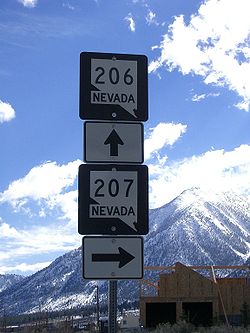
Nevada State Route 207
Encyclopedia
State Route 207 is a state highway in Douglas County
, Nevada
. Commonly known as the Kingsbury Grade, it is one of three Nevada highways that connects the western edge of the state to the Lake Tahoe
region. The route was part of State Route 19
prior to 1976.
 State Route 207 begins at a junction with U.S. Route 50
in Stateline
, less than 1 miles (1.6 km) from the California
state line near the southern shores of Lake Tahoe. From there, the route heads eastward on an uphill climb through the Kingsbury
area to travel through Daggett Pass (elevation 7344 feet (2,238.5 m)).
After exiting the pass, SR 207 continues its trek eastward through Toiyabe National Forest lands. It goes through several switchbacks, eventually turning southward as it descends the mountains. The road goes down an escarpment
to the Carson Valley floor. SR 207 comes to an end at its junction with Foothill Road (SR 206
), at the site of Mottsville
west of Gardnerville
.
and south to the California state line near Holbrook. This section of State Route 19 was 13 miles (20.9 km) long, about 9 miles (14.5 km) of which comprised the Kingsbury Grade portion of highway. SR 19 through the mountains remained unimproved for many years; the route was not paved until 1967. By 1968, the eastern end of the Kingsbury Grade was moved southwards to line up with what is now Mottsville Lane, mirroring the approximately 11 miles (17.7 km) alignment of the present highway.
Following the realignment, the Kingsbury Grade section of SR 19 was not altered until the 1976 renumbering of Nevada's state highway system on July 1, 1976. In that process, this portion of SR 19 was assigned to the new State Route 207. This change was first seen on state highway maps in 1978. Also included in the new State Route 207 was the 3 miles (4.8 km) section of Mottsville Lane which connects Kingsbury Grade to State Route 88
, making SR 207 about 14 miles (22.5 km) long; however, this section appears to have been removed from the route by 1983. The route has been largely unchanged since.
Douglas County, Nevada
Douglas County is a county located in the northwestern part of the U.S. state of Nevada. As of 2000, the population was 41,259. As of 2010, the population was estimated to be 46,997.- History :...
, Nevada
Nevada
Nevada is a state in the western, mountain west, and southwestern regions of the United States. With an area of and a population of about 2.7 million, it is the 7th-largest and 35th-most populous state. Over two-thirds of Nevada's people live in the Las Vegas metropolitan area, which contains its...
. Commonly known as the Kingsbury Grade, it is one of three Nevada highways that connects the western edge of the state to the Lake Tahoe
Lake Tahoe
Lake Tahoe is a large freshwater lake in the Sierra Nevada of the United States. At a surface elevation of , it is located along the border between California and Nevada, west of Carson City. Lake Tahoe is the largest alpine lake in North America. Its depth is , making it the USA's second-deepest...
region. The route was part of State Route 19
Nevada State Route 19
State Route 19 is a former state highway in Douglas County, Nevada. The route was designated by 1929. As designated, it connected a branch of State Route 3 near South Lake Tahoe to California southeast of Gardnerville near Topaz Lake.SR 19 followed the present-day alignment of State Routes 206, a...
prior to 1976.
Route description
U.S. Route 50 in Nevada
U.S. Route 50 is a transcontinental highway in the United States, stretching from Sacramento, California in the west to Ocean City, Maryland on the east coast. The Nevada portion crosses the center of state and was named The Loneliest Road in America by Life magazine in July 1986...
in Stateline
Stateline, Nevada
-Demographics:As of the census of 2000, there were 1,215 people, 510 households, and 245 families residing in the CDP. The population density was 1,803.3 people per square mile . There were 562 housing units at an average density of 834.1 per square mile...
, less than 1 miles (1.6 km) from the California
California
California is a state located on the West Coast of the United States. It is by far the most populous U.S. state, and the third-largest by land area...
state line near the southern shores of Lake Tahoe. From there, the route heads eastward on an uphill climb through the Kingsbury
Kingsbury, Nevada
Kingsbury is a census-designated place in Douglas County, Nevada, United States. The population was 2,624 at the 2000 census.-Geography:Kingsbury is located at ....
area to travel through Daggett Pass (elevation 7344 feet (2,238.5 m)).
After exiting the pass, SR 207 continues its trek eastward through Toiyabe National Forest lands. It goes through several switchbacks, eventually turning southward as it descends the mountains. The road goes down an escarpment
Escarpment
An escarpment is a steep slope or long cliff that occurs from erosion or faulting and separates two relatively level areas of differing elevations.-Description and variants:...
to the Carson Valley floor. SR 207 comes to an end at its junction with Foothill Road (SR 206
Nevada State Route 206
State Route 206 is a state highway in Douglas County, Nevada, United States. It runs northwest from State Route 88 near the California state line along Foothill Road to Genoa, and then turns east on Genoa Lane to end at U.S. Route 395.-History:...
), at the site of Mottsville
Mottsville, Nevada
Mottsville is an unincorporated community in Douglas County, Nevada, United States. Mottsville is located at the junction of Nevada State Route 206 and Nevada State Route 207 west-southwest of Minden....
west of Gardnerville
Gardnerville, Nevada
Gardnerville is a census-designated place in Douglas County, Nevada, United States, adjacent to the county seat of Minden. The population was 3,357 at the 2000 census....
.
History
A road connecting Lake Tahoe to the Carson Valley, situated in the approximate location of today's SR 207, appears on Nevada state maps as early as 1919. By 1929, this unimproved road was included in the state highway system as the northwestern end of State Route 19, a longer route stretching from Lake Tahoe through MindenMinden, Nevada
Minden is a census-designated place in Douglas County, Nevada, United States. The population was 2,836 at the 2000 census. It is the county seat of Douglas County and is adjacent to the city of Gardnerville. It is named after the town of Minden, in the German state of North Rhine-Westphalia. It...
and south to the California state line near Holbrook. This section of State Route 19 was 13 miles (20.9 km) long, about 9 miles (14.5 km) of which comprised the Kingsbury Grade portion of highway. SR 19 through the mountains remained unimproved for many years; the route was not paved until 1967. By 1968, the eastern end of the Kingsbury Grade was moved southwards to line up with what is now Mottsville Lane, mirroring the approximately 11 miles (17.7 km) alignment of the present highway.
Following the realignment, the Kingsbury Grade section of SR 19 was not altered until the 1976 renumbering of Nevada's state highway system on July 1, 1976. In that process, this portion of SR 19 was assigned to the new State Route 207. This change was first seen on state highway maps in 1978. Also included in the new State Route 207 was the 3 miles (4.8 km) section of Mottsville Lane which connects Kingsbury Grade to State Route 88
Nevada State Route 88
State Route 88 is a state highway in Douglas County, Nevada. It runs from California State Route 88 at the California state line along Woodfords Road to U.S. Route 395 in Minden. Prior to 1957, the highway existed as State Route 37...
, making SR 207 about 14 miles (22.5 km) long; however, this section appears to have been removed from the route by 1983. The route has been largely unchanged since.