

Nevada State Route 168
Encyclopedia
State Route 168 is a state highway
in Clark County
, Nevada
, USA. Also known as Glendale/Moapa Road, the highway connects Interstate 15 at Glendale
to U.S. Route 93 (US 93) 25 miles (40.2 km) northwest. The route was designated as the southern end of State Route 7 in 1919, and served as part of US 93 from 1931 to 1967.
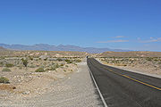 SR 168 begins at the Interstate 15 interchange (exit 90) in the town of Glendale in northern Clark County. From there, the highway heads westward about 2 miles (3.2 km) to enter the town of Moapa in the Moapa River Indian Reservation
. SR 168 continues west for 21 miles (33.8 km), passing north of the Arrow Canyon Wilderness Area. The highway ends at the junction with US 93 east of the Sheep Range
on the eastern border of the Desert National Wildlife Refuge
. A new master planned community, Coyote Springs
, is proposed to be constructed near the western terminus.
amended the general highway law to add State Route 7, which was vaguely defined as "commencing at the city of Ely
and running thence southerly through Pioche
to Las Vegas
." The southern terminus of SR 7 was later truncated to Glendale, with its southernmost miles following the alignment of present-day SR 168.
At a meeting held on June 8, 1931, the American Association of State Highway Officials (AASHO) approved an extension of U.S. Route 93
through Nevada. This extension brought the southern end of that route from Wells
to Glendale. South of Ely, the extension of US 93 was routed over State Route 7, including the portion northwest of Glendale. AASHO ordered another southerly extension of US 93 to Arizona via Las Vegas
in 1935, which was signed by 1939. The routing of US 93 via the Glendale–Moapa segment remained in place until 1967. In that year, a shorter route connecting Las Vegas and Caliente
was completed, bypassing Glendale. The 24 miles (38.6 km) of highway northwest of Glendale remained in the state highway system, still marked as State Route 7.
After the removal of US 93 from the route, the southerly segment of SR 7 remained unchanged for several years. On July 1, 1976, the Nevada Department of Transportation initiated the renumbering of Nevada's state highways. In this process, the highway was renumbered to State Route 168. This change was first seen on the 1978 edition of the state's highway map.
State highway
State highway, state road or state route can refer to one of three related concepts, two of them related to a state or provincial government in a country that is divided into states or provinces :#A...
in Clark County
Clark County, Nevada
-Demographics:As of the census of 2000, there were 1,375,765 people, 512,253 households, and 339,693 families residing within the MSA. The racial makeup of the MSA was 71.6% White , 9.1% Black, 5.7% Asian, 0.8% American Indian and 12.8% of other or mixed race. 22.0% were Hispanic of any race...
, Nevada
Nevada
Nevada is a state in the western, mountain west, and southwestern regions of the United States. With an area of and a population of about 2.7 million, it is the 7th-largest and 35th-most populous state. Over two-thirds of Nevada's people live in the Las Vegas metropolitan area, which contains its...
, USA. Also known as Glendale/Moapa Road, the highway connects Interstate 15 at Glendale
Glendale, Nevada
Glendale is an unincorporated community in Clark County, Nevada, United States. The community is an elevation of ....
to U.S. Route 93 (US 93) 25 miles (40.2 km) northwest. The route was designated as the southern end of State Route 7 in 1919, and served as part of US 93 from 1931 to 1967.
Route description
Moapa River Indian Reservation
Moapa River Indian Reservation is an Indian reservation located northeast of Las Vegas, near Moapa. It is the land-base for the Moapa Band of Paiute Indians, a local band of Southern Paiute Indians. Moapa River Indian Reservation consists of 71,954 acres .As of the year 2000, the population was 206...
. SR 168 continues west for 21 miles (33.8 km), passing north of the Arrow Canyon Wilderness Area. The highway ends at the junction with US 93 east of the Sheep Range
Sheep Range
The Sheep Range is located north of Las Vegas, Nevada in the United States. It is found in both Clark and Lincoln Counties in the Desert National Wildlife Refuge. The mountains reach a peak at Hayford Peak, above sea level between the Las Vegas Range to the east and the Desert Range to the west...
on the eastern border of the Desert National Wildlife Refuge
Desert National Wildlife Refuge
The Desert National Wildlife Range is a protected wildlife refuge, administered by the U.S. Fish and Wildlife Service, located north of Las Vegas, Nevada, in northwestern Clark and southwestern Lincoln counties, with much of its land area lying within the southeastern section of the Nevada Test and...
. A new master planned community, Coyote Springs
Coyote Springs, Nevada
Coyote Springs, Nevada, is a master-planned community being developed in Lincoln County and Clark County, Nevada, by developer and attorney-lobbyist Harvey Whittemore and Pardee Homes.-Current development:...
, is proposed to be constructed near the western terminus.
History
State Route 168 has existed as part of Nevada's state highway system since 1919. In that year, the Nevada LegislatureNevada Legislature
The Nevada Legislature is the state legislature of the U.S. state of Nevada. The Legislature is a bicameral body, consisting of the lower house Nevada Assembly, with 42 members, and the upper house Nevada Senate, with 21 members. All 63 members of the Legislature are elected from an equal amount of...
amended the general highway law to add State Route 7, which was vaguely defined as "commencing at the city of Ely
Ely, Nevada
Ely is the largest city and county seat of White Pine County, Nevada, United States. Ely was founded as a stagecoach station along the Pony Express and Central Overland Route. Ely's mining boom came later than the other towns along US 50, with the discovery of copper in 1906...
and running thence southerly through Pioche
Pioche, Nevada
-External links:*...
to Las Vegas
Las Vegas, Nevada
Las Vegas is the most populous city in the U.S. state of Nevada and is also the county seat of Clark County, Nevada. Las Vegas is an internationally renowned major resort city for gambling, shopping, and fine dining. The city bills itself as The Entertainment Capital of the World, and is famous...
." The southern terminus of SR 7 was later truncated to Glendale, with its southernmost miles following the alignment of present-day SR 168.
At a meeting held on June 8, 1931, the American Association of State Highway Officials (AASHO) approved an extension of U.S. Route 93
U.S. Route 93
U.S. Route 93 is a major north–south United States highway in the western United States. The southern terminus is at U.S. Route 60 in Wickenburg, Arizona. The northern terminus is at the Canadian border north of Eureka in Lincoln County, Montana, where the roadway continues into Roosville,...
through Nevada. This extension brought the southern end of that route from Wells
Wells, Nevada
Wells is a city in Elko County, in northeast Nevada in the western United States. The population was 1,346 at the 2000 census. Wells is located at the junction of U.S. Route 93 and Interstate 80, approximately east of Elko and is part of the Elko Micropolitan Statistical Area.-History:The site...
to Glendale. South of Ely, the extension of US 93 was routed over State Route 7, including the portion northwest of Glendale. AASHO ordered another southerly extension of US 93 to Arizona via Las Vegas
Las Vegas, Nevada
Las Vegas is the most populous city in the U.S. state of Nevada and is also the county seat of Clark County, Nevada. Las Vegas is an internationally renowned major resort city for gambling, shopping, and fine dining. The city bills itself as The Entertainment Capital of the World, and is famous...
in 1935, which was signed by 1939. The routing of US 93 via the Glendale–Moapa segment remained in place until 1967. In that year, a shorter route connecting Las Vegas and Caliente
Caliente, Nevada
Caliente , formerly known as Culverwell and Calientes is a town in Lincoln County, Nevada, United States. Its elevation is 4,300 feet . The population was 1,123 at the 2000 census...
was completed, bypassing Glendale. The 24 miles (38.6 km) of highway northwest of Glendale remained in the state highway system, still marked as State Route 7.
After the removal of US 93 from the route, the southerly segment of SR 7 remained unchanged for several years. On July 1, 1976, the Nevada Department of Transportation initiated the renumbering of Nevada's state highways. In this process, the highway was renumbered to State Route 168. This change was first seen on the 1978 edition of the state's highway map.