

Nevada State Route 164
Encyclopedia
State Route 164 is a state highway
in southern Clark County
, Nevada
. The route, along with an unnumbered California
road, connects U.S. Route 95
(US 95) in Nevada to Interstate 15
in California just south of Primm
, via the small town of Nipton, California
. The highway is also known as Nipton Road.
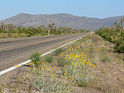
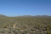 The route begins at the California-Nevada state line about 3 miles (4.8 km) east of Nipton. The highway treks east from there, curving slightly northeast to pass by the McCullough Range. At the northern tip of the mountains surrounding Crescent Peak, the highway turns slightly more southeast and decreases in elevation as it heads towards Searchlight, Nevada
. SR 164 reaches its eastern terminus at the junction with US 95 in the center of Searchlight; however, the roadway continues east as Cottonwood Cove Road, entering the Lake Mead National Recreation Area
and ending near Cottonwood Cove
.
In 2003, a sign near Searchlight designated the route as the Joshua Tree Highway, due to the abundance of Joshua tree
s located along the roadway.
 The highway connecting Searchlight to Nipton first appears on maps as a county road in 1933. By 1940, the unimproved road was designated State Route 68. The road had been graded by 1950 and was finally paved by 1963.
In 1976, the Nevada Department of Transportation
began a project to simplify and renumber the state highway system. During this process, the road was reassigned to State Route 164. The route has been largely unchanged since.
State highway
State highway, state road or state route can refer to one of three related concepts, two of them related to a state or provincial government in a country that is divided into states or provinces :#A...
in southern Clark County
Clark County, Nevada
-Demographics:As of the census of 2000, there were 1,375,765 people, 512,253 households, and 339,693 families residing within the MSA. The racial makeup of the MSA was 71.6% White , 9.1% Black, 5.7% Asian, 0.8% American Indian and 12.8% of other or mixed race. 22.0% were Hispanic of any race...
, Nevada
Nevada
Nevada is a state in the western, mountain west, and southwestern regions of the United States. With an area of and a population of about 2.7 million, it is the 7th-largest and 35th-most populous state. Over two-thirds of Nevada's people live in the Las Vegas metropolitan area, which contains its...
. The route, along with an unnumbered California
California
California is a state located on the West Coast of the United States. It is by far the most populous U.S. state, and the third-largest by land area...
road, connects U.S. Route 95
U.S. Route 95 in Nevada
In the U.S. state of Nevada, U.S. Route 95 is a major U.S. highway traversing the state from north to south directly through Las Vegas and providing connections to both Carson City and Reno...
(US 95) in Nevada to Interstate 15
Interstate 15 in California
In the U.S. state of California, Interstate 15 is a major north–south route through the San Bernardino, Riverside, and San Diego Counties, and it has a length of in the state. It is a major thoroughfare for traffic between Southern California and Las Vegas, Nevada, as well as points beyond...
in California just south of Primm
Primm, Nevada
Primm is a tiny community in Clark County, Nevada, United States, primarily notable for its position straddling Interstate 15 where it crosses the border between California and Nevada...
, via the small town of Nipton, California
Nipton, California
Nipton is an unincorporated town in San Bernardino County, California, on the northern edge of Mojave National Preserve, west of Searchlight, Nevada. It has a population of 20 people....
. The highway is also known as Nipton Road.
Route description
Searchlight, Nevada
Searchlight is an unincorporated town in Clark County, Nevada, at the topographic saddle between two mountain ranges.-History:According to Nevada Senator Harry Reid, who has written extensively about his hometown, the most likely story as to how the town received its name was when George Frederick...
. SR 164 reaches its eastern terminus at the junction with US 95 in the center of Searchlight; however, the roadway continues east as Cottonwood Cove Road, entering the Lake Mead National Recreation Area
Lake Mead National Recreation Area
Lake Mead National Recreation Area is located in southern Nevada and northwestern Arizona. The centerpieces of the National Recreation Area are its two large reservoirs: Lake Mead and Lake Mohave. These lakes cater to boaters, swimmers, sunbathers, and fishermen while the surrounding desert rewards...
and ending near Cottonwood Cove
Cottonwood Cove, Nevada
Cottonwood Cove is situated at the banks of Lake Mohave on the Nevada-Arizona border in Clark County, Nevada, United States. It stands just 13.1 miles and 23 minutes east of historic Searchlight, 12.5 miles north of Laughlin and an hour away from Las Vegas. It's the site of the Cottonwood Cove...
.
In 2003, a sign near Searchlight designated the route as the Joshua Tree Highway, due to the abundance of Joshua tree
Joshua tree
Yucca brevifolia is a plant species belonging to the genus Yucca. It is tree-like in habit, which is reflected in its common names: Joshua tree, Yucca palm, Tree yucca, and Palm tree yucca....
s located along the roadway.
History
In 1976, the Nevada Department of Transportation
Nevada Department of Transportation
The Nevada Department of Transportation is a government agency in the U.S. state of Nevada. NDOT is responsible for maintaining and improving Nevada's highway system, which includes U.S. highways and Interstate highways within the state's boundaries. The department is notable for its...
began a project to simplify and renumber the state highway system. During this process, the road was reassigned to State Route 164. The route has been largely unchanged since.