
Neighborhoods of Omaha, Nebraska
Encyclopedia
The neighborhoods of Omaha
are a diverse collection of community areas and specific enclaves. They are spread throughout the Omaha metro area
, and are all on the Nebraska side of the Missouri River
.
. In the early decades after settlement the city expanded, building the Near North Side
, Sheelytown (Irish immigrants), and housing districts throughout what is now Downtown Omaha
.
In the 1880s the next wave of development occurred where land was available at downtown's southern and western edges, including: Bemis Park
, Dahlman
, Deer Park, Dogtown, Gifford Park
, Hanscom Park
, and Kountze Place
and Little Bohemia
.
is a neighborhood of north-central Omaha near 60th and Maple Streets; it was annexed in 1917. Dundee
is a neighborhood in central Omaha near 50th and Dodge Street
s. Originally a separate city, Dundee was annexed
by Omaha in 1915, but the residents fought annexation in the courts until 1917. Elkhorn
takes its name from the Elkhorn River and was incorporated by an act of the territorial legislature
in 1856. It was annexed by Omaha on March 8, 2005 after a two-year court battle. Elkhorn became part of Omaha on March 1, 2007. The original town site is near 204th St. and West Maple Road in West Omaha.
Florence
is a neighborhood in far north Omaha. The original Mormon settlement in Florence, called Cutler's Park
, predated the founding of Omaha in 1846. Florence was annexed by Omaha in 1917. Hayes was a historic town located two miles from Bennington that evaporated in the 1870s, when the railroad failed to come to the town. Millard
is a broad area of southwest Omaha, originally a separate city and annexed in 1971. The original town site is near 132nd and Q Streets. Saratoga is a historic neighborhood in North Omaha. The town was founded, boomed and busted
within one year (1856-57). Its legacy includes a school, library and businesses still in the area.
s operate as suburbs of Omaha. The largest is Bellevue
, which may be the oldest settlement in Nebraska and is the state's third largest city. It is located just south of Omaha in eastern Sarpy County
. Bennington
was founded in the 1880s and was originally called "Bunz Town". Located northwest of the city, it was a key stop along the Fremont, Elkhorn, and Missouri Valley Railroad in the early 1900s. Carter Lake, Iowa
, which was formerly on the eastern side of the Missouri River
, today sits nestled into Nebraska. Irvington
was first named Pappio because of its location on Pappio Creek. The city is increasingly encroaching on this town in its northwestern corner. La Vista
is a city south of Omaha in north-central Sarpy County
. Papillion
is a city south of Omaha and immediately south of La Vista. It is the county seat of Sarpy County
. Ralston
is a city in south-central Douglas County
roughly bounded by 72nd, 84th, L, and Harrison Streets. It is surrounded by Omaha on three sides. The other side borders with La Vista. Valley
was established in 1865 and was an important shipping point along the Union Pacific Railroad
. Waterloo
was established in 1883 along the Elkhorn and Platte rivers and is west of Omaha.
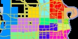
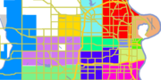 Omaha is split into several geographically designated areas, which cover several neighborhoods. Midtown is a racially diverse, historically rich area of Omaha immediately west of Downtown Omaha
. North Omaha
is a community area north of downtown Omaha with a rich historical
, architectural, and religious legacy, particularly for the city's African American
population. South Omaha
is a community area encompassing many neighborhoods south of downtown Omaha which historically has been home to Omaha’s Eastern European immigrant population, and more recently, Central and North American Hispanic immigrants. Churches and other structures reflect its rich past. Formerly a portion of this area was a separate city named South Omaha; it was annexed by Omaha in 1915. West Omaha
is the collective term for areas of the city west of 72nd Street, and the area of newer suburbs and community institutions, the next wave of historically significant buildings. Within that broad area there are several sub-community areas including Northwest Omaha, Southwest Omaha, Millard and Irvington. Also, much further to the west is the newly annexed community area/past city of Elkhorn
.
was a conspicuous development first platted in 1855 to award Nebraska Territory
legislators for the votes for statehood. It was bound by 16th street on the east, 24th on the west and Lake Street to the north. The area was developed quickly, and included a number of prominent homes. The land therein formed the nucleus of Near North Omaha. Near North Omaha became one of the most historically significant communities in Omaha, as it developed commercially and socially into the 20th century. The area was bound by downtown Omaha on the south and the Saratoga neighborhood on the north, 30th Street on the west and 16th Avenue on the east. Created by historical German, Irish, Jewish, and African Americans, the community became a renowned center of Black culture in the United States in the 1920s. From then through the 1960s, the area was dominated by black-owned businesses, churches and social centers. There were also a number of Jewish-owned businesses, as well. The area was the site of several riots in the 1960s, and decayed for the next 30 years. The Great Plains Black History Museum
was started there in 1976. Over the last 20 years a series of community restoration projects, including the demolition of the Logan Fontenelle Housing Projects and the creation of Dreamland Plaza, has sought to revitalize the community.
The Saratoga community is the location of a historical town that boomed and busted
within one year of its founding. Its legacy includes a school, library and businesses still in the area. Also in the area is Kountze Place
, a former suburban enclave of wealthy Omaha doctors, lawyers and businessmen. The northeast part of North Omaha, roughly defined by all areas north of Dodge Street and east of 16th Street, until Fort Street when Florence Boulevard
becomes the western boundary. The eastern boundary is the Missouri River
. Neighborhoods in this section of North Omaha include Carter Lake, Iowa
, East Omaha and Beechwood. Carter Lake was formerly on the eastern side of the Missouri River
. Originally part of the township of East Omaha, the community was ceded to the State of Iowa after a contentious court battle in the late 1890s. Omaha's Levi Carter Park
is located here. Beechwood was located near Florence Lake in East Omaha. Located next to the Missouri River and the now-dry Florence Lake, Beechwood had its own school district and commercial area. Today it is site of a trailer court by the same name. East Omaha proper was once an agricultural area. Once considered for the site of the Trans-Mississippi Exposition
, it lost out to Kountze Park
. Omaha's main airport, Eppley Airfield
, is now in East Omaha, and the community has been the location of racial contention for several years. East Omaha was the first annexation to the City of Omaha in 1854.
Far north Omaha includes everything north of Ames Avenue, west of Florence Boulevard, and east of 72nd Street. It includes Florence
, the original Mormon settlement of Cutler's Park
, which predates the founding of the City of Omaha; it was annexed in 1917. Miller Park
, a neighborhood named after Omaha pioneer Dr. George Miller, was primarily developed from 1920 to 1950, bound by 30th Street on the west and Florence Blvd on the east, Miller Park on the north and Sorenson Parkway on the south. It is the location of several churches, an elementary school and a park by the same name. Minne Lusa
is a neighborhood in far North Omaha primarily developed from 1915 and 1926, and bound by Miller Park on the south, Florence on the north, Florence Boulevard and Pershing Drive on the east, and 30th Street on the west. The southwest part of North Omaha includes Benson
, located near 60th and Maple Streets. Originally incorporated as a city in the 1880s, it was annexed to Omaha in 1917. Benson has several historic locations, and is an important neighborhood today. Next to Benson is Dundee
, near 50th and Dodge Streets. Originally a separate city, Dundee was annexed
by Omaha in 1915, but this annexation was fought until 1917. The Gold Coast
neighborhood, including St. Cecilia Cathedral
, has several important architectural gems, as well as several historical parks. Other important historical neighborhoods in this area include Gifford Park
, Orchard Hill
and Walnut Hill
.
The central area of Omaha, immediately west of downtown and extending to 72nd Street, is home to several of historically significant neighborhoods. Gifford Park
, Morton Meadows
, Gold Coast and Country Club are important to the history of Omaha. Bemis Park is centrally located, and is home to a number of architecturally significant homes and public works.
Located in West Omaha is Boys Town
, an incorporated village
near 132nd and Dodge Streets and is home to the famous institution of the same name. Also on the fringe of the city is Chalco
, an unincorporated area
southwest of Omaha in northern Sarpy County
that forms its own neighborhood.
South 24th Street
, Sheelytown, Little Bohemia
, Little Italy, Brown Park
, Dog Hollow, and Little Poland are all located throughout South Omaha. Spring Lake
and Deer Park are also located in the area, as well as Field Club and the Omaha Quartermaster Depot Historic District
.
In North Omaha, the area of East Omaha
was the first annexation to the city in 1854, and is home to a large park and the city's airport. Miller Park
is a neighborhood in far North Omaha primarily developed from 1920 to 1950, bound by 30th Street on the west and Florence Blvd on the east, Miller Park on the north and Sorenson Parkway on the south. The Fort Omaha Historic District borders this neighborhood. Immediately to the north is Minne Lusa, a neighborhood primarily developed from 1900-1950, bound by Miller Park on the south, Florence on the north, Florence Blvd and Pershing Drive on the east and 30th Street on the west.
Near North Omaha is a historical neighborhood close to downtown Omaha. It is bound by downtown Omaha on the south and Kountze Park to the north. Kountze was once a posh Omaha suburb, reachable only via streetcar. It consumed most of the former Saratoga community's land to the north. 30th Street on the west and 16th Avenue on the east border each of these areas. Omaha's Prospect Hill
neighborhood is home to the city's pioneer cemetery of the same name, as well as some of the oldest homes in the city.
Omaha
Omaha may refer to:*Omaha , a Native American tribe that currently resides in the northeastern part of the U.S. state of Nebraska-Places:United States* Omaha, Nebraska* Omaha, Arkansas* Omaha, Georgia* Omaha, Illinois* Omaha, Texas...
are a diverse collection of community areas and specific enclaves. They are spread throughout the Omaha metro area
Omaha-Council Bluffs metropolitan area
The Omaha-Council Bluffs metropolitan area is a metropolitan area comprising the cities of Omaha, Nebraska, Council Bluffs, Iowa, and surrounding areas. The Omaha-Council Bluffs metropolitan area has a population of 865,350 . The metropolitan area, as defined by the Office of Management and Budget,...
, and are all on the Nebraska side of the Missouri River
Missouri River
The Missouri River flows through the central United States, and is a tributary of the Mississippi River. It is the longest river in North America and drains the third largest area, though only the thirteenth largest by discharge. The Missouri's watershed encompasses most of the American Great...
.
History
Omaha's original neighborhoods were clustered around the original settlement area near 12th and Jackson Streets. On the southwest corner of that intersection William P. Snowden, the city's first settler, built the St. Nicholas Hotel in 1854, three years before the city was incorporated. Early neighborhoods included the Sporting District and the Burnt DistrictBurnt District
The Burnt District was the original red light district in Omaha, Nebraska in the late 19th century. The area was located east of Creighton University from Douglas Street six blocks north to Cass Street and from the Missouri River west to Sixteenth Street. It was the location of several notorious...
. In the early decades after settlement the city expanded, building the Near North Side
Near North Side (Omaha, Nebraska)
The Near North Side of Omaha, Nebraska is the neighborhood immediately north of downtown. It forms the nucleus of the city's African-American community, and its name is often synonymous with the entire North Omaha area...
, Sheelytown (Irish immigrants), and housing districts throughout what is now Downtown Omaha
Downtown Omaha
Downtown Omaha is the central business, government and social core of the Omaha-Council Bluffs metropolitan area, and is located in Omaha, Nebraska. The boundaries are 20th Street on the west to the Missouri River on the east and the centerline of Leavenworth Street on the south to the centerline...
.
In the 1880s the next wave of development occurred where land was available at downtown's southern and western edges, including: Bemis Park
Bemis Park Landmark Heritage District
The Bemis Park Landmark Heritage District is located in north Omaha, Nebraska. Situated from Cuming Street to Hawthorne Avenue, Glenwood Avenue to 33rd Street, Bemis Park was annexed into Omaha in 1887, and developed from 1889-1922. The district was designated an Omaha Landmark in...
, Dahlman
Dahlman neighborhood
The Dahlman neighborhood is located south of downtown Omaha, Nebraska. One of the oldest neighborhoods in the city, it was originally platted in 1856. It was later named after "Cowboy" James Dahlman, an eight-term mayor of Omaha.-History:...
, Deer Park, Dogtown, Gifford Park
Gifford Park
Gifford Park is a historic neighborhood in midtown Omaha, Nebraska. It is roughly bounded by the North Freeway on the east, North 38th Street on the west, Dodge Street on the south and Cuming Street on the north. Its namesake park was added to the City parks network in 1916...
, Hanscom Park
Hanscom Park
Hanscom Park is a historic neighborhood in Midtown Omaha, Nebraska. Its namesake public park is one of the oldest parks in Omaha, donated to the City in 1872. U.S. President Gerald R. Ford was born in a house in the Hanscom Park neighborhood...
, and Kountze Place
Kountze Place
The Kountze Place neighborhood of Omaha, Nebraska is a historically significant community on the city's north end. Today the neighborhood is home to several buildings and homes listed on the National Register of Historic Places. It is located between North 16th Avenue on the east to North 30th...
and Little Bohemia
Little Bohemia (Omaha, Nebraska)
Little Bohemia, or Bohemian Town, is a historic neighborhood in Omaha, Nebraska. Starting in the 1880s, Czech immigrants settled in this highly concentrated area, also called "Praha" or "Bohemian Town", bounded by South 10th Street on the east, South 16th Street on the west, Pierce Street on the...
.
Former towns
The boundaries of Omaha have changed significantly since its founding, with the city growing through subdivisions and annexations. The following areas of the city were incorporated towns which have been annexed by the city of Omaha. Beechwood was located near the now-gone Florence Lake in East Omaha. It had its own school district, and the site is now occupied by several trailer courts. BensonBenson, Nebraska
Benson is a historic neighborhood in Omaha, Nebraska. Now a pocket within North Omaha, Benson Place was originally platted in 1887 and was annexed into the City of Omaha in 1917.-History:...
is a neighborhood of north-central Omaha near 60th and Maple Streets; it was annexed in 1917. Dundee
Dundee, Nebraska
The Dundee-Happy Hollow Historic District is located west of Midtown Omaha, Nebraska. It covers the area between Leavenworth Street on the south, Hamilton Street on the north, Happy Hollow Boulevard on the west, and 46th Street on the east. The "heart" of Dundee is located at 50th and Underwood...
is a neighborhood in central Omaha near 50th and Dodge Street
Dodge Street
Dodge Street is the main east–west street in Omaha, Nebraska. Numbered as U.S. Route 6, the street starts in Downtown Omaha and connects to West Dodge Road around 78th Street. From there it continues westward through the remainder of Douglas County....
s. Originally a separate city, Dundee was annexed
Annexation
Annexation is the de jure incorporation of some territory into another geo-political entity . Usually, it is implied that the territory and population being annexed is the smaller, more peripheral, and weaker of the two merging entities, barring physical size...
by Omaha in 1915, but the residents fought annexation in the courts until 1917. Elkhorn
Elkhorn, Nebraska
Elkhorn was a city in Douglas County, Nebraska, United States and is a present-day neighborhood on the western edge of Omaha. The population was 6,062 at the 2000 census and was estimated by the Census Bureau at 8,192 in 2005...
takes its name from the Elkhorn River and was incorporated by an act of the territorial legislature
Nebraska Territory
The Territory of Nebraska was an organized incorporated territory of the United States that existed from May 30, 1854, until March 1, 1867, when the final extent of the territory was admitted to the Union as the State of Nebraska. The Nebraska Territory was created by the Kansas–Nebraska Act of 1854...
in 1856. It was annexed by Omaha on March 8, 2005 after a two-year court battle. Elkhorn became part of Omaha on March 1, 2007. The original town site is near 204th St. and West Maple Road in West Omaha.
Florence
Florence, Nebraska
Florence is a neighborhood in Omaha, Nebraska on the city's north end and originally one of the oldest cities in Nebraska. It was incorporated by the Nebraska Territorial Legislature on March 10, 1857. The site of Winter Quarters for Mormon migrants traveling west, it has the oldest cemetery for...
is a neighborhood in far north Omaha. The original Mormon settlement in Florence, called Cutler's Park
Cutler's Park
Cutler's Park was briefly the headquarter camp of The Church of Jesus Christ of Latter-day Saints established by 2500 members as they were making their way westward to the Rocky Mountains...
, predated the founding of Omaha in 1846. Florence was annexed by Omaha in 1917. Hayes was a historic town located two miles from Bennington that evaporated in the 1870s, when the railroad failed to come to the town. Millard
Millard, Nebraska
Millard is a former town and current neighborhood in southwest Omaha, Nebraska; the original downtown area is near 132nd St. and L St. After lengthy legal fights, the city of Millard was annexed by the city of Omaha in 1971...
is a broad area of southwest Omaha, originally a separate city and annexed in 1971. The original town site is near 132nd and Q Streets. Saratoga is a historic neighborhood in North Omaha. The town was founded, boomed and busted
Boom and bust
A credit boom-bust cycle is an episode characterized by a sustained increase in several economics indicators followed by a sharp and rapid contraction. Commonly the boom is driven by a rapid expansion of credit to the private sector accompanied with rising prices of commodities and stock market index...
within one year (1856-57). Its legacy includes a school, library and businesses still in the area.
Adjoining cities and towns
Several nearby cities and townTown
A town is a human settlement larger than a village but smaller than a city. The size a settlement must be in order to be called a "town" varies considerably in different parts of the world, so that, for example, many American "small towns" seem to British people to be no more than villages, while...
s operate as suburbs of Omaha. The largest is Bellevue
Bellevue, Nebraska
Bellevue is a city in Sarpy County, Nebraska, United States. The population was 50,137 at the 2010 census. Eight miles south of Omaha, Bellevue is part of the Omaha-Council Bluffs metropolitan area. Originally settled in the 1830s, It was the first state capitol. Bellevue was incorporated in...
, which may be the oldest settlement in Nebraska and is the state's third largest city. It is located just south of Omaha in eastern Sarpy County
Sarpy County, Nebraska
-Demographics:As of the census of 2000, there were 122,595 people, 43,426 households, and 33,220 families residing in the county. The population density was 510 people per square mile . There were 44,981 housing units at an average density of 187 per square mile...
. Bennington
Bennington, Nebraska
Bennington is a city in Douglas County, Nebraska, United States. The population was 937 at the 2000 census.-Geography:Bennington is located at .According to the United States Census Bureau, the city has a total area of , all land....
was founded in the 1880s and was originally called "Bunz Town". Located northwest of the city, it was a key stop along the Fremont, Elkhorn, and Missouri Valley Railroad in the early 1900s. Carter Lake, Iowa
Carter Lake, Iowa
Carter Lake is a city in Pottawattamie County, Iowa, United States. The population was 3,248 at the 2000 census.-Geography:Carter Lake is located at ....
, which was formerly on the eastern side of the Missouri River
Missouri River
The Missouri River flows through the central United States, and is a tributary of the Mississippi River. It is the longest river in North America and drains the third largest area, though only the thirteenth largest by discharge. The Missouri's watershed encompasses most of the American Great...
, today sits nestled into Nebraska. Irvington
Irvington, Nebraska
Irvington is an unincorporated community located just outside the northwest city limits of Omaha, Nebraska. According to the 2009 estimate by the United States Census Bureau Irvington's population was 451, making it the smallest village in the Greater Omaha Metropolitan area, according to the...
was first named Pappio because of its location on Pappio Creek. The city is increasingly encroaching on this town in its northwestern corner. La Vista
La Vista, Nebraska
La Vista is a city in Sarpy County, Nebraska, United States. The population was 15,758 at the 2010 census. The city was incorporated in 1960 and is the newest city in the state. La Vista is a suburb of Omaha, Nebraska and is one of the fastest growing cities in the state. La Vista is part of the...
is a city south of Omaha in north-central Sarpy County
Sarpy County, Nebraska
-Demographics:As of the census of 2000, there were 122,595 people, 43,426 households, and 33,220 families residing in the county. The population density was 510 people per square mile . There were 44,981 housing units at an average density of 187 per square mile...
. Papillion
Papillion, Nebraska
Papillion is a city in Sarpy County in the U.S. state of Nebraska. It is a suburb to the southwest of neighboring Omaha, and is the county seat of Sarpy County. The population of Papillion was 18,894 at the 2010 census. In 2009, Papillion was named the #3 best place to live in the United States by...
is a city south of Omaha and immediately south of La Vista. It is the county seat of Sarpy County
Sarpy County, Nebraska
-Demographics:As of the census of 2000, there were 122,595 people, 43,426 households, and 33,220 families residing in the county. The population density was 510 people per square mile . There were 44,981 housing units at an average density of 187 per square mile...
. Ralston
Ralston, Nebraska
Ralston is a city in Douglas County, Nebraska, United States. The population was 6,314 at the 2000 census. Ralston is geographically surrounded by Omaha, Nebraska but is a separate city. Since Ralston's population is below 10,000, state law technically allows for Omaha to forcibly annex Ralston...
is a city in south-central Douglas County
Douglas County, Nebraska
-Demographics:As of the census of 2000, there were 463,585 people, 182,194 households, and 115,146 families residing in the county. The population density was 1,401 people per square mile . There were 192,672 housing units at an average density of 582 per square mile...
roughly bounded by 72nd, 84th, L, and Harrison Streets. It is surrounded by Omaha on three sides. The other side borders with La Vista. Valley
Valley, Nebraska
Valley is a city in Douglas County, Nebraska, United States. The population was 1,788 at the 2000 census.Valley is the hometown of Gail Rock, who used it as the basis for the small town Clear Rock in her Addie Mills books, of which "The House Without a Christmas Tree" is best known.The Town of...
was established in 1865 and was an important shipping point along the Union Pacific Railroad
Union Pacific Railroad
The Union Pacific Railroad , headquartered in Omaha, Nebraska, is the largest railroad network in the United States. James R. Young is president, CEO and Chairman....
. Waterloo
Waterloo, Nebraska
Waterloo is a village in Douglas County, Nebraska, United States. The population was 459 at the 2000 census.-Geography:Waterloo is located at ....
was established in 1883 along the Elkhorn and Platte rivers and is west of Omaha.
Community areas
Downtown Omaha
Downtown Omaha is the central business, government and social core of the Omaha-Council Bluffs metropolitan area, and is located in Omaha, Nebraska. The boundaries are 20th Street on the west to the Missouri River on the east and the centerline of Leavenworth Street on the south to the centerline...
. North Omaha
North Omaha, Nebraska
North Omaha is a community area in Omaha, Nebraska, USA. It is bordered by Cuming and Dodge Streets on the south, Interstate 680 on the north, North 72nd Street on the west and the Missouri River and Carter Lake, Iowa on the east, as defined by the University of Nebraska at Omaha and the Omaha...
is a community area north of downtown Omaha with a rich historical
History of North Omaha, Nebraska
The history of North Omaha, Nebraska includes wildcat banks, ethnic enclaves, race riots and social change spanning over 200 years. With a recorded history that pre-dates the rest of the city, North Omaha has roots back to 1812 with the founding of Fort Lisa...
, architectural, and religious legacy, particularly for the city's African American
African American
African Americans are citizens or residents of the United States who have at least partial ancestry from any of the native populations of Sub-Saharan Africa and are the direct descendants of enslaved Africans within the boundaries of the present United States...
population. South Omaha
South Omaha, Nebraska
South Omaha, Nebraska is a former city and current district of Omaha, Nebraska. During its initial development phase the town's nickname was "The Magic City" because of the seemingly overnight growth due to the rapid development of the Union Stockyards. Annexed by the City of Omaha in 1915, the...
is a community area encompassing many neighborhoods south of downtown Omaha which historically has been home to Omaha’s Eastern European immigrant population, and more recently, Central and North American Hispanic immigrants. Churches and other structures reflect its rich past. Formerly a portion of this area was a separate city named South Omaha; it was annexed by Omaha in 1915. West Omaha
West Omaha, Nebraska
West Omaha is a geographic area of Omaha, Nebraska that comprises all points within the Omaha metropolitan area west of 72nd Street.-Demographics:...
is the collective term for areas of the city west of 72nd Street, and the area of newer suburbs and community institutions, the next wave of historically significant buildings. Within that broad area there are several sub-community areas including Northwest Omaha, Southwest Omaha, Millard and Irvington. Also, much further to the west is the newly annexed community area/past city of Elkhorn
Elkhorn, Nebraska
Elkhorn was a city in Douglas County, Nebraska, United States and is a present-day neighborhood on the western edge of Omaha. The population was 6,062 at the 2000 census and was estimated by the Census Bureau at 8,192 in 2005...
.
| Community areas in Omaha alphabetical order | ||
|---|---|---|
| Name | Boundaries | Notes |
| Downtown Omaha Downtown Omaha Downtown Omaha is the central business, government and social core of the Omaha-Council Bluffs metropolitan area, and is located in Omaha, Nebraska. The boundaries are 20th Street on the west to the Missouri River on the east and the centerline of Leavenworth Street on the south to the centerline... |
20th Street on the west to the Missouri River Missouri River The Missouri River flows through the central United States, and is a tributary of the Mississippi River. It is the longest river in North America and drains the third largest area, though only the thirteenth largest by discharge. The Missouri's watershed encompasses most of the American Great... on the east, and Leavenworth Street on the south to Cuming Street on the north, including NoDo Nodo Nodo may refer to:*NASA Orbital Debris Observatory, a telescope and astronomical survey operated by NASA from 1995 to 2002*NoDo, an area of downtown Omaha, Nebraska*No-Do, late 20th century Spanish newsreels*NoDo, the first update to Windows Phone 7... and the Riverfront Riverfront A riverfront is a region along a river; often in larger cities that border a river, the riverfront will be lined with marinas, docks, parks, trees, or minor attractions. Today many riverfronts are a staple of modernism and city beautification.... |
|
| East Omaha | The Missouri River on the east, the Carter Lake and Carter Lake, Iowa Carter Lake, Iowa Carter Lake is a city in Pottawattamie County, Iowa, United States. The population was 3,248 at the 2000 census.-Geography:Carter Lake is located at .... on the south, and Florence Boulevard Florence Boulevard Florence Boulevard, originally known as the Prettiest Mile in Omaha Boulevard, is a boulevard-type north-south street in the north Omaha, Nebraska. With the start of construction in 1892, Florence Boulevard was the first roadway in Omaha's boulevard system designed by Horace Cleveland... from Jaynes Street north to Read Street on the west. |
Omaha's first annexation, in 1854. |
| Midtown Omaha Midtown Omaha Midtown is a geographic area of Omaha, Nebraska that is a culturally, socially and economically important area of the city. It is home to major research centers, national corporations, several historic districts, and a number of historic residences.-About:... |
Cuming Street on the north, Center Street on the south, 24th Street on the east, and Saddle Creek Road on the west. | |
| North Omaha | Cuming Street on the south, Read Street on the north, 72nd Street to the west, and East Omaha and Carter Lake, Iowa to the east | |
| South Omaha | Dodge Street on the north, Harrison Street on the south, the Missouri River on the east, and 72nd Street on the west | |
| West Omaha | Traditionally all areas of Omaha west of 72nd Street, but by the early 21st century 72nd Street to I-680 is often considered Central Omaha | |
North Omaha
ScriptownScriptown
Scriptown was the name of the first subdivision in the history of Omaha, which at the time was located in Nebraska Territory. It was called "Scriptown" because scrip was used as payment, similar to how a company would pay employees when regular money was unavailable...
was a conspicuous development first platted in 1855 to award Nebraska Territory
Nebraska Territory
The Territory of Nebraska was an organized incorporated territory of the United States that existed from May 30, 1854, until March 1, 1867, when the final extent of the territory was admitted to the Union as the State of Nebraska. The Nebraska Territory was created by the Kansas–Nebraska Act of 1854...
legislators for the votes for statehood. It was bound by 16th street on the east, 24th on the west and Lake Street to the north. The area was developed quickly, and included a number of prominent homes. The land therein formed the nucleus of Near North Omaha. Near North Omaha became one of the most historically significant communities in Omaha, as it developed commercially and socially into the 20th century. The area was bound by downtown Omaha on the south and the Saratoga neighborhood on the north, 30th Street on the west and 16th Avenue on the east. Created by historical German, Irish, Jewish, and African Americans, the community became a renowned center of Black culture in the United States in the 1920s. From then through the 1960s, the area was dominated by black-owned businesses, churches and social centers. There were also a number of Jewish-owned businesses, as well. The area was the site of several riots in the 1960s, and decayed for the next 30 years. The Great Plains Black History Museum
Great Plains Black History Museum
The Great Plains Black History Museum is located at 2213 Lake Street in the Near North Side neighborhood in North Omaha, Nebraska. It is housed in the Webster Telephone Exchange Building, which is listed on the National Register of Historic Places...
was started there in 1976. Over the last 20 years a series of community restoration projects, including the demolition of the Logan Fontenelle Housing Projects and the creation of Dreamland Plaza, has sought to revitalize the community.
The Saratoga community is the location of a historical town that boomed and busted
Boom and bust
A credit boom-bust cycle is an episode characterized by a sustained increase in several economics indicators followed by a sharp and rapid contraction. Commonly the boom is driven by a rapid expansion of credit to the private sector accompanied with rising prices of commodities and stock market index...
within one year of its founding. Its legacy includes a school, library and businesses still in the area. Also in the area is Kountze Place
Kountze Place
The Kountze Place neighborhood of Omaha, Nebraska is a historically significant community on the city's north end. Today the neighborhood is home to several buildings and homes listed on the National Register of Historic Places. It is located between North 16th Avenue on the east to North 30th...
, a former suburban enclave of wealthy Omaha doctors, lawyers and businessmen. The northeast part of North Omaha, roughly defined by all areas north of Dodge Street and east of 16th Street, until Fort Street when Florence Boulevard
Florence Boulevard
Florence Boulevard, originally known as the Prettiest Mile in Omaha Boulevard, is a boulevard-type north-south street in the north Omaha, Nebraska. With the start of construction in 1892, Florence Boulevard was the first roadway in Omaha's boulevard system designed by Horace Cleveland...
becomes the western boundary. The eastern boundary is the Missouri River
Missouri River
The Missouri River flows through the central United States, and is a tributary of the Mississippi River. It is the longest river in North America and drains the third largest area, though only the thirteenth largest by discharge. The Missouri's watershed encompasses most of the American Great...
. Neighborhoods in this section of North Omaha include Carter Lake, Iowa
Carter Lake, Iowa
Carter Lake is a city in Pottawattamie County, Iowa, United States. The population was 3,248 at the 2000 census.-Geography:Carter Lake is located at ....
, East Omaha and Beechwood. Carter Lake was formerly on the eastern side of the Missouri River
Missouri River
The Missouri River flows through the central United States, and is a tributary of the Mississippi River. It is the longest river in North America and drains the third largest area, though only the thirteenth largest by discharge. The Missouri's watershed encompasses most of the American Great...
. Originally part of the township of East Omaha, the community was ceded to the State of Iowa after a contentious court battle in the late 1890s. Omaha's Levi Carter Park
Levi Carter Park
Levi Carter Park is located at 3100 Abbott Drive in East Omaha, Nebraska. It was named after one of Omaha's original industrialists, Levi Carter, who ran a white lead smelter in the area.-History:...
is located here. Beechwood was located near Florence Lake in East Omaha. Located next to the Missouri River and the now-dry Florence Lake, Beechwood had its own school district and commercial area. Today it is site of a trailer court by the same name. East Omaha proper was once an agricultural area. Once considered for the site of the Trans-Mississippi Exposition
Trans-Mississippi Exposition
The Trans-Mississippi and International Exposition was a world's fair held in Omaha, Nebraska from June 1 to November 1 of 1898. Its goal was to showcase the development of the entire West, stretching from the Mississippi River to the Pacific Coast. The Indian Congress was held concurrently...
, it lost out to Kountze Park
Kountze Park (Omaha, Nebraska)
Kountze Park is an urban public park located at 1920 Pinkney Street in the Kountze Place neighborhood of North Omaha, Nebraska, in the United States, and is historically significant as the site of the Trans-Mississippi Exposition of 1898.-About:...
. Omaha's main airport, Eppley Airfield
Eppley Airfield
Eppley Airfield is a medium hub primary airport located three miles northeast of the central business district of Omaha, a city in Douglas County, Nebraska, United States. It is the largest airport in the state of Nebraska...
, is now in East Omaha, and the community has been the location of racial contention for several years. East Omaha was the first annexation to the City of Omaha in 1854.
Far north Omaha includes everything north of Ames Avenue, west of Florence Boulevard, and east of 72nd Street. It includes Florence
Florence, Nebraska
Florence is a neighborhood in Omaha, Nebraska on the city's north end and originally one of the oldest cities in Nebraska. It was incorporated by the Nebraska Territorial Legislature on March 10, 1857. The site of Winter Quarters for Mormon migrants traveling west, it has the oldest cemetery for...
, the original Mormon settlement of Cutler's Park
Winter Quarters, Nebraska
Winter Quarters was an encampment formed by approximately 2,500 members of the Church of Jesus Christ of Latter-day Saints as they waited during the winter of 1846–47 for better conditions for their trek westward. It followed a preliminary tent settlement some 3½ miles west at Cutler's Park. The...
, which predates the founding of the City of Omaha; it was annexed in 1917. Miller Park
Miller Park (Omaha, Nebraska)
The Miller Park neighborhood in North Omaha, Nebraska is a historically significant community housing a historic district and several notable historic places. It is located between Sorenson Parkway on the south and Redick Avenue on the north, Florence Boulevard on the east and 30th Street on the west...
, a neighborhood named after Omaha pioneer Dr. George Miller, was primarily developed from 1920 to 1950, bound by 30th Street on the west and Florence Blvd on the east, Miller Park on the north and Sorenson Parkway on the south. It is the location of several churches, an elementary school and a park by the same name. Minne Lusa
Minne Lusa
The Minne Lusa neighborhood is located in North Omaha, Nebraska between Vane Street and Read Street on the north and Redick Avenue on the south; North 24th Street on the east and North 30th Street on the west...
is a neighborhood in far North Omaha primarily developed from 1915 and 1926, and bound by Miller Park on the south, Florence on the north, Florence Boulevard and Pershing Drive on the east, and 30th Street on the west. The southwest part of North Omaha includes Benson
Benson, Nebraska
Benson is a historic neighborhood in Omaha, Nebraska. Now a pocket within North Omaha, Benson Place was originally platted in 1887 and was annexed into the City of Omaha in 1917.-History:...
, located near 60th and Maple Streets. Originally incorporated as a city in the 1880s, it was annexed to Omaha in 1917. Benson has several historic locations, and is an important neighborhood today. Next to Benson is Dundee
Dundee, Nebraska
The Dundee-Happy Hollow Historic District is located west of Midtown Omaha, Nebraska. It covers the area between Leavenworth Street on the south, Hamilton Street on the north, Happy Hollow Boulevard on the west, and 46th Street on the east. The "heart" of Dundee is located at 50th and Underwood...
, near 50th and Dodge Streets. Originally a separate city, Dundee was annexed
Annexation
Annexation is the de jure incorporation of some territory into another geo-political entity . Usually, it is implied that the territory and population being annexed is the smaller, more peripheral, and weaker of the two merging entities, barring physical size...
by Omaha in 1915, but this annexation was fought until 1917. The Gold Coast
Gold Coast Historic District (Omaha, Nebraska)
The Gold Coast Historic District is located in Midtown Omaha, Nebraska. Listed on the National Register of Historic Places in 1997, this historic district covers approximately a 30 block area roughly bounded by 36th, 40th, Jones, and Cuming Streets...
neighborhood, including St. Cecilia Cathedral
St. Cecilia Cathedral
St. Cecilia Cathedral is the cathedral church of the Roman Catholic Archdiocese of Omaha. Located at 701 North 40th Street in the Gold Coast Historic District, the Cathedral was ranked as one of the ten largest in the United States when it was completed in 1959...
, has several important architectural gems, as well as several historical parks. Other important historical neighborhoods in this area include Gifford Park
Gifford Park
Gifford Park is a historic neighborhood in midtown Omaha, Nebraska. It is roughly bounded by the North Freeway on the east, North 38th Street on the west, Dodge Street on the south and Cuming Street on the north. Its namesake park was added to the City parks network in 1916...
, Orchard Hill
Orchard Hill (Omaha)
The Orchard Hill is a neighborhood in North Omaha, Nebraska. One of the oldest neighborhoods in the city, Orchard Hill is home to some of the city's oldest homes. The neighborhood's boundaries are Hamilton Street on the south, Blondo Street on the north, 36th Street on the east and the Omaha Belt...
and Walnut Hill
Walnut Hill (Omaha)
Walnut Hill is a historic neighborhood located in north Omaha, Nebraska. It is bounded by North 40th Street on the east, Cuming Street on the south, Northwest Radial Highway and Saddle Creek Road on the west and Hamilton Street on the north.-History:Dr...
.
Neighborhoods
There are countless current and historically specific neighborhoods throughout Omaha. Perhaps prime among them is the Old Market, a mixed-use commercial/residential district in downtown Omaha that historically housed Omaha's fresh food vendors.The central area of Omaha, immediately west of downtown and extending to 72nd Street, is home to several of historically significant neighborhoods. Gifford Park
Gifford Park
Gifford Park is a historic neighborhood in midtown Omaha, Nebraska. It is roughly bounded by the North Freeway on the east, North 38th Street on the west, Dodge Street on the south and Cuming Street on the north. Its namesake park was added to the City parks network in 1916...
, Morton Meadows
Morton Meadows
Morton Meadows is a historic neighborhood located in Midtown Omaha, Nebraska. The neighborhood lies between Center and Leavenworth Streets, from 42nd Street to Saddle Creek, and is sometimes referred to by its central boulevard, Twin Ridge...
, Gold Coast and Country Club are important to the history of Omaha. Bemis Park is centrally located, and is home to a number of architecturally significant homes and public works.
Located in West Omaha is Boys Town
Boys Town, Nebraska
Boys Town is a village in Douglas County, Nebraska, United States. The population was 818 at the 2000 census. Boys Town is a suburb of Omaha.The village of Boys Town was established as the headquarters of the Boys Town organization, also known as "Father Flanagan's Boys' Home", founded by Father...
, an incorporated village
Village
A village is a clustered human settlement or community, larger than a hamlet with the population ranging from a few hundred to a few thousand , Though often located in rural areas, the term urban village is also applied to certain urban neighbourhoods, such as the West Village in Manhattan, New...
near 132nd and Dodge Streets and is home to the famous institution of the same name. Also on the fringe of the city is Chalco
Chalco, Nebraska
Chalco is a census-designated place in northern Sarpy County, Nebraska, United States, directly south of and adjacent to Omaha. The population was 10,736 at the 2000 census.-Geography:Chalco is located at ....
, an unincorporated area
Unincorporated area
In law, an unincorporated area is a region of land that is not a part of any municipality.To "incorporate" in this context means to form a municipal corporation, a city, town, or village with its own government. An unincorporated community is usually not subject to or taxed by a municipal government...
southwest of Omaha in northern Sarpy County
Sarpy County, Nebraska
-Demographics:As of the census of 2000, there were 122,595 people, 43,426 households, and 33,220 families residing in the county. The population density was 510 people per square mile . There were 44,981 housing units at an average density of 187 per square mile...
that forms its own neighborhood.
South 24th Street
South Omaha Main Street Historic District
The South Omaha Main Street Historic District is located along South 24th Street between M and O Streets in South Omaha, Nebraska. It was added to the National Register of Historic Places in 1989...
, Sheelytown, Little Bohemia
Little Bohemia (Omaha, Nebraska)
Little Bohemia, or Bohemian Town, is a historic neighborhood in Omaha, Nebraska. Starting in the 1880s, Czech immigrants settled in this highly concentrated area, also called "Praha" or "Bohemian Town", bounded by South 10th Street on the east, South 16th Street on the west, Pierce Street on the...
, Little Italy, Brown Park
Brown Park
Brown Park is located at 5708 South 15th Street in the Brown Park neighborhood of South Omaha, Nebraska. The baseball field at the park is more than 100 years old, and hosted games played by Ty Cobb, Babe Ruth, Lou Gehrig, and others.- Baseball :...
, Dog Hollow, and Little Poland are all located throughout South Omaha. Spring Lake
Spring Lake (Omaha, Nebraska)
Spring Lake, also historically called Syndicate Park, is a historic neighborhood in Omaha, Nebraska. It is bounded by I-80 on the north, Missouri Avenue on the south, Highway 75 on the west and South 13th Street on the east. Spring Lake is also the name of an area park and elementary school...
and Deer Park are also located in the area, as well as Field Club and the Omaha Quartermaster Depot Historic District
Omaha Quartermaster Depot Historic District
The Omaha Quartermaster Depot Historic District, including several brick structures built in Italianate and other styles, was built for the U.S. Army between 1881 and 1894...
.
In North Omaha, the area of East Omaha
East Omaha, Nebraska
East Omaha is a geographically designated community located in Omaha, Nebraska. Located three miles from downtown Omaha, East Omaha is the site of Eppley Airfield, Omaha’s main airport, and Carter Lake...
was the first annexation to the city in 1854, and is home to a large park and the city's airport. Miller Park
Miller Park (Omaha, Nebraska)
The Miller Park neighborhood in North Omaha, Nebraska is a historically significant community housing a historic district and several notable historic places. It is located between Sorenson Parkway on the south and Redick Avenue on the north, Florence Boulevard on the east and 30th Street on the west...
is a neighborhood in far North Omaha primarily developed from 1920 to 1950, bound by 30th Street on the west and Florence Blvd on the east, Miller Park on the north and Sorenson Parkway on the south. The Fort Omaha Historic District borders this neighborhood. Immediately to the north is Minne Lusa, a neighborhood primarily developed from 1900-1950, bound by Miller Park on the south, Florence on the north, Florence Blvd and Pershing Drive on the east and 30th Street on the west.
Near North Omaha is a historical neighborhood close to downtown Omaha. It is bound by downtown Omaha on the south and Kountze Park to the north. Kountze was once a posh Omaha suburb, reachable only via streetcar. It consumed most of the former Saratoga community's land to the north. 30th Street on the west and 16th Avenue on the east border each of these areas. Omaha's Prospect Hill
North Omaha, Nebraska
North Omaha is a community area in Omaha, Nebraska, USA. It is bordered by Cuming and Dodge Streets on the south, Interstate 680 on the north, North 72nd Street on the west and the Missouri River and Carter Lake, Iowa on the east, as defined by the University of Nebraska at Omaha and the Omaha...
neighborhood is home to the city's pioneer cemetery of the same name, as well as some of the oldest homes in the city.
List of neighborhoods in Omaha
| Neighborhoods in Omaha Omaha Omaha may refer to:*Omaha , a Native American tribe that currently resides in the northeastern part of the U.S. state of Nebraska-Places:United States* Omaha, Nebraska* Omaha, Arkansas* Omaha, Georgia* Omaha, Illinois* Omaha, Texas... alphabetical order |
||
|---|---|---|
| Name | Boundaries | Notes |
| Aksarben Village | South 63rd Street to 72nd Street; Center to Pacific. | |
| Applewood Heights | South 102nd Street to 108th Street; Harrison Street to "Y" Street. | |
| Bemis Park | Cuming Street on the south to Hawthorne Avenue on the north; Glenwood Avenue on the west to North 33rd Street on the east | Annexed to Omaha in 1887. |
| Bennington Bennington, Nebraska Bennington is a city in Douglas County, Nebraska, United States. The population was 937 at the 2000 census.-Geography:Bennington is located at .According to the United States Census Bureau, the city has a total area of , all land.... |
Centered on North 156th Street and Bennington Road | Incorporated city within the Omaha Urban Planning Boundaries. |
| Benson Benson, Nebraska Benson is a historic neighborhood in Omaha, Nebraska. Now a pocket within North Omaha, Benson Place was originally platted in 1887 and was annexed into the City of Omaha in 1917.-History:... |
Fontenelle Boulevard to North 72nd Street, Ames to Western Avenue. | |
| Bent Creek | North 156th Street to 164th Street. California Street to Parker Street | |
| Blackstone West Farnam neighborhood The West Farnam neighborhood or the Blackstone neighborhood in Omaha, Nebraska is located from Dodge Street on the north to Leavenworth Street on the south, Highway 75/Interstate 480 on the east to South 52nd Street on the west. In 1997, the Gold Coast Historic District was formed from the West... |
South 33rd Street to 38th Street; Leavenworth Street to Dodge Street. | Named after the Blackstone Hotel. |
| Boys Town Boys Town, Nebraska Boys Town is a village in Douglas County, Nebraska, United States. The population was 818 at the 2000 census. Boys Town is a suburb of Omaha.The village of Boys Town was established as the headquarters of the Boys Town organization, also known as "Father Flanagan's Boys' Home", founded by Father... |
North 132nd Street to 144th Street; West Dodge Road to Pacific Street. | Boys Town is a village, independent of Omaha. |
| Briar Hills | North 168th Street and Blondo. | |
| Bridlewood | North 162nd Avenue to 168th Street; Blondo Street to Corby Street. | |
| Brookhaven | South 108th Street to 118th Street; Harrison Street to "Y" Street. | |
| Buena Vista | ||
| Burlington Road Burlington Road neighborhood The Burlington Road neighborhood of Omaha, Nebraska is bordered by South 42nd Street on the west, L Street on the south, Interstate 80 on the north and Dahlman Avenue on the east... |
South 42nd Street, L Street, Interstate 80 and Dahlman Avenue | |
| Burnt District Burnt District The Burnt District was the original red light district in Omaha, Nebraska in the late 19th century. The area was located east of Creighton University from Douglas Street six blocks north to Cass Street and from the Missouri River west to Sixteenth Street. It was the location of several notorious... |
16th Street to Missouri River; Douglas Street to Cass Street. | |
| Cathedral Landmark District | North 38th Street between Capitol Avenue and Cuming Street. | |
| Carter Lake Carter Lake, Iowa Carter Lake is a city in Pottawattamie County, Iowa, United States. The population was 3,248 at the 2000 census.-Geography:Carter Lake is located at .... |
The Carter Lake, Carter Lake Drive, Abbott Drive, North 11th Street and Avenue H. | An independent city located in the only part of Iowa west of the Missouri River |
| Chalco Chalco, Nebraska Chalco is a census-designated place in northern Sarpy County, Nebraska, United States, directly south of and adjacent to Omaha. The population was 10,736 at the 2000 census.-Geography:Chalco is located at .... |
Centered on South 144th Street and Chandler Road. | |
| Conestoga Place | North 22nd to North 23rd, Grace to Clark Streets | |
| Country Club | 50th to 56th Streets, from Corby to Seward Streets. | Added to the National Register of Historic Places National Register of Historic Places The National Register of Historic Places is the United States government's official list of districts, sites, buildings, structures, and objects deemed worthy of preservation... in 2004. |
| Dahlman Dahlman neighborhood The Dahlman neighborhood is located south of downtown Omaha, Nebraska. One of the oldest neighborhoods in the city, it was originally platted in 1856. It was later named after "Cowboy" James Dahlman, an eight-term mayor of Omaha.-History:... |
South of downtown Omaha | |
| Deer Park | 10th Street to Missouri River; "D" Street to I-80. | |
| Dundee Dundee, Nebraska The Dundee-Happy Hollow Historic District is located west of Midtown Omaha, Nebraska. It covers the area between Leavenworth Street on the south, Hamilton Street on the north, Happy Hollow Boulevard on the west, and 46th Street on the east. The "heart" of Dundee is located at 50th and Underwood... |
Happy Hollow Boulevard to 46th Street; Leavenworth Street to Hamilton Street | |
| Eagle Ridge | Between 48th Street and 72nd Street on Cornhusker Road. | |
| Elkhorn | 204th Street to 240th Street; West Center Road to West Maple Road | Annexed by Omaha in 2005. Former city, now current-day neighborhood. |
| Elmwood Park Elmwood Park (Omaha) The Elmwood Park neighborhood in Omaha, Nebraska is a historically significant area that was developed in the late 19th and early 20th century. It extends from Leavenworth Street on the north to Center Street on the south; from South 50th Street on the east to South 72nd Street on the west... |
South 50th to 72nd Streets; Dodge Street to Leavenworth Street | Annexed to Omaha in 1917 along with the neighboring Dundee neighborhood. |
| Fairacres | North 62nd to 69th Streets; Fairacres Road and Burt Street to Dodge Street. | |
| Florence Florence, Nebraska Florence is a neighborhood in Omaha, Nebraska on the city's north end and originally one of the oldest cities in Nebraska. It was incorporated by the Nebraska Territorial Legislature on March 10, 1857. The site of Winter Quarters for Mormon migrants traveling west, it has the oldest cemetery for... |
North 30th Street between Craig Avenue and Bondesson Street | The Mormon Pioneer Cemetery and Omaha Winter Quarters LDS Temple are located in Florence. |
| Field Club | 32nd Avenue to 36th Street; Center Street to Pacific Street. | |
| First National Business Park First National Business Park First National Business Park is located at 144th & Dodge Streets, just north of Boys Town in West Omaha. CB Richard Ellis regards the park as Omaha's "most prestigious location"... |
West Dodge Road between 132nd Street and 144th Street | |
| Fountain Hills | South 156th Street to 163rd Street; Pacific Street to Farnam Street. | |
| Gifford Park Gifford Park Gifford Park is a historic neighborhood in midtown Omaha, Nebraska. It is roughly bounded by the North Freeway on the east, North 38th Street on the west, Dodge Street on the south and Cuming Street on the north. Its namesake park was added to the City parks network in 1916... |
North Freeway North Freeway North Freeway may refer to:*North Freeway *North Freeway *North Freeway... to North 38th Street; Dodge to Cuming Street. |
|
| Gold Coast Gold Coast Historic District (Omaha, Nebraska) The Gold Coast Historic District is located in Midtown Omaha, Nebraska. Listed on the National Register of Historic Places in 1997, this historic district covers approximately a 30 block area roughly bounded by 36th, 40th, Jones, and Cuming Streets... |
36th Street to 40th Street; Jones Street to Cuming Street. | One of Omaha's largest homes, the George A. Joslyn Mansion is located in Gold Coast. |
| Hanscom Park Hanscom Park Hanscom Park is a historic neighborhood in Midtown Omaha, Nebraska. Its namesake public park is one of the oldest parks in Omaha, donated to the City in 1872. U.S. President Gerald R. Ford was born in a house in the Hanscom Park neighborhood... |
I-480 to South 42nd Street; I-80 to Center Street. | |
| Happy Hollow | Happy Hollow Boulevard between Leavenworth Street and Western Avenue | |
| Hillsborough | North 132nd Street to 144th Street. West Maple Road to Fort Street. | |
| Howard Street Apartment District Howard Street Apartment District The Howard Street Apartment District is roughly bounded by Harney, South 22nd, Landon Court and South 24th Streets in downtown Omaha, Nebraska. An apartment district established in the late 1900s, the buildings were all built between 1885 and 1930. Representing a variety of architectural styles,... |
South 22nd Street to 24th Street; Landon Court to Harney Street. | |
| Huntington Park | 156th to 165th, Blondo to Maple | Huntington Park Website |
| Irvington Irvington, Nebraska Irvington is an unincorporated community located just outside the northwest city limits of Omaha, Nebraska. According to the 2009 estimate by the United States Census Bureau Irvington's population was 451, making it the smallest village in the Greater Omaha Metropolitan area, according to the... |
Irvington Road between Ida Street and State Street. | |
| Keystone | N.72nd to N.90th, Maple st to Fort/Military Rd | Keystone Trail starts at Democracy Park in Keystone |
| Kountze Place Kountze Place The Kountze Place neighborhood of Omaha, Nebraska is a historically significant community on the city's north end. Today the neighborhood is home to several buildings and homes listed on the National Register of Historic Places. It is located between North 16th Avenue on the east to North 30th... |
North 16th Avenue to 30th Street; Locust Street to Pratt Street. | |
| La Vista La Vista, Nebraska La Vista is a city in Sarpy County, Nebraska, United States. The population was 15,758 at the 2010 census. The city was incorporated in 1960 and is the newest city in the state. La Vista is a suburb of Omaha, Nebraska and is one of the fastest growing cities in the state. La Vista is part of the... |
South 72nd Street to I-80; Harrison Street to Giles Road. | Incorporated city - newest in Nebraska (1960) |
| Leavenworth | Leavenworth Street between South 20th Street and 33rd Street. | |
| Little Bohemia Little Bohemia (Omaha, Nebraska) Little Bohemia, or Bohemian Town, is a historic neighborhood in Omaha, Nebraska. Starting in the 1880s, Czech immigrants settled in this highly concentrated area, also called "Praha" or "Bohemian Town", bounded by South 10th Street on the east, South 16th Street on the west, Pierce Street on the... |
South 10th Street to 16th Street; Pierce Street to Martha Street. | |
| Little Italy | South 10th Street to Missouri River; Pacific Street to Center Street. | |
| Maple Village | Centered at North 90th Street and Maple Street. | |
| Meridian Park | Southeast of 168th Street & Giles Road | |
| Midtown Crossing Midtown Crossing at Turner Park Midtown Crossing at Turner Park is a million square-foot, seven-building, mixed-use development located in Midtown Omaha, Nebraska. Its borders are 31st to 33rd streets and Dodge to Harney streets... |
Dodge Street between 33rd Street and Turner Boulevard. | |
| Millard Millard, Nebraska Millard is a former town and current neighborhood in southwest Omaha, Nebraska; the original downtown area is near 132nd St. and L St. After lengthy legal fights, the city of Millard was annexed by the city of Omaha in 1971... |
Millard Avenue between 144th Street and "L" Street. | |
| Miller Park Miller Park (Omaha, Nebraska) The Miller Park neighborhood in North Omaha, Nebraska is a historically significant community housing a historic district and several notable historic places. It is located between Sorenson Parkway on the south and Redick Avenue on the north, Florence Boulevard on the east and 30th Street on the west... |
Florence Boulevard to North 30th Street; Sorensen Parkway to Redick Avenue. | |
| Minne Lusa | North 24th Street to 30th Street; Read Street and Vane Street to Redick Avenue. | |
| Morton Meadows Morton Meadows Morton Meadows is a historic neighborhood located in Midtown Omaha, Nebraska. The neighborhood lies between Center and Leavenworth Streets, from 42nd Street to Saddle Creek, and is sometimes referred to by its central boulevard, Twin Ridge... |
42nd Street to Saddle Creek Road; Center Street to Leavenworth Street. | |
| Mockingbird Heights | South 84th Street to 96th Street; "Q" Street to "L" Street. | |
| Near North Side Near North Side (Omaha, Nebraska) The Near North Side of Omaha, Nebraska is the neighborhood immediately north of downtown. It forms the nucleus of the city's African-American community, and its name is often synonymous with the entire North Omaha area... |
16th Street to 30th Street; Cuming Street to Locust Street. | |
| Oak Heights | South 102nd Street to 108th Street; "Q" Street to Berry Street. | |
| Old Gold Coast Old Gold Coast Old Gold Coast is the name of a historic district in south Omaha, Nebraska. With South 10th Street as the central artery, the area was home to neighborhoods such as Little Italy and Forest Hill. The area is referred to as "old" because it was replaced in prominence in the late 19th century when a... |
||
| Old Market Historic District | 10th Street to 14th Street; Leavenworth Street to Farnam Street. | Added to the National Register of Historic Places National Register of Historic Places The National Register of Historic Places is the United States government's official list of districts, sites, buildings, structures, and objects deemed worthy of preservation... in 1979. |
| Orchard Hill Orchard Hill (Omaha) The Orchard Hill is a neighborhood in North Omaha, Nebraska. One of the oldest neighborhoods in the city, Orchard Hill is home to some of the city's oldest homes. The neighborhood's boundaries are Hamilton Street on the south, Blondo Street on the north, 36th Street on the east and the Omaha Belt... |
Hamilton Street to Blondo Street; 36th Street to Military Avenue. | |
| Papillion Papillion, Nebraska Papillion is a city in Sarpy County in the U.S. state of Nebraska. It is a suburb to the southwest of neighboring Omaha, and is the county seat of Sarpy County. The population of Papillion was 18,894 at the 2010 census. In 2009, Papillion was named the #3 best place to live in the United States by... |
South 48th Street to 144th Street; Giles Road to Capehart Road. | An independent city founded in 1870. |
| Park East | South 20th Street to 28th Street; Dodge Street to Leavenworth Street. Pepperwood North of 150th and Dodge to 156th and Blondo |
|
| Prospect Hill | North 30th Street to 36th Street; Lake Street to Hamilton Street. | Prospect Hill Cemetery is the oldest in Omaha. |
| Ralston Ralston, Nebraska Ralston is a city in Douglas County, Nebraska, United States. The population was 6,314 at the 2000 census. Ralston is geographically surrounded by Omaha, Nebraska but is a separate city. Since Ralston's population is below 10,000, state law technically allows for Omaha to forcibly annex Ralston... |
South 72nd Street to 84th Street; Harrison Street to "Q" Street. | An independent city, landlocked on three sides by Omaha, with La Vista bordering to the south. |
| Raven Oaks | North 60th Street to 50th Street; Willit Street to Raven Oaks Drive. | |
| Roanoke | North 108th Street to 120th Street, Fort Street to Taylor Street. | |
| Robin Hill | South 42nd Street to South 50th Street; Spring Street to I-80. | |
| Royalwood Estates | South 120th Street to 132nd Street, West Center Road to Shirley Street. | |
| Regency Regency (Omaha) Regency is a neighborhood in Omaha, Nebraska. Bound by West Dodge Road, South 96th Street, Pacific Street and Interstate 680, the development was the first major real estate development funded by Mutual of Omaha.... |
South 96th Street to Regency Parkway; Pacific Street to West Dodge Road. | |
| Roxbury | South 108th Street to I-80; "Q" Street to "X" Street. | |
| Saratoga | North 24th Street between Ames Avenue and Storz Expressway. | |
| Sheelytown | Located just north of The Union Stockyards. | Former Irish enclave; now defunct. |
| South Omaha Main Street Historic District South Omaha Main Street Historic District The South Omaha Main Street Historic District is located along South 24th Street between M and O Streets in South Omaha, Nebraska. It was added to the National Register of Historic Places in 1989... |
South 24th Street between "M" and "O" Streets. | |
| Sporting District | 16th and Harney Street. | |
| Spring Lake Spring Lake (Omaha, Nebraska) Spring Lake, also historically called Syndicate Park, is a historic neighborhood in Omaha, Nebraska. It is bounded by I-80 on the north, Missouri Avenue on the south, Highway 75 on the west and South 13th Street on the east. Spring Lake is also the name of an area park and elementary school... |
South 13th Street to Kennedy Freeway; I-80 to Missouri Avenue. | |
| Squatter's Row Squatter's Row Squatter's Row was a historic neighborhood in the downtown area of Omaha, Nebraska. It was an area between North 11th and North 13th Streets, from Nicholas to Locust Streets, behind the Storz Brewery. For more than 75 years this area was inhabited solely by squatters... |
Between North 11th and North 13th Streets, from Nicholas to Locust Streets | |
| Sunny Slope | 108th Street to I-680, Fort Street to Maple Street | |
| Valley Valley, Nebraska Valley is a city in Douglas County, Nebraska, United States. The population was 1,788 at the 2000 census.Valley is the hometown of Gail Rock, who used it as the basis for the small town Clear Rock in her Addie Mills books, of which "The House Without a Christmas Tree" is best known.The Town of... |
Highway 275 to North 288th Street; Meigs Street to Ida Street. | Incorporated City |
| Vinton Street Commercial Historic District Vinton Street Commercial Historic District The Vinton Street Commercial Historic District is located along Vinton Street between Elm Street on the west and South 17th Street on the east in south Omaha, Nebraska. This district is located within Sheelytown, a residential neighborhood that had historically significant populations of Irish,... |
Vinton Street between Elm Street and South 17th Street. | |
| Walnut Hill Walnut Hill (Omaha) Walnut Hill is a historic neighborhood located in north Omaha, Nebraska. It is bounded by North 40th Street on the east, Cuming Street on the south, Northwest Radial Highway and Saddle Creek Road on the west and Hamilton Street on the north.-History:Dr... |
North 40th Street to Saddle Creek Road; Cuming to Hamilton Street. | |
| Waterloo Waterloo, Nebraska Waterloo is a village in Douglas County, Nebraska, United States. The population was 459 at the 2000 census.-Geography:Waterloo is located at .... |
Highway 275 between Blondo Street and West Maple Road. | Independent city, located just west of the Elkhorn neighborhood. |
| West Farnam neighborhood West Farnam neighborhood The West Farnam neighborhood or the Blackstone neighborhood in Omaha, Nebraska is located from Dodge Street on the north to Leavenworth Street on the south, Highway 75/Interstate 480 on the east to South 52nd Street on the west. In 1997, the Gold Coast Historic District was formed from the West... |
38th and Farnam Street. | |
| Westgate | 72nd to 84th Streets, W. Center Rd to I-80 | |
| Westside | 84th to 90th Streets, Pacific St to W. Center Rd | |
External links
- Neighborhood Center of Greater Omaha
- Neighborhoods - City of Omaha.
- Neighborhoods and Housing - Greater Omaha Chamber of Commerce.
- Neighborhood Scan - University of Nebraska at Omaha.