
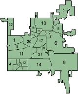
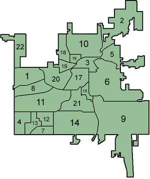
Neighborhoods of Kalamazoo
Encyclopedia
The city of Kalamazoo, Michigan
is divided into multiple neighborhoods. While the number, borders, and naming of neighborhoods can vary by source, the list below gives the most widely agreed upon arrangement, as defined by the City of Kalamazoo. Many of the neighborhoods have a corresponding neighborhood association
.
and the Westwood neighborhood lie to the north, and Oshtemo Township
is to the west. There are approximately four hundred single-family residences in the neighborhood, which are the primary focus of the Arcadia Neighborhood Association. The northern area of the neighborhood contains natural, undeveloped areas.
In 2006, there were 539 reported criminal
incidents in the precinct covering the combined neighborhoods of Arcadia and Knollwood, with the majority of those occurring in Knollwood.
As of the 2000 census, the population of the Arcadia neighborhood was 3529 persons living in 1647 households. The racial
makeup of the neighborhood was 81.30% White, 9.49% Black or African American, 0.43% Native American, 5.02% Asian, 0.00% Native Hawaiian or Pacific Islander, 1.25% from other races, and 2.52% from two or more races. 2.21% of the population were Hispanic or Latino of any race.
on the west and Gull Road on the south. Both Averill Lake and Spring Valley Lake are found within the neighborhood, and the city's Spring Valley Park takes up a large portion of the neighborhood's area. There is currently no neighborhood association for Burke Acres.
In 2006, there were 134 reported criminal
incidents in the Burke Acres neighborhood.
As of the 2000 census, the population of the Burke Acres neighborhood was 3481 persons living in 1414 households. The racial
makeup of the neighborhood was 69.64% White, 23.04% Black or African American, 0.43% Native American, 1.09% Asian, 0.00% Native Hawaiian or Pacific Islander, 1.87% from other races, and 3.94% from two or more races. 2.61% of the population were Hispanic or Latino of any race.
Kalamazoo, is
divided into six districts: Arcadia, Bronson Park, East End, Haymarket, Kalamazoo Mall
, and South Town. Educational and cultural venues include the Kalamazoo Valley Museum
, the central branch of the Kalamazoo Public Library
, and the Kalamazoo Institute of Arts
. The city's nightlife is centered here and includes several nightclubs and microbreweries. The Kalamazoo Transportation Center
is on the north end of the CBD.
As of the 2000 census, 1,420 people in 604 households lived in the Central Business District. The racial
makeup of the district was 75.49% White, 18.45% Black or African American, 0.92% Native American, 1.27% Asian, 0.07% Native Hawaiian or Pacific Islander, 0.35% from other races, and 3.45% from two or more races. 2.18% of the population were Hispanic or Latino of any race.
In 2006, there were 550 reported crime
s in the CBD.
The area's development is fostered by the private, non-profit Downtown Kalamazoo, Inc.
's Business, Technology & Research Park, as well as a small residential population. There is no neighborhood association in the area.
In 2006, there were 7 reported criminal
incidents in the Colony Farm neighborhood.
As of the 2000 census, the population of the Colony Farm neighborhood was 371 persons living in 177 households. The racial
makeup of the neighborhood was 89.76% White, 4.04% Black or African American, 0.27% Native American, 1.35% Asian, 0.00% Native Hawaiian or Pacific Islander, 0.27% from other races, and 4.31% from two or more races. 0.81% of the population were Hispanic or Latino of any race.
. The neighborhood contains two city parks and is situated on the hills which overlook the center of the city from the east. Residents are served by the Eastside Neighborhood Association.
In 2006, there were 247 reported criminal
incidents in the Eastside neighborhood.
As of the 2000 census, the population of the Eastside neighborhood was 2673 persons living in 883 households. The racial
makeup of the neighborhood was 31.31% White, 58.51% Black or African American, 1.80% Native American, 0.41% Asian, 0.22% Native Hawaiian or Pacific Islander, 2.84% from other races, and 4.90% from two or more races. 5.09% of the population were Hispanic or Latino of any race.
and Kalamazoo Kingdom
sports teams play. Residents are served by the Edison Neighborhood Association.
In 2006, there were 1127 reported criminal
incidents in the Edison neighborhood.
As of the 2000 census, the population of the Edison neighborhood was 9415 persons living in 3288 households. The racial
makeup of the neighborhood was 56.14% White, 27.59% Black or African American, 1.39% Native American, 0.72% Asian, 0.10% Native Hawaiian or Pacific Islander, 8.39% from other races, and 5.66% from two or more races. 13.24% of the population were Hispanic or Latino of any race.
incidents in the Hill 'N' Brook neighborhood.
As of the 2000 census, the population of the Hill 'N' Brook neighborhood was 451 persons living in 188 households. The racial
makeup of the neighborhood was 89.58% White, 4.21% Black or African American, 0.00% Native American, 4.43% Asian, 0.00% Native Hawaiian or Pacific Islander, 0.89% from other races, and 0.89% from two or more races. 2.00% of the population were Hispanic or Latino of any race.
In 2006, there were 539 reported criminal
incidents in the precinct covering the combined neighborhoods of Arcadia and Knollwood, with the majority of those occurring in Knollwood.
As of the 2000 census, the population of the Knollwood neighborhood was 5633 persons living in 2101 households. The racial
makeup of the neighborhood was 74.28% White, 14.17% Black or African American, 0.53% Native American, 5.04% Asian, 0.04% Native Hawaiian or Pacific Islander, 2.54% from other races, and 3.41% from two or more races. 4.69% of the population were Hispanic or Latino of any race.
. Milwood is the second largest neighborhood in the city in terms of population, and is the largest in area at 12.6 km². Most of the housing, consisting largely of single-family dwellings, lies in the north and west portions of the neighborhood, with the east remaining largely undeveloped. Residents are served by the Milwood Neighborhood Watch Association.
In 2006, there were 511 reported criminal
incidents in the Milwood neighborhood.
As of the 2000 census, the population of the Milwood neighborhood was 7918 persons living in 3632 households. The racial
makeup of the neighborhood was 87.61% White, 7.60% Black or African American, 0.45% Native American, 0.87% Asian, 0.00% Native Hawaiian or Pacific Islander, 1.23% from other races, and 2.24% from two or more races. 2.75% of the population were Hispanic or Latino of any race.
In 2006, there were 605 reported criminal
incidents in the Northside neighborhood.
As of the 2000 census, the population of the Northside neighborhood was 5669 persons living in 1965 households. The racial
makeup of the neighborhood was 10.83% White, 83.35% Black or African American, 0.42% Native American, 0.19% Asian, 0.05% Native Hawaiian or Pacific Islander, 2.17% from other races, and 2.98% from two or more races. 4.07% of the population were Hispanic or Latino of any race.
The south shore of Woods Lake, along the border with the Oakwood neighborhood, is the former site of a succession of popular amusement parks which lasted from the 1890s to 1920s.
In 2006, there were 144 reported criminal
incidents in the Oakland / Winchell neighborhood.
As of the 2000 census, the population of the Oakland / Winchell neighborhood was 4299 persons living in 1903 households. The racial
makeup of the neighborhood was 87.88% White, 7.70% Black or African American, 0.19% Native American, 2.26% Asian, 0.00% Native Hawaiian or Pacific Islander, 0.44% from other races, and 1.54% from two or more races. 1.21% of the population were Hispanic or Latino of any race.
In 2006, there were 42 reported criminal
incidents in the Oakwood neighborhood.
As of the 2000 census, the population of the Oakwood neighborhood was 1382 persons living in 609 households. The racial
makeup of the neighborhood was 90.59% White, 4.12% Black or African American, 0.58% Native American, 0.72% Asian, 0.00% Native Hawaiian or Pacific Islander, 2.24% from other races, and 1.74% from two or more races. 3.04% of the population were Hispanic or Latino of any race.
incidents in the Parkview Hills neighborhood.
As of the 2000 census, the population of the Parkview Hills neighborhood was 1125 persons living in 693 households. The racial
makeup of the neighborhood was 90.84% White, 3.02% Black or African American, 0.27% Native American, 3.64% Asian, 0.09% Native Hawaiian or Pacific Islander, 0.27% from other races, and 1.87% from two or more races. 1.60% of the population were Hispanic or Latino of any race.
incidents in the South Westnedge neighborhood.
As of the 2000 census, the population of the South Westnedge neighborhood was 5266 persons living in 2429 households. The racial
makeup of the neighborhood was 85.24% White, 8.79% Black or African American, 0.34% Native American, 1.90% Asian, 0.17% Native Hawaiian or Pacific Islander, 0.72% from other races, and 2.83% from two or more races. 2.05% of the population were Hispanic or Latino of any race.
incidents in the precinct covering the combined neighborhoods of Southside and Westnedge Hill, with the majority of those occurring in Westnedge Hill.
As of the 2000 census, the population of the Southside neighborhood was 795 persons living in 305 households. The racial
makeup of the neighborhood was 75.72% White, 15.35% Black or African American, 0.88% Native American, 0.63% Asian, 0.00% Native Hawaiian or Pacific Islander, 2.52% from other races, and 4.91% from two or more races. 5.28% of the population were Hispanic or Latino of any race.
Charles Stuart
began constructing a home here in 1854. Initially a wealthy area of small population density, the neighborhood opened up to the middle class when horse-drawn trolley car service began connecting it to the city center in the 1880s. Many of the Historic Stuart Neighborhood's homes date back to this late 19th-century population boom, and there are a large number of well-preserved residences in styles such as Queen Anne
and Italianate
. The neighborhood is listed on the National Register of Historic Places
.
Residents and property owners are served by the Stuart Area Restoration Association, a 501(c)(3) charitable organization founded in 1973. The Association owns 530 Douglas, Kalamazoo, MI and uses this 1910 American Four Square style house as office, neighborhood center, and plant-sharing garden.
In 2010, there were 88 reported criminal
incidents in the Stuart neighborhood.
As of the 2000 census, the population of the Stuart neighborhood was 1011 persons living in 536 households. The racial
makeup of the neighborhood was 73.69% White, 18.69% Black or African American, 0.40% Native American, 0.89% Asian, 0.30% Native Hawaiian or Pacific Islander, 1.48% from other races, and 4.55% from two or more races. 2.47% of the population were Hispanic or Latino of any race.
residents have been served by the Vine Neighborhood Association. The Vine Neighborhood Association is located at 511 West Vine Street, Kalamazoo, MI.
As of the 2000 census, the population of the Vine neighborhood was 6079 persons living in 2656 households. The racial
makeup of the neighborhood was 78.65% White, 13.23% Black or African American, 0.77% Native American, 1.25% Asian, 0.07% Native Hawaiian or Pacific Islander, 2.24% from other races, and 3.80% from two or more races. 4.39% of the population were Hispanic or Latino of any race.
incidents in the West Douglas / Fairmont neighborhood.
As of the 2000 census, the population of the West Douglas / Fairmont neighborhood was 2550 persons living in 1004 households. The racial
makeup of the neighborhood was 57.88% White, 32.78% Black or African American, 0.51% Native American, 0.82% Asian, 0.00% Native Hawaiian or Pacific Islander, 3.53% from other races, and 4.47% from two or more races. 5.33% of the population were Hispanic or Latino of any race.
incidents in the West Main Hill neighborhood.
As of the 2000 census, the population of the West Main Hill neighborhood was 1661 persons living in 346 households. The racial
makeup of the neighborhood was 90.67% White, 3.01% Black or African American, 0.00% Native American, 3.37% Asian, 0.00% Native Hawaiian or Pacific Islander, 1.32% from other races, and 1.63% from two or more races. 2.11% of the population were Hispanic or Latino of any race.
incidents in the Western Michigan University / Kalamazoo Regional Psychiatric Hospital neighborhood.
As of the 2000 census, the population of the Western Michigan University / Kalamazoo Regional Psychiatric Hospital neighborhood was 7245 persons living in 630 households. The racial
makeup of the neighborhood was 77.16% White, 10.95% Black or African American, 0.19% Native American, 8.83% Asian, 0.17% Native Hawaiian or Pacific Islander, 0.90% from other races, and 1.81% from two or more races. 2.24% of the population were Hispanic or Latino of any race.
incidents in the precinct covering the combined neighborhoods of Southside and Westnedge Hill, with the majority of those occurring in Westnedge Hill.
As of the 2000 census, the population of the Westnedge Hill neighborhood was 3027 persons living in 1388 households. The racial
makeup of the neighborhood was 87.58% White, 7.30% Black or African American, 0.17% Native American, 1.42% Asian, 0.00% Native Hawaiian or Pacific Islander, 0.96% from other races, and 2.58% from two or more races. 2.02% of the population were Hispanic or Latino of any race.
incidents in the Westwood neighborhood.
As of the 2000 census, the population of the Westwood neighborhood was 2145 persons living in 1015 households. The racial
makeup of the neighborhood was 81.17% White, 14.17% Black or African American, 0.23% Native American, 2.24% Asian, 0.00% Native Hawaiian or Pacific Islander, 0.93% from other races, and 1.26% from two or more races. 2.14% of the population were Hispanic or Latino of any race.
Kalamazoo, Michigan
The area on which the modern city stands was once home to Native Americans of the Hopewell culture, who migrated into the area sometime before the first millennium. Evidence of their early residency remains in the form of a small mound in downtown's Bronson Park. The Hopewell civilization began to...
is divided into multiple neighborhoods. While the number, borders, and naming of neighborhoods can vary by source, the list below gives the most widely agreed upon arrangement, as defined by the City of Kalamazoo. Many of the neighborhoods have a corresponding neighborhood association
Neighborhood association
A neighborhood association is a group of residents or property owners who advocate for or organize activities within a neighborhood. An association may have elected leaders and voluntary dues....
.
- Arcadia
- Burke Acres
- Central Business District
- Colony Farm
- Eastside
- Edison
- Hill 'N' Brook
- Knollwood
- Milwood
- Northside
- Oakland / Winchell
- Oakwood
- Parkview Hills
- South Westnedge
- Southside
- Stuart
- Vine
- West Douglas / Fairmont
- West Main Hill
- Western Michigan University / Kalamazoo Regional Psychiatric Hospital
- Westnedge Hill
- Westwood
Arcadia
The Arcadia neighborhood is on the west side of Kalamazoo, bounded on the south by West Michigan Avenue and on the east by Howard Street. Kalamazoo TownshipKalamazoo Township, Michigan
Kalamazoo Charter Township is a charter township of Kalamazoo County in the U.S. state of Michigan. The population was 21,675 at the 2000 census....
and the Westwood neighborhood lie to the north, and Oshtemo Township
Oshtemo Township, Michigan
Oshtemo Charter Township is a charter township of Kalamazoo County in the U.S. state of Michigan. The population was 17,003 at the 2000 census...
is to the west. There are approximately four hundred single-family residences in the neighborhood, which are the primary focus of the Arcadia Neighborhood Association. The northern area of the neighborhood contains natural, undeveloped areas.
In 2006, there were 539 reported criminal
Crime
Crime is the breach of rules or laws for which some governing authority can ultimately prescribe a conviction...
incidents in the precinct covering the combined neighborhoods of Arcadia and Knollwood, with the majority of those occurring in Knollwood.
As of the 2000 census, the population of the Arcadia neighborhood was 3529 persons living in 1647 households. The racial
Race (United States Census)
Race and ethnicity in the United States Census, as defined by the Federal Office of Management and Budget and the United States Census Bureau, are self-identification data items in which residents choose the race or races with which they most closely identify, and indicate whether or not they are...
makeup of the neighborhood was 81.30% White, 9.49% Black or African American, 0.43% Native American, 5.02% Asian, 0.00% Native Hawaiian or Pacific Islander, 1.25% from other races, and 2.52% from two or more races. 2.21% of the population were Hispanic or Latino of any race.
Burke Acres
Burke Acres lies on the northeast side of Kalamazoo, bounded by the Kalamazoo RiverKalamazoo River
The Kalamazoo River is a river in the U.S. state of Michigan. The river is long from the junction of its North and South branches to its mouth at Lake Michigan, with a total length extending to when one includes the South Branch...
on the west and Gull Road on the south. Both Averill Lake and Spring Valley Lake are found within the neighborhood, and the city's Spring Valley Park takes up a large portion of the neighborhood's area. There is currently no neighborhood association for Burke Acres.
In 2006, there were 134 reported criminal
Crime
Crime is the breach of rules or laws for which some governing authority can ultimately prescribe a conviction...
incidents in the Burke Acres neighborhood.
As of the 2000 census, the population of the Burke Acres neighborhood was 3481 persons living in 1414 households. The racial
Race (United States Census)
Race and ethnicity in the United States Census, as defined by the Federal Office of Management and Budget and the United States Census Bureau, are self-identification data items in which residents choose the race or races with which they most closely identify, and indicate whether or not they are...
makeup of the neighborhood was 69.64% White, 23.04% Black or African American, 0.43% Native American, 1.09% Asian, 0.00% Native Hawaiian or Pacific Islander, 1.87% from other races, and 3.94% from two or more races. 2.61% of the population were Hispanic or Latino of any race.
Central Business District
The Central Business District, or downtownDowntown
Downtown is a term primarily used in North America by English speakers to refer to a city's core or central business district ....
Kalamazoo, is
divided into six districts: Arcadia, Bronson Park, East End, Haymarket, Kalamazoo Mall
Kalamazoo Mall
The Kalamazoo Mall, the first outdoor pedestrian shopping mall in the United States, is a section of Burdick Street in downtown Kalamazoo, Michigan....
, and South Town. Educational and cultural venues include the Kalamazoo Valley Museum
Kalamazoo Valley Museum
The Kalamazoo Valley Museum is a "hands-on" museum located in Kalamazoo, Michigan. The museum is largely aimed at families, and focuses on science, technology, and history...
, the central branch of the Kalamazoo Public Library
Kalamazoo Public Library
The Kalamazoo Public Library is an independent district library in Kalamazoo, Michigan, that serves about 120,000 people, has a salaried staff of 90, and spends about $10 million annually. The library consists of the central branch downtown, and four branch libraries.-History:Kalamazoo Public...
, and the Kalamazoo Institute of Arts
Kalamazoo Institute of Arts
The Kalamazoo Institute of Arts is a non-profit visual arts museum and school in downtown Kalamazoo, Michigan, United States. Admission to most exhibitions and programs is free.-History:...
. The city's nightlife is centered here and includes several nightclubs and microbreweries. The Kalamazoo Transportation Center
Kalamazoo Transportation Center
The Kalamazoo Transportation Center is an intermodal complex in downtown Kalamazoo, Michigan. Amtrak and Greyhound provide regular service there...
is on the north end of the CBD.
As of the 2000 census, 1,420 people in 604 households lived in the Central Business District. The racial
Race (United States Census)
Race and ethnicity in the United States Census, as defined by the Federal Office of Management and Budget and the United States Census Bureau, are self-identification data items in which residents choose the race or races with which they most closely identify, and indicate whether or not they are...
makeup of the district was 75.49% White, 18.45% Black or African American, 0.92% Native American, 1.27% Asian, 0.07% Native Hawaiian or Pacific Islander, 0.35% from other races, and 3.45% from two or more races. 2.18% of the population were Hispanic or Latino of any race.
In 2006, there were 550 reported crime
Crime
Crime is the breach of rules or laws for which some governing authority can ultimately prescribe a conviction...
s in the CBD.
The area's development is fostered by the private, non-profit Downtown Kalamazoo, Inc.
Colony Farm
Located in the southwest corner of Kalamazoo, Colony Farm is home to Western Michigan UniversityWestern Michigan University
Western Michigan University is a public university located in Kalamazoo, Michigan, United States. The university was established in 1903 by Dwight B. Waldo, and as of the Fall 2010 semester, its enrollment is 25,045....
's Business, Technology & Research Park, as well as a small residential population. There is no neighborhood association in the area.
In 2006, there were 7 reported criminal
Crime
Crime is the breach of rules or laws for which some governing authority can ultimately prescribe a conviction...
incidents in the Colony Farm neighborhood.
As of the 2000 census, the population of the Colony Farm neighborhood was 371 persons living in 177 households. The racial
Race (United States Census)
Race and ethnicity in the United States Census, as defined by the Federal Office of Management and Budget and the United States Census Bureau, are self-identification data items in which residents choose the race or races with which they most closely identify, and indicate whether or not they are...
makeup of the neighborhood was 89.76% White, 4.04% Black or African American, 0.27% Native American, 1.35% Asian, 0.00% Native Hawaiian or Pacific Islander, 0.27% from other races, and 4.31% from two or more races. 0.81% of the population were Hispanic or Latino of any race.
Eastside
Eastside, along with Burke Acres, is one of the two neighborhoods of Kalamazoo located on the east side of the Kalamazoo RiverKalamazoo River
The Kalamazoo River is a river in the U.S. state of Michigan. The river is long from the junction of its North and South branches to its mouth at Lake Michigan, with a total length extending to when one includes the South Branch...
. The neighborhood contains two city parks and is situated on the hills which overlook the center of the city from the east. Residents are served by the Eastside Neighborhood Association.
In 2006, there were 247 reported criminal
Crime
Crime is the breach of rules or laws for which some governing authority can ultimately prescribe a conviction...
incidents in the Eastside neighborhood.
As of the 2000 census, the population of the Eastside neighborhood was 2673 persons living in 883 households. The racial
Race (United States Census)
Race and ethnicity in the United States Census, as defined by the Federal Office of Management and Budget and the United States Census Bureau, are self-identification data items in which residents choose the race or races with which they most closely identify, and indicate whether or not they are...
makeup of the neighborhood was 31.31% White, 58.51% Black or African American, 1.80% Native American, 0.41% Asian, 0.22% Native Hawaiian or Pacific Islander, 2.84% from other races, and 4.90% from two or more races. 5.09% of the population were Hispanic or Latino of any race.
Edison
The most populous neighborhood in Kalamazoo, Edison is located on the east side of the city. It is home to the bulk of the city's Hispanic population. Recently, local real estate agents have been cooperating to develop a portion of Edison as the center of Kalamazoo's gay and lesbian community. Four of the city's parks are located in the Edison neighborhood, including the Mayor's Riverfront Park, where the Kalamazoo KingsKalamazoo Kings
The Kalamazoo Kings are a professional baseball team based in Kalamazoo, Michigan, in the United States. The Kings are a member of the Eastern Division of the Frontier League, which is not affiliated with Major League Baseball...
and Kalamazoo Kingdom
Kalamazoo Kingdom
Kalamazoo Kingdom were an American soccer team, founded in 1996. The team was a member of the United Soccer Leagues Premier Development League , the fourth tier of the American Soccer Pyramid, until 2006, when the team left the league and the franchise was terminated.The Kingdom folded their...
sports teams play. Residents are served by the Edison Neighborhood Association.
In 2006, there were 1127 reported criminal
Crime
Crime is the breach of rules or laws for which some governing authority can ultimately prescribe a conviction...
incidents in the Edison neighborhood.
As of the 2000 census, the population of the Edison neighborhood was 9415 persons living in 3288 households. The racial
Race (United States Census)
Race and ethnicity in the United States Census, as defined by the Federal Office of Management and Budget and the United States Census Bureau, are self-identification data items in which residents choose the race or races with which they most closely identify, and indicate whether or not they are...
makeup of the neighborhood was 56.14% White, 27.59% Black or African American, 1.39% Native American, 0.72% Asian, 0.10% Native Hawaiian or Pacific Islander, 8.39% from other races, and 5.66% from two or more races. 13.24% of the population were Hispanic or Latino of any race.
Hill 'N' Brook
In 2006, there were no reported criminalCrime
Crime is the breach of rules or laws for which some governing authority can ultimately prescribe a conviction...
incidents in the Hill 'N' Brook neighborhood.
As of the 2000 census, the population of the Hill 'N' Brook neighborhood was 451 persons living in 188 households. The racial
Race (United States Census)
Race and ethnicity in the United States Census, as defined by the Federal Office of Management and Budget and the United States Census Bureau, are self-identification data items in which residents choose the race or races with which they most closely identify, and indicate whether or not they are...
makeup of the neighborhood was 89.58% White, 4.21% Black or African American, 0.00% Native American, 4.43% Asian, 0.00% Native Hawaiian or Pacific Islander, 0.89% from other races, and 0.89% from two or more races. 2.00% of the population were Hispanic or Latino of any race.
Knollwood
The Knollwood neighborhood lies on the west side of the city, adjacent to Western Michigan University. As such, there is a good deal of student housing in Knollwood, especially on the east side closer to campus. Unlike other student housing areas, such as the Stuart and West Main Hill Neighborhoods, which feature individual houses and portions of houses for rent, housing in Knollwood is primarily in apartment complexes. Knollwood is also home to a number of Western Michigan University's sorority and fraternity houses. There is currently no neighborhood association in the area.In 2006, there were 539 reported criminal
Crime
Crime is the breach of rules or laws for which some governing authority can ultimately prescribe a conviction...
incidents in the precinct covering the combined neighborhoods of Arcadia and Knollwood, with the majority of those occurring in Knollwood.
As of the 2000 census, the population of the Knollwood neighborhood was 5633 persons living in 2101 households. The racial
Race (United States Census)
Race and ethnicity in the United States Census, as defined by the Federal Office of Management and Budget and the United States Census Bureau, are self-identification data items in which residents choose the race or races with which they most closely identify, and indicate whether or not they are...
makeup of the neighborhood was 74.28% White, 14.17% Black or African American, 0.53% Native American, 5.04% Asian, 0.04% Native Hawaiian or Pacific Islander, 2.54% from other races, and 3.41% from two or more races. 4.69% of the population were Hispanic or Latino of any race.
Milwood
The Milwood neighborhood occupies the southeast corner of the city, and includes a large projection to the south encompassing the Kalamazoo-Battle Creek International AirportKalamazoo-Battle Creek International Airport
Kalamazoo/Battle Creek International Airport is a county-owned public-use airport located three nautical miles southeast of the central business district of Kalamazoo, a city in Kalamazoo County, Michigan, United States. The airport is also near the city of Battle CreekThe airport has an air...
. Milwood is the second largest neighborhood in the city in terms of population, and is the largest in area at 12.6 km². Most of the housing, consisting largely of single-family dwellings, lies in the north and west portions of the neighborhood, with the east remaining largely undeveloped. Residents are served by the Milwood Neighborhood Watch Association.
In 2006, there were 511 reported criminal
Crime
Crime is the breach of rules or laws for which some governing authority can ultimately prescribe a conviction...
incidents in the Milwood neighborhood.
As of the 2000 census, the population of the Milwood neighborhood was 7918 persons living in 3632 households. The racial
Race (United States Census)
Race and ethnicity in the United States Census, as defined by the Federal Office of Management and Budget and the United States Census Bureau, are self-identification data items in which residents choose the race or races with which they most closely identify, and indicate whether or not they are...
makeup of the neighborhood was 87.61% White, 7.60% Black or African American, 0.45% Native American, 0.87% Asian, 0.00% Native Hawaiian or Pacific Islander, 1.23% from other races, and 2.24% from two or more races. 2.75% of the population were Hispanic or Latino of any race.
Northside
Northside is home to over one quarter of the city's African American population (as of the 2000 census), and along with the Eastside neighborhood is one of the two communities in Kalamazoo wherein African Americans form a majority. The Northside is home to a number of the city's parks, as well as a large concentration of social services providers. Neighborhood residents are served by the Northside Association for Community Development.In 2006, there were 605 reported criminal
Crime
Crime is the breach of rules or laws for which some governing authority can ultimately prescribe a conviction...
incidents in the Northside neighborhood.
As of the 2000 census, the population of the Northside neighborhood was 5669 persons living in 1965 households. The racial
Race (United States Census)
Race and ethnicity in the United States Census, as defined by the Federal Office of Management and Budget and the United States Census Bureau, are self-identification data items in which residents choose the race or races with which they most closely identify, and indicate whether or not they are...
makeup of the neighborhood was 10.83% White, 83.35% Black or African American, 0.42% Native American, 0.19% Asian, 0.05% Native Hawaiian or Pacific Islander, 2.17% from other races, and 2.98% from two or more races. 4.07% of the population were Hispanic or Latino of any race.
Oakland / Winchell
The Oakland / Winchell neighborhood is located on the west side of the city and named for the two main streets near which the bulk of its residents live. The western third of the neighborhood is largely undeveloped green space, centered around Asylum Lake. In the southeast corner are two city parks, both on the edge of Woods Lake. Residents are served by the Oakland Drive / Winchell Avenue Neighborhood Association.The south shore of Woods Lake, along the border with the Oakwood neighborhood, is the former site of a succession of popular amusement parks which lasted from the 1890s to 1920s.
In 2006, there were 144 reported criminal
Crime
Crime is the breach of rules or laws for which some governing authority can ultimately prescribe a conviction...
incidents in the Oakland / Winchell neighborhood.
As of the 2000 census, the population of the Oakland / Winchell neighborhood was 4299 persons living in 1903 households. The racial
Race (United States Census)
Race and ethnicity in the United States Census, as defined by the Federal Office of Management and Budget and the United States Census Bureau, are self-identification data items in which residents choose the race or races with which they most closely identify, and indicate whether or not they are...
makeup of the neighborhood was 87.88% White, 7.70% Black or African American, 0.19% Native American, 2.26% Asian, 0.00% Native Hawaiian or Pacific Islander, 0.44% from other races, and 1.54% from two or more races. 1.21% of the population were Hispanic or Latino of any race.
Oakwood
The Oakwood Neighborhood Association is one of the oldest in the city, having incorporated in 1947, although the region itself was not annexed to the city until 1957.In 2006, there were 42 reported criminal
Crime
Crime is the breach of rules or laws for which some governing authority can ultimately prescribe a conviction...
incidents in the Oakwood neighborhood.
As of the 2000 census, the population of the Oakwood neighborhood was 1382 persons living in 609 households. The racial
Race (United States Census)
Race and ethnicity in the United States Census, as defined by the Federal Office of Management and Budget and the United States Census Bureau, are self-identification data items in which residents choose the race or races with which they most closely identify, and indicate whether or not they are...
makeup of the neighborhood was 90.59% White, 4.12% Black or African American, 0.58% Native American, 0.72% Asian, 0.00% Native Hawaiian or Pacific Islander, 2.24% from other races, and 1.74% from two or more races. 3.04% of the population were Hispanic or Latino of any race.
Parkview Hills
In 2006, there were 16 reported criminalCrime
Crime is the breach of rules or laws for which some governing authority can ultimately prescribe a conviction...
incidents in the Parkview Hills neighborhood.
As of the 2000 census, the population of the Parkview Hills neighborhood was 1125 persons living in 693 households. The racial
Race (United States Census)
Race and ethnicity in the United States Census, as defined by the Federal Office of Management and Budget and the United States Census Bureau, are self-identification data items in which residents choose the race or races with which they most closely identify, and indicate whether or not they are...
makeup of the neighborhood was 90.84% White, 3.02% Black or African American, 0.27% Native American, 3.64% Asian, 0.09% Native Hawaiian or Pacific Islander, 0.27% from other races, and 1.87% from two or more races. 1.60% of the population were Hispanic or Latino of any race.
South Westnedge
In 2006, there were 206 reported criminalCrime
Crime is the breach of rules or laws for which some governing authority can ultimately prescribe a conviction...
incidents in the South Westnedge neighborhood.
As of the 2000 census, the population of the South Westnedge neighborhood was 5266 persons living in 2429 households. The racial
Race (United States Census)
Race and ethnicity in the United States Census, as defined by the Federal Office of Management and Budget and the United States Census Bureau, are self-identification data items in which residents choose the race or races with which they most closely identify, and indicate whether or not they are...
makeup of the neighborhood was 85.24% White, 8.79% Black or African American, 0.34% Native American, 1.90% Asian, 0.17% Native Hawaiian or Pacific Islander, 0.72% from other races, and 2.83% from two or more races. 2.05% of the population were Hispanic or Latino of any race.
Southside
In 2006, there were 287 reported criminalCrime
Crime is the breach of rules or laws for which some governing authority can ultimately prescribe a conviction...
incidents in the precinct covering the combined neighborhoods of Southside and Westnedge Hill, with the majority of those occurring in Westnedge Hill.
As of the 2000 census, the population of the Southside neighborhood was 795 persons living in 305 households. The racial
Race (United States Census)
Race and ethnicity in the United States Census, as defined by the Federal Office of Management and Budget and the United States Census Bureau, are self-identification data items in which residents choose the race or races with which they most closely identify, and indicate whether or not they are...
makeup of the neighborhood was 75.72% White, 15.35% Black or African American, 0.88% Native American, 0.63% Asian, 0.00% Native Hawaiian or Pacific Islander, 2.52% from other races, and 4.91% from two or more races. 5.28% of the population were Hispanic or Latino of any race.
Stuart
Located just northwest of the central business district, the Stuart area began as an early suburb of Kalamazoo when US SenatorUnited States Senate
The United States Senate is the upper house of the bicameral legislature of the United States, and together with the United States House of Representatives comprises the United States Congress. The composition and powers of the Senate are established in Article One of the U.S. Constitution. Each...
Charles Stuart
Charles E. Stuart
Charles Edward Stuart was a U.S. Representative and U.S. Senator from the state of Michigan.-Biography:Stuart was born in New York, either near Waterloo, New York, or in Columbia County. He studied law, was admitted to the bar in 1832, and commenced practice in Waterloo...
began constructing a home here in 1854. Initially a wealthy area of small population density, the neighborhood opened up to the middle class when horse-drawn trolley car service began connecting it to the city center in the 1880s. Many of the Historic Stuart Neighborhood's homes date back to this late 19th-century population boom, and there are a large number of well-preserved residences in styles such as Queen Anne
Queen Anne Style architecture
The Queen Anne Style in Britain means either the English Baroque architectural style roughly of the reign of Queen Anne , or a revived form that was popular in the last quarter of the 19th century and the early decades of the 20th century...
and Italianate
Italianate architecture
The Italianate style of architecture was a distinct 19th-century phase in the history of Classical architecture. In the Italianate style, the models and architectural vocabulary of 16th-century Italian Renaissance architecture, which had served as inspiration for both Palladianism and...
. The neighborhood is listed on the National Register of Historic Places
National Register of Historic Places
The National Register of Historic Places is the United States government's official list of districts, sites, buildings, structures, and objects deemed worthy of preservation...
.
Residents and property owners are served by the Stuart Area Restoration Association, a 501(c)(3) charitable organization founded in 1973. The Association owns 530 Douglas, Kalamazoo, MI and uses this 1910 American Four Square style house as office, neighborhood center, and plant-sharing garden.
In 2010, there were 88 reported criminal
Crime
Crime is the breach of rules or laws for which some governing authority can ultimately prescribe a conviction...
incidents in the Stuart neighborhood.
As of the 2000 census, the population of the Stuart neighborhood was 1011 persons living in 536 households. The racial
Race (United States Census)
Race and ethnicity in the United States Census, as defined by the Federal Office of Management and Budget and the United States Census Bureau, are self-identification data items in which residents choose the race or races with which they most closely identify, and indicate whether or not they are...
makeup of the neighborhood was 73.69% White, 18.69% Black or African American, 0.40% Native American, 0.89% Asian, 0.30% Native Hawaiian or Pacific Islander, 1.48% from other races, and 4.55% from two or more races. 2.47% of the population were Hispanic or Latino of any race.
Vine
Since 1980, Vine Neighborhood, KalamazooVine Neighborhood, Kalamazoo
The Vine Neighborhood is a neighborhood in Kalamazoo, Michigan. Its boundaries are West Lovell Street to the north, Oakland Drive to the west, Crosstown Parkway to the south, and South Burdick Street to the east.-History:...
residents have been served by the Vine Neighborhood Association. The Vine Neighborhood Association is located at 511 West Vine Street, Kalamazoo, MI.
As of the 2000 census, the population of the Vine neighborhood was 6079 persons living in 2656 households. The racial
Race (United States Census)
Race and ethnicity in the United States Census, as defined by the Federal Office of Management and Budget and the United States Census Bureau, are self-identification data items in which residents choose the race or races with which they most closely identify, and indicate whether or not they are...
makeup of the neighborhood was 78.65% White, 13.23% Black or African American, 0.77% Native American, 1.25% Asian, 0.07% Native Hawaiian or Pacific Islander, 2.24% from other races, and 3.80% from two or more races. 4.39% of the population were Hispanic or Latino of any race.
West Douglas / Fairmont
In 2006, there were 131 reported criminalCrime
Crime is the breach of rules or laws for which some governing authority can ultimately prescribe a conviction...
incidents in the West Douglas / Fairmont neighborhood.
As of the 2000 census, the population of the West Douglas / Fairmont neighborhood was 2550 persons living in 1004 households. The racial
Race (United States Census)
Race and ethnicity in the United States Census, as defined by the Federal Office of Management and Budget and the United States Census Bureau, are self-identification data items in which residents choose the race or races with which they most closely identify, and indicate whether or not they are...
makeup of the neighborhood was 57.88% White, 32.78% Black or African American, 0.51% Native American, 0.82% Asian, 0.00% Native Hawaiian or Pacific Islander, 3.53% from other races, and 4.47% from two or more races. 5.33% of the population were Hispanic or Latino of any race.
West Main Hill
In 2006, there were 101 reported criminalCrime
Crime is the breach of rules or laws for which some governing authority can ultimately prescribe a conviction...
incidents in the West Main Hill neighborhood.
As of the 2000 census, the population of the West Main Hill neighborhood was 1661 persons living in 346 households. The racial
Race (United States Census)
Race and ethnicity in the United States Census, as defined by the Federal Office of Management and Budget and the United States Census Bureau, are self-identification data items in which residents choose the race or races with which they most closely identify, and indicate whether or not they are...
makeup of the neighborhood was 90.67% White, 3.01% Black or African American, 0.00% Native American, 3.37% Asian, 0.00% Native Hawaiian or Pacific Islander, 1.32% from other races, and 1.63% from two or more races. 2.11% of the population were Hispanic or Latino of any race.
Western Michigan University / KRPH
In 2006, there were 37 reported criminalCrime
Crime is the breach of rules or laws for which some governing authority can ultimately prescribe a conviction...
incidents in the Western Michigan University / Kalamazoo Regional Psychiatric Hospital neighborhood.
As of the 2000 census, the population of the Western Michigan University / Kalamazoo Regional Psychiatric Hospital neighborhood was 7245 persons living in 630 households. The racial
Race (United States Census)
Race and ethnicity in the United States Census, as defined by the Federal Office of Management and Budget and the United States Census Bureau, are self-identification data items in which residents choose the race or races with which they most closely identify, and indicate whether or not they are...
makeup of the neighborhood was 77.16% White, 10.95% Black or African American, 0.19% Native American, 8.83% Asian, 0.17% Native Hawaiian or Pacific Islander, 0.90% from other races, and 1.81% from two or more races. 2.24% of the population were Hispanic or Latino of any race.
Westnedge Hill
In 2006, there were 287 reported criminalCrime
Crime is the breach of rules or laws for which some governing authority can ultimately prescribe a conviction...
incidents in the precinct covering the combined neighborhoods of Southside and Westnedge Hill, with the majority of those occurring in Westnedge Hill.
As of the 2000 census, the population of the Westnedge Hill neighborhood was 3027 persons living in 1388 households. The racial
Race (United States Census)
Race and ethnicity in the United States Census, as defined by the Federal Office of Management and Budget and the United States Census Bureau, are self-identification data items in which residents choose the race or races with which they most closely identify, and indicate whether or not they are...
makeup of the neighborhood was 87.58% White, 7.30% Black or African American, 0.17% Native American, 1.42% Asian, 0.00% Native Hawaiian or Pacific Islander, 0.96% from other races, and 2.58% from two or more races. 2.02% of the population were Hispanic or Latino of any race.
Westwood
In 2006, there were 71 reported criminalCrime
Crime is the breach of rules or laws for which some governing authority can ultimately prescribe a conviction...
incidents in the Westwood neighborhood.
As of the 2000 census, the population of the Westwood neighborhood was 2145 persons living in 1015 households. The racial
Race (United States Census)
Race and ethnicity in the United States Census, as defined by the Federal Office of Management and Budget and the United States Census Bureau, are self-identification data items in which residents choose the race or races with which they most closely identify, and indicate whether or not they are...
makeup of the neighborhood was 81.17% White, 14.17% Black or African American, 0.23% Native American, 2.24% Asian, 0.00% Native Hawaiian or Pacific Islander, 0.93% from other races, and 1.26% from two or more races. 2.14% of the population were Hispanic or Latino of any race.