

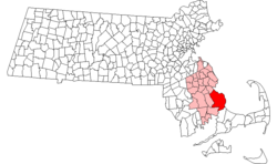
Neighborhoods in Plymouth, Massachusetts
Encyclopedia
Massachusetts
The Commonwealth of Massachusetts is a state in the New England region of the northeastern United States of America. It is bordered by Rhode Island and Connecticut to the south, New York to the west, and Vermont and New Hampshire to the north; at its east lies the Atlantic Ocean. As of the 2010...
by area. In addition, with a population of 51,701 at the 2000 census and an estimated population of 57,901 in 2007, Plymouth is the second-largest town in the state by population (after Framingham
Framingham, Massachusetts
Framingham is a New England town in Middlesex County, Massachusetts, United States. The population was 68,318 as of the United States 2010 Census. -History:...
. As such, Plymouth is home to many distinct neighborhoods and geographical locations.
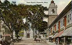
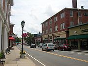
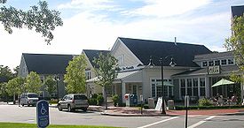
The most prominent of Plymouth's neighborhoods is Plymouth Center, also referred to as Downtown Plymouth. It is home to Plymouth's town hall and harbor
Plymouth Harbor
Plymouth Harbor is the name of a harbor located in Plymouth, Massachusetts, a town in the South Shore region of the state. It is part of the larger Plymouth Bay. Historically, Plymouth Harbor was the site of anchorage of the Mayflower where the Pilgrims offloaded to establish a permanent...
. The geographical regions of North Plymouth
North Plymouth, Massachusetts
North Plymouth is a census-designated place in the town of Plymouth in Plymouth County, Massachusetts, United States. The population was 3,593 at the 2000 census. it is best known as the location of Cordage Park, a small village where the Plymouth Cordage Company was once headquartered...
, South Plymouth
South Plymouth, Massachusetts
South Plymouth is the portion of Plymouth, Massachusetts, United States that covers much of the southern section of the town beginning at the Pine Hills, a large, mostly undeveloped forested area south of Plymouth Beach, Chiltonville and South Pond...
, and West Plymouth
West Plymouth, Massachusetts
West Plymouth is a village in Plymouth, Plymouth County, Massachusetts, United States. It is located beyond the new Colony Place retail development and the Plymouth Industrial Park off U.S. Route 44 and north of Myles Standish State Forest. It stretches west to the Carver town line and north to the...
are named based upon their relationship to Plymouth Center.
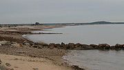
Plymouth has one of the longest coastlines of any town in Massachusetts, and makes up the entire western shore of Cape Cod Bay
Cape Cod Bay
Cape Cod Bay is a large bay of the Atlantic Ocean adjacent to the U.S. state of Massachusetts. Measuring below a line drawn from Brant Rock in Marshfield to Race Point in Provincetown, Massachusetts, it is enclosed by Cape Cod to the south and east, and Plymouth County, Massachusetts, to the west....
. The town is therefore home to a wide array of beach communities.
List of neighborhoods
- Plymouth Center
- Harbor District
- North PlymouthNorth Plymouth, MassachusettsNorth Plymouth is a census-designated place in the town of Plymouth in Plymouth County, Massachusetts, United States. The population was 3,593 at the 2000 census. it is best known as the location of Cordage Park, a small village where the Plymouth Cordage Company was once headquartered...
- Cordage Park
- Saquish Neck (accessible only through Duxbury)
- Gurnet PointGurnet Point, MassachusettsGurnet Point, also known as The Gurnet, is located at the end of the peninsula at the entrance to Plymouth Bay in Plymouth, Massachusetts, and is a headland and the small private settlement located on it. The Pilgrims who settled Plymouth in 1620 named it Gurnett’s Nose for its resemblance to...
- Saquish Head
- Gurnet Point
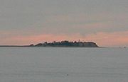
- Clark's IslandClark's IslandClark's Island is the name of a small island located in Plymouth Bay in the U.S. state of Massachusetts. It was named for the first mate of the Mayflower, the ship that brought the Pilgrims to New England. The first mate was Richard Clarke, though the island should actually be spelled Clarke's...
- West PlymouthWest Plymouth, MassachusettsWest Plymouth is a village in Plymouth, Plymouth County, Massachusetts, United States. It is located beyond the new Colony Place retail development and the Plymouth Industrial Park off U.S. Route 44 and north of Myles Standish State Forest. It stretches west to the Carver town line and north to the...
- Micajah HeightsMicajah Heights, MassachusettsMicajah Heights is a neighborhood in Plymouth, Massachusetts, United States, in the West Plymouth section of the town, southwest of Billington Sea. The neighborhood surrounds Micajah Pond.-See also:* Neighborhoods in Plymouth, Massachusetts...
- Billington SeaBillington SeaBillington Sea is a warm water pond located in Plymouth, Massachusetts. Morton Park lies on the pond's northern shore. The pond is fed by groundwater and cranberry bog outlets. The average depth is seven feet and the maximum depth is . The pond provides the headwaters to Town Brook...
- Darby
- East Carver (a portion of this section of CarverCarver, MassachusettsCarver is a town in Plymouth County, Massachusetts, United States. The population was 11,163 at the 2000 census, with an estimated 2008 population of 11,574. It is named for John Carver, the first governor of the Plymouth Colony.- Demographics :...
extends over the town line into Plymouth)
- Micajah Heights
- South PondSouth Pond, MassachusettsSouth Pond is a village in Plymouth, Massachusetts, United States. It is located east of Great South Pond, a reservoir that serves as one of Plymouth's municipal water sources. The village is located north of Myles Standish State Forest, northwest of Long Pond, southwest of Chiltonville and west of...
- Wellingsley (Jabez Corner)Wellingsley, MassachusettsWellingsley, also known as Wellingsly, Jabez Corner, and Hobs Hole, is a neighborhood in Plymouth, Massachusetts, United States. It is notable for being the oldest separate neighborhood in the town. Wellingsley is located one mile south of Plymouth Center and north of Chiltonville...
- ChiltonvilleChiltonville, MassachusettsChiltonville is a small village in Plymouth, Massachusetts, United States. It is located south of Wellingsley, northeast of South Pond, and consists of the Eel River valley and the land that stretches south of the river to the Pine Hills. Plimoth Plantation is in the northeastern part of the village...
- Plymouth BeachPlymouth Beach, MassachusettsPlymouth Beach is a small village located in Plymouth, Massachusetts, United States. It is located directly south of Plymouth Center, and is adjacent to Plimoth Plantation...
- South PlymouthSouth Plymouth, MassachusettsSouth Plymouth is the portion of Plymouth, Massachusetts, United States that covers much of the southern section of the town beginning at the Pine Hills, a large, mostly undeveloped forested area south of Plymouth Beach, Chiltonville and South Pond...
- Rocky PointRocky Point (Massachusetts)Rocky Point is a peninsula in Plymouth, Massachusetts. The peninsula runs along Warren Cove and Plymouth Bay. The tip of the peninsula marks the convergence of Plymouth Bay and the larger Cape Cod Bay...
- The PinehillsThe PinehillsThe Pinehills is a census designated place located in the Pine Hills region of Plymouth, Massachusetts. As of 2008, the project is the largest new residential and commercial development in New England...
- ManometManomet, MassachusettsManomet is a seaside village of Plymouth, Massachusetts, United States. It is named for the Manomet Native American sub-group of the Wampanoag whose settlement was located atop the dominant hill in the region when European settlers arrived in Plymouth in 1620. Manomet has a Post Office in the...
- Priscilla BeachPriscilla Beach, MassachusettsPriscilla Beach is a village of Plymouth, Massachusetts, United States. It consists of a private beach on Cape Cod Bay in the Manomet section of Plymouth, located between Pilgrim Station and White Horse Beach. The Priscilla Beach Association was formed on July 17, 1937, to promote and foster the...
- White Horse BeachWhite Horse Beach, MassachusettsWhite Horse Beach is a village of Plymouth, Massachusetts, United States. It consists of 560 feet of public beach in the White Horse Beach, Massachusetts section of Plymouth and is located on Cape Cod Bay, south of Priscilla Beach...
- Manomet Heights
- Manomet Bluffs
- Fishermans Landing
- Churchill Landing
- Colony Beach
- Pilgrim Beach
- Cedar Bushes
- Shallow PondShallow Pond (Plymouth, Massachusetts)Shallow Pond is an pond in the Manomet section of Plymouth, Massachusetts. The pond is located south of Fresh Pond, north of Briggs Reservoir, southwest of Cedar Bushes and west of Manomet Beach...
Estates - Manomet Beach
- Priscilla Beach
- VallervilleVallerville, MassachusettsVallerville, also called Vallersville, is a village in Plymouth, Massachusetts, United States, the smallest village in the town. It is located south of the village of Manomet and north of the village of Ellisville. The neighborhoods of Ocean Aire Beach, Surfside Beach and Bayside Beach are located...
- Ocean Aire Beach
- Surfside Beach
- Bayside Beach
- EllisvilleEllisville, MassachusettsEllisville is a village in southeastern Plymouth, Massachusetts, United States. It is located on Cape Cod Bay, and is situated south of Vallerville and north of Cedarville. The neighborhoods within Ellisville include Harlow’s Landing and Eastland Heights...
- Harlow’s Landing
- Eastland Heights
- CedarvilleCedarville, MassachusettsCedarville is the southeasternmost village in Plymouth, Massachusetts, United States.Cedarville is bounded to the north by Ellisville Road and Hedges Pond, to the south by the Town of Bourne, to the west by Little Herring Pond and Great Herring Pond, and to the east by Cape Cod Bay.Residents enjoy...
- Nameloc Heights
- Pondville
- Halfway Pond
- Long Pond
- West Wind ShoresWest Wind Shores, MassachusettsWest Wind Shores is a small village in Plymouth, Massachusetts, United States. It is located south of Long Pond and north of Buzzards Bay, Whites Pond, Little Sandy Pond, Big Sandy Pond, and Ezekiel Pond. The village is built around several small ponds....
- White Island ShoresWhite Island Shores, MassachusettsWhite Island Shores is a census-designated place in the town of Plymouth in Plymouth County, Massachusetts, United States, along the shores of White Island Pond. The population was 2,133 at the 2000 census.-Geography:...
- Rocky Point