
Nechako Reservoir
Encyclopedia
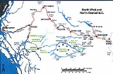
The Nechako Reservoir, sometimes called the Ootsa Lake Reservoir, is a hydroelectric reservoir in British Columbia, Canada that was formed by a diversion of the Nechako River
through the Kitimat Ranges
of the Coast Mountains
to sea level at Kemano
to provide power for the aluminum smelter at Kitimat
. It was one of the biggest reservoirs built in Canada to date, until the completion of the Columbia Treaty Dams and the W.A.C. Bennett Dam that created Lake Williston.
The creation of the reservoir flooded the series of lakes which typified the upper Nechako basin and in the process rendered the Quanchus Range
, which lies between the north and south arms of the reservoir, a virtual island. The names of lakes amalgamated into the reservoir are perpetuated as names for the various stretches of water. The north arm includes Ootsa Lake, Whitesail Lake, and Whitesail Reach, the south arm Eutsuk Lake, Natalkuz Lake, Chedakuz Arm, Knewstubb Lake
, Tetachuck Lake and others. Because Ootsa Lake is the largest of the original lakes its name is sometimes used for the whole reservoir, though the official name remains Nechako Reservoir.
Tweedsmuir North Provincial Park and Protected Area
and Entiako Provincial Park both border the reservoir.
Nechako River
The Nechako River arises on the Nechako Plateau east of the Kitimat Ranges of the Coast Mountains of British Columbia and flows north toward Fort Fraser, then east to Prince George where it enters the Fraser River...
through the Kitimat Ranges
Kitimat Ranges
The Kitimat Ranges are one of the three main subdivisions of the Coast Mountains in British Columbia, Canada, the other being the Pacific Ranges to the south and the Boundary Ranges to the north...
of the Coast Mountains
Coast Mountains
The Coast Mountains are a major mountain range, in the Pacific Coast Ranges, of western North America, extending from southwestern Yukon through the Alaska Panhandle and virtually all of the Coast of British Columbia. They are so-named because of their proximity to the sea coast, and are often...
to sea level at Kemano
Kemano, British Columbia
Kemano is a settlement situated 75 km southeast of Kitimat in the province of British Columbia in Canada. It was built to service a hydroelectric power station, built to provide energy for Alcan to smelt aluminium from its ore. The powerhouse is built 427 m inside the base of Mt Dubose...
to provide power for the aluminum smelter at Kitimat
Kitimat, British Columbia
Kitimat is a coastal city in northwestern British Columbia, in the Regional District of Kitimat-Stikine. The Kitimat Valley, which includes the adjacent community of Terrace, is the most populous urban district in Northwest British Columbia...
. It was one of the biggest reservoirs built in Canada to date, until the completion of the Columbia Treaty Dams and the W.A.C. Bennett Dam that created Lake Williston.
The creation of the reservoir flooded the series of lakes which typified the upper Nechako basin and in the process rendered the Quanchus Range
Quanchus Range
The Quanchus Range is a subrange of the Nechako Plateau in the Interior of British Columbia, Canada, located on the north end of Tweedsmuir North Provincial Park and Protected Area. It is almost completely an island after the creation of the Nechako Reservoir. Its two main summits are Michel Peak ...
, which lies between the north and south arms of the reservoir, a virtual island. The names of lakes amalgamated into the reservoir are perpetuated as names for the various stretches of water. The north arm includes Ootsa Lake, Whitesail Lake, and Whitesail Reach, the south arm Eutsuk Lake, Natalkuz Lake, Chedakuz Arm, Knewstubb Lake
Knewstubb Lake
Knewstubb Lake is an arm or stretch of the Ootsa Lake Reservoir in the Nechako Country of the western Central Interior of British Columbia, Canada. It forms part of the south arm of the reservoir, which includes adjoining stretches such as Eutsuk Lake and Natalkuz Lake, which are "upstream" to the...
, Tetachuck Lake and others. Because Ootsa Lake is the largest of the original lakes its name is sometimes used for the whole reservoir, though the official name remains Nechako Reservoir.
Tweedsmuir North Provincial Park and Protected Area
Tweedsmuir North Provincial Park and Protected Area
Tweedsmuir North Provincial Park and Protected Area is a provincial park in British Columbia, Canada. Formerly part of Tweedsmuir Provincial Park, one of the earliest large parks established in the provincial parks system, it was redesignated a park and protected area as the latter classification...
and Entiako Provincial Park both border the reservoir.
External Links
- "Engineers Invade Another Wilderness - Huge Canadian Power Project Marks 20th Century Frontier Boom" , by Richard Neuberger detailed 1951 Popular Science article on the Kemano Hydro Project