

National Register of Historic Places listings in Williamson County, Tennessee
Encyclopedia

This is intended to be a complete list of the properties and districts on the National Register of Historic Places
National Register of Historic Places
The National Register of Historic Places is the United States government's official list of districts, sites, buildings, structures, and objects deemed worthy of preservation...
in Williamson County
Williamson County, Tennessee
Williamson County is a county in the U.S. state of Tennessee. As of 2010 US Census, the population was 183,182. The County's seat is Franklin, and it is part of the Nashville-Davidson–Murfreesboro–Franklin Metropolitan Statistical Area. The county is named after Hugh Williamson, a...
, Tennessee
Tennessee
Tennessee is a U.S. state located in the Southeastern United States. It has a population of 6,346,105, making it the nation's 17th-largest state by population, and covers , making it the 36th-largest by total land area...
, United States
United States
The United States of America is a federal constitutional republic comprising fifty states and a federal district...
. Latitude and longitude coordinates are provided for many National Register properties and districts; these locations may be seen together in a Google map.
There are 134 properties and districts listed on the National Register in the county, including 2 National Historic Landmark
National Historic Landmark
A National Historic Landmark is a building, site, structure, object, or district, that is officially recognized by the United States government for its historical significance...
s. Another 5 properties were once listed but have been removed.
Current listings
|--! | 1
| Adams Street Historic District
Adams Street Historic District
The Adams Street Historic District in Franklin, Tennessee consists of properties at 1112-1400 Adams, 1251-1327 Adams St., and 304-308 Stewart St. It is a 14 acre historic district that was listed on the National Register of Historic Places in 2000....
|
|
| 1112-1400 Adams, 1251-1327 Adams St., and 304-308 Stewart St.
35°45′48"N 86°41′25"W
| Franklin
Franklin, Tennessee
Franklin is a city within and the county seat of Williamson County, Tennessee, United States. The population was 62,487 as of the 2010 census Franklin is located approximately south of downtown Nashville.-History:...
| historic district
Historic district (United States)
In the United States, a historic district is a group of buildings, properties, or sites that have been designated by one of several entities on different levels as historically or architecturally significant. Buildings, structures, objects and sites within a historic district are normally divided...
with 37 buildings including Bungalow/Craftsman architecture and Victorian vernacular architecture
|--
! | 2
| William Allison House
William Allison House (College Grove, Tennessee)
The William Allison House near College Grove, Tennessee is a historic Federal style house with a central passage plan. It was listed on the National Register of Historic Places in 1988....
|
|
| Alternate U.S. Route 31
U.S. Route 31
U.S. Route 31 is a long north–south highway connecting northern Michigan to southern Alabama, with its northern terminus at Interstate 75 near Mackinaw City, Michigan, and southern terminus at the combined U.S. Route 90 & U.S. Route 98 at Spanish Fort, Alabama...
, 2 miles south of College Grove
35°45′48"N 86°41′25"W
| College Grove
College Grove, Tennessee
College Grove is an unincorporated town near Franklin and Murfreesboro in Williamson County, Tennessee, United States. College Grove is predominantly rural....
| Historic Federal
Federal architecture
Federal-style architecture is the name for the classicizing architecture built in the United States between c. 1780 and 1830, and particularly from 1785 to 1815. This style shares its name with its era, the Federal Period. The name Federal style is also used in association with furniture design...
style house with a central passage plan
|--
! | 3
| Anderson Site
|
|
| Address Restricted
| Franklin
Franklin, Tennessee
Franklin is a city within and the county seat of Williamson County, Tennessee, United States. The population was 62,487 as of the 2010 census Franklin is located approximately south of downtown Nashville.-History:...
|
|--
! | 4
| The Bank of College Grove
The Bank of College Grove
The Bank of College Grove in College Grove, Tennessee is a building built in 1911. It was listed on the National Register of Historic Places in 1988. It historically functioned as a financial institution....
|
|
| Alternate U.S. Route 31
U.S. Route 31
U.S. Route 31 is a long north–south highway connecting northern Michigan to southern Alabama, with its northern terminus at Interstate 75 near Mackinaw City, Michigan, and southern terminus at the combined U.S. Route 90 & U.S. Route 98 at Spanish Fort, Alabama...
35°47′10"N 86°40′35"W
| College Grove
College Grove, Tennessee
College Grove is an unincorporated town near Franklin and Murfreesboro in Williamson County, Tennessee, United States. College Grove is predominantly rural....
|
|--
! | 5
| Bank of Nolensville
|
|
| Alternate U.S. Route 41
U.S. Route 41
U.S. Route 41 is a north–south United States Highway that runs from Miami, Florida to the Upper Peninsula of Michigan. Until 1949, the part in southern Florida, from Naples to Miami, was U.S...
35°57′11"N 86°40′12"W
| Nolensville
Nolensville, Tennessee
Nolensville is a town in Williamson County, Tennessee, United States. The population was 3,099 at the 2000 census.-Geography:Nolensville is located at ....
|
|--
! | 6
| Beasley-Parham House
Beasley-Parham House
The Beasley-Parham House is located in the vicinity of Greenbrier, Tennessee, United States. The house is a double pen dogtrot design, consisting of two log pens, each with an exterior chimney, that were originally connected by an open breezeway...
|
|
| Lick Creek Rd. 1 mile north of Natchez Trace
35°50′19"N 87°6′48"W
| Greenbrier
Greenbrier, Tennessee
Greenbrier is a town in Robertson County, Tennessee, United States. The population was 4,940 at the 2000 census.-Geography:Greenbrier is located at .According to the United States Census Bureau:...
|
|--
! | 7
| Bostick Female Academy
Bostick Female Academy
The Bostick Female Academy, also known as Triune School, is a property in College Grove, Tennessee that was listed on the National Register of Historic Places in 1982.It is in the hamlet of Triune, a crossroads community...
|
|
| U.S. Route 41
U.S. Route 41
U.S. Route 41 is a north–south United States Highway that runs from Miami, Florida to the Upper Peninsula of Michigan. Until 1949, the part in southern Florida, from Naples to Miami, was U.S...
A
35°51′10"N 86°39′36"W
| College Grove
College Grove, Tennessee
College Grove is an unincorporated town near Franklin and Murfreesboro in Williamson County, Tennessee, United States. College Grove is predominantly rural....
|
|--
! | 8
| Boyd Mill Ruins
Boyd Mill Ruins
Boyd Mill Ruins is a property in Franklin, Tennessee that was listed on the National Register of Historic Places in 1988.It was built in the early 19th century, powered by the West Harpeth River. The mill was used to produce flour and corn mill for area farmers for more than 50 years. It was one...
|
|
| Eastern bank of the West Harpeth River
Harpeth River
The Harpeth River, long, is one of the major streams of north-central Middle Tennessee and one of the major tributaries of the Cumberland River...
, 1/10 mile south of Boxley Valley Rd. and Boyd Mill Pike
35°55′15"N 86°58′1"W
| Franklin
Franklin, Tennessee
Franklin is a city within and the county seat of Williamson County, Tennessee, United States. The population was 62,487 as of the 2010 census Franklin is located approximately south of downtown Nashville.-History:...
|
|--
! | 9
| William Boyd House
William Boyd House
The William Boyd House, also known as All Bright Hill, is a circa 1800 property in Franklin, Tennessee utilizing double pen architecture....
|
|
| Boyd Mill Pike 1/10 mile north of Boxley Valley Rd.
35°55′27"N 86°57′55"W
| Franklin
Franklin, Tennessee
Franklin is a city within and the county seat of Williamson County, Tennessee, United States. The population was 62,487 as of the 2010 census Franklin is located approximately south of downtown Nashville.-History:...
|
|--
! | 10
| Boyd-Wilson Farm
Boyd-Wilson Farm
The Boyd-Wilson Farm is a historic district in Franklin, Tennessee. The circa 1840 farm includes I-house and other architecture.The district was listed on the National Register of Historic Places in 1996. When listed, it included six contributing buildings, two contributing structures, one...
|
|
| 3209 Boxley Valley Rd.
35°54′52"N 86°58′5"W
| Franklin
Franklin, Tennessee
Franklin is a city within and the county seat of Williamson County, Tennessee, United States. The population was 62,487 as of the 2010 census Franklin is located approximately south of downtown Nashville.-History:...
|
|--
! | 11
| Spencer Buford House
Spencer Buford House
The Spencer Buford House is a property in Thompsons Station, Tennessee that was listed on the National Register of Historic Places in 1988.The property is also known as Roderick, in honor of the horse Roderick, a favorite horse of Confederate cavalry and irregular forces Nathan Bedford Forrest.The...
|
|
| U.S. Route 31
U.S. Route 31
U.S. Route 31 is a long north–south highway connecting northern Michigan to southern Alabama, with its northern terminus at Interstate 75 near Mackinaw City, Michigan, and southern terminus at the combined U.S. Route 90 & U.S. Route 98 at Spanish Fort, Alabama...
½ mile south of Critz Ln.
35°48′32"N 86°53′50"W
| Thompson's Station
Thompson's Station, Tennessee
Thompson's Station is a town in Williamson County, Tennessee, United States. The population was 1,283 at the 2000 census. It is the location of two places listed on the U.S. National Register of Historic Places: the Jacob Critz House and the Thomas L. Critz House.-Geography:Thompson's Station is...
|
|--
! | 12
| William S. Campbell House
William S. Campbell House
The William S. Campbell House is a property in Franklin, Tennessee that was listed on the National Register of Historic Places in 1975.The property is or was also known as Magnolia Hall.It was built or has other significance in 1840....
|
|
| State Route 96
Tennessee State Route 96
State Route 96 is a long east–west highway in Middle Tennessee. The road begins in Dickson and ends in Granville. The current length is . Along its path it goes through 10 counties. Locals mostly refer to it as Highway 96.- Route description :...
35°55′27"N 86°53′8"W
| Franklin
Franklin, Tennessee
Franklin is a city within and the county seat of Williamson County, Tennessee, United States. The population was 62,487 as of the 2010 census Franklin is located approximately south of downtown Nashville.-History:...
|
|--
! | 13
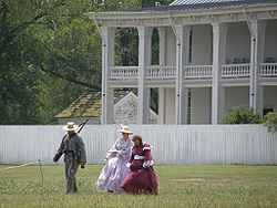
| Carnton
Carnton
Carnton is a historic plantation house and museum in Franklin in Williamson County, Tennessee. Carnton is the setting for the novel The Widow of the South, by author Robert Hicks...
|
|
| Confederate Cemetery Lane
35°54′11"N 86°51′30"W
| Franklin
Franklin, Tennessee
Franklin is a city within and the county seat of Williamson County, Tennessee, United States. The population was 62,487 as of the 2010 census Franklin is located approximately south of downtown Nashville.-History:...
| Part of the Franklin Battlefield.
|--
! | 14
| John Henry Carothers House
John Henry Carothers House
The John Henry Carothers House, also known as Ezeal Carothers House, is a property in Franklin, Tennessee that was listed on the National Register of Historic Places in 1989....
|
|
| Liberty Pike
35°55′41"N 86°49′2"W
| Franklin
Franklin, Tennessee
Franklin is a city within and the county seat of Williamson County, Tennessee, United States. The population was 62,487 as of the 2010 census Franklin is located approximately south of downtown Nashville.-History:...
|
|--
! | 15
| Cedarmont
Cedarmont
Cedarmont is a property near Franklin, Tennessee that was listed on the National Register of Historic Places in 1984. It was built or has other significance in c.1816 and c.1855....
|
|
| Off State Route 96
Tennessee State Route 96
State Route 96 is a long east–west highway in Middle Tennessee. The road begins in Dickson and ends in Granville. The current length is . Along its path it goes through 10 counties. Locals mostly refer to it as Highway 96.- Route description :...
35°53′24"N 86°48′5"W
| Franklin
Franklin, Tennessee
Franklin is a city within and the county seat of Williamson County, Tennessee, United States. The population was 62,487 as of the 2010 census Franklin is located approximately south of downtown Nashville.-History:...
|
|--
! | 16
| Coats-Hines Archaeological Site
Coats-Hines Site
The Coats-Hines Site is an archaeological site located in Williamson County, Tennessee in the Southeastern United States. The site is significant in that it is one of only a very few sites in Eastern North America that contains direct evidence of Paleoindian hunting of late Pleistocene proboscideans...
|
|
| Address Restricted
| Franklin
Franklin, Tennessee
Franklin is a city within and the county seat of Williamson County, Tennessee, United States. The population was 62,487 as of the 2010 census Franklin is located approximately south of downtown Nashville.-History:...
vicinity
| One of only a very few sites in Eastern North America that contains direct evidence of mastodon hunting by Paleoindians during the late Pleistocene
Pleistocene
The Pleistocene is the epoch from 2,588,000 to 11,700 years BP that spans the world's recent period of repeated glaciations. The name pleistocene is derived from the Greek and ....
.
|--
! | 17
| College Grove Methodist Church
College Grove Methodist Church
The College Grove Methodist Church is a building in College Grove, Tennessee that was listed on the National Register of Historic Places in 1988. It was built c.1888 and was designed and/or built by T.G. Slate....
|
|
| Alternate U.S. Route 31
U.S. Route 31
U.S. Route 31 is a long north–south highway connecting northern Michigan to southern Alabama, with its northern terminus at Interstate 75 near Mackinaw City, Michigan, and southern terminus at the combined U.S. Route 90 & U.S. Route 98 at Spanish Fort, Alabama...
35°47′16"N 86°40′25"W
| College Grove
College Grove, Tennessee
College Grove is an unincorporated town near Franklin and Murfreesboro in Williamson County, Tennessee, United States. College Grove is predominantly rural....
|
|--
! | 18
| Cox House
Cox House (Franklin, Tennessee)
Cox House is a building in Franklin, Tennessee that was listed on the National Register of Historic Places in 1980. It is associated with the Harpeth Academy....
|
|
| 150 Franklin Rd.
35°55′43"N 86°51′54"W
| Franklin
Franklin, Tennessee
Franklin is a city within and the county seat of Williamson County, Tennessee, United States. The population was 62,487 as of the 2010 census Franklin is located approximately south of downtown Nashville.-History:...
|
|--
! | 19
| John Crafton House
John Crafton House
The John Crafton House, also known as Ralroth Farm, is a property in Franklin, Tennessee that was listed on the National Register of Historic Places in 1988....
|
|
| N. Chapel Rd. 2 miles east of Arno Rd.
35°52′44"N 86°46′10"W
| Franklin
Franklin, Tennessee
Franklin is a city within and the county seat of Williamson County, Tennessee, United States. The population was 62,487 as of the 2010 census Franklin is located approximately south of downtown Nashville.-History:...
|
|--
! | 20
| Craig-Beasley House
Craig-Beasley House
The Craig-Beasley House, also known as Gaines House, is a property in Franklin, Tennessee that was listed on the National Register of Historic Places in 2003....
|
|
| 503 Boyd Mill Ave.
35°55′22"N 86°52′54"W
| Franklin
Franklin, Tennessee
Franklin is a city within and the county seat of Williamson County, Tennessee, United States. The population was 62,487 as of the 2010 census Franklin is located approximately south of downtown Nashville.-History:...
|
|--
! | 21
| Jacob Critz House
Jacob Critz House
The Jacob Critz House is a ca. 1835 center-hall house in Thompsons Station, Tennessee.It was listed on the National Register of Historic Places in 1988. When listed the property included one contributing building, one non-contributing building, and one non-contributing structure, on...
|
|
| Evergreen Rd. 1½ miles east of Pope Chapel Rd.
35°47′56"N 86°56′44"W
| Thompson's Station
Thompson's Station, Tennessee
Thompson's Station is a town in Williamson County, Tennessee, United States. The population was 1,283 at the 2000 census. It is the location of two places listed on the U.S. National Register of Historic Places: the Jacob Critz House and the Thomas L. Critz House.-Geography:Thompson's Station is...
|
|--
! | 22
| Thomas L. Critz House
Thomas L. Critz House
The Thomas L. Critz House, built c.1887, is a historic Italianate style house in Thompsons Station, Tennessee that was listed on the National Register of Historic Places in 1988. It includes Central passage plan architecture....
|
|
| Critz Ln. 1 mile east of Columbia Pike/U.S. Route 31
U.S. Route 31
U.S. Route 31 is a long north–south highway connecting northern Michigan to southern Alabama, with its northern terminus at Interstate 75 near Mackinaw City, Michigan, and southern terminus at the combined U.S. Route 90 & U.S. Route 98 at Spanish Fort, Alabama...
35°48′38"N 86°52′50"W
| Thompson's Station
Thompson's Station, Tennessee
Thompson's Station is a town in Williamson County, Tennessee, United States. The population was 1,283 at the 2000 census. It is the location of two places listed on the U.S. National Register of Historic Places: the Jacob Critz House and the Thomas L. Critz House.-Geography:Thompson's Station is...
|
|--
! | 23
| Andrew Crockett House
Andrew Crockett House
The Andrew Crockett House, also known as the Crockett-Knox House, is a property in Brentwood, Tennessee that was listed on the National Register of Historic Places in 1988....
|
|
| 8230 Wikle Ln.
35°59′1"N 86°47′2"W
| Brentwood
Brentwood, Tennessee
-Demographics:As of the census of 2000, there were 23,445 people, 7,693 households, and 6,808 families residing in the city. The population density was . There were 7,889 housing units at an average density of . The racial makeup of the city was 94.63% European American, 1.89% African American,...
|
|--
! | 24
| Samuel Crockett House
Samuel Crockett House
The Samuel Crockett House, also known as Forge Seat, is a property in Brentwood, Tennessee that was listed on the National Register of Historic Places in 1988. It was home of Samuel Crockett, son of Andrew Crockett, whose home is also NRHP-listed as Andrew Crockett House...
|
|
| Crockett Rd. and Wilson Pike
35°58′30"N 86°46′30"W
| Brentwood
Brentwood, Tennessee
-Demographics:As of the census of 2000, there were 23,445 people, 7,693 households, and 6,808 families residing in the city. The population density was . There were 7,889 housing units at an average density of . The racial makeup of the city was 94.63% European American, 1.89% African American,...
|
|--
! | 25
| Stokely Davis House
Stokely Davis House
The Stokely Davis House was built in 1850 and includes Italianate architecture and Greek Revival architectureThe house is among the best two-story vernacular I-house examples in the county The Stokely Davis House was built in 1850 and includes Italianate architecture and Greek Revival...
|
|
| Old Natchez Trace 1 mile south of Moran Rd.
36°0′2"N 86°56′13"W
| Franklin
Franklin, Tennessee
Franklin is a city within and the county seat of Williamson County, Tennessee, United States. The population was 62,487 as of the 2010 census Franklin is located approximately south of downtown Nashville.-History:...
|
|--
! | 26
| Dortch Stove Works
Dortch Stove Works
The Dortch Stove Works is an industrial property in Franklin, Tennessee. It also has been known as Allen Manufacturing Company, as Magic Chef Inc., and as Jamison Bedding. Now known as The Factory at Franklin, it is a retail shopping mall with 83 tenants.The property was listed on the National...
|
|
| 230 N. Franklin Rd.
35°55′58"N 86°47′36"W
| Franklin
Franklin, Tennessee
Franklin is a city within and the county seat of Williamson County, Tennessee, United States. The population was 62,487 as of the 2010 census Franklin is located approximately south of downtown Nashville.-History:...
|
|--
! | 27
| Douglass-Reams House
Douglass-Reams House
Douglass-Reams House is a ca. 1828 center-hall house in Franklin, Tennessee.It was listed on the National Register of Historic Places in 1988. The notability of the property was mentioned in a 1988 study of Williamson County historical resources:...
|
|
| Henpeck Ln. ¼ mile west of Lewisburg Pike
35°52′28"N 86°50′59"W
| Franklin
Franklin, Tennessee
Franklin is a city within and the county seat of Williamson County, Tennessee, United States. The population was 62,487 as of the 2010 census Franklin is located approximately south of downtown Nashville.-History:...
|
|--
! | 28
| Joseph Elliston House
Joseph Elliston House
The Joseph Elliston House, also known as the Cohen House, is a ca. 1817 center-hall house in Brentwood, Tennessee.It was listed on the National Register of Historic Places in 1988. When listed the property included one contributing building, two non-contributing buildings, and one non-contributing...
|
|
| Hillsboro Rd./U.S. Route 431
U.S. Route 431
U.S. Route 431 is a spur of U.S. Route 31. It currently runs for 556 miles from Owensboro, Kentucky at U.S. Route 60 to Dothan, Alabama, at U.S. Route 231 and U.S. Route 84. Through many parts of US 431 it is a two lane with not many places of it being a four lane highway.-Alabama:U.S. 431 is...
1 mile north of Sneed Rd.
36°1′50"N 86°52′33"W
| Brentwood
Brentwood, Tennessee
-Demographics:As of the census of 2000, there were 23,445 people, 7,693 households, and 6,808 families residing in the city. The population density was . There were 7,889 housing units at an average density of . The racial makeup of the city was 94.63% European American, 1.89% African American,...
|
|--
! | 29
| Fewkes Group Archaeological Site
Fewkes Group Archaeological Site
Fewkes Group Archaeological Site , also known as the Boiling Springs Site, is a prehistoric Native American archaeological site located in the city of Brentwood, in Williamson County, Tennessee. It is in Primm Historic Park on the grounds of Boiling Spring Academy, a historic schoolhouse...
|
|
| Located in Primm Historic Park on the grounds of Boiling Spring Academy
35°58′.44"N 86°46′34.54"W
| Brentwood
Brentwood, Tennessee
-Demographics:As of the census of 2000, there were 23,445 people, 7,693 households, and 6,808 families residing in the city. The population density was . There were 7,889 housing units at an average density of . The racial makeup of the city was 94.63% European American, 1.89% African American,...
| A Mississippian culture
Mississippian culture
The Mississippian culture was a mound-building Native American culture that flourished in what is now the Midwestern, Eastern, and Southeastern United States from approximately 800 CE to 1500 CE, varying regionally....
archaeological site
Archaeological site
An archaeological site is a place in which evidence of past activity is preserved , and which has been, or may be, investigated using the discipline of archaeology and represents a part of the archaeological record.Beyond this, the definition and geographical extent of a 'site' can vary widely,...
located in the city of Brentwood. The 15-acre site consists of the remains of a mound
Platform mound
A platform mound is any earthwork or mound intended to support a structure or activity.-Eastern North America:The indigenous peoples of North America built substructure mounds for well over a thousand years starting in the Archaic period and continuing through the Woodland period...
complex and village roughly dating to 1050-1475.
|--
! | 30
| Forest Hills School
Forest Hills School (Franklin, Tennessee)
The Forest Hills School in Franklin, Tennessee was built in 1907. Along with Liberty School and Liberty Hill School, it is one of the three best surviving examples in Williamson County of one room schoolhouses built during 1900-1920...
|
|
| Carters Creek Pike 1/5 mile south of Bear Creek Rd.
35°51′51"N 86°57′15"W
| Franklin
Franklin, Tennessee
Franklin is a city within and the county seat of Williamson County, Tennessee, United States. The population was 62,487 as of the 2010 census Franklin is located approximately south of downtown Nashville.-History:...
|
|--
! | 31
| Fort Granger
Fort Granger
Fort Granger is a property in Franklin, Tennessee that is a City of Franklin park, in the central Franklin area. It was part of American Civil War fortifications of Franklin and includes trenches dug by Civil War soldiers.It was built in 1862...
|
|
| Off Liberty Pike
35°55′33"N 86°51′38"W
| Franklin
Franklin, Tennessee
Franklin is a city within and the county seat of Williamson County, Tennessee, United States. The population was 62,487 as of the 2010 census Franklin is located approximately south of downtown Nashville.-History:...
|
|--
! | 32
| Franklin Battlefield
Franklin Battlefield
Franklin Battlefield was the site of the Second Battle of Franklin, which occurred late in the American Civil War. It is located in the southern part of Franklin, Tennessee, on U.S. 31. It was declared a National Historic Landmark in 1960....
|

|
| South of Franklin on U.S. Route 31
U.S. Route 31
U.S. Route 31 is a long north–south highway connecting northern Michigan to southern Alabama, with its northern terminus at Interstate 75 near Mackinaw City, Michigan, and southern terminus at the combined U.S. Route 90 & U.S. Route 98 at Spanish Fort, Alabama...
35°54′13"N 86°51′58"W
| Franklin
Franklin, Tennessee
Franklin is a city within and the county seat of Williamson County, Tennessee, United States. The population was 62,487 as of the 2010 census Franklin is located approximately south of downtown Nashville.-History:...
|
|--
! | 33
| Franklin Historic District
Franklin Historic District (Franklin, Tennessee)
Franklin Historic District is a historic district in Franklin, Tennessee that was listed on the National Register of Historic Places in 1972. It was created to preserve historic commercial and residential architecture in a 16-block area of the original, downtown Franklin around the north, west,...
|
|
| Centered around Main St. (State Route 96
Tennessee State Route 96
State Route 96 is a long east–west highway in Middle Tennessee. The road begins in Dickson and ends in Granville. The current length is . Along its path it goes through 10 counties. Locals mostly refer to it as Highway 96.- Route description :...
) and 3rd Ave. (U.S. Route 31
U.S. Route 31
U.S. Route 31 is a long north–south highway connecting northern Michigan to southern Alabama, with its northern terminus at Interstate 75 near Mackinaw City, Michigan, and southern terminus at the combined U.S. Route 90 & U.S. Route 98 at Spanish Fort, Alabama...
); also 3rd Ave., S. between S. Margin St. and the railroad line; also the 300 block of 4th Ave., S.
35°55′30"N 86°52′9"W
| Franklin
Franklin, Tennessee
Franklin is a city within and the county seat of Williamson County, Tennessee, United States. The population was 62,487 as of the 2010 census Franklin is located approximately south of downtown Nashville.-History:...
| 3rd Ave. addresses represent a boundary increase of ; 300 block of 4th Ave. represents a boundary increase of
|--
! | 34
| John Frost House
|
|
| Old Smyrna Rd. 1½ miles east of Wilson Pike
36°1′6"N 86°45′27"W
| Brentwood
Brentwood, Tennessee
-Demographics:As of the census of 2000, there were 23,445 people, 7,693 households, and 6,808 families residing in the city. The population density was . There were 7,889 housing units at an average density of . The racial makeup of the city was 94.63% European American, 1.89% African American,...
|
|--
! | 35
| James Giddens House
|
|
| Farm Ln. at the northern boundary of Thompson's Station
35°48′2"N 86°55′16"W
| Thompson's Station
Thompson's Station, Tennessee
Thompson's Station is a town in Williamson County, Tennessee, United States. The population was 1,283 at the 2000 census. It is the location of two places listed on the U.S. National Register of Historic Places: the Jacob Critz House and the Thomas L. Critz House.-Geography:Thompson's Station is...
|
|--
! | 36
| Samuel F. Glass House
|
|
| State Route 96
Tennessee State Route 96
State Route 96 is a long east–west highway in Middle Tennessee. The road begins in Dickson and ends in Granville. The current length is . Along its path it goes through 10 counties. Locals mostly refer to it as Highway 96.- Route description :...
at Boyd Mill Pike
35°56′13"N 86°55′39"W
| Franklin
Franklin, Tennessee
Franklin is a city within and the county seat of Williamson County, Tennessee, United States. The population was 62,487 as of the 2010 census Franklin is located approximately south of downtown Nashville.-History:...
|
|--
! | 37
| Glen Echo
Glen Echo (Franklin, Tennessee)
Glen Echo, also known as Harpeth Hall, is a property in Franklin, Tennessee that was listed on the National Register of Historic Places in 1976. It is a former plantation house that is now the centerpiece and administrative office of the Battle Ground Academy campus in Franklin, Tennessee.It was...
|
|
| North of Franklin off U.S. Route 31
U.S. Route 31
U.S. Route 31 is a long north–south highway connecting northern Michigan to southern Alabama, with its northern terminus at Interstate 75 near Mackinaw City, Michigan, and southern terminus at the combined U.S. Route 90 & U.S. Route 98 at Spanish Fort, Alabama...
on Spencer Creek Rd.
35°57′0"N 86°51′29"W
| Franklin
Franklin, Tennessee
Franklin is a city within and the county seat of Williamson County, Tennessee, United States. The population was 62,487 as of the 2010 census Franklin is located approximately south of downtown Nashville.-History:...
|
|--
! | 38
| Abram Glenn House
|
|
| McCanless Rd. 1½ miles east of Alternate U.S. Route 41
U.S. Route 41
U.S. Route 41 is a north–south United States Highway that runs from Miami, Florida to the Upper Peninsula of Michigan. Until 1949, the part in southern Florida, from Naples to Miami, was U.S...
35°53′0"N 86°38′2"W
| Triune
Triune, Tennessee
Triune is an unincorporated community in eastern Williamson County, Tennessee, United States, approximately halfway between Franklin and Murfreesboro. The community is located along the Wilson Branch of the Harpeth River and at the intersection of Tennessee State Route 96 and the concurrency of U.S...
|
|--
! | 39
| Henry P. Gray House
Henry P. Gray House
The Henry P. Gray House is a building in Franklin, Tennessee dating from c.1845. It was listed on the National Register of Historic Places in 1988...
|
|
| Old Hillsboro Rd. at Boyd Mill Rd.
35°55′30"N 86°58′21"W
| Franklin
Franklin, Tennessee
Franklin is a city within and the county seat of Williamson County, Tennessee, United States. The population was 62,487 as of the 2010 census Franklin is located approximately south of downtown Nashville.-History:...
|
|--
! | 40
| Sherwood Green House
Sherwood Green House
The Sherwood Green House is a property in Nolensville, Tennessee that was listed on the National Register of Historic Places in 1988.The property is also known as WM-194....
|
|
| Rocky Fork Rd. ½ mile east of Nolensville
35°57′12"N 86°39′30"W
| Nolensville
Nolensville, Tennessee
Nolensville is a town in Williamson County, Tennessee, United States. The population was 3,099 at the 2000 census.-Geography:Nolensville is located at ....
|
|--
! | 41
| Denny P. Hadley House
|
|
| Off U.S. Route 31
U.S. Route 31
U.S. Route 31 is a long north–south highway connecting northern Michigan to southern Alabama, with its northern terminus at Interstate 75 near Mackinaw City, Michigan, and southern terminus at the combined U.S. Route 90 & U.S. Route 98 at Spanish Fort, Alabama...
/Franklin Rd. south of Brentwood
36°0′36"N 86°47′34"W
| Brentwood
Brentwood, Tennessee
-Demographics:As of the census of 2000, there were 23,445 people, 7,693 households, and 6,808 families residing in the city. The population density was . There were 7,889 housing units at an average density of . The racial makeup of the city was 94.63% European American, 1.89% African American,...
|
|--
! | 42
| Hamilton-Brown House
Hamilton-Brown House
The Hamilton-Brown House, in Franklin, Tennessee, also known as the Elijah Hamilton House or as Cottonwood, is a historic house that was listed on the National Register of Historic Places in 2006....
|
|
| 845 Old Charlotte Pike
35°56′15"N 86°55′7"W
| Franklin
Franklin, Tennessee
Franklin is a city within and the county seat of Williamson County, Tennessee, United States. The population was 62,487 as of the 2010 census Franklin is located approximately south of downtown Nashville.-History:...
|
|--
! | 43
| Franklin Hardeman House
Franklin Hardeman House
The Franklin Hardeman House is a property in Franklin, Tennessee that was listed on the National Register of Historic Places in 1988. The property is also known as Sugar Hill and is denoted as Williamson County historic resource WM-291....
|
|
| Lewisburg Pike 1 mile south of Goose Creek Bypass
35°50′46"N 86°50′43"W
| Franklin
Franklin, Tennessee
Franklin is a city within and the county seat of Williamson County, Tennessee, United States. The population was 62,487 as of the 2010 census Franklin is located approximately south of downtown Nashville.-History:...
|
|--
! | 44
| Harlinsdale Farm
|
|
| 239 Franklin Rd.
35°56′36"N 86°51′57"W
| Franklin
Franklin, Tennessee
Franklin is a city within and the county seat of Williamson County, Tennessee, United States. The population was 62,487 as of the 2010 census Franklin is located approximately south of downtown Nashville.-History:...
|
|--
! | 45
| Harpeth Furnace (40WM83)
|
|
| Address Restricted
| Fernvale
|
|--
! | 46
| Harrison House
|
|
| South of Franklin on Columbia Pike
35°52′56"N 86°52′51"W
| Franklin
Franklin, Tennessee
Franklin is a city within and the county seat of Williamson County, Tennessee, United States. The population was 62,487 as of the 2010 census Franklin is located approximately south of downtown Nashville.-History:...
|
|--
! | 47
| John Herbert House
John Herbert House
The John Herbert House, also known as Breezeway, is a property in Franklin, Tennessee that was listed on the National Register of Historic Places in 1988....
|
|
| Clovercroft Rd. ¾ mile east of Wilson Pike
35°55′51"N 86°45′21"W
| Franklin
Franklin, Tennessee
Franklin is a city within and the county seat of Williamson County, Tennessee, United States. The population was 62,487 as of the 2010 census Franklin is located approximately south of downtown Nashville.-History:...
|
|--
! | 48
| Hincheyville Historic District
Hincheyville Historic District
Hincheyville Historic District is a historic district in Franklin, Tennessee that was listed on the National Register of Historic Places in 1982. It was Franklin's first residential historic district.St...
|
|
| W. Main, Fair, 6th, 7th, 8th, 9th, and 10th Sts.
35°55′21"N 86°52′34"W
| Franklin
Franklin, Tennessee
Franklin is a city within and the county seat of Williamson County, Tennessee, United States. The population was 62,487 as of the 2010 census Franklin is located approximately south of downtown Nashville.-History:...
|
|--
! | 49
| Hiram Masonic Lodge No. 7
Hiram Masonic Lodge No. 7
Hiram Masonic Lodge No. 7, a Gothic revival building constructed in 1823, is the oldest public building in Franklin, Tennessee. It houses Hiram Lodge No. 7, founded in 1809, and is the oldest Masonic Hall in continuous use in Tennessee...
|
|
| S. 2nd Ave.
35°55′32"N 86°52′14"W
| Franklin
Franklin, Tennessee
Franklin is a city within and the county seat of Williamson County, Tennessee, United States. The population was 62,487 as of the 2010 census Franklin is located approximately south of downtown Nashville.-History:...
|
|--
! | 50
| Robert Hodge House
Robert Hodge House
The Robert Hodge House, also known as Sullivan Farm House, is a ca. 1900 Queen Anne and Colonial Revival house in Franklin, Tennessee.It was listed on the National Register of Historic Places in 2005...
|
|
| 409 Madison Court
35°53′26"N 86°51′12"W
| Franklin
Franklin, Tennessee
Franklin is a city within and the county seat of Williamson County, Tennessee, United States. The population was 62,487 as of the 2010 census Franklin is located approximately south of downtown Nashville.-History:...
|
|--
! | 51
| Thomas Holt House
|
|
| Crockett Rd. 1 mile east of Wilson Pike
35°58′30"N 86°45′50"W
| Brentwood
Brentwood, Tennessee
-Demographics:As of the census of 2000, there were 23,445 people, 7,693 households, and 6,808 families residing in the city. The population density was . There were 7,889 housing units at an average density of . The racial makeup of the city was 94.63% European American, 1.89% African American,...
|
|--
! | 52
| Homestead Manor
|
|
| North of Thompson's Station on U.S. Route 31
U.S. Route 31
U.S. Route 31 is a long north–south highway connecting northern Michigan to southern Alabama, with its northern terminus at Interstate 75 near Mackinaw City, Michigan, and southern terminus at the combined U.S. Route 90 & U.S. Route 98 at Spanish Fort, Alabama...
35°48′23"N 86°54′9"W
| Thompson's Station
Thompson's Station, Tennessee
Thompson's Station is a town in Williamson County, Tennessee, United States. The population was 1,283 at the 2000 census. It is the location of two places listed on the U.S. National Register of Historic Places: the Jacob Critz House and the Thomas L. Critz House.-Geography:Thompson's Station is...
|
|--
! | 53
| Huff Store
Huff Store
Huff Store is a property in Burwood, Tennessee that was listed on the National Register of Historic Places in 1988.The store was bought by Glenn Huff in 1949.The property was covered in a 1988 study of Williamson County historical resources....
|
|
| Carters Creek Pike
35°48′44"N 86°58′59"W
| Burwood
Burwood, Tennessee
Burwood, Tennessee is a community in Williamson County, Tennessee. It is the location of the John Pope House , which is listed on the U.S. National Register of Historic Places.-References:...
|
|--
! | 54
| John Hunter House
John Hunter House (Franklin, Tennessee)
The John Hunter House, also known as McCullough House, is an Italianate style house that was built in 1875 near Franklin, Williamson County, Tennessee. It was listed on the National Register of Historic Places in 1988. The listed property has an area of ....
|
|
| Old State Route 96
Tennessee State Route 96
State Route 96 is a long east–west highway in Middle Tennessee. The road begins in Dickson and ends in Granville. The current length is . Along its path it goes through 10 counties. Locals mostly refer to it as Highway 96.- Route description :...
at Carl Rd.
35°52′48"N 86°58′33"W
| Franklin
Franklin, Tennessee
Franklin is a city within and the county seat of Williamson County, Tennessee, United States. The population was 62,487 as of the 2010 census Franklin is located approximately south of downtown Nashville.-History:...
|
|--
! | 55
| Hartwell B. Hyde House
Hartwell B. Hyde House
The Hartwell B. Hyde House, also known as Solitude, is a property in Triune, Tennessee that was listed on the National Register of Historic Places in 1988.Hartwell Hyde was an early settler of the Triune area...
|
|
| State Route 96
Tennessee State Route 96
State Route 96 is a long east–west highway in Middle Tennessee. The road begins in Dickson and ends in Granville. The current length is . Along its path it goes through 10 counties. Locals mostly refer to it as Highway 96.- Route description :...
, 1 mile east of Alternate U.S. Route 41
U.S. Route 41
U.S. Route 41 is a north–south United States Highway that runs from Miami, Florida to the Upper Peninsula of Michigan. Until 1949, the part in southern Florida, from Naples to Miami, was U.S...
35°51′18"N 86°37′57"W
| Triune
Triune, Tennessee
Triune is an unincorporated community in eastern Williamson County, Tennessee, United States, approximately halfway between Franklin and Murfreesboro. The community is located along the Wilson Branch of the Harpeth River and at the intersection of Tennessee State Route 96 and the concurrency of U.S...
|
|--
! | 56
| James P. Johnson House
|
|
| U.S. Route 31
U.S. Route 31
U.S. Route 31 is a long north–south highway connecting northern Michigan to southern Alabama, with its northern terminus at Interstate 75 near Mackinaw City, Michigan, and southern terminus at the combined U.S. Route 90 & U.S. Route 98 at Spanish Fort, Alabama...
3/10 mile south of W. Harpeth Rd.
35°50′29"N 86°52′58"W
| Thompson's Station
Thompson's Station, Tennessee
Thompson's Station is a town in Williamson County, Tennessee, United States. The population was 1,283 at the 2000 census. It is the location of two places listed on the U.S. National Register of Historic Places: the Jacob Critz House and the Thomas L. Critz House.-Geography:Thompson's Station is...
|
|--
! | 57
| William W. Johnson House
William W. Johnson House
The William W. Johnson House in Franklin, Tennessee, along with the James Scales House, another Williamson County house, are notable as late 19th century central passage plan residences that "display period decoration at eaves and porch." It has been described as I-house architecture.The property,...
|
|
| Farm Ln. ½ mile south of Clovercroft Rd. and ½ mile east of Pleasant Hill Rd.
35°55′43"N 86°42′35"W
| Franklin
Franklin, Tennessee
Franklin is a city within and the county seat of Williamson County, Tennessee, United States. The population was 62,487 as of the 2010 census Franklin is located approximately south of downtown Nashville.-History:...
|
|--
! | 58
| James Johnston House
|
|
| South of Brentwood on U.S. Route 31
U.S. Route 31
U.S. Route 31 is a long north–south highway connecting northern Michigan to southern Alabama, with its northern terminus at Interstate 75 near Mackinaw City, Michigan, and southern terminus at the combined U.S. Route 90 & U.S. Route 98 at Spanish Fort, Alabama...
35°59′47"N 86°48′34"W
| Brentwood
Brentwood, Tennessee
-Demographics:As of the census of 2000, there were 23,445 people, 7,693 households, and 6,808 families residing in the city. The population density was . There were 7,889 housing units at an average density of . The racial makeup of the city was 94.63% European American, 1.89% African American,...
|
|--
! | 59
| Newton Jordan House
Newton Jordan House
The Newton Jordan House is a property in Triune, Tennessee that was listed on the National Register of Historic Places in 1988. It was built, remodelled, or has other significance in c. 1830 and c. 1900...
|
|
| New Rd. 1 mile east of Alternate U.S. Route 41
U.S. Route 41
U.S. Route 41 is a north–south United States Highway that runs from Miami, Florida to the Upper Peninsula of Michigan. Until 1949, the part in southern Florida, from Naples to Miami, was U.S...
35°48′58"N 86°38′42"W
| Triune
Triune, Tennessee
Triune is an unincorporated community in eastern Williamson County, Tennessee, United States, approximately halfway between Franklin and Murfreesboro. The community is located along the Wilson Branch of the Harpeth River and at the intersection of Tennessee State Route 96 and the concurrency of U.S...
|
|--
! | 60
| Jordan-Williams House
Jordan-Williams House
The Jordan-Williams House is an Italianate style house in Nolensville, Tennessee that was listed on the National Register of Historic Places in 1988....
|
|
| Rocky Fork Rd. 2 miles east of Nolensville
35°56′36"N 86°37′14"W
| Nolensville
Nolensville, Tennessee
Nolensville is a town in Williamson County, Tennessee, United States. The population was 3,099 at the 2000 census.-Geography:Nolensville is located at ....
|
|--
! | 61
| Claiborne Kinnard House
|
|
| Carters Creek Pike ½ mile north of Bear Creek Rd.
35°52′20"N 86°56′31"W
| Franklin
Franklin, Tennessee
Franklin is a city within and the county seat of Williamson County, Tennessee, United States. The population was 62,487 as of the 2010 census Franklin is located approximately south of downtown Nashville.-History:...
|
|--
! | 62
| Knight-Moran House
Knight-Moran House
The Knight-Moran House, near Franklin, Tennessee, was built in 1820. Also known as Woodland, and denoted as WM-44. It was listed on the National Register of Historic Places in 1988....
|
|
| Off Old Natchez Trace 1/10 mile south of Moran Rd.
36°0′55"N 86°56′18"W
| Franklin
Franklin, Tennessee
Franklin is a city within and the county seat of Williamson County, Tennessee, United States. The population was 62,487 as of the 2010 census Franklin is located approximately south of downtown Nashville.-History:...
|
|--
! | 63
| Knights of Pythias Pavilion
Knights of Pythias Pavilion
The Knights of Pythias Pavilion in Franklin, Tennessee, also known as Carlisle House, is a Classical Revival architecture building designed by Henry Gibel and built in 1897...
|
|
| State Route 96
Tennessee State Route 96
State Route 96 is a long east–west highway in Middle Tennessee. The road begins in Dickson and ends in Granville. The current length is . Along its path it goes through 10 counties. Locals mostly refer to it as Highway 96.- Route description :...
35°55′57"N 86°54′30"W
| Franklin
Franklin, Tennessee
Franklin is a city within and the county seat of Williamson County, Tennessee, United States. The population was 62,487 as of the 2010 census Franklin is located approximately south of downtown Nashville.-History:...
|
|--
! | 64
| William Leaton House
|
|
| Hillsboro Rd./U.S. Route 431
U.S. Route 431
U.S. Route 431 is a spur of U.S. Route 31. It currently runs for 556 miles from Owensboro, Kentucky at U.S. Route 60 to Dothan, Alabama, at U.S. Route 231 and U.S. Route 84. Through many parts of US 431 it is a two lane with not many places of it being a four lane highway.-Alabama:U.S. 431 is...
at Manely Ln.
36°0′40"N 86°53′21"W
| Franklin
Franklin, Tennessee
Franklin is a city within and the county seat of Williamson County, Tennessee, United States. The population was 62,487 as of the 2010 census Franklin is located approximately south of downtown Nashville.-History:...
|
|--
! | 65
| Samuel B. Lee House
|
|
| Duplex Rd. ½ mile west of Lewisburg Pike; also 3085 Duplex-Spring Hill Rd.
35°44′35"N 86°50′44"W
| Duplex
| 3085 Duplex-Spring Hill represents a boundary increase, "Maplewood Farm (Boundary Increase)"
|--
! | 66
| Leipers Fork Historic District
|
|
| Roughly bounded by Joseph St., Old State Route 96
Tennessee State Route 96
State Route 96 is a long east–west highway in Middle Tennessee. The road begins in Dickson and ends in Granville. The current length is . Along its path it goes through 10 counties. Locals mostly refer to it as Highway 96.- Route description :...
, Old Hillsboro Rd., and Sycamore St.
35°53′46"N 86°59′57"W
| Leiper's Fork
Leiper's Fork, Tennessee
Leiper's Fork is an unincorporated village in Williamson County, Tennessee, United States. It is located at .The village, located on the Natchez Trace Parkway, is listed on the National Register of Historic Places as a historic district containing examples of late 19th century architecture.The area...
|
|--
! | 67
| Lewisburg Avenue Historic District
Lewisburg Avenue Historic District
Lewisburg Avenue Historic District is a historic district in Franklin, Tennessee that was listed on the National Register of Historic Places in 1988 .It includes Late 19th and 20th Century Revivals, Bungalow/Craftsman, and Late Victorian architecture....
|
|
| Roughly bounded by S. Margin St., Lewisburg Ave., and Adams St.
35°55′4"N 86°52′10"W
| Franklin
Franklin, Tennessee
Franklin is a city within and the county seat of Williamson County, Tennessee, United States. The population was 62,487 as of the 2010 census Franklin is located approximately south of downtown Nashville.-History:...
|
|--
! | 68
| Liberty Hill School
Liberty Hill School (Liberty Hill, Tennessee)
The Liberty Hill School at Liberty Hill, near Fairview, Tennessee, was built c. 1915. Along with Forest Hills School and Liberty School, as of 1988 it was considered one of the three best surviving examples in Williamson County of one room schoolhouses built during 1900-1920...
|
|
| Crow Cut Rd.
35°58′41"N 87°10′53"W
| Liberty Hill
Liberty Hill, Tennessee
Liberty Hill is a place in Williamson County, Tennessee, United States. It is the location of the Liberty Hill School, which is listed on the U.S. National Register of Historic Places.-References:...
|
|--
! | 69
| Lotz House
Lotz House
The Lotz House is a building in Franklin, Tennessee that was built in 1858. It was listed on the National Register of Historic Places in 1976.- History and the Battle of Franklin :...
|
|
| 1111 Columbia Ave.
35°55′4"N 86°52′22"W
| Franklin
Franklin, Tennessee
Franklin is a city within and the county seat of Williamson County, Tennessee, United States. The population was 62,487 as of the 2010 census Franklin is located approximately south of downtown Nashville.-History:...
|
|--
! | 70
| Maney-Sidway House
Maney-Sidway House
The Maney-Sidway House, also known as Jasmine Grove and as Myles Manor, is a building in Franklin, Tennessee originally built c.1836, that was listed on the National Register of Historic Places in 1988....
|
|
| Myles Manor Ct. west of Franklin Rd./U.S. Route 31
U.S. Route 31
U.S. Route 31 is a long north–south highway connecting northern Michigan to southern Alabama, with its northern terminus at Interstate 75 near Mackinaw City, Michigan, and southern terminus at the combined U.S. Route 90 & U.S. Route 98 at Spanish Fort, Alabama...
35°56′1"N 86°51′58"W
| Franklin
Franklin, Tennessee
Franklin is a city within and the county seat of Williamson County, Tennessee, United States. The population was 62,487 as of the 2010 census Franklin is located approximately south of downtown Nashville.-History:...
|
|--
! | 71
| William Martin House
|
|
| 5215 Seward Rd.
36°1′34"N 86°48′23"W
| Brentwood
Brentwood, Tennessee
-Demographics:As of the census of 2000, there were 23,445 people, 7,693 households, and 6,808 families residing in the city. The population density was . There were 7,889 housing units at an average density of . The racial makeup of the city was 94.63% European American, 1.89% African American,...
|
|--
! | 72
| H.G.W. Mayberry House
|
|
| Bear Creek Rd. ½ mile west of Carters Creek Pike
35°52′9"N 86°58′7"W
| Franklin
Franklin, Tennessee
Franklin is a city within and the county seat of Williamson County, Tennessee, United States. The population was 62,487 as of the 2010 census Franklin is located approximately south of downtown Nashville.-History:...
|
|--
! | 73
| Henry H. Mayberry House
Henry H. Mayberry House
The Henry H. Mayberry House, also known as Splendored and as Riverview is a building in Franklin, Tennessee that was listed on the National Register of Historic Places in 1988....
|
|
| U.S. Route 31
U.S. Route 31
U.S. Route 31 is a long north–south highway connecting northern Michigan to southern Alabama, with its northern terminus at Interstate 75 near Mackinaw City, Michigan, and southern terminus at the combined U.S. Route 90 & U.S. Route 98 at Spanish Fort, Alabama...
just across the Harpeth River
Harpeth River
The Harpeth River, long, is one of the major streams of north-central Middle Tennessee and one of the major tributaries of the Cumberland River...
north of Franklin
35°55′46"N 86°52′2"W
| Franklin
Franklin, Tennessee
Franklin is a city within and the county seat of Williamson County, Tennessee, United States. The population was 62,487 as of the 2010 census Franklin is located approximately south of downtown Nashville.-History:...
|
|--
! | 74
| David McEwen House
|
|
| Off the eastern side of Franklin Rd./U.S. Route 31
U.S. Route 31
U.S. Route 31 is a long north–south highway connecting northern Michigan to southern Alabama, with its northern terminus at Interstate 75 near Mackinaw City, Michigan, and southern terminus at the combined U.S. Route 90 & U.S. Route 98 at Spanish Fort, Alabama...
2/10 mile north of Spencer Creek Rd.
35°56′41"N 86°50′14"W
| Franklin
Franklin, Tennessee
Franklin is a city within and the county seat of Williamson County, Tennessee, United States. The population was 62,487 as of the 2010 census Franklin is located approximately south of downtown Nashville.-History:...
|
|--
! | 75
| McGavock-Gaines House
McGavock-Gaines House
The McGavock-Gaines House is a property in Franklin, Tennessee that was listed on the National Register of Historic Places in 1988. It was remodelled in Classical Revival style in c.1920....
|
|
| Caruthers Rd. 1 mile east of Lewisburg Pike
35°54′1"N 86°50′25"W
| Franklin
Franklin, Tennessee
Franklin is a city within and the county seat of Williamson County, Tennessee, United States. The population was 62,487 as of the 2010 census Franklin is located approximately south of downtown Nashville.-History:...
|
|--
! | 76
| McLemore House
|
|
| 447 11th Ave., N.
35°55′31"N 86°52′47"W
| Franklin
Franklin, Tennessee
Franklin is a city within and the county seat of Williamson County, Tennessee, United States. The population was 62,487 as of the 2010 census Franklin is located approximately south of downtown Nashville.-History:...
|
|--
! | 77
| Daniel McMahan House
|
|
| Spencer Creek Rd. ½ mile west of Franklin Rd.
35°56′42"N 86°51′37"W
| Franklin
Franklin, Tennessee
Franklin is a city within and the county seat of Williamson County, Tennessee, United States. The population was 62,487 as of the 2010 census Franklin is located approximately south of downtown Nashville.-History:...
|
|--
! | 78
| Meeting-of-the-Waters
|
|
| Northwest of Franklin on Del Rio Pike
35°58′11"N 86°55′12"W
| Franklin
Franklin, Tennessee
Franklin is a city within and the county seat of Williamson County, Tennessee, United States. The population was 62,487 as of the 2010 census Franklin is located approximately south of downtown Nashville.-History:...
|
|--
! | 79
| Montpier
Montpier
Montpier, also known as Nicholas Perkins House, is a house built in 1821. It was listed on the National Register of Historic Places in 1982....
|
|
| Northwest of Franklin off Old Hillsboro Pike
35°58′59"N 86°56′1"W
| Franklin
Franklin, Tennessee
Franklin is a city within and the county seat of Williamson County, Tennessee, United States. The population was 62,487 as of the 2010 census Franklin is located approximately south of downtown Nashville.-History:...
|
|--
! | 80
| Mooreland
|
|
| Off U.S. Route 31
U.S. Route 31
U.S. Route 31 is a long north–south highway connecting northern Michigan to southern Alabama, with its northern terminus at Interstate 75 near Mackinaw City, Michigan, and southern terminus at the combined U.S. Route 90 & U.S. Route 98 at Spanish Fort, Alabama...
36°1′46"N 86°47′18"W
| Brentwood
Brentwood, Tennessee
-Demographics:As of the census of 2000, there were 23,445 people, 7,693 households, and 6,808 families residing in the city. The population density was . There were 7,889 housing units at an average density of . The racial makeup of the city was 94.63% European American, 1.89% African American,...
|
|--
! | 81
| George W. Morton House
|
|
| Alternate U.S. Route 41
U.S. Route 41
U.S. Route 41 is a north–south United States Highway that runs from Miami, Florida to the Upper Peninsula of Michigan. Until 1949, the part in southern Florida, from Naples to Miami, was U.S...
½ mile north of Sunset Rd.
35°57′58"N 86°40′33"W
| Nolensville
Nolensville, Tennessee
Nolensville is a town in Williamson County, Tennessee, United States. The population was 3,099 at the 2000 census.-Geography:Nolensville is located at ....
|
|--
! | 82
| Samuel S. Morton House
|
|
| Carters Creek Pike 3/10 mile north of Bear Creek Rd.
35°52′19"N 86°58′30"W
| Franklin
Franklin, Tennessee
Franklin is a city within and the county seat of Williamson County, Tennessee, United States. The population was 62,487 as of the 2010 census Franklin is located approximately south of downtown Nashville.-History:...
|
|--
! | 83
| John Motheral House
|
|
| Moran Rd. at the Harpeth River
Harpeth River
The Harpeth River, long, is one of the major streams of north-central Middle Tennessee and one of the major tributaries of the Cumberland River...
36°1′1"N 86°53′56"W
| Franklin
Franklin, Tennessee
Franklin is a city within and the county seat of Williamson County, Tennessee, United States. The population was 62,487 as of the 2010 census Franklin is located approximately south of downtown Nashville.-History:...
|
|--
! | 84
| Mountview
|
|
| 913 Franklin Rd.
36°0′19"N 86°47′45"W
| Brentwood
Brentwood, Tennessee
-Demographics:As of the census of 2000, there were 23,445 people, 7,693 households, and 6,808 families residing in the city. The population density was . There were 7,889 housing units at an average density of . The racial makeup of the city was 94.63% European American, 1.89% African American,...
|
|--
! | 85
| Natchez Street Historic District
Natchez Street Historic District
Natchez Street Historic District is a historic district in Franklin, Tennessee that was listed on the National Register of Historic Places in 2004....
|
|
| Roughly bounded by Columbia Ave., Granbury St., and W. Main St.
35°55′5"N 86°52′40"W
| Franklin
Franklin, Tennessee
Franklin is a city within and the county seat of Williamson County, Tennessee, United States. The population was 62,487 as of the 2010 census Franklin is located approximately south of downtown Nashville.-History:...
|
|--
! | 86
| John Neely House
|
|
| Sedberry Rd. 2 miles south of W. Harpeth Rd.
35°49′7"N 86°55′0"W
| Thompson's Station
Thompson's Station, Tennessee
Thompson's Station is a town in Williamson County, Tennessee, United States. The population was 1,283 at the 2000 census. It is the location of two places listed on the U.S. National Register of Historic Places: the Jacob Critz House and the Thomas L. Critz House.-Geography:Thompson's Station is...
|
|--
! | 87
| Oak Hall
|
|
| 1704 Wilson Pike
35°57′46"N 86°46′10"W
| Brentwood
Brentwood, Tennessee
-Demographics:As of the census of 2000, there were 23,445 people, 7,693 households, and 6,808 families residing in the city. The population density was . There were 7,889 housing units at an average density of . The racial makeup of the city was 94.63% European American, 1.89% African American,...
|
|--
! | 88
| Dr. Hezekiah Oden House
|
|
| Lewisburg Pike ½ mile south of Henpeck Ln.
35°51′57"N 86°50′47"W
| Franklin
Franklin, Tennessee
Franklin is a city within and the county seat of Williamson County, Tennessee, United States. The population was 62,487 as of the 2010 census Franklin is located approximately south of downtown Nashville.-History:...
|
|--
! | 89
| William Ogilvie House
|
|
| Western side of Alternate U.S. Route 31
U.S. Route 31
U.S. Route 31 is a long north–south highway connecting northern Michigan to southern Alabama, with its northern terminus at Interstate 75 near Mackinaw City, Michigan, and southern terminus at the combined U.S. Route 90 & U.S. Route 98 at Spanish Fort, Alabama...
, 1 mile south of College Grove
35°46′22"N 86°41′17"W
| College Grove
College Grove, Tennessee
College Grove is an unincorporated town near Franklin and Murfreesboro in Williamson County, Tennessee, United States. College Grove is predominantly rural....
|
|--
! | 90
| Old Natchez Trace
Natchez Trace
The Natchez Trace, also known as the "Old Natchez Trace", is a historical path that extends roughly from Natchez, Mississippi to Nashville, Tennessee, linking the Cumberland, Tennessee and Mississippi rivers...
|
|
| From the Alabama
Alabama
Alabama is a state located in the southeastern region of the United States. It is bordered by Tennessee to the north, Georgia to the east, Florida and the Gulf of Mexico to the south, and Mississippi to the west. Alabama ranks 30th in total land area and ranks second in the size of its inland...
/Tennessee border to State Route 100
Tennessee State Route 100
State Route 100 is a west–east route that connects Whiteville, Tennessee with Belle Meade, Tennessee.- Route description :Once it leaves SR-15, State Route 100 passes south of Whiteville along with US-64. Then SR-100 passes through an interchange with US-64 and SR-15 and leaves Whiteville...
in Davidson County
| Franklin
Franklin, Tennessee
Franklin is a city within and the county seat of Williamson County, Tennessee, United States. The population was 62,487 as of the 2010 census Franklin is located approximately south of downtown Nashville.-History:...
| Extends into Davidson
National Register of Historic Places listings in Davidson County, Tennessee
This is a list of the National Register of Historic Places listings in Davidson County, Tennessee.This is intended to be a complete list of the properties and districts on the National Register of Historic Places in Davidson County, Tennessee, United States...
, Hickman
National Register of Historic Places listings in Hickman County, Tennessee
This is a list of the National Register of Historic Places listings in Hickman County, Tennessee.This is intended to be a complete list of the properties and districts on the National Register of Historic Places in Hickman County, Tennessee, United States...
, Lawrence
National Register of Historic Places listings in Lawrence County, Tennessee
This is a list of the National Register of Historic Places listings in Lawrence County, Tennessee.This is intended to be a complete list of the properties and districts on the National Register of Historic Places in Lawrence County, Tennessee, United States...
, Lewis, Maury
National Register of Historic Places listings in Maury County, Tennessee
This is a list of the National Register of Historic Places listings in Maury County, Tennessee.This is intended to be a complete list of the properties and districts on the National Register of Historic Places in Maury County, Tennessee, United States...
, and Wayne counties
|--
! | 91
| Old Town (house)
Thomas Brown House (Franklin, Tennessee)
Old Town, also known as the Thomas Brown House, is a house in Franklin, Tennessee at Old Town that was built by Thomas Brown some time between 1842 and 1854. It is a two-story frame structure built on an "I-House" plan, an example of vernacular architecture showing Greek Revival influences...
|
|
| Old Natchez Trace 1½ miles south of Moran Rd.
35°59′37"N 86°56′10"W
| Franklin
Franklin, Tennessee
Franklin is a city within and the county seat of Williamson County, Tennessee, United States. The population was 62,487 as of the 2010 census Franklin is located approximately south of downtown Nashville.-History:...
| A house known also as Thomas Brown House
|--
! | 92
| Old Town Archeological Site (40WM2)
|
|
| Address Restricted
| Franklin
Franklin, Tennessee
Franklin is a city within and the county seat of Williamson County, Tennessee, United States. The population was 62,487 as of the 2010 census Franklin is located approximately south of downtown Nashville.-History:...
| Native American village and mound complex of the Mississippian culture
Mississippian culture
The Mississippian culture was a mound-building Native American culture that flourished in what is now the Midwestern, Eastern, and Southeastern United States from approximately 800 CE to 1500 CE, varying regionally....
, an archeological site
|--
! | 93
| Old Town Bridge
Old Town Bridge (Franklin, Tennessee)
The Old Town Bridge in Franklin, Tennessee was a "frame bridge across Brown Creek near its junction with the Big Harpeth River." It was built by U.S. soldiers in 1801. It carried the Harpeth River branch of the Natchez Trace over Brown's Creek. The bridge was rebuilt several times subsequently,...
|
|
| Over Brown's Creek just west of Old Natchez Trace Rd.
35°59′45"N 86°56′10"W
| Franklin
Franklin, Tennessee
Franklin is a city within and the county seat of Williamson County, Tennessee, United States. The population was 62,487 as of the 2010 census Franklin is located approximately south of downtown Nashville.-History:...
| Site of historic bridge bringing Natchez Trace
Natchez Trace
The Natchez Trace, also known as the "Old Natchez Trace", is a historical path that extends roughly from Natchez, Mississippi to Nashville, Tennessee, linking the Cumberland, Tennessee and Mississippi rivers...
branch over the Harpeth River
Harpeth River
The Harpeth River, long, is one of the major streams of north-central Middle Tennessee and one of the major tributaries of the Cumberland River...
|--
! | 94
| Owen Chapel Church of Christ
|
|
| 1101 Franklin Rd.
36°0′0"N 86°49′14"W
| Brentwood
Brentwood, Tennessee
-Demographics:As of the census of 2000, there were 23,445 people, 7,693 households, and 6,808 families residing in the city. The population density was . There were 7,889 housing units at an average density of . The racial makeup of the city was 94.63% European American, 1.89% African American,...
|
|--
! | 95
| Dr. Urban Owen House
Dr. Urban Owen House
The Dr. Urban Owen House is a property in College Grove, Tennessee that was listed on the National Register of Historic Places in 1988.When listed the property included one contributing building and one non-contributing structure on an area of ....
|
|
| Alternate U.S. Route 31
U.S. Route 31
U.S. Route 31 is a long north–south highway connecting northern Michigan to southern Alabama, with its northern terminus at Interstate 75 near Mackinaw City, Michigan, and southern terminus at the combined U.S. Route 90 & U.S. Route 98 at Spanish Fort, Alabama...
35°47′8"N 86°40′33"W
| College Grove
College Grove, Tennessee
College Grove is an unincorporated town near Franklin and Murfreesboro in Williamson County, Tennessee, United States. College Grove is predominantly rural....
|
|--
! | 96
| Owen-Cox House
Owen-Cox House
The Owen-Cox House is a property in Brentwood, Tennessee that was listed on the National Register of Historic Places in 1988. The property is also known as Maplelawn....
|
|
| Moores Ln., 1 mile east of Interstate 65
Interstate 65
Interstate 65 is a major Interstate Highway in the United States. The southern terminus is located at an intersection with Interstate 10 in Mobile, Alabama, and its northern terminus is at an interchange with Interstate 90 , U.S. Route 12, and U.S...
35°57′55"N 86°47′18"W
| Brentwood
Brentwood, Tennessee
-Demographics:As of the census of 2000, there were 23,445 people, 7,693 households, and 6,808 families residing in the city. The population density was . There were 7,889 housing units at an average density of . The racial makeup of the city was 94.63% European American, 1.89% African American,...
|
|--
! | 97
| Owen-Primm House
Owen-Primm House
The Owen-Primm House was originally a log cabin built by Jabez Owen in 1806, and later expanded with wood framing by Thomas Perkins Primm in 1845. This property in Brentwood, Tennessee was listed on the National Register of Historic Places in 1988.Dr...
|
|
| Moores Ln. at Wilson Pike
35°58′1"N 86°46′46"W
| Brentwood
Brentwood, Tennessee
-Demographics:As of the census of 2000, there were 23,445 people, 7,693 households, and 6,808 families residing in the city. The population density was . There were 7,889 housing units at an average density of . The racial makeup of the city was 94.63% European American, 1.89% African American,...
|
|--
! | 98
| Parks Place
|
|
| Cox Rd.
35°48′53"N 86°40′11"W
| College Grove
College Grove, Tennessee
College Grove is an unincorporated town near Franklin and Murfreesboro in Williamson County, Tennessee, United States. College Grove is predominantly rural....
|
|--
! | 99
| Nicholas Tate Perkins House
Nicholas Tate Perkins House
The Nicholas Tate Perkins House is a property in Franklin, Tennessee that was listed on the National Register of Historic Places in 1988.The property is also known as Two Rivers....
|
|
| Del Rio Pike 1/5 mile west of Cotton Rd.
35°57′35"N 86°54′30"W
| Franklin
Franklin, Tennessee
Franklin is a city within and the county seat of Williamson County, Tennessee, United States. The population was 62,487 as of the 2010 census Franklin is located approximately south of downtown Nashville.-History:...
|
|--
! | 100
| George Pollard House
George Pollard House
George Pollard House is a property in Franklin, Tennessee that was listed on the National Register of Historic Places in 1988. It was built or has other significance as of c.1845. It includes Central passage plan and other architecture...
|
|
| Wilson Pike 1-1/5 miles south of Peytonsville Rd.
35°53′36"N 86°43′46"W
| Franklin
Franklin, Tennessee
Franklin is a city within and the county seat of Williamson County, Tennessee, United States. The population was 62,487 as of the 2010 census Franklin is located approximately south of downtown Nashville.-History:...
|
|--
! | 101
| John Pope House
John Pope House (Burwood, Tennessee)
The John Pope House, also known as Eastview, is in Burwood, Tennessee. The original part of the house was built of logs circa 1806. It incorporates hall-parlor plan architecture and single pen architecture....
|
|
| Pope Chapel Rd.
35°47′56"N 86°58′41"W
| Burwood
Burwood, Tennessee
Burwood, Tennessee is a community in Williamson County, Tennessee. It is the location of the John Pope House , which is listed on the U.S. National Register of Historic Places.-References:...
|
|--
! | 102
| Mordecai Puryear House
Mordecai Puryear House
The Mordecai Puryear House is a circa 1830 center-hall house in Franklin, Tennessee. Mordecai Puryear was one of ten original $5,000 investors in the National Bank of Franklin in 1871. The bank "was one of the primary financial institutions of the county" until it failed in the Great Depression,...
|
|
| Lewisburg Pike, 1/5 mile north of Henpeck Ln.
35°52′25"N 86°50′35"W
| Franklin
Franklin, Tennessee
Franklin is a city within and the county seat of Williamson County, Tennessee, United States. The population was 62,487 as of the 2010 census Franklin is located approximately south of downtown Nashville.-History:...
|
|--
! | 103
| Rainey House
|
|
| 244 1st Ave.
35°53′23"N 86°51′55"W
| Franklin
Franklin, Tennessee
Franklin is a city within and the county seat of Williamson County, Tennessee, United States. The population was 62,487 as of the 2010 census Franklin is located approximately south of downtown Nashville.-History:...
|
|--
! | 104
| Ravenswood
|
|
| Wilson Pike
35°56′45"N 86°46′13"W
| Brentwood
Brentwood, Tennessee
-Demographics:As of the census of 2000, there were 23,445 people, 7,693 households, and 6,808 families residing in the city. The population density was . There were 7,889 housing units at an average density of . The racial makeup of the city was 94.63% European American, 1.89% African American,...
|
|--
! | 105
| Y.M. Rizer House
|
|
| Del Rio Pike ¾ mile west of Hillsboro Rd.
35°56′16"N 86°53′12"W
| Franklin
Franklin, Tennessee
Franklin is a city within and the county seat of Williamson County, Tennessee, United States. The population was 62,487 as of the 2010 census Franklin is located approximately south of downtown Nashville.-History:...
|
|--
! | 106
| Roper's Knob Fortifications
Roper's Knob Fortifications
Roper's Knob Fortifications were constructed by Union Army forces between February and May of 1863 in Franklin, Tennessee. According to Tennessee Archaeology, "Roper's Knob served as part of a chain of signal stations that provided a communications link from Franklin to Murfreesboro...
|
|
| Off Liberty Pike
35°56′32"N 86°50′33"W
| Franklin
Franklin, Tennessee
Franklin is a city within and the county seat of Williamson County, Tennessee, United States. The population was 62,487 as of the 2010 census Franklin is located approximately south of downtown Nashville.-History:...
|
|--
! | 107
| St. Paul's Episcopal Church
St. Paul's Episcopal Church (Franklin, Tennessee)
The St. Paul's Episcopal Church in Franklin, Tennessee was listed on the National Register of Historic Places in 1972.It was included in the Hincheyville Historic District, also NRHP-listed.St. Paul's is a parish of the Episcopal Diocese of Tennessee....
|
|
| 510 Main St.
35°55′25"N 86°52′21"W
| Franklin
Franklin, Tennessee
Franklin is a city within and the county seat of Williamson County, Tennessee, United States. The population was 62,487 as of the 2010 census Franklin is located approximately south of downtown Nashville.-History:...
|
|--
! | 108
| James Scales House
James Scales House
The James Scales House, built c.1885 in Kirkland, Tennessee, along with the William W. Johnson House, another Williamson County house, are notable as late 19th century central passage plan residences that "display period decoration at eaves and porch." It includes Stick/Eastlake, I-house, and...
|
|
| Alternate U.S. Route 31
U.S. Route 31
U.S. Route 31 is a long north–south highway connecting northern Michigan to southern Alabama, with its northern terminus at Interstate 75 near Mackinaw City, Michigan, and southern terminus at the combined U.S. Route 90 & U.S. Route 98 at Spanish Fort, Alabama...
35°48′18"N 86°39′42"W
| Kirkland
Kirkland, Williamson County, Tennessee
Kirkland is an unincorporated community in Williamson County, Tennessee, United States. Kirkland is located on U.S. Route 31 and U.S. Route 41 southeast of Franklin....
|
|--
! | 109
| Joseph Scales House
|
|
| Off Cox Rd. 1 mile west of Alternate U.S. Route 41
U.S. Route 41
U.S. Route 41 is a north–south United States Highway that runs from Miami, Florida to the Upper Peninsula of Michigan. Until 1949, the part in southern Florida, from Naples to Miami, was U.S...
35°49′24"N 86°40′27"W
| Triune
Triune, Tennessee
Triune is an unincorporated community in eastern Williamson County, Tennessee, United States, approximately halfway between Franklin and Murfreesboro. The community is located along the Wilson Branch of the Harpeth River and at the intersection of Tennessee State Route 96 and the concurrency of U.S...
|
|--
! | 110
| John Seward House
|
|
| Liberty Pike ¾ mile west of Wilson Pike
35°55′41"N 86°46′57"W
| Franklin
Franklin, Tennessee
Franklin is a city within and the county seat of Williamson County, Tennessee, United States. The population was 62,487 as of the 2010 census Franklin is located approximately south of downtown Nashville.-History:...
|
|--
! | 111
| Thomas Shute House
|
|
| U.S. Route 31
U.S. Route 31
U.S. Route 31 is a long north–south highway connecting northern Michigan to southern Alabama, with its northern terminus at Interstate 75 near Mackinaw City, Michigan, and southern terminus at the combined U.S. Route 90 & U.S. Route 98 at Spanish Fort, Alabama...
/Franklin Rd. at Spencer Creek Rd.
35°57′11"N 86°51′11"W
| Franklin
Franklin, Tennessee
Franklin is a city within and the county seat of Williamson County, Tennessee, United States. The population was 62,487 as of the 2010 census Franklin is located approximately south of downtown Nashville.-History:...
|
|--
! | 112
| Alexander Smith House
Alexander Smith House (Brentwood, Tennessee)
The Alexander Smith House, also known as Twenty-four Trees, is a property in Brentwood, Tennessee that was listed on the National Register of Historic Places in 2005....
|
|
| 1304 Wilson Pike
35°59′15"N 86°46′36"W
| Brentwood
Brentwood, Tennessee
-Demographics:As of the census of 2000, there were 23,445 people, 7,693 households, and 6,808 families residing in the city. The population density was . There were 7,889 housing units at an average density of . The racial makeup of the city was 94.63% European American, 1.89% African American,...
|
|--
! | 113
| Nathaniel Smithson House
|
|
| Peytonsville-Bethesda Rd.
35°49′6"N 86°46′37"W
| Peytonsville
|
|--
! | 114
| Smithson-McCall Farm
Smithson-McCall Farm
Smithson-McCall Farm is a historic district in Bethesda, Tennessee that was listed on the National Register of Historic Places in 2007. It is locally significant "in how the property documents the impact of the progressive agricultural movement of the early twentieth century on the operations and...
|
|
| 6779 Comstock Rd.
35°44′43.18"N 86°47′13.39"W
| Bethesda
Bethesda, Tennessee
Bethesda, Tennessee is an unincorporated community in rural southeastern Williamson County, Tennessee.-History:According to a 1988 study of Williamson County historical resources, conducted by staff of the Tennessee Historical Commission:Bethesda was formed along Rutherford Creek in the early 1800s...
| Working family farm with intact agricultural landscape and c.1830 farmhouse
|--
! | 115
| Constantine Sneed House
|
|
| 9135 Old Smyrna Rd.
36°0′56"N 86°46′16"W
| Brentwood
Brentwood, Tennessee
-Demographics:As of the census of 2000, there were 23,445 people, 7,693 households, and 6,808 families residing in the city. The population density was . There were 7,889 housing units at an average density of . The racial makeup of the city was 94.63% European American, 1.89% African American,...
|
|--
! | 116
| Sparkman-Skelley Farm
|
|
| 5540 Leiper's Creek Rd.
35°51′11"N 87°2′15"W
| Boston
|
|--
! | 117
| William Steele House
|
|
| Bethesda-Arno Rd. ½ mile east of Bethesda
35°46′5"N 86°47′15"W
| Franklin
Franklin, Tennessee
Franklin is a city within and the county seat of Williamson County, Tennessee, United States. The population was 62,487 as of the 2010 census Franklin is located approximately south of downtown Nashville.-History:...
|
|--
! | 118
| Thompson Station Bank
|
|
| Thompson Station Rd.
35°47′59"N 86°54′36"W
| Thompson's Station
Thompson's Station, Tennessee
Thompson's Station is a town in Williamson County, Tennessee, United States. The population was 1,283 at the 2000 census. It is the location of two places listed on the U.S. National Register of Historic Places: the Jacob Critz House and the Thomas L. Critz House.-Geography:Thompson's Station is...
|
|--
! | 119
| Beverly Toon House
|
|
| Arno Rd. ½ mile west of Peytonsville Rd.
35°52′21"N 86°47′17"W
| Franklin
Franklin, Tennessee
Franklin is a city within and the county seat of Williamson County, Tennessee, United States. The population was 62,487 as of the 2010 census Franklin is located approximately south of downtown Nashville.-History:...
|
|--
! | 120
| Toussaint L'Overture County Cemetery
|
|
| Del Rio Pike at its junction with Hillsboro Rd.
35°55′50"N 86°52′37"W
| Franklin
Franklin, Tennessee
Franklin is a city within and the county seat of Williamson County, Tennessee, United States. The population was 62,487 as of the 2010 census Franklin is located approximately south of downtown Nashville.-History:...
|
|--
! | 121
| Triangle School
|
|
| Fairview Boulevard
35°56′29"N 87°8′58"W
| Fairview
Fairview, Tennessee
Fairview is a city located in Williamson County, Tennessee, United States. It is part of the Nashville metropolitan area. The population was 5,800 at the 2000 census...
|
|--
! | 122
| Trinity United Methodist Church
|
|
| Wilson Pike 1½ miles south of Clovercroft Rd.
35°54′38"N 86°45′11"W
| Franklin
Franklin, Tennessee
Franklin is a city within and the county seat of Williamson County, Tennessee, United States. The population was 62,487 as of the 2010 census Franklin is located approximately south of downtown Nashville.-History:...
|
|--
! | 123
| Triune Fortification
|
|
| Address Restricted
| Arrington
Arrington, Tennessee
Arrington is an unincorporated town near Franklin in Williamson County, Tennessee, United States....
|
|--
! | 124
| Alpheus Truett House
Alpheus Truett House
The Apheus Truett House is a building in Franklin, Tennessee that was listed on the National Register of Historic Places in 1988.The Alpheus Truett House is among the best two-story vernacular I-house examples in the county .It...
|
|
| U.S. Route 31
U.S. Route 31
U.S. Route 31 is a long north–south highway connecting northern Michigan to southern Alabama, with its northern terminus at Interstate 75 near Mackinaw City, Michigan, and southern terminus at the combined U.S. Route 90 & U.S. Route 98 at Spanish Fort, Alabama...
/Franklin Rd., 3/10 mile north of Franklin Sq.
35°55′54"N 86°51′45"W
| Franklin
Franklin, Tennessee
Franklin is a city within and the county seat of Williamson County, Tennessee, United States. The population was 62,487 as of the 2010 census Franklin is located approximately south of downtown Nashville.-History:...
|
|--
! | 125
| Andrew C. Vaughn House
Andrew C. Vaughn House
The Andrew C. Vaughn House, also known as the McCall House, is a circa 1873 Italianate style house in Franklin, Tennessee.It was listed on the National Register of Historic Places in 1988...
|
|
| 501 Murfreesboro Rd.
35°55′9"N 86°51′36"W
| Franklin
Franklin, Tennessee
Franklin is a city within and the county seat of Williamson County, Tennessee, United States. The population was 62,487 as of the 2010 census Franklin is located approximately south of downtown Nashville.-History:...
|
|--
! | 126
| Warner Park Historic Park
|
|
| Roughly bounded by the Little Harpeth River
Little Harpeth River
The Little Harpeth River is a tributary of the Harpeth River in Tennessee, just south of Nashville. Via the Harpeth, Cumberland, and Ohio rivers, it is part of the Mississippi River watershed....
, Belle Meade Boulevard, State Route 100
Tennessee State Route 100
State Route 100 is a west–east route that connects Whiteville, Tennessee with Belle Meade, Tennessee.- Route description :Once it leaves SR-15, State Route 100 passes south of Whiteville along with US-64. Then SR-100 passes through an interchange with US-64 and SR-15 and leaves Whiteville...
, and Chickering Rd.
36°3′47"N 86°53′30"W
| Nashville
Nashville, Tennessee
Nashville is the capital of the U.S. state of Tennessee and the county seat of Davidson County. It is located on the Cumberland River in Davidson County, in the north-central part of the state. The city is a center for the health care, publishing, banking and transportation industries, and is home...
| Extends into Davidson County
National Register of Historic Places listings in Davidson County, Tennessee
This is a list of the National Register of Historic Places listings in Davidson County, Tennessee.This is intended to be a complete list of the properties and districts on the National Register of Historic Places in Davidson County, Tennessee, United States...
|--
! | 127
| James Webb House
|
|
| Alternate U.S. Route 31
U.S. Route 31
U.S. Route 31 is a long north–south highway connecting northern Michigan to southern Alabama, with its northern terminus at Interstate 75 near Mackinaw City, Michigan, and southern terminus at the combined U.S. Route 90 & U.S. Route 98 at Spanish Fort, Alabama...
at Taliaferro Rd.
35°49′3"N 86°39′53"W
| Triune
Triune, Tennessee
Triune is an unincorporated community in eastern Williamson County, Tennessee, United States, approximately halfway between Franklin and Murfreesboro. The community is located along the Wilson Branch of the Harpeth River and at the intersection of Tennessee State Route 96 and the concurrency of U.S...
|
|--
! | 128
| James Wilhoite House
James Wilhoite House
The James Wilhoite House is a historic Italianate style house in Allisona, Tennessee that was listed on the National Register of Historic Places in 1988. The property is also known as the Reed Corlette House....
|
|
| Alternate U.S. Route 31
U.S. Route 31
U.S. Route 31 is a long north–south highway connecting northern Michigan to southern Alabama, with its northern terminus at Interstate 75 near Mackinaw City, Michigan, and southern terminus at the combined U.S. Route 90 & U.S. Route 98 at Spanish Fort, Alabama...
35°45′19"N 86°40′54"W
| Allisona
Allisona, Tennessee
Allisona is an unincorporated community in Rutherford and Williamson counties in the U.S. state of Tennessee.Tennessee State Route 11 runs through the community, which is the location of the James Wilhoite House, which is listed on the U.S. National Register of Historic Places.Allisona formerly had...
|
|--
! | 129
| Joseph Wilson House
|
|
| Clovercroft Rd. 1/5 mile west of Wilson Pike
35°55′20"N 86°46′8"W
| Franklin
Franklin, Tennessee
Franklin is a city within and the county seat of Williamson County, Tennessee, United States. The population was 62,487 as of the 2010 census Franklin is located approximately south of downtown Nashville.-History:...
|
|--
! | 130
| Winstead Hill
|
|
| 2 miles south of Franklin on U.S. Route 31
U.S. Route 31
U.S. Route 31 is a long north–south highway connecting northern Michigan to southern Alabama, with its northern terminus at Interstate 75 near Mackinaw City, Michigan, and southern terminus at the combined U.S. Route 90 & U.S. Route 98 at Spanish Fort, Alabama...
35°53′17"N 86°52′45"W
| Franklin
Franklin, Tennessee
Franklin is a city within and the county seat of Williamson County, Tennessee, United States. The population was 62,487 as of the 2010 census Franklin is located approximately south of downtown Nashville.-History:...
| Part of the Franklin Battlefield.
|--
! | 131
| Winstead House
Winstead House (Franklin, Tennessee)
Winstead House is a historic Italianate house in Franklin, Tennessee built c.1870 that was listed on the National Register of Historic Places in 1979 together with of land. It is also a contributing property in the Franklin Historic District....
|
|
| S. Margin St.
35°55′13"N 86°52′7"W
| Franklin
Franklin, Tennessee
Franklin is a city within and the county seat of Williamson County, Tennessee, United States. The population was 62,487 as of the 2010 census Franklin is located approximately south of downtown Nashville.-History:...
|
|--
! | 132
| John M. Winstead Houses
|
|
| Concord Rd. 1 mile east of Edmondson Pike
35°58′44"N 86°44′9"W
| Brentwood
Brentwood, Tennessee
-Demographics:As of the census of 2000, there were 23,445 people, 7,693 households, and 6,808 families residing in the city. The population density was . There were 7,889 housing units at an average density of . The racial makeup of the city was 94.63% European American, 1.89% African American,...
| Three buildings, the oldest of which dates to c. 1800, on an area of 10.5 acres (4.2 ha). Architecture types include Single pen and I-house. Reference number 88000373.
|--
! | 133
| WSM Radio Transmission Complex
|

|
| 8012 Concord Rd.
35°59′54"N 86°47′29"W
| Brentwood
Brentwood, Tennessee
-Demographics:As of the census of 2000, there were 23,445 people, 7,693 households, and 6,808 families residing in the city. The population density was . There were 7,889 housing units at an average density of . The racial makeup of the city was 94.63% European American, 1.89% African American,...
|
|--
! | 134
| Wyatt Hall
Wyatt Hall (Franklin, Tennessee)
Wyatt Hall is a property in Franklin, Tennessee that was listed on the National Register of Historic Places in 1980. It was built or has other significance in c.1805 and 1847. It includes Federal architecture...
|
|
| U.S. Route 31
U.S. Route 31
U.S. Route 31 is a long north–south highway connecting northern Michigan to southern Alabama, with its northern terminus at Interstate 75 near Mackinaw City, Michigan, and southern terminus at the combined U.S. Route 90 & U.S. Route 98 at Spanish Fort, Alabama...
35°56′22"N 86°51′23"W
| Franklin
Franklin, Tennessee
Franklin is a city within and the county seat of Williamson County, Tennessee, United States. The population was 62,487 as of the 2010 census Franklin is located approximately south of downtown Nashville.-History:...
|
|}
Former listings
| Landmark name | Image | Date listed/removed | Location | City or Town | Summary | |
|---|---|---|---|---|---|---|
| 1 | Lamb-Stephens House | Listed Removed | Burke Hollow Rd. 1½ mile east of Wilson Pike 35°53′59"N 86°42′32"W |
Franklin Franklin, Tennessee Franklin is a city within and the county seat of Williamson County, Tennessee, United States. The population was 62,487 as of the 2010 census Franklin is located approximately south of downtown Nashville.-History:... |
Williamson County MRA | |
| 2 | Liberty School Liberty School (Brentwood, Tennessee) The Liberty School was a one-room schoolhouse in Brentwood, Tennessee that was built in 1900. Along with Forest Hills School and Liberty Hill School, it was one of the three best surviving examples in Williamson County of one room schoolhouses built during 1900-1920... |
Listed Removed | Liberty Church Rd., ¼ mile north of Concord Rd. | Brentwood Brentwood, Tennessee -Demographics:As of the census of 2000, there were 23,445 people, 7,693 households, and 6,808 families residing in the city. The population density was . There were 7,889 housing units at an average density of . The racial makeup of the city was 94.63% European American, 1.89% African American,... |
Williamson County MRA | |
| 3 | Henry Pointer House Henry Pointer House Henry Pointer House is a building in Thompsons Station, Tennessee that was listed on the National Register of Historic Places. It was removed from the National Register in 2006.... |
Listed Removed | U.S. Route 31 U.S. Route 31 U.S. Route 31 is a long north–south highway connecting northern Michigan to southern Alabama, with its northern terminus at Interstate 75 near Mackinaw City, Michigan, and southern terminus at the combined U.S. Route 90 & U.S. Route 98 at Spanish Fort, Alabama... , south of Thompsons Station |
Thompson's Station Thompson's Station, Tennessee Thompson's Station is a town in Williamson County, Tennessee, United States. The population was 1,283 at the 2000 census. It is the location of two places listed on the U.S. National Register of Historic Places: the Jacob Critz House and the Thomas L. Critz House.-Geography:Thompson's Station is... |
Williamson County MRA | |
| 4 | John S. Russworm House | Listed Removed | Spann Town Rd. 0.5 mile (0.80467 km) east of Alternate U.S. Route 41 U.S. Route 41 U.S. Route 41 is a north–south United States Highway that runs from Miami, Florida to the Upper Peninsula of Michigan. Until 1949, the part in southern Florida, from Naples to Miami, was U.S... 35°51′45"N 86°38′37"W |
Triune Triune, Tennessee Triune is an unincorporated community in eastern Williamson County, Tennessee, United States, approximately halfway between Franklin and Murfreesboro. The community is located along the Wilson Branch of the Harpeth River and at the intersection of Tennessee State Route 96 and the concurrency of U.S... |
Williamson County MRA | |
| 5 | Thompson Store | Listed Removed | Duplex Rd. and Lewisburg Pike 35°44′46"N 86°50′16"W |
Duplex | Williamson County MRA |
See also
- List of National Historic Landmarks in Tennessee
- National Register of Historic Places listings in Tennessee