

National Register of Historic Places listings in South Side Chicago
Encyclopedia
There are 78 sites on the National Register of Historic Places
listings in South Side Chicago, out of 326 listings in the City of Chicago
. The South Side is defined for this article as the area west of Lake Michigan
and south of 26th Street and the Chicago Sanitary and Ship Canal
to the southern Chicago city limits.
.
National Register of Historic Places
The National Register of Historic Places is the United States government's official list of districts, sites, buildings, structures, and objects deemed worthy of preservation...
listings in South Side Chicago, out of 326 listings in the City of Chicago
Chicago
Chicago is the largest city in the US state of Illinois. With nearly 2.7 million residents, it is the most populous city in the Midwestern United States and the third most populous in the US, after New York City and Los Angeles...
. The South Side is defined for this article as the area west of Lake Michigan
Lake Michigan
Lake Michigan is one of the five Great Lakes of North America and the only one located entirely within the United States. It is the second largest of the Great Lakes by volume and the third largest by surface area, after Lake Superior and Lake Huron...
and south of 26th Street and the Chicago Sanitary and Ship Canal
Chicago Sanitary and Ship Canal
The Chicago Sanitary and Ship Canal, historically known as the Chicago Drainage Canal, is the only shipping link between the Great Lakes and the Mississippi River system, by way of the Illinois and Des Plaines Rivers...
to the southern Chicago city limits.
South Side Chicago listings on the National Register
The listed properties are distributed across 19 of the 77 well-defined community areas of ChicagoCommunity areas of Chicago
Community areas in Chicago refers to the work of the Social Science Research Committee at University of Chicago which has unofficially divided the City of Chicago into 77 community areas. These areas are well-defined and static...
.
| Landmark name | Image | Date listed | Location | Neighborhood | Description | |
|---|---|---|---|---|---|---|
| 1 | Robert S. Abbott House Robert S. Abbott House The Robert S. Abbott House is the former home of Robert S. Abbott, founder of the Chicago Defender newspaper. Located at 4742 South Martin Luther King, Jr... |
4742 S. Dr. Martin Luther King Jr. Drive 41°48′36"N 87°36′58"W |
Grand Boulevard Grand Boulevard, Chicago Grand Boulevard, located on the South Side of Chicago, Illinois, is one of the well-defined Chicago Community Areas. The boulevard from which the community area takes its name now bears the name of Martin Luther King, Jr. Drive... |
Home of Robert S. Abbott, founder of the Chicago Defender Chicago Defender The Chicago Defender is a Chicago based newspaper founded in 1905 by an African American for primarily African American readers.In just three years from 1919–1922 the Defender also attracted the writing talents of Langston Hughes and Gwendolyn Brooks.... newspaper |
||
| 2 | Armour Square Armour Square Park Armour Square Park, also known as Armour Square or Park No. 3, is a park in Chicago, Illinois featuring Beaux Arts architecture, designed by D.H. Burnham and the Olmstead Brothers. The park was opened in March 1905, at a cost of $220,000. It was named after Philip Danforth Armour, philanthropist... |
 |
Bounded by W. 33rd Street, W. 34th Place, S. Wells Street Wells Street (Chicago) Wells Street is a main North–South road in downtown Chicago. It is officially designated as 200 West, and is named in honor of William Wells, a United States Army Captain who died in the Battle of Fort Dearborn.... and S. Shields Avenue 41°50′1"N 87°38′2"W |
Armour Square Armour Square, Chicago Armour Square is both the name of a Chicago neighborhood on the city's South Side, as well as the larger, officially defined community area that the neighborhood is located in. The Armour Square community area also includes Chinatown and the CHA Wentworth Gardens housing project... |
||
| 3 | AVR 661 AVR 661 AVR 661 is an R-1 type United States Air Force "crash boat", a boat used in air-sea rescues. It is 85 feet long and has two Packard Marine 4M-2500 engines of 1500 horse power. It has a top speed of 35 knots. The boat was armed with a twin .50 caliber machine gun, a 20 mm anti-aircraft gun and two... |
Calumet Harbor 41°39′43"N 87°34′30"W |
South Deering South Deering, Chicago South Deering, one of the 77 official community areas of the City of Chicago, Illinois, is located on the far south side. It was a very industrial neighborhood, consisting of a small group of homes in the northeast corner and Lake Calumet taking up most of the remainder. It exists in the 10th Ward,... |
|||
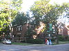
| 4 | Belmonte Flats | 4257-4259 S. Dr. Martin Luther King Jr. Drive, and 400-412 E. 43rd Street 41°49′0"N 87°36′17"W |
Grand Boulevard Grand Boulevard, Chicago Grand Boulevard, located on the South Side of Chicago, Illinois, is one of the well-defined Chicago Community Areas. The boulevard from which the community area takes its name now bears the name of Martin Luther King, Jr. Drive... |
|||
| 5 | Calumet Park Calumet Park Calumet Park is a 198 acre park in Chicago, Illinois. It provides access to Lake Michigan from the East Side neighborhood on the city's Southeast Side. The park contains approximately 0.9 miles of lake frontage from 95th Street to 102nd Street... |
9801 S. Avenue G 41°43′0"N 87°31′41"W |
East Side East Side, Chicago East Side is one of the 77 official community areas of Chicago, Illinois. It is located on the far south side of the city, between the Calumet River and the Illinois-Indiana state line, approximately south of Downtown Chicago... |
|||
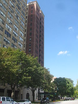
| 6 | Chicago Beach Hotel Chicago Beach Hotel The Chicago Beach Hotel was located in the Indian Village neighborhood of the Kenwood community area of Chicago, Illinois, on the property that currently houses Regents Park. The Hotel was built at East Hyde Park Boulevard and Cornell Avenue in 1890. It was one of many speculative hotels built... |
 |
5100-5110 S. Cornell Avenue 41°48′8"N 87°35′13"W |
Hyde Park Hyde Park, Chicago Hyde Park, located on the South Side of the City of Chicago, in Cook County, Illinois, United States and seven miles south of the Chicago Loop, is a Chicago neighborhood and one of 77 Chicago community areas. It is home to the University of Chicago, the Hyde Park Art Center, the Museum of Science... |
||
| 7 | Chicago Bee Building Chicago Bee Building The Chicago Bee was founded by the African American entrepreneur Anthony Overton in 1926 in what was one of Chicago's African American newspaper buildings. This building was Overton's affirmation of his confidence in the viability of the State Street Commercial district... |
3647-3655 S. State Street State Street (Chicago) State Street is a large south-north street in Chicago, Illinois, USA and its south suburbs. It begins on the Near North Side at North Avenue. For much of its course, it lies between Wabash Avenue on the east and Dearborn Street/Lafayette Avenue on the west... 41°49′41"N 87°37′34"W |
Douglas Douglas, Chicago Douglas, located on the South Side of Chicago, Illinois is one of 77 well-defined Chicago community areas. The neighborhood is named for Stephen A. Douglas, a famous Illinois politician, whose estate included a tract of land given to the federal government... |
|||
| 8 | Arthur H. Compton House Arthur H. Compton House The Arthur H. Compton House, located at 5637 South Woodlawn Avenue in Chicago, Illinois, was the residence of professor Arthur Compton from the late 1920s until 1945. Arthur Compton was a physicist who discovered the Compton Effect, proving that light has both a particle and a wave aspect. ... |
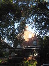 |
5637 S. Woodlawn Avenue 41°47′31"N 87°35′47"W |
Hyde Park Hyde Park, Chicago Hyde Park, located on the South Side of the City of Chicago, in Cook County, Illinois, United States and seven miles south of the Chicago Loop, is a Chicago neighborhood and one of 77 Chicago community areas. It is home to the University of Chicago, the Hyde Park Art Center, the Museum of Science... |
||
| 9 | Cornell Square | 1809 W. 50th Street 41°48′8"N 87°40′16"W |
New City New City, Chicago New City is one of Chicago's 77 official community areas, located on the southwest side of the city. The area is divided into It is a blend of predominantly Irish-Americans in Canaryville, Mexican-Americans in Back Of The Yards, and African-Americans south of 49th Street... |
|||
| 10 | Davis Square | Roughlu bounded by W. 44th Street, W, 45th Street, S. Marshfield Avenue and S. Hemitage Avenue 41°48′47"N 87°40′3"W |
New City New City, Chicago New City is one of Chicago's 77 official community areas, located on the southwest side of the city. The area is divided into It is a blend of predominantly Irish-Americans in Canaryville, Mexican-Americans in Back Of The Yards, and African-Americans south of 49th Street... |
|||
| 11 | Oscar Stanton De Priest House Oscar Stanton De Priest House The Oscar Stanton De Priest House is the current name of an eight-flat apartment building located at 4536-4538 South Dr. Martin Luther King, Jr., Drive in Chicago, Illinois, USA... |
4536-4538 S. Dr. Martin Luther King, Jr. Drive 41°48′42"N 87°37′5"W |
Grand Boulevard Grand Boulevard, Chicago Grand Boulevard, located on the South Side of Chicago, Illinois, is one of the well-defined Chicago Community Areas. The boulevard from which the community area takes its name now bears the name of Martin Luther King, Jr. Drive... |
|||
| 12 | Douglas Tomb State Memorial Stephen A. Douglas Tomb The Stephen A. Douglas Tomb and Memorial or Stephen Douglas Monument Park is located at 636 E. 35th Street in the Bronzeville neighborhood of Chicago, Illinois , near the site of the Union Army and prisoner of war Camp Douglas... |
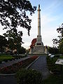 |
636 E. 35th Street 41°49′54"N 87°36′30"W |
Douglas Douglas, Chicago Douglas, located on the South Side of Chicago, Illinois is one of 77 well-defined Chicago community areas. The neighborhood is named for Stephen A. Douglas, a famous Illinois politician, whose estate included a tract of land given to the federal government... |
||
| 13 | East Park Towers | 5236-5252 S. Hyde Park Boulevard 41°47′59"N 87°35′4"W |
Hyde Park Hyde Park, Chicago Hyde Park, located on the South Side of the City of Chicago, in Cook County, Illinois, United States and seven miles south of the Chicago Loop, is a Chicago neighborhood and one of 77 Chicago community areas. It is home to the University of Chicago, the Hyde Park Art Center, the Museum of Science... |
|||
| 14 | Eighth Regiment Armory Eighth Regiment Armory (Chicago) The Eighth Regiment Armory, located in the Black Metropolis-Bronzeville District of Chicago, Illinois, was the first armory in the United States built for an African-American military regiment, known as the "Fighting 8th". The building later was used by a division of the Illinois National Guard,... |
3533 S. Giles Avenue 41°49′50"N 87°37′10"W |
Douglas Douglas, Chicago Douglas, located on the South Side of Chicago, Illinois is one of 77 well-defined Chicago community areas. The neighborhood is named for Stephen A. Douglas, a famous Illinois politician, whose estate included a tract of land given to the federal government... |
|||
| 15 | Site of First Self-Sustaining Nuclear Reaction | |
S. Ellis Avenue between E. 56th Street and 57th Street 41°47′33"N 87°36′4"W |
Hyde Park Hyde Park, Chicago Hyde Park, located on the South Side of the City of Chicago, in Cook County, Illinois, United States and seven miles south of the Chicago Loop, is a Chicago neighborhood and one of 77 Chicago community areas. It is home to the University of Chicago, the Hyde Park Art Center, the Museum of Science... |
||
| 16 | Flamingo-on-the-Lake Apartments Flamingo-on-the-Lake Apartments The Flamingo-on-the-Lake Apartments, also known as the Flamingo Apartment Hotel, is a building located at 5500-5520 S. Shore Drive along Lake Michigan in the Hyde Park neighborhood of Chicago, Illinois. It was designed in the Classical Revival style... |
 |
5500-5520 S. Shore Drive 41°47′41"N 87°34′51"W |
Hyde Park Hyde Park, Chicago Hyde Park, located on the South Side of the City of Chicago, in Cook County, Illinois, United States and seven miles south of the Chicago Loop, is a Chicago neighborhood and one of 77 Chicago community areas. It is home to the University of Chicago, the Hyde Park Art Center, the Museum of Science... |
||
| 17 | Four Nineteen Building | 419 E. 83rd Street 41°44′41"N 87°36′8"W |
Chatham Chatham, Chicago Chatham, located on the south side, is one of the 77 official community areas of South Side of the city of Chicago, Illinois. It includes the neighborhoods of Chatham and West Chesterfield... |
|||
| 18 | Fuller Park | 331 W. 45th Street 41°48′46"N 87°38′3"W |
Fuller Park Fuller Park, Chicago Fuller Park, located on the south side of Chicago, Illinois, is one of 77 officially designated Chicago community areas. It is named for Melville Weston Fuller, who was the Chief Justice of the United States between 1888 and 1910.... |
|||
| 19 | Garden Homes Historic District Garden Homes Historic District (Chicago, Illinois) The Garden Homes Historic District in Chicago, Illinois is a historic district that was listed on the National Register of Historic Places in 2005. In 2005, it included 88 contributing buildings.... |
Roughly bounded by S. Wabash Avenue, E. 87th Street, S. Indiana Avenue and E. 89th Street 41°44′11"N 87°37′18"W |
Chatham Chatham, Chicago Chatham, located on the south side, is one of the 77 official community areas of South Side of the city of Chicago, Illinois. It includes the neighborhoods of Chatham and West Chesterfield... |
|||
| 20 | Goldblatt Bros. Department Store | 4700 S. Ashland Avenue 41°48′30"N 87°39′55"W |
New City New City, Chicago New City is one of Chicago's 77 official community areas, located on the southwest side of the city. The area is divided into It is a blend of predominantly Irish-Americans in Canaryville, Mexican-Americans in Back Of The Yards, and African-Americans south of 49th Street... |
|||
| 21 | Grand Crossing Park | 7655 S. Ingleside Avenue 41°45′25"N 87°36′1"W |
Greater Grand Crossing | |||
| 22 | John W. Griffiths Mansion | 3806 S. Michigan Avenue Michigan Avenue (Chicago) Michigan Avenue is a major north-south street in Chicago which runs at 100 east south of the Chicago River and at 132 East north of the river from 12628 south to 950 north in the Chicago street address system... 41°49′32"N 87°37′26"W |
Douglas Douglas, Chicago Douglas, located on the South Side of Chicago, Illinois is one of 77 well-defined Chicago community areas. The neighborhood is named for Stephen A. Douglas, a famous Illinois politician, whose estate included a tract of land given to the federal government... |
|||
| 23 | Hamilton Park | 513 W. 72nd Street 41°45′42"N 87°38′14"W |
Englewood Englewood, Chicago Englewood, once known as "Junction Grove" , is one of the 77 official community areas of Chicago. At its height, over 97,000 people lived in its approximately 3 square miles , but the neighborhood's population has since dropped dramatically... |
|||
| 24 | Anton E. Hanson House | 7610 S. Ridgeland Avenue 41°45′31"N 87°34′57"W |
South Shore South Shore, Chicago South Shore is one of 77 well-defined community areas of the City of Chicago, Illinois in the United States. A predominately black neighborhood located along Chicago's southern lakefront, it is a relatively stable and gentrifying neighborhood... |
|||
| 25 | Isadore H. Heller House | _and_north_elevations_-_habs_ill,16-chig,48-1.jpg) |
5132 S. Woodlawn Avenue 41°48′5"N 87°35′35"W |
Hyde Park Hyde Park, Chicago Hyde Park, located on the South Side of the City of Chicago, in Cook County, Illinois, United States and seven miles south of the Chicago Loop, is a Chicago neighborhood and one of 77 Chicago community areas. It is home to the University of Chicago, the Hyde Park Art Center, the Museum of Science... |
||
| 26 | Charles Hitchcock Hall | 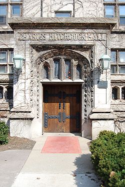 |
1009 E. 57th Street 41°47′28"N 87°36′3"W |
Hyde Park Hyde Park, Chicago Hyde Park, located on the South Side of the City of Chicago, in Cook County, Illinois, United States and seven miles south of the Chicago Loop, is a Chicago neighborhood and one of 77 Chicago community areas. It is home to the University of Chicago, the Hyde Park Art Center, the Museum of Science... |
||
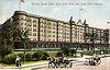
| 27 | Hotel Del Prado | 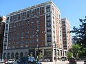 |
5307 S. Hyde Park Boulevard 41°47′58"N 87°35′2"W |
Hyde Park Hyde Park, Chicago Hyde Park, located on the South Side of the City of Chicago, in Cook County, Illinois, United States and seven miles south of the Chicago Loop, is a Chicago neighborhood and one of 77 Chicago community areas. It is home to the University of Chicago, the Hyde Park Art Center, the Museum of Science... |
||
| 28 | Hotel Windermere East | 1642 E. 56th Street 41°47′35"N 87°35′0"W |
Hyde Park Hyde Park, Chicago Hyde Park, located on the South Side of the City of Chicago, in Cook County, Illinois, United States and seven miles south of the Chicago Loop, is a Chicago neighborhood and one of 77 Chicago community areas. It is home to the University of Chicago, the Hyde Park Art Center, the Museum of Science... |
|||
| 29 | Hyde Park-Kenwood Historic District | Roughly bounded by E. 47th Street and E. 59th Street, S. Cottage Grove Avenue and S. Lake Park Avenue; also 821-829 and 816-826 E. 49th Street; also 825-833 and 837-849 E. 52nd Street 41°47′53"N 87°35′51"W |
Hyde Park Hyde Park, Chicago Hyde Park, located on the South Side of the City of Chicago, in Cook County, Illinois, United States and seven miles south of the Chicago Loop, is a Chicago neighborhood and one of 77 Chicago community areas. It is home to the University of Chicago, the Hyde Park Art Center, the Museum of Science... and Kenwood Kenwood, Chicago Kenwood, located on the South Side of the City of Chicago, Illinois, is one of the 77 well-defined Chicago community areas.Kenwood was part of Hyde Park Township, which was annexed by the City of Chicago in 1889.... |
Second and third sets of boundaries represent boundary increases of and respectively | ||
| 30 | Illinois Institute of Technology Academic Campus Illinois Institute of Technology Academic Campus Illinois Institute of Technology Academic Campus or IIT Main Campus is one of five campuses of the Illinois Institute of Technology. It is located in the Douglas community area and has an official address of 3300 South Federal Street and is roughly bounded by 31st Street, State Street, 35th Street... |
 |
Roughly bounded by 31st Street, State Street State Street (Chicago) State Street is a large south-north street in Chicago, Illinois, USA and its south suburbs. It begins on the Near North Side at North Avenue. For much of its course, it lies between Wabash Avenue on the east and Dearborn Street/Lafayette Avenue on the west... , 35th Street and the Dan Ryan Expressway Dan Ryan Expressway The Dan Ryan is an expressway in the city of Chicago that runs from the Circle Interchange with I-290 near downtown Chicago through the South Side of the city. It is designated as both Interstate 94 and Interstate 90 south to 66th Street, a distance of... 41°50′6"N 87°37′42"W |
Douglas Douglas, Chicago Douglas, located on the South Side of Chicago, Illinois is one of 77 well-defined Chicago community areas. The neighborhood is named for Stephen A. Douglas, a famous Illinois politician, whose estate included a tract of land given to the federal government... |
||
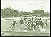
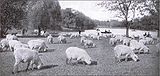
| 31 | Jackson Park Historic Landscape District and Midway Plaisance | 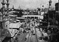 |
Jackson Jackson Park (Chicago) Jackson Park is a 500 acre park on Chicago's South Side, located at 6401 South Stony Island Avenue in the Woodlawn community area. It extends into the South Shore and Hyde Park community areas, bordering Lake Michigan and several South Side neighborhoods... and Washington Washington Park (Chicago park) On December 6, 1879, former U.S. President Ulysses Grant took part in a tree planting ceremony in the park. A memorial boulder with a plaque commemorated the event. In the 1920s black semiprofessional baseball teams played at Washington Park... Parks and Midway Plaisance Midway Plaisance The Midway Plaisance, also known locally as the Midway, is a park on the South Side of the city of Chicago, Illinois. It is one mile long by 220 yards wide and extends along 59th and 60th streets, joining Washington Park at its east end and Jackson Park at its west end. It divides the Hyde Park... roadway 41°46′48"N 87°34′38"W |
Hyde Park Hyde Park, Chicago Hyde Park, located on the South Side of the City of Chicago, in Cook County, Illinois, United States and seven miles south of the Chicago Loop, is a Chicago neighborhood and one of 77 Chicago community areas. It is home to the University of Chicago, the Hyde Park Art Center, the Museum of Science... , Washington Park and Woodlawn Woodlawn, Chicago Woodlawn, located in the South Side of the City of Chicago, Illinois, USA, is one of 77 well defined Chicago community areas. It is bounded by Lake Michigan to the east, 60th Street to the north, Martin Luther King Drive to the west, and, mostly, 67th Street to the south... |
||
| 32 | Jackson Shore Apartments | 5490 S. Shore Drive 41°47′43.80"N 87°34′51.10"W |
Hyde Park Hyde Park, Chicago Hyde Park, located on the South Side of the City of Chicago, in Cook County, Illinois, United States and seven miles south of the Chicago Loop, is a Chicago neighborhood and one of 77 Chicago community areas. It is home to the University of Chicago, the Hyde Park Art Center, the Museum of Science... |
|||
| 33 | Jeffery-Cyril Historic District | 7146-7148, 7128-7138 S. Cyril Avenue, 7144-7148, 7147 and 7130 S. Jeffrey Boulevard, and 1966-1974 E. 71st Place 41°45′53"N 87°34′36"W |
South Shore South Shore, Chicago South Shore is one of 77 well-defined community areas of the City of Chicago, Illinois in the United States. A predominately black neighborhood located along Chicago's southern lakefront, it is a relatively stable and gentrifying neighborhood... |
|||
| 34 | Kehilath Anshe Ma'ariv Synagogue Pilgrim Baptist Church Pilgrim Baptist Church is an historic church located on the south side of Chicago, Illinois, USA. The landmarked building was originally constructed for a synagogue, K.A.M. Isaiah Israel Temple. The church is notable both as an architectural landmark and for the cultural contributions by the... |
 |
3301 S. Indiana Avenue 41°50′4"N 87°37′20"W |
Douglas Douglas, Chicago Douglas, located on the South Side of Chicago, Illinois is one of 77 well-defined Chicago community areas. The neighborhood is named for Stephen A. Douglas, a famous Illinois politician, whose estate included a tract of land given to the federal government... |
||
| 35 | Sydney Kent House Sydney Kent House The Kent House, also known as Sydney Kent House or St. James Convent, is a Queen Anne style house located at 2944 South Michigan Avenue in Chicago, Illinois, United States. The house was built in 1883 by Burnham & Root for Sidney A. Kent... |
2944 S. Michigan Avenue Michigan Avenue (Chicago) Michigan Avenue is a major north-south street in Chicago which runs at 100 east south of the Chicago River and at 132 East north of the river from 12628 south to 950 north in the Chicago street address system... 41°50′26"N 87°37′27"W |
Douglas Douglas, Chicago Douglas, located on the South Side of Chicago, Illinois is one of 77 well-defined Chicago community areas. The neighborhood is named for Stephen A. Douglas, a famous Illinois politician, whose estate included a tract of land given to the federal government... |
|||
| 36 | Kenwood Evangelical Church | 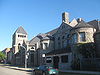 |
4600-4608 S. Greenwood Avenue 41°48′41"N 87°36′0"W |
Kenwood Kenwood, Chicago Kenwood, located on the South Side of the City of Chicago, Illinois, is one of the 77 well-defined Chicago community areas.Kenwood was part of Hyde Park Township, which was annexed by the City of Chicago in 1889.... |
||
| 37 | Lake-Side Terrace Apartments | 7425-7427 S. South Shore Drive 41°45′44"N 87°33′25"W |
South Shore South Shore, Chicago South Shore is one of 77 well-defined community areas of the City of Chicago, Illinois in the United States. A predominately black neighborhood located along Chicago's southern lakefront, it is a relatively stable and gentrifying neighborhood... |
|||
| 38 | Frank R. Lillie House Frank R. Lillie House The Frank R. Lillie House is the former home of American embryologist Frank R. Lillie. Located at 5801 South Kenwood Avenue in Hyde Park community area of Chicago, Illinois, the building was designated a National Historic Landmark on May 11, 1976.-Note:... |
 |
5801 S. Kenwood Avenue 41°47′22"N 87°35′34"W |
Hyde Park Hyde Park, Chicago Hyde Park, located on the South Side of the City of Chicago, in Cook County, Illinois, United States and seven miles south of the Chicago Loop, is a Chicago neighborhood and one of 77 Chicago community areas. It is home to the University of Chicago, the Hyde Park Art Center, the Museum of Science... |
||
| 39 | Mayfair Apartments | 1650-1666 E. 56th Street 41°47′43"N 87°35′3"W |
Hyde Park Hyde Park, Chicago Hyde Park, located on the South Side of the City of Chicago, in Cook County, Illinois, United States and seven miles south of the Chicago Loop, is a Chicago neighborhood and one of 77 Chicago community areas. It is home to the University of Chicago, the Hyde Park Art Center, the Museum of Science... |
|||
| 40 | Allan Miller House Allan Miller House The Allan Miller House is a prairie style house in the South Shore neighborhood of Chicago, United States. Located along Paxton Avenue, the home is the only surviving example of Frank Lloyd Wright colleague John S. Van Bergen's work found in Chicago. The house is cast in prairie style and was... |
7121 S. Paxton Avenue 41°45′57"N 87°34′16"W |
South Shore South Shore, Chicago South Shore is one of 77 well-defined community areas of the City of Chicago, Illinois in the United States. A predominately black neighborhood located along Chicago's southern lakefront, it is a relatively stable and gentrifying neighborhood... |
|||
| 41 | Robert A. Millikan House Robert A. Millikan House The Robert A. Millikan House is the former home of American physicist Robert A. Millikan. Located at 5605 South Woodlawn Avenue in Hyde Park community area of Chicago, Illinois, the three-story brick building earned National Historic Landmark status on May 11, 1976.-Note:... |
 |
5605 S. Woodlawn Avenue 41°47′34"N 87°35′47"W |
Hyde Park Hyde Park, Chicago Hyde Park, located on the South Side of the City of Chicago, in Cook County, Illinois, United States and seven miles south of the Chicago Loop, is a Chicago neighborhood and one of 77 Chicago community areas. It is home to the University of Chicago, the Hyde Park Art Center, the Museum of Science... |
||
| 42 | The Narragansett | 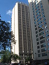 |
1640 E. 50th Street 41°48′16"N 87°35′5"W |
Kenwood Kenwood, Chicago Kenwood, located on the South Side of the City of Chicago, Illinois, is one of the 77 well-defined Chicago community areas.Kenwood was part of Hyde Park Township, which was annexed by the City of Chicago in 1889.... |
||
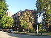
| 43 | Old Stone Gate of Chicago Union Stockyards | 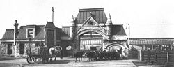 |
W. Exchange Avenue & S. Peoria Street 41°49′7"N 87°38′54"W |
New City New City, Chicago New City is one of Chicago's 77 official community areas, located on the southwest side of the city. The area is divided into It is a blend of predominantly Irish-Americans in Canaryville, Mexican-Americans in Back Of The Yards, and African-Americans south of 49th Street... |
||
| 44 | Overton Hygienic Building Overton Hygienic Building The Overton Hygienic Building is a Chicago Landmark and part of the Black Metropolis-Bronzeville District in the Douglas community area of Chicago, Illinois. It is located at 3619-3627 State Street.... |
3619-3627 S. State Street State Street (Chicago) State Street is a large south-north street in Chicago, Illinois, USA and its south suburbs. It begins on the Near North Side at North Avenue. For much of its course, it lies between Wabash Avenue on the east and Dearborn Street/Lafayette Avenue on the west... 41°49′41"N 87°37′34"W |
Douglas Douglas, Chicago Douglas, located on the South Side of Chicago, Illinois is one of 77 well-defined Chicago community areas. The neighborhood is named for Stephen A. Douglas, a famous Illinois politician, whose estate included a tract of land given to the federal government... |
|||
| 45 | Palmer Park | 201 E. 111th Street 41°41′33.35"N 87°37′5.62"W |
Roseland Roseland, Chicago Roseland, located on the far south side of the city, is one of the 77 official community areas of Chicago, Illinois. It includes the neighborhoods of Fernwood, Princeton Park, Lilydale, West Chesterfield, Rosemoor, Sheldon Heights and West Roseland... |
|||
| 46 | Poinsettia Apartments | 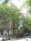 |
5528 S. Hyde Park Boulevard 41°47′39"N 87°35′3"W |
Hyde Park Hyde Park, Chicago Hyde Park, located on the South Side of the City of Chicago, in Cook County, Illinois, United States and seven miles south of the Chicago Loop, is a Chicago neighborhood and one of 77 Chicago community areas. It is home to the University of Chicago, the Hyde Park Art Center, the Museum of Science... |
||
| 47 | Promontory Apartments | 5530-5532 S. Shore Drive 41°47′39"N 87°34′51"W |
Hyde Park Hyde Park, Chicago Hyde Park, located on the South Side of the City of Chicago, in Cook County, Illinois, United States and seven miles south of the Chicago Loop, is a Chicago neighborhood and one of 77 Chicago community areas. It is home to the University of Chicago, the Hyde Park Art Center, the Museum of Science... |
|||
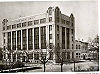
| 48 | Pullman Historic District Pullman District The Pullman District, as it has been designated on the list of Chicago Landmarks, or Pullman Historic District, as it has been designated on the National Register of Historic Places, was the first model, planned industrial community in the United States... |
.jpg) |
Bounded by E. 103rd Street, C.S.S. and S.B. Railroad spur tracks, E. 115th Street and S. Cottage Grove Avenue 41°41′50"N 87°36′34"W |
Pullman Pullman, Chicago Pullman, one of Chicago's 77 community areas, is a neighborhood located on the city's South Side. Twelve miles from the Chicago Loop, Pullman is situated adjacent Lake Calumet.... |
||
| 49 | Ridge Historic District | Roughly bounded by RR tracks, W. 87th Street, S. Prospect Avenue, S. Homewood Avenue, W. 115th Street, S. Lothair Avenue, S. Hamilton Avenue, and S. Western Avenue Western Avenue (Chicago) Western Avenue is the longest continuous street within the city of Chicago at in length. Western Avenue extends south as a continuous road to the Dixie Highway at Sibley Boulevard in Dixmoor, giving the road a total length of . However, Western Avenue extends intermittently through the... 41°42′36"N 87°40′13"W |
Beverly Beverly, Chicago Beverly is one of the 77 official community areas of Chicago, Illinois. It is located on the South Side on the southwestern edge of the city. Beverly Hills was built by English engineers as an exclusive streetcar suburb and the homes and large lots reflect this historic distinction... and Morgan Park Morgan Park, Chicago Morgan Park, located on the far south side of the city of Chicago, Illinois, United States, is one of the city's 77 official community areas.-Morgan Park:... |
|||
| 50 | Frederick C. Robie House | 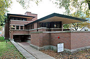 |
5757 S. Woodlawn Avenue 41°47′23"N 87°35′45"W |
Hyde Park Hyde Park, Chicago Hyde Park, located on the South Side of the City of Chicago, in Cook County, Illinois, United States and seven miles south of the Chicago Loop, is a Chicago neighborhood and one of 77 Chicago community areas. It is home to the University of Chicago, the Hyde Park Art Center, the Museum of Science... |
||
| 51 | Martin Roche-John Tait House | 3614 S. Dr. Martin Luther King Jr. Drive 41°49′46"N 87°37′4"W |
Douglas Douglas, Chicago Douglas, located on the South Side of Chicago, Illinois is one of 77 well-defined Chicago community areas. The neighborhood is named for Stephen A. Douglas, a famous Illinois politician, whose estate included a tract of land given to the federal government... |
|||
| 52 | Robert Roloson Houses | 3213-3219 S. Calumet Avenue 41°50′8"N 87°37′4"W |
Douglas Douglas, Chicago Douglas, located on the South Side of Chicago, Illinois is one of 77 well-defined Chicago community areas. The neighborhood is named for Stephen A. Douglas, a famous Illinois politician, whose estate included a tract of land given to the federal government... |
|||
| 53 | Room 405, George Herbert Jones Laboratory, The University of Chicago George Herbert Jones Laboratory The George Herbert Jones Laboratory, at 5747 S. Ellis Avenue, Chicago, Illinois, is a facility building of the University of Chicago. Room 405 of the building was named a National Historic Landmark in May 1967.... |
S. Ellis Avenue between E. 57th Street and 58th Street 41°47′25"N 87°36′4"W |
Hyde Park Hyde Park, Chicago Hyde Park, located on the South Side of the City of Chicago, in Cook County, Illinois, United States and seven miles south of the Chicago Loop, is a Chicago neighborhood and one of 77 Chicago community areas. It is home to the University of Chicago, the Hyde Park Art Center, the Museum of Science... |
|||
| 54 | Rosenwald Apartment Building | 4618 - 4646 S. Michigan Avenue Michigan Avenue (Chicago) Michigan Avenue is a major north-south street in Chicago which runs at 100 east south of the Chicago River and at 132 East north of the river from 12628 south to 950 north in the Chicago street address system... 41°48′37"N 87°37′26"W |
Grand Boulevard Grand Boulevard, Chicago Grand Boulevard, located on the South Side of Chicago, Illinois, is one of the well-defined Chicago Community Areas. The boulevard from which the community area takes its name now bears the name of Martin Luther King, Jr. Drive... |
|||
| 55 | S.R. Crown Hall S.R. Crown Hall S. R. Crown Hall, designed by the German-born Modernist architect Ludwig Mies van der Rohe, is the home of the College of Architecture at the Illinois Institute of Technology in Chicago, Illinois.-History:... |
3360 S. State Street State Street (Chicago) State Street is a large south-north street in Chicago, Illinois, USA and its south suburbs. It begins on the Near North Side at North Avenue. For much of its course, it lies between Wabash Avenue on the east and Dearborn Street/Lafayette Avenue on the west... 41°50′0.9"N 87°37′36.3"W |
Douglas Douglas, Chicago Douglas, located on the South Side of Chicago, Illinois is one of 77 well-defined Chicago community areas. The neighborhood is named for Stephen A. Douglas, a famous Illinois politician, whose estate included a tract of land given to the federal government... |
|||
| 56 | St. Thomas Church and Convent | 5472 S. Kimbark Avenue 41°47′44"N 87°35′43"W |
Hyde Park Hyde Park, Chicago Hyde Park, located on the South Side of the City of Chicago, in Cook County, Illinois, United States and seven miles south of the Chicago Loop, is a Chicago neighborhood and one of 77 Chicago community areas. It is home to the University of Chicago, the Hyde Park Art Center, the Museum of Science... |
|||
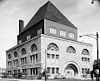
| 57 | Schulze Baking Company Plant Schulze Baking Company Plant Schulze Baking Company Plant is a factory building located on the South Side of Chicago, Illinois, United States. It is located at 40 East Garfield Boulevard in the Washington Park community area in Cook County. Built in 1914, the building was listed on the National Register of Historic Places on... |
 |
40 E. Garfield Boulevard 41°47′44"N 87°37′29"W |
Washington Park | ||
| 58 | Sherman Park Sherman Park Sherman Park is a sixty-acre park in the New City neighborhood of Chicago. It was designed by Daniel Burnham, John Charles Olmsted, and Frederick Law Olmsted, Jr., and opened in 1905. It takes its name from John B... |
Bounded by W. 52nd Street, S. Racine Avenue, W. Garfield Boulevard, and S. Loomis Street 41°47′48"N 87°39′18"W |
New City New City, Chicago New City is one of Chicago's 77 official community areas, located on the southwest side of the city. The area is divided into It is a blend of predominantly Irish-Americans in Canaryville, Mexican-Americans in Back Of The Yards, and African-Americans south of 49th Street... |
|||
| 59 | Shoreland Hotel Shoreland Hotel The Shoreland is a former hotel in the Hyde Park neighborhood of Chicago, Illinois. It was added to the United States National Register of Historic Places in 1986... |
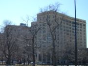 |
5450-5484 S. Shore Drive 41°47′45"N 87°34′52"W |
Hyde Park Hyde Park, Chicago Hyde Park, located on the South Side of the City of Chicago, in Cook County, Illinois, United States and seven miles south of the Chicago Loop, is a Chicago neighborhood and one of 77 Chicago community areas. It is home to the University of Chicago, the Hyde Park Art Center, the Museum of Science... |
||
| 60 | South Park Manor Historic District | Roughly bounded by S. Dr. Martin Luther King Jr. Drive., S. State Street State Street (Chicago) State Street is a large south-north street in Chicago, Illinois, USA and its south suburbs. It begins on the Near North Side at North Avenue. For much of its course, it lies between Wabash Avenue on the east and Dearborn Street/Lafayette Avenue on the west... , E. 75th Street and E. 79th Street 41°45′25"N 87°37′9"W |
Greater Grand Crossing | |||
| 61 | South Shore Beach Apartments | 7321 S. South Shore Drive 41°45′50"N 87°33′34"W |
South Shore South Shore, Chicago South Shore is one of 77 well-defined community areas of the City of Chicago, Illinois in the United States. A predominately black neighborhood located along Chicago's southern lakefront, it is a relatively stable and gentrifying neighborhood... |
|||
| 62 | South Shore Bungalow Historic District | Bounded roughly by S. Crandon Avenue on the East, E. 78th Street on the South, S. Clyde Avenue on the West, E. 75th Street on the North 41°45′12.61"N 87°34′7.18"W |
South Shore South Shore, Chicago South Shore is one of 77 well-defined community areas of the City of Chicago, Illinois in the United States. A predominately black neighborhood located along Chicago's southern lakefront, it is a relatively stable and gentrifying neighborhood... |
|||
| 63 | South Shore Country Club | 7059 S. South Shore Drive 41°46′11"N 87°33′46"W |
South Shore South Shore, Chicago South Shore is one of 77 well-defined community areas of the City of Chicago, Illinois in the United States. A predominately black neighborhood located along Chicago's southern lakefront, it is a relatively stable and gentrifying neighborhood... |
|||
| 64 | Spiegel Office Building | 1038 W. 35th Street 41°49′50"N 87°39′9"W |
Bridgeport Bridgeport, Chicago Bridgeport, one of 77 community areas of Chicago, is a neighborhood located on the city's South Side. It is bounded, generally, on the west and north by the Chicago River, on the east by Canal Street, and on the south by Pershing Road.-History:... |
|||
| 65 | Sutherland Hotel | 4659 S. Drexel Blvd. 41°48′35"N 87°36′12"W |
Kenwood Kenwood, Chicago Kenwood, located on the South Side of the City of Chicago, Illinois, is one of the 77 well-defined Chicago community areas.Kenwood was part of Hyde Park Township, which was annexed by the City of Chicago in 1889.... |
|||
| 66 | Swift House | 4500 S. Michigan Avenue Michigan Avenue (Chicago) Michigan Avenue is a major north-south street in Chicago which runs at 100 east south of the Chicago River and at 132 East north of the river from 12628 south to 950 north in the Chicago street address system... 41°48′47"N 87°37′24"W |
Grand Boulevard Grand Boulevard, Chicago Grand Boulevard, located on the South Side of Chicago, Illinois, is one of the well-defined Chicago Community Areas. The boulevard from which the community area takes its name now bears the name of Martin Luther King, Jr. Drive... |
|||
| 67 | Lorado Taft Midway Studios Lorado Taft Midway Studios The Lorado Taft Midway Studios consist of a converted and relocated barn that became the art studio of one of the early 20th century's most important sculptors, Lorado Taft. It is located in the Woodlawn community area of Chicago, Illinois and is now owned by the University of Chicago. It was... |
.jpg) |
6016 S. Ingleside Avenue 41°47′8"N 87°36′13"W |
Woodlawn Woodlawn, Chicago Woodlawn, located in the South Side of the City of Chicago, Illinois, USA, is one of 77 well defined Chicago community areas. It is bounded by Lake Michigan to the east, 60th Street to the north, Martin Luther King Drive to the west, and, mostly, 67th Street to the south... |
||
| 68 | Trumbull Park | 2400 E. 105th Street 41°42′23"N 87°33′52"W |
South Deering South Deering, Chicago South Deering, one of the 77 official community areas of the City of Chicago, Illinois, is located on the far south side. It was a very industrial neighborhood, consisting of a small group of homes in the northeast corner and Lake Calumet taking up most of the remainder. It exists in the 10th Ward,... |
|||
| 69 |  |
Jackson Park Jackson Park (Chicago) Jackson Park is a 500 acre park on Chicago's South Side, located at 6401 South Stony Island Avenue in the Woodlawn community area. It extends into the South Shore and Hyde Park community areas, bordering Lake Michigan and several South Side neighborhoods... 41°47′31"N 87°34′55"W |
Hyde Park Hyde Park, Chicago Hyde Park, located on the South Side of the City of Chicago, in Cook County, Illinois, United States and seven miles south of the Chicago Loop, is a Chicago neighborhood and one of 77 Chicago community areas. It is home to the University of Chicago, the Hyde Park Art Center, the Museum of Science... |
|||
| 70 | Unity Hall | 3140 S. Indiana Avenue 41°50′16"N 87°37′21"W |
Douglas Douglas, Chicago Douglas, located on the South Side of Chicago, Illinois is one of 77 well-defined Chicago community areas. The neighborhood is named for Stephen A. Douglas, a famous Illinois politician, whose estate included a tract of land given to the federal government... |
|||
| 71 | University Apartments | 1401 and 1451 E. 55th Street;1401 and 1450 E. 55th Place 41°47′50"N 87°35′27"W |
Hyde Park Hyde Park, Chicago Hyde Park, located on the South Side of the City of Chicago, in Cook County, Illinois, United States and seven miles south of the Chicago Loop, is a Chicago neighborhood and one of 77 Chicago community areas. It is home to the University of Chicago, the Hyde Park Art Center, the Museum of Science... |
|||
| 72 | Victory Sculpture Victory Monument (Chicago) The Victory Monument, created by sculptor Leonard Crunelle, was built to honor the Eighth Regiment of the Illinois National Guard, an African-American unit that served in France during World War I. It is located in the Black Metropolis-Bronzeville District in the Douglas community area of Chicago,... |
E. 35th Street at S. Dr. Martin Luther King Jr. Drive 41°49′52"N 87°37′3"W |
Douglas Douglas, Chicago Douglas, located on the South Side of Chicago, Illinois is one of 77 well-defined Chicago community areas. The neighborhood is named for Stephen A. Douglas, a famous Illinois politician, whose estate included a tract of land given to the federal government... |
|||
| 73 | Wabash Avenue YMCA Wabash Avenue YMCA The Wabash Avenue YMCA is a Chicago Landmark located within the Chicago Landmark Black Metropolis-Bronzeville Historic District in the Douglas community area of Chicago, Illinois. This YMCA facility served as an important social center within the Black Metropolis area, and it also provided housing... |
3763 S. Wabash Avenue 41°49′33"N 87°37′29"W |
Douglas Douglas, Chicago Douglas, located on the South Side of Chicago, Illinois is one of 77 well-defined Chicago community areas. The neighborhood is named for Stephen A. Douglas, a famous Illinois politician, whose estate included a tract of land given to the federal government... |
|||
| 74 | Washington Park Washington Park (Chicago park) On December 6, 1879, former U.S. President Ulysses Grant took part in a tree planting ceremony in the park. A memorial boulder with a plaque commemorated the event. In the 1920s black semiprofessional baseball teams played at Washington Park... |
 |
5531 S. Dr. Martin Luther King Jr. Drive 41°47′45"N 87°36′40"W |
Washington Park | ||
| 75 | Ida B. Wells-Barnett House Ida B. Wells-Barnett House The Ida B. Wells - Barnett House was the residence of civil rights advocate Ida B. Wells, and her husband Ferdinand Lee Barnett from 1919 to 1930. It is located at 3624 S. Dr. Martin Luther King Jr. Memorial Drive in the Douglas community area of Chicago, Illinois. It was designated a Chicago... |
.jpg) |
3624 S. Martin Luther King Jr. Drive 41°49′47"N 87°37′3"W |
Douglas Douglas, Chicago Douglas, located on the South Side of Chicago, Illinois is one of 77 well-defined Chicago community areas. The neighborhood is named for Stephen A. Douglas, a famous Illinois politician, whose estate included a tract of land given to the federal government... |
||
| 76 | West Chatham Bungalow Historic District | Bounded roughly by S. Perry Ave (E), 82nd St. (S), S. Stewart Ave. (W), and W. 79th St. (N) 41°44′53.43"N 87°37′50.08"W |
Chatham Chatham, Chicago Chatham, located on the south side, is one of the 77 official community areas of South Side of the city of Chicago, Illinois. It includes the neighborhoods of Chatham and West Chesterfield... |
|||
| 77 | Dr. Daniel Hale Williams House | 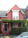 |
445 E. 42nd Street 41°49′7"N 87°36′55"W |
Grand Boulevard Grand Boulevard, Chicago Grand Boulevard, located on the South Side of Chicago, Illinois, is one of the well-defined Chicago Community Areas. The boulevard from which the community area takes its name now bears the name of Martin Luther King, Jr. Drive... |
||
| 78 | The Yale | 6565 S. Yale Avenue 41°46′28"N 87°37′53"W |
Englewood Englewood, Chicago Englewood, once known as "Junction Grove" , is one of the 77 official community areas of Chicago. At its height, over 97,000 people lived in its approximately 3 square miles , but the neighborhood's population has since dropped dramatically... |
|||
Key
| NRHP-listed | |
| ∞ | NRHP-listed Historic district Historic district A historic district or heritage district is a section of a city which contains older buildings considered valuable for historical or architectural reasons. In some countries, historic districts receive legal protection from development.... |
| * | National Historic Landmark National Historic Landmark A National Historic Landmark is a building, site, structure, object, or district, that is officially recognized by the United States government for its historical significance... and NRHP-listed |
| ∞ | National Historic Landmark National Historic Landmark A National Historic Landmark is a building, site, structure, object, or district, that is officially recognized by the United States government for its historical significance... and NRHP-listed Historic district Historic district A historic district or heritage district is a section of a city which contains older buildings considered valuable for historical or architectural reasons. In some countries, historic districts receive legal protection from development.... |
See also
- List of Chicago Landmarks
- List of Registered Historic Places in Illinois
- List of National Historic Landmarks in Illinois
- National Register of Historic Places listings in Central ChicagoNational Register of Historic Places listings in Central ChicagoCurrently there are 114 National Register of Historic Places listings in Central Chicago, out of 326 listings in the City of Chicago. Central Chicago includes 3 of the 77 well-defined community areas of Chicago: the historic business and cultural center of Chicago, the Loop, as well as the Near...
- National Register of Historic Places listings in North Side ChicagoNational Register of Historic Places listings in North Side ChicagoThere are 81 sites in the National Register of Historic Places listings in North Side Chicago, out of 326 listings in the City of Chicago. The North Side is defined for this article as the area west of Lake Michigan, north of North Avenue and east of the Chicago River plus the area north of...
- National Register of Historic Places listings in West Side ChicagoNational Register of Historic Places listings in West Side ChicagoThere are 54 sites in the National Register of Historic Places listings in West Side Chicago, out of 326 listings in the City of Chicago. The West Side is defined for this article as the area north of the Chicago Sanitary and Ship Canal, south of Fullerton Avenue, west of the Chicago River and east...
- National Register of Historic Places listings in Central Chicago
External links
- Chicago Listing on the National Register of Historic Places, February 10, 2009, City of Chicago, Richard M. Daley, Mayor.
- Cook County, Illinois listings at NRHP.COM, a private site repackaging government NRHP data
- National Register Information System, National Park Service.