

National Register of Historic Places listings in Oconee County, South Carolina
Encyclopedia
This is intended to be a complete list of the properties and districts on the National Register of Historic Places
National Register of Historic Places
The National Register of Historic Places is the United States government's official list of districts, sites, buildings, structures, and objects deemed worthy of preservation...
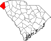
in Oconee County, South Carolina
South Carolina
South Carolina is a state in the Deep South of the United States that borders Georgia to the south, North Carolina to the north, and the Atlantic Ocean to the east. Originally part of the Province of Carolina, the Province of South Carolina was one of the 13 colonies that declared independence...
, United States
United States
The United States of America is a federal constitutional republic comprising fifty states and a federal district...
. The locations of National Register properties and districts for which the latitude and longitude coordinates are included below, may be seen on a map.
There are 19 properties and districts listed on the National Register in the county. Another 2 properties were once listed but have been removed.
Current listings
|}Former listings
| Landmark name | Image | Dates | Location | City or Town | Summary | |
|---|---|---|---|---|---|---|
| 1 | Oconee County Jail Oconee County Jail The old Oconee County Jail is a former jail that was located at Short Street in Walhalla, South Carolina in Oconee County. The jail was located on the grounds of the current Oconee County Courthouse. It was named to the National Register of Historic Places on November 14, 1982 along with the Oconee... |
(delisted) | Walhalla Walhalla, South Carolina Walhalla is a mountain city in Oconee County, South Carolina, United States. It is located from Clemson University in Clemson, South Carolina and is also located in the Appalachian Mountains of South Carolina. The population was 3,801 at the 2000 census. It is the county seat of Oconee County... |
It was demolished. | ||
| 2 | Prather's Bridge | .jpg) |
(delisted) | 34°38′50"N 83°16′46"W | It was burned. |
See also
- List of National Historic Landmarks in South Carolina
- National Register of Historic Places listings in South Carolina