

National Register of Historic Places listings in New Bedford, Massachusetts
Encyclopedia
List of Registered Historic Places
in New Bedford
, Massachusetts
, which has been transferred from and is an integral part of List of Registered Historic Places in Bristol County, Massachusetts
National Register of Historic Places
The National Register of Historic Places is the United States government's official list of districts, sites, buildings, structures, and objects deemed worthy of preservation...
in New Bedford
New Bedford
-Places:*New Bedford, Illinois*New Bedford, Massachusetts, the most populous New Bedford**New Bedford Whaling National Historical Park*New Bedford, New Jersey *New Bedford, Ohio*New Bedford, Pennsylvania...
, Massachusetts
Massachusetts
The Commonwealth of Massachusetts is a state in the New England region of the northeastern United States of America. It is bordered by Rhode Island and Connecticut to the south, New York to the west, and Vermont and New Hampshire to the north; at its east lies the Atlantic Ocean. As of the 2010...
, which has been transferred from and is an integral part of List of Registered Historic Places in Bristol County, Massachusetts
| Landmark name | Image | Date listed | Location | Summary | |
|---|---|---|---|---|---|
| 1 | Acushnet Heights Historic District Acushnet Heights Historic District Acushnet Heights Historic District is a historic district roughly bounded by Summer, Weld, Purchase, Pope, County, and Robeson Street in New Bedford, Massachusetts.The district was added to the National Historic Register in 1989.... |
Roughly bounded by Summer, Weld, Purchase, Pope, County, and Robeson 41°38′52"N 70°55′53"W |
|||
| 2 | Butler Flats Light Butler Flats Light Butler Flats Light, New Bedford, Massachusetts is a sparkplug lighthouse located in the New Bedford outer harbor, at the mouth of the Acushnet River. It is currently operated by the City of New Bedford... |
 |
New Bedford Channel 41°36′7"N 70°53′54"W |
||
| 3 | Buttonwood Park Historic District Buttonwood Park Historic District Buttonwood Park Historic District is a historic district on Kempton Street, Rockdale Avenue, Hawthorne Street and Brownell Avenue in New Bedford, Massachusetts.The district was added to the National Register of Historic Places in 2000.... |
Kempton St., Rockdale Ave., Hawthorne St., and Brownell Ave. 41°37′55"N 70°57′7"W |
|||
| 4 | Sgt. William H. Carney House Sgt. William H. Carney House Sgt. William H. Carney House is a historic house at 128 Mill Street in New Bedford, Massachusetts.The house was built in 1850 and added to the National Historic Register in 1975.... |
128 Mill St. 41°38′15"N 70°55′59"W |
|||
| 5 | Central New Bedford Historic District Central New Bedford Historic District The Central New Bedford Historic District is one of nine historic districts in New Bedford, Massachusetts, United States. It is a rectangular area bounded by Acushnet Avenue and the older New Bedford Historic District on the east, School Street to the south, Middle Street on the north and 6th... |
 |
Roughly bounded by Acushnet Ave. and School, Middle, and 6th Sts. 41°38′6"N 70°55′39"W |
||
| 6 | County Street Historic District County Street Historic District County Street Historic District is a historic district roughly bounded by Acushnet, Page, Middle, and Bedford streets in New Bedford, Massachusetts, USA.The district was added to the National Register of Historic Places in 1976.... |
Roughly bounded by Acushnet, Page, Middle, and Bedford Sts. (both sides) 41°37′55"N 70°55′55"W |
|||
| 7 | Dawson Building Dawson Building Dawson Building is a historic building at 1851 Purchase Street in New Bedford, Massachusetts.The building was constructed in 1896 and added to the National Historic Register in 1982.... |
1851 Purchase St. 41°39′0"N 70°55′48"W |
|||
| 8 | Thomas Donaghy School Thomas Donaghy School Thomas Donaghy School is a historic school in New Bedford, Massachusetts.The school was built in 1905 and added to the National Historic Register in 1989.... |
68 South St. 41°37′33"N 70°55′25"W |
|||
| 9 | ERNESTINA (schooner) Effie M. Morrissey The Effie M. Morrissey was a schooner skippered by Robert Bartlett that made many scientific expeditions to the Arctic, sponsored by American museums, the Explorers Club and the National Geographic Society. It also helped survey the Arctic for the United States Government during World War II... |
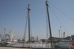 |
Steamship Wharf 41°38′1"N 70°55′16"W |
National Historic Landmark | |
| 10 | Fire Station No. 4 New Bedford Fire Museum The New Bedford Fire Museum is located in the former Fire Station No. 4 at the corner of Sixth and Bedford streets in that city in the U.S. state of Massachusetts. The red brick building, opened in 1867, was one of the oldest continuously operating fire stations in the state when it was closed in... |
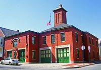 |
79 S. 6th St. 41°37′41"N 70°55′38"W |
1867 building was oldest fire station in state when closed; now home of New Bedford Fire Museum New Bedford Fire Museum The New Bedford Fire Museum is located in the former Fire Station No. 4 at the corner of Sixth and Bedford streets in that city in the U.S. state of Massachusetts. The red brick building, opened in 1867, was one of the oldest continuously operating fire stations in the state when it was closed in... |
|
| 11 | First Baptist Church First Baptist Church (New Bedford, Massachusetts) First Baptist Church is an historic church at 149 William Street in New Bedford, Massachusetts.The church was built in 1829 and added to the National Historic Register in 1975.... |
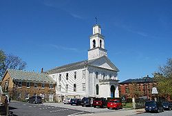 |
149 William St. 41°38′6"N 70°55′44"W |
||
| 12 | Fort Taber District |  |
Wharf Rd. within Fort Rodman Military Reservation 41°35′36"N 70°54′14"W |
||
| 13 | Hazelwood Park | 597-603 Brock Ave. 41°36′24"N 70°54′48"W |
|||
| 14 | Head of the River Historic District | 2-28 Main St., Acushnet; 2-28 Mill Rd., 2-13 Tarkiln Hill Rd. 41°40′54.25"N 70°55′9.07"W |
|||
| 15 | Hotel Waverly Hotel Waverly (New Bedford, Massachusetts) Hotel Waverly is a historic hotel at 1162-1166 Acushnet Avenue in New Bedford, Massachusetts.The hotel was built in 1901 and added to the National Register of Historic Places in 1990.... |
1162-1166 Acushnet Ave. 41°39′26"N 70°55′38"W |
|||
| 16 | Howland Mill Village Historic District Howland Mill Village Historic District Howland Mill Village Historic District is a historic district roughly bounded by Michael Bolton, Winsper, Hemlock Sts., and Rockdale Avenue in New Bedford, Massachusetts.The district was added to the National Register of Historic Places in 1996.... |
Roughly bounded by Bolton, Winsper, Hemlock Sts., and Rockdale Ave. 41°36′58"N 70°56′0"W |
|||
| 17 | Robert C. Ingraham School | 80 Rivet St. 41°37′14.16"N 70°55′20.28"W |
|||
| 18 | Nathan and Mary Johnson Properties Nathan and Mary (Polly) Johnson properties The Nathan and Mary Johnson properties are a National Historic Landmark at 17-19 and 21 Seventh Street in New Bedford, Massachusetts. Originally two structures, one dating to the 1820s and an 1857 house joined with the older one shortly after construction... |
 |
17-19 and 21 7th Street 41°37′59"N 70°55′44"W |
National Historic Landmark; home and meetinghouse of African-American abolitionist couple who took in Frederick Douglass Frederick Douglass Frederick Douglass was an American social reformer, orator, writer and statesman. After escaping from slavery, he became a leader of the abolitionist movement, gaining note for his dazzling oratory and incisive antislavery writing... after he escaped from slavery |
|
| 19 | Lightship No. 114 Lightship No. 114 Lightship No. 114 was a historic lightship at the State Pier in New Bedford, Massachusetts.Built in Portland, Oregon, she left Portland on August 5 for her first station at Fire Island, New York. She arrived on September 20. Serving there until 1942, she was armed for war and placed into service as... |
State Pier 41°38′8"N 70°55′16"W |
|||
| 20 | Merrill's Wharf Historic District Merrill's Wharf Historic District Merrill's Wharf Historic District is a historic district on MacArthur Drive in New Bedford, Massachusetts.The district was built in 1837 and added to the National Register of Historic Places in 1977.... |
MacArthur Dr. 41°37′59"N 70°55′15"W |
|||
| 21 | Moreland Terrace Historic District Moreland Terrace Historic District Moreland Terrace Historic District is a historic district roughly bounded by Moreland Terrace, Ash, Bedford, and Page Streets in New Bedford, Massachusetts.The district was added to the National Register of Historic Places in 1996.... |
Roughly bounded by Moreland Terrace, Ash, Bedford, and Page Sts. 41°37′40"N 70°56′11"W |
|||
| 22 | New Bedford Gas and Edison Light Complex New Bedford Gas and Edison Light Complex New Bedford Gas and Edison Light Complex is a historic district at 180 MacAuthur Drive in New Bedford, Massachusetts.The complex was built in 1856 and added to the National Register of Historic Places in 2002.-References:... |
180 MacAuthur Dr. 41°37′49"N 70°55′16"W |
|||
| 23 | New Bedford Historic District New Bedford Historic District The New Bedford Historic District is a National Historic Landmark District in New Bedford, Massachusetts, United States, west of the community's waterfront. During the 19th century, when the city was the center of the American whaling industry, this was its downtown... |
 |
Bounded by Front St. on the east, Elm St. on the north, Acushnet Ave. on the west, and Commercial St. on the south 41°38′7"N 70°55′27"W |
National Historic Landmark | |
| 24 | New Bedford Whaling National Historical Park New Bedford Whaling National Historical Park New Bedford Whaling National Historical Park is a United States National Historical Park in New Bedford, Massachusetts, and is maintained by the National Park Service. The park commemorates the heritage of the world's preeminent whaling port during the nineteenth century.Established in 1996, the... |
 |
33 William St. 41°38′8.49"N 70°55′26.63"W |
||
| 25 | North Bedford Historic District North Bedford Historic District North Bedford Historic District is a historic district roughly bounded by Summer, Park, Pleasant and Kempton Streets in New Bedford, Massachusetts.The district was added to the National Register of Historic Places in 1979.... |
Roughly bounded by Summer, Park, Pleasant, and Kempton Sts. 41°38′25"N 70°55′49"W |
|||
| 26 | Old Third District Courthouse Old Third District Courthouse The Old Third District Courthouse in New Bedford, Massachusetts, United States, is located at the corner of Second and William streets. It was built in 1853 by Russell Warren in the Greek Revival architectural style, as the home of the New Bedford Institute for Savings, a local bank. After the bank... |
 |
2nd and William Sts. 41°38′9"N 70°55′29"W |
||
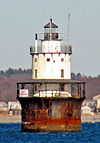
| 27 | Palmer Island Light Station | .jpg) |
New Bedford Harbor 41°37′34"N 70°54′35"W |
ARLHS USA-578 | |
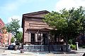
| 28 | William J. Rotch Gothic Cottage William J. Rotch Gothic Cottage The William J. Rotch Gothic Cottage is a National Historic Landmark on 19 Irving Street in New Bedford, Massachusetts.Alexander Jackson Davis built Rotch Cottage in a Gothic Revival style in 1845 and the house was included in "The Architecture of Country Houses" bringing it early fame. The house... |
,_new_bedford_(bristol_county,_massachusetts).jpg) |
19 Irving St. 41°37′49.78"N 70°55′54.52"W |
National Historic Landmark | |
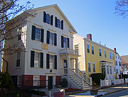
| 29 | William Rotch, Jr. House Rotch-Jones-Duff House and Garden Museum The William Rotch, Jr. House, now the Rotch-Jones-Duff House and Garden Museum, is a National Historic Landmark at 396 County Street in New Bedford, Massachusetts, in the United States. The three families whose names are attached to it were all closely tied to the city's nineteenth-century... |
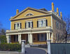 |
396 County Street 41°37′49.07"N 70°55′43.27"W |
National Historic Landmark Early Richard Upjohn Richard Upjohn Richard Upjohn was an English-born architect who emigrated to the United States and became most famous for his Gothic Revival churches. He was partially responsible for launching the movement to such popularity in the United States. Upjohn also did extensive work in and helped to popularize the... house for prominent whaling family |
|
| 30 | Shawmut Diner Shawmut Diner Shawmut Diner is an historic diner at 943 Shawmut Avenue in New Bedford, Massachusetts.The diner was built in 1953. In 1983 the Paleologos family bought and updated the diner. The diner was added to the National Register of Historic Places in 2003. It has been featured on the Food Channel.... |
943 Shawmut Ave. 41°39′32"N 70°56′51"W |
|||
| 31 | Bradford Smith Building Bradford Smith Building Bradford Smith Building is a historic building at 1927-1941 Purchase Street in New Bedford, Massachusetts.The building was built in 1887 and added to the National Historic Register in 1984.... |
1927-1941 Purchase St. 41°39′4"N 70°55′49"W |
|||
| 32 | Thompson Street School Thompson Street School Thompson Street School is a historic school at 58 Crapo Street in New Bedford, Massachusetts.The school was built in 1884 and added to the National Historic Register in 1990.... |
58 Crapo St. 41°37′17"N 70°55′37"W |
|||
| 33 | Times and Olympia Buildings Times and Olympia Buildings Times and Olympia Buildings is a historic site at 908-912 and 880-898 Purchase Street in New Bedford, Massachusetts.The buildings were constructed in 1897 and added to the National Historic Register in 1983.-References:... |
908-912 and 880-898 Purchase St. 41°38′11"N 70°55′36"W |
|||
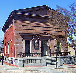
| 34 | U.S. Customhouse | 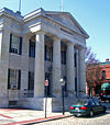 |
Southwestern corner of 2nd and Williams Sts. 41°38′7"N 70°55′29"W |
Oldest U.S. Customs facility in continuous use; Greek Revival public building by Robert Mills Robert Mills (architect) Robert Mills , most famously known for designing the Washington Monument, is sometimes called the first native born American to become a professional architect, though Charles Bulfinch perhaps has a clearer claim to this honor... |
|
| 35 | Union Baptist Church Union Baptist Church (New Bedford, Massachusetts) Union Baptist Church is a historic church at 109 Court Street in New Bedford, Massachusetts.It was built in 1899 and added to the National Register of Historic Places in 2008.... |
109 Court St. 41°38′3.05"N 70°56′5.19"W |
|||
| 36 | Union Street Railway Carbarn, Repair Shop Union Street Railway Carbarn, Repair Shop Union Street Railway Carbarn, Repair Shop is a historic building at 1959 Purchase Street in New Bedford, Massachusetts.The shop was built in 1897 and added to the National Historic Register in 1978.... |
1959 Purchase St. 41°39′7"N 70°55′52"W |
|||
| 37 | Wamsutta Mills Wamsutta Company Wamsutta Company, also known as Wamsutta Mills, was located in New Bedford, Massachusetts, a port known for its whaling ships. The company was named for Wamsutta, the son of an Native American chief who negotiated an early alliance with the English settlers of the Plymouth Colony in the 17th... |
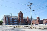 |
Acushnet Ave., Logan, Wamsutta, and N. Front St. 41°39′5.3244"N 70°55′39.4572"W |
||
| 38 | Whitman Mills Whitman Mills Whitman Mills is a historic mill complex at 1, 90 and the east side of Riverside Avenue, the south side, north side and rear of 1 Coffin Avenue, and at 10 Manomet Street in New Bedford, Massachusetts.... |
 |
1, 90, and the eastern side of Riverside Ave., rear 1 and the southern and northern sides of Coffin Ave., and 10 Manomet St. 41°39′45"N 70°55′10"W |
(#83004613) More Info |