

National Register of Historic Places listings in Columbia, South Carolina
Encyclopedia

This is intended to be a complete list of the properties and districts on the National Register of Historic Places
National Register of Historic Places
The National Register of Historic Places is the United States government's official list of districts, sites, buildings, structures, and objects deemed worthy of preservation...
in Columbia
Columbia, South Carolina
Columbia is the state capital and largest city in the U.S. state of South Carolina. The population was 129,272 according to the 2010 census. Columbia is the county seat of Richland County, but a portion of the city extends into neighboring Lexington County. The city is the center of a metropolitan...
, South Carolina
South Carolina
South Carolina is a state in the Deep South of the United States that borders Georgia to the south, North Carolina to the north, and the Atlantic Ocean to the east. Originally part of the Province of Carolina, the Province of South Carolina was one of the 13 colonies that declared independence...
, United States
United States
The United States of America is a federal constitutional republic comprising fifty states and a federal district...
. The locations of National Register properties and districts for which the latitude and longitude coordinates are included below, may be seen on a map.
There are 152 properties and districts listed on the National Register in Richland County
Richland County, South Carolina
Richland County is a county located in the U.S. state of South Carolina. The 2000 U.S. census recorded its population to be 320,677. In 2010, the U.S. Census Bureau recorded that its population had reached 384,504. It is the second most populous county in South Carolina, behind only Greenville...
, including 5 National Historic Landmark
National Historic Landmark
A National Historic Landmark is a building, site, structure, object, or district, that is officially recognized by the United States government for its historical significance...
s. The city of Columbia is the location of 118 of these properties and districts, including all of the National Historic Landmarks; they are listed here, while the 34 properties and districts in the remaining parts of the county are listed separately. Another 3 properties in Columbia were once listed but have been removed.
Current listings
| Landmark name | Image | Date listed | Location | Summary | |
|---|---|---|---|---|---|
| 1 | Allen University Allen University -External links:* -- Official web site... |
1530 Harden St. 34°0′38"N 81°1′14"W |
|||
| 2 | Alston House Alston House (Columbia, South Carolina) Alston House, also known as McDuffie's Antiques, is located at 1811 Gervais St. in Columbia, South Carolina. The Greek Revival style house was built in 1872, and is significant for its architecture. It was added to the National Register of Historic Places in 1979.... |
1811 Gervais St. 34°0′16"N 81°1′25"W |
|||
| 3 | Arcade Building Arcade Building (Columbia, South Carolina) The Arcade Building is a historic enclosed arcade in Columbia, South Carolina that was added to the National Register of Historic Places on November 17,1982.-Architecture and History:... |
1332 Main St. 34°0′12"N 81°2′4"W |
|||
| 4 | Arsenal Hill Arsenal Hill (Columbia) Arsenal Hill is a neighborhood located in Columbia, South Carolina. Arsenal Hill was one of the first residential neighborhoods in the city and was the site of an arsenal during the Civil War. The South Carolina Governor's Mansion is located in Arsenal Hill... |
1800 Lincoln St. 34°0′29"N 81°2′32"W |
|||
| 5 | Babcock Building, South Carolina State Hospital | Bull St. 34°0′51"N 81°1′49"W |
|||
| 6 | Bellevue Historic District | Roughly bounded by Sumter St., Anthony Ave., Bull St., and Elmwood Ave. 34°1′9"N 81°2′19"W |
|||
| 7 | Benedict College Historic District | Roughly bounded by Laurel, Oak, Taylor, and Harden Sts. on the Benedict College Benedict College Benedict College is a historically black, liberal arts college located in Columbia, South Carolina. Founded in 1870 by northern Baptists, it was originally a teachers' college. It has since expanded into a four-year college.-History:... campus 34°0′43"N 81°1′12"W |
|||
| 8 | 226 Bull St. 33°59′24.92"N 81°1′20.88"W |
||||
| 9 | Bethel A.M.E. Church Bethel A.M.E. Church (Columbia, South Carolina) Bethel A.M.E. Church is a historic church at 1528 Sumter Street in Columbia, South Carolina.It was built in 1921 and added to the National Register in 1982.... |
1528 Sumter St. 34°0′25"N 81°2′3"W |
|||
| 10 | Address Restricted | ||||
| 11 | BROWN'S FERRY VESSEL | Address Restricted | |||
| 12 | Building at 1210-1214 Main Street | 1210-1214 Main St. 34°0′4"N 81°2′7"W |
|||
| 13 | Building at 1644 Main Street | 1644 Main St. 34°0′27"N 81°2′11"W |
|||
| 14 | Building at 1722-1724 Main Street | 1722-1724 Main St. 34°0′30"N 81°2′13"W |
|||
| 15 | Building at 303 Saluda Avenue | 303 Saluda Ave. 33°59′34"N 81°1′2"W |
|||
| 16 | Caldwell-Hampton-Boylston House | 829 Richland St. 34°0′32"N 81°2′36"W |
|||
| 17 | John C. Calhoun State Office Building | 1015 Sumter St. 33°59′57"N 81°1′51"W |
|||
| 18 | Canal Dime Savings Bank | 1530 Main St. 34°0′20"N 81°2′8"W |
|||
| 19 | Carver Theatre Carver Theatre (Columbia, South Carolina) Carver Theatre is a building in Columbia, South Carolina that was listed on the National Register of Historic Places in 2003.... |
1519 Harden St. 34°0′37"N 81°1′18"W |
|||
| 20 | Chappelle Administration Building Chappelle Administration Building The Chappelle Administration Building, on the campus of Allen University in Columbia, South Carolina, was designed by John Anderson Lankford, known as the “dean of black architects.” The building name has been spelled Chapelle Administration Building in HABS and NPS reports.It was declared a... |
.jpg) |
1530 Harden St. 34°0′39"N 81°1′16"W |
||
| 21 | Chesnut Cottage | 1718 Hampton St. 34°0′27"N 81°1′37"W |
|||
| 22 | Claussen's Bakery | 2001-2003 Green St. 34°0′0"N 81°1′5"W |
|||
| 23 | Columbia Canal Columbia Canal The Columbia Canal is the surviving canal of a series of canals built by the State of South Carolina in 1824 using the labor of Irish immigrants to provide a direct water routes between the upstate settlements and the towns on the fall line. It is on the Congaree and Broad Rivers in Columbia,... |
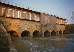 |
Eastern bank of the Broad Broad River (Carolinas) The Broad River is a principal tributary of the Congaree River, about 150 miles long, in western North Carolina and northern South Carolina in the United States. Via the Congaree, it is part of the watershed of the Santee River, which flows to the Atlantic Ocean... and Congaree Congaree River The Congaree River is a short but wide river in South Carolina in the United States; It flows for only 47 miles . The river serves an important role as the final outlet channel for the entire Lower Saluda and Lower Broad watersheds, before merging with the Wateree River just north of Lake Marion to... Rivers from the Diversion dam to the Southern railroad bridge 34°0′6"N 81°3′21"W |
||
| 24 | Columbia Central Fire Station | 1001 Senate St. 33°59′57.57"N 81°2′9.96"W |
|||
| 25 | Columbia City Hall Columbia City Hall The Columbia City Hall, in Columbia, South Carolina, also known as Old United States Court House and Post Office, was built in 1870. It was listed on the National Register of Historic Places in 1973. It includes Renaissance architecture. It served historically as a courthouse and as a post office.... |
Main and Laurel Sts. 34°0′32"N 81°2′15"W |
|||
| 26 | Columbia Electric Street Railway, Light & Power Substation | Main and Laurel Sts. 34°0′9"N 81°2′10"W |
|||
| 27 | Columbia Historic District I | Roughly bounded by Elmwood, Assembly, Laurel, and Wayne Sts. 34°0′37"N 81°2′13"W |
|||
| 28 | Columbia Historic District II | .jpg) |
Roughly bounded by Taylor, Richland, Pickens, and Barnwell Sts.; also Blanding, Laurel, Richland, Calhoun, Marion, Bull, Pickens, Henderson, and Barnwell Sts. 34°0′39"N 81°2′1"W |
Second set of boundaries represents a boundary increase of | |
| 29 | Columbia Mills Building South Carolina State Museum The South Carolina State Museum, located in Columbia, South Carolina, is the largest museum in the Southeastern United States. Positioned on an old shipping canal on the Congaree River that dates back to pre-Civil War times, the museum is widely recognized as a resource for South Carolina history... |
On the Congaree River Congaree River The Congaree River is a short but wide river in South Carolina in the United States; It flows for only 47 miles . The river serves an important role as the final outlet channel for the entire Lower Saluda and Lower Broad watersheds, before merging with the Wateree River just north of Lake Marion to... 33°59′55"N 81°2′53"W |
Now houses the South Carolina State Museum South Carolina State Museum The South Carolina State Museum, located in Columbia, South Carolina, is the largest museum in the Southeastern United States. Positioned on an old shipping canal on the Congaree River that dates back to pre-Civil War times, the museum is widely recognized as a resource for South Carolina history... |
||
| 30 | Columbia Township Auditorium | 1703 Taylor St. 34°0′33"N 81°4′40"W |
|||
| 31 | Confederate Printing Plant | 501 Gervais St. 33°59′53"N 81°2′41"W |
|||
| 32 | Consolidated Building | .jpg) |
1326-1330 Main St. 34°0′12"N 81°2′4"W |
||
| 33 | 1713 Wayne St. 34°0′27"N 81°2′43"W |
||||
| 34 | Curtiss-Wright Hangar | 1400 Jim Hamilton Boulevard 33°58′34"N 81°0′7"W |
|||
| 35 | Debruhl-Marshall House | .jpg) |
1401 Laurel St. 34°0′38"N 81°2′2"W |
||
| 36 | Dovillers-Manning-Magoffin House | 4203 St. Clair Dr. 34°0′34"N 80°58′39"W |
|||
| 37 | Eau Claire Town Hall and Survey Publishing Company Building | 3904 Monticello Rd. 34°2′21"N 81°3′8"W |
|||
| 38 | Ebenezer Lutheran Chapel Ebenezer Lutheran Chapel Ebenezer Lutheran Chapel is a historic chapel at 1301 Richland Street in Columbia, South Carolina.It was built in 1800 and added to the National Register in 1979.... |
1301 Richland St. 34°0′41"N 81°2′9"W |
|||
| 39 | Elmwood Cemetery | 501 Elmwood Ave. 34°0′50"N 81°3′13"W |
|||
| 40 | Elmwood Park Historic District Elmwood Park Historic District (Columbia, South Carolina) The Elmwood Park Historic District is roughly bounded by Elmwood Ave., Main St. and the SAL RR tracks in Columbia, South Carolina. The district is significant for its architecture, which includes Late 19th And Early 20th Century American Movements styles and Late 19th And 20th Century Revival... |
Roughly bounded by Elmwood Ave., Main St. and the former Seaboard Air Line Seaboard Air Line Railroad The Seaboard Air Line Railroad , which styled itself "The Route of Courteous Service," was an American railroad whose corporate existence extended from April 14, 1900, until July 1, 1967, when it merged with the Atlantic Coast Line Railroad, its longtime rival, to form the Seaboard Coast Line... railroad tracks; also 2113 Park St. 34°0′49"N 81°2′34"W |
2113 Park represents a boundary increase of | ||
| 41 | Ensor-Keenan House | 801 Wildwood Ave. 34°2′38"N 81°2′31"W |
|||
| 42 | Fair-Rutherford and Rutherford Houses | 1326 and 1330 Gregg St. 34°0′25"N 81°1′24"W |
|||
| 43 | First Baptist Church First Baptist Church (Columbia, South Carolina) The First Baptist Church in Columbia, South Carolina is a Greek Revival building built in 1856. A convention met here on December 17, 1860 which voted unanimously for South Carolina to secede from the United States, leading to the American Civil War.... |
1306 Hampton St. 34°0′20"N 81°2′0"W |
|||
| 44 | First National Bank | 1208 Washington St. 34°0′13"N 81°2′4"W |
|||
| 45 | First Presbyterian Church First Presbyterian Church (Columbia, South Carolina) The First Presbyterian Church is a historic church building in Columbia, South Carolina. Constructed in 1854, it was added to the National Register of Historic Places on January 25, 1971.-History:... |
1324 Marion St. 34°0′14"N 81°1′51"W |
|||
| 46 | Forest Hills Historic District | Bounded by Gervais St., Manning St., Forest Dr., and Glenwood Rd. 34°0′45.42"N 81°0′12.01"W |
|||
| 47 | Gervais Street Bridge | .jpg) |
Spans the Congaree River Congaree River The Congaree River is a short but wide river in South Carolina in the United States; It flows for only 47 miles . The river serves an important role as the final outlet channel for the entire Lower Saluda and Lower Broad watersheds, before merging with the Wateree River just north of Lake Marion to... 33°59′47"N 81°2′55"W |
Extends into West Columbia West Columbia, South Carolina West Columbia is a city in Lexington County, South Carolina, United States. The population was 13,064 at the 2000 census. It is part of the Columbia, South Carolina Metropolitan Statistical Area.... in Lexington County National Register of Historic Places listings in Lexington County, South Carolina This is a list of the National Register of Historic Places listings in Lexington County, South Carolina.This is intended to be a complete list of the properties and districts on the National Register of Historic Places in Lexington County, South Carolina, United States... |
|
| 48 | Good Samaritan-Waverly Hospital | 2204 Hampton St. 34°0′37.45"N 81°1′8.3"W |
|||
| 49 | Granby Mill Village Historic District | Roughly bounded by Catawba, Gist, Heyward, and Church Sts. 33°58′59"N 81°2′22"W |
|||
| 50 | Greyhound Bus Depot Greyhound Bus Depot (Columbia, South Carolina) The Greyhound Bus Depot is a former Greyhound Lines intercity bus station in Columbia, South Carolina. It is at 1200 Blanding Street in downtown Columbia. The depot was named to the National Register of Historic Places on December 28, 1989. After the bus terminal was closed, the building became a... |
.jpg) |
1200 Blanding St. 34°0′29"N 81°2′8"W |
||
| 51 | Hale-Elmore-Seibels House Hale-Elmore-Seibels House The Hale-Elmore-Seibels House or Seibels House is a historic building located in Columbia, South Carolina. Records of the exact year of its construction were destroyed in 1865 during the burning of the city by Union soldiers serving under General William Tecumseh Sherman. The best guess for the... |
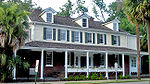 |
1601 Richland St. 34°0′46"N 81°1′53"W |
||
| 52 | .jpg) |
1616 Blanding St. 34°0′34"N 81°1′45"W |
Robert Mills House | ||
| 53 | Hampton-Preston House Hampton-Preston House The Hampton-Preston House located at 1615 Blanding Street in Columbia, South Carolina, is a historic mansion that was the home of members of the prominent Hampton family. It was listed in the National Register of Historic Places on July 29, 1969.... |
1615 Blanding St. 34°0′37"N 81°1′46"W |
|||
| 54 | Harden Street Substation | 1901 Harden St. 34°0′53"N 81°1′25"W |
|||
| 55 | Heslep House | 203 Saluda Ave. 33°59′31"N 81°1′0"W |
|||
| 56 | Horry-Guignard House | 1527 Senate St. 34°0′6"N 81°1′38"W |
|||
| 57 | House of Peace Synagogue House of Peace Synagogue The House of Peace Synagogue is a former synagogue of the Beth Shalom Congregation in Columbia, South Carolina. It was originally located at 1318 Park Street. After the congregation moved in the 1935, the building was used for the Big Apple Club, which was an African-American night club. It was... |
.jpg) |
Hampton and Park Sts. 34°0′15"N 81°2′18"W |
Also known as the Big Apple Club. | |
| 58 | 912 Lady St. 34°0′3"N 81°2′18"W |
||||
| 59 | Kress Building | 1508 Main St. 34°0′20"N 81°2′8"W |
|||
| 60 | Lace House | 803 Richland St. 34°0′31"N 81°2′39"W |
|||
| 61 | Ladson Presbyterian Church Ladson Presbyterian Church Ladson Presbyterian Church is a historic church at 1720 Sumter Street in Columbia, South Carolina.It was built in 1896 and added to the National Register in 1998.... |
1720 Sumter St. 34°0′33"N 81°2′7"W |
|||
| 62 | Laurelwood | Address Restricted | |||
| 63 | Lever Building | 1613 Main St. 34°0′24"N 81°2′12"W |
|||
| 64 | Logan School | 815 Elmwood Ave. 34°0′43"N 81°2′42"W |
|||
| 65 | 1727 Hampton St. 34°0′29"N 81°1′35"W |
||||
| 66 | Lutheran Theological Seminary Building: Beam Dormitory Lutheran Theological Seminary Building: Beam Dormitory The Lutheran Theological Seminary Building: Beam Dormitory was the first permanent building at the Lutheran Theological Southern Seminary in Columbia, South Carolina. It was built in 1911 based on a design by noted Virginia architect Charles M. Robinson. The structure was built by Wise Granite... |
4201 Main St. 34°2′32"N 81°2′4"W |
|||
| 67 | Lyles-Gudmundson House | Address Restricted 33°59′32"N 81°0′55"W |
|||
| 68 | Mann-Simons Cottage | 1403 Richland St. 34°0′42"N 81°2′4"W |
|||
| 69 | McCord House | 1431 Pendleton St. 33°59′59"N 81°1′41"W |
|||
| 70 | McMaster School McMaster School The McMaster School, built in 1911, is an historic building located at 1106 Pickens Street on the corner of Senate Street in Columbia, South Carolina. It was designed by noted Columbia architect William Augustus Edwards of the firm of Edwards and Walter. It was named for Col. F. W... |
1106 Pickens St. 34°0′8"N 81°1′34"W |
|||
| 71 | Millwood Millwood (Richland County, South Carolina) Millwood is the site and ruins of an antebellum plantation house at 6100 Garner's Ferry Road , Columbia, South Carolina. It was owned by Colonel Wade Hampton II and was the boyhood home of the Confederate general, South Carolina governor, and U.S. Senator Wade Hampton III. After the death of Wade... |
,_u.s._route_76_(garners_ferry_road),_columbia_vicinity_(richland_county,_south_carolina).jpg) |
East of Columbia on Garner's Ferry Rd. 33°59′16"N 80°57′45"W |
Home of Wade Hampton II Wade Hampton II Wade Hampton II was an American plantation owner and soldier in the War of 1812. He was a member of the Hampton family, whose influence was strong in South Carolina politics and social circles for nearly 100 years.... . |
|
| 72 | Moore-Mann House | 1611 Hampton St. 34°0′27"N 81°1′43"W |
|||
| 73 | National Loan and Exchange Bank Building | 1338 Main St. 34°0′13"N 81°2′5"W |
|||
| 74 | Nipper Creek (38RD18) | Address Restricted | |||
| 75 | North Carolina Mutual Building | 1001, 1001½, and 1003 Washington St. 34°0′10"N 81°2′17"W |
|||
| 76 | North Columbia Fire Station No. 7 | 2622 N. Main St. 34°1′14"N 81°2′32"W |
|||
| 77 | Old Campus District, University of South Carolina Old Campus District, University of South Carolina The Old Campus District, University of South Carolina, is an historic district centered around The Horseshoe on the main campus of the University of South Carolina in Columbia, South Carolina, in the United States... |
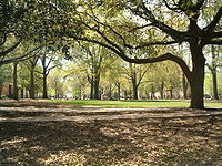 |
Bounded by Pendleton, Sumter, Pickens, and Green Sts. 33°59′47"N 81°1′43"W |
||
| 78 | Old Shandon Historic District | Roughly bounded by Cypress, Lee, Maple, Preston, and Woodrow St. 34°0′4"N 81°0′15"W |
|||
| 79 | Olympia Mill | 500 Heyward St. 33°58′58"N 81°2′11"W |
|||
| 80 | Pacific Community Association Building | 701 Whaley St. and 214 Wayne St. 33°59′8.22"N 81°2′7.36"W |
|||
| 81 | Palmetto Building | .jpg) |
1400 Main St. 34°0′14"N 81°2′5"W |
||
| 82 | Palmetto Compress and Warehouse Company Building | 617 Devine St. 33°59′29"N 81°2′20"W |
|||
| 83 | 3000 Forest Dr. 34°0′54"N 80°59′54"W |
||||
| 84 | 3004 Forest Dr. 34°0′55"N 80°59′52"W |
||||
| 85 | Randolph Cemetery | Western terminus of Elmwood Ave. 34°0′34"N 81°3′15"W |
|||
| 86 | Richland Cotton Mill | 211-221 Main St. 33°59′18"N 81°1′43"W |
|||
| 87 | 1529 Assembly St. 34°0′19"N 81°2′17"W |
||||
| 88 | Sidney Park Colored Methodist Episcopal Church | 1114 Blanding St. 34°0′26"N 81°2′15"W |
|||
| 89 |  |
2025 Marion St. 34°0′49"N 81°2′9"W |
|||
| 90 | South Carolina Governor's Mansion South Carolina Governor's Mansion The South Carolina Governor's Mansion is a historic U.S. governor's mansion in the Arsenal Hill neighborhood of Columbia, South Carolina and the official residence of the Governor of South Carolina. It is a Federal style home influenced by British Colonial plantations... |
800 Richland St. 34°0′28"N 81°2′37"W |
|||
| 91 | South Carolina State Armory South Carolina State Armory The South Carolina State Armory, built in 1905, is an historic National Guard building located at 1219 Assembly Street near the State House in Columbia, South Carolina. It was designed in the Early Commercial style by noted Columbia architect William Augustus Edwards and his partner Frank C. Walter... |
1219 Assembly St. 34°0′5.3"N 81°2′9.6"W |
|||
| 92 | South Carolina State Hospital, Mills Building Mills Building, South Carolina State Hospital Mills Building, South Carolina State Hospital, formerly known as the South Carolina Lunatic Asylum, is a building designed by Robert Mills in Columbia, South Carolina.... |
2100 Bull St. 34°0′52"N 81°2′0"W |
|||
| 93 | South Carolina Statehouse South Carolina State House The South Carolina State House is the building housing the government of the U.S. state of South Carolina. The building houses the South Carolina General Assembly and the offices of the Governor and Lieutenant Governor of South Carolina. Until 1971, it also housed the Supreme Court... |
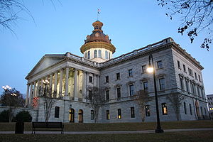 |
Main St. 34°0′1"N 81°1′59"W |
||
| 94 | Southern Cotton Oil Company | 737 Gadsden St. 33°59′34"N 81°2′16"W |
|||
| 95 | A. Fletcher Spigner House | 2028 Wheat St. 33°59′45.33"N 81°0′53.88"W |
|||
| 96 | Supreme Court of South Carolina Building | Northwestern corner of the junction of Gervais and Sumter Sts. 34°0′6"N 81°1′57"W |
|||
| 97 | Sylvan Building | 1500 Main St. 34°0′18"N 81°2′7"W |
|||
| 98 | Taylor House | 1505 Senate St. 34°0′5"N 81°1′41"W |
|||
| 99 | Town Theatre | 1012 Sumter St. 34°0′0"N 81°1′51"W |
|||
| 100 | Trinity Episcopal Church Trinity Episcopal Cathedral (Columbia, South Carolina) Trinity Episcopal Church, now known as Trinity Episcopal Cathedral, is the first Episcopal and the oldest surviving sanctuary in Columbia, South Carolina. It is a Gothic Revival church that is modeled after York Minster in York, England... |
1100 Sumter St. 34°0′3"N 81°1′52"W |
|||
| 101 | Union Station | 401 S. Main St. 33°59′25"N 81°1′46"W |
|||
| 102 | University Neighborhood Historic District University Neighborhood Historic District (Columbia, South Carolina) The University Neighborhood Historic District is roughly bounded by Gervais St., the Southern Railroad Cut, Greene St. and Pickens St. in Columbia, South Carolina. The district is significant for its architecture, including Late Victorian, Late 19th And 20th Century Revival styles. It was added... |
Roughly bounded by Gervais St., the Southern railroad cut, Greene St., and Pickens St. 34°0′3"N 81°1′19"W |
|||
| 103 | US Courthouse | 1100 Laurel St. 34°0′31"N 81°2′17"W |
|||
| 104 | Veterans Hospital | William Jennings Bryan Dorn Veterans Affairs Medical Center, University of South Carolina University of South Carolina The University of South Carolina is a public, co-educational research university located in Columbia, South Carolina, United States, with 7 surrounding satellite campuses. Its historic campus covers over in downtown Columbia not far from the South Carolina State House... School of Medicine 33°58′39"N 80°57′40"W |
|||
| 105 | Wade Hampton State Office Building | 1015 Sumter St. 34°0′5"N 81°1′56"W |
|||
| 106 | Wallace-McGee House | 415 Harden St. 33°59′43"N 81°0′53"W |
|||
| 107 | Wardlaw Junior High School | 1003 Elmwood Ave. 34°0′45"N 81°2′33"W |
|||
| 108 | Washington Street United Methodist Church Washington Street United Methodist Church Washington Street United Methodist Church is a historic church at 1401 Washington Street in Columbia, South Carolina.It was built in 1872 and added to the National Register in 1970.... |
1401 Washington St. 34°0′19"N 81°1′53"W |
|||
| 109 | Waverly Historic District | Roughly bounded by Hampton St., Heidt St., Gervais St., and Harden St. 34°0′33"N 81°1′3"W |
|||
| 110 | Wesley Methodist Church Wesley Methodist Church (Columbia, South Carolina) Wesley Methodist Church is a historic church at 1727 Gervais Street in Columbia, South Carolina.It was built in 1911 and added to the National Register in 2009.... |
1727 Gervais St. 34°0′15.08"N 81°1′28.17"W |
|||
| 111 | West Gervais Street Historic District | Roughly bounded by Gadsen, Senate, Park, and Lady Sts. 33°59′56"N 81°2′21"W |
|||
| 112 | 1527 Gervais St. 34°0′11"N 81°1′40"W |
||||
| 113 | 1808 Washington St. 34°0′24"N 81°1′30"W |
||||
| 114 | 1705 Hampton St. 34°0′29"N 81°1′38"W |
||||
| 115 | Woodrow Memorial Presbyterian Church Woodrow Memorial Presbyterian Church Woodrow Memorial Presbyterian Church is a historic church at 2221 Washington Street in Columbia, South Carolina.It was built in 1885 and added to the National Register in 1979.... |
2221 Washington St. 34°0′34"N 81°1′5"W |
|||
| 116 | World War Memorial Building | 920 Sumter St., at its junction with Pendleton St. 33°59′55"N 81°1′48"W |
|||
| 117 | Zimmerman House | 1332 Pickens St. 34°0′19"N 81°1′41"W |
|||
| 118 | Zimmerman School | 1336 Pickens St. 34°0′21"N 81°1′41"W |
Former listings
| Landmark name | Image | Dates | Location | Summary | |
|---|---|---|---|---|---|
| 1 | Columbia High School | (delisted) | 1323 Washington Street | Demolished | |
| 2 | South Carolina Penitentiary | (delisted) | 1511 Williams Street | Demolished | |
| 3 | South Carolina Dispensary Office Building | (delisted) | 1205 Pulaski Street |
See also
- List of National Historic Landmarks in South Carolina
- National Register of Historic Places listings in South Carolina