

National Register of Historic Places listings in Center Township, Marion County, Indiana
Encyclopedia

This is intended to be a complete list of the properties and districts on the National Register of Historic Places
National Register of Historic Places
The National Register of Historic Places is the United States government's official list of districts, sites, buildings, structures, and objects deemed worthy of preservation...
in Center Township
Center Township, Marion County, Indiana
Center Township is one of nine townships in Marion County, Indiana, in the United States. As of the 2000 census, its population was 167,055, making it the most populated township in Marion County...
, Marion County
Marion County, Indiana
Marion County is a county located in the U.S. state of Indiana. Census 2010 recorded a population of 903,393, making it the largest county in the state and 55th most populated county in the country, greater than the population of six states. The county seat is Indianapolis, the state capital and...
, Indiana
Indiana
Indiana is a US state, admitted to the United States as the 19th on December 11, 1816. It is located in the Midwestern United States and Great Lakes Region. With 6,483,802 residents, the state is ranked 15th in population and 16th in population density. Indiana is ranked 38th in land area and is...
, United States
United States
The United States of America is a federal constitutional republic comprising fifty states and a federal district...
. Latitude and longitude coordinates are provided for many National Register properties and districts; these locations may be seen together in a Google map.
There are 223 properties and districts listed on the National Register in the county, including 8 National Historic Landmark
National Historic Landmark
A National Historic Landmark is a building, site, structure, object, or district, that is officially recognized by the United States government for its historical significance...
s. Because Indianapolis is coextensive
Unigov
Unigov is the name adopted by the city of Indianapolis to describe its consolidated city–county government. By an act of the Indiana state legislature, Indianapolis consolidated with the government of Marion County in 1970. Within Unigov are eleven "included towns", which maintain some of their own...
with Marion County, properties are listed by township rather than by city or town. Center Township is the location of 163 of these properties and districts, including 5 of the National Historic Landmarks; these properties and districts are listed here. Properties and districts in Marion County's other townships are listed separately. One district, the Indianapolis Park and Boulevard System
Indianapolis Park and Boulevard System
The Indianapolis Park and Boulevard System is a group of parks, parkways, and boulevards in Indianapolis, Indiana that was designed by landscape architect George Edward Kessler in the early part of the twentieth century. Also known as the Kessler System, the district includes and has shaped the...
, is split between Center Township and three other townships, and is thus included on both lists. Eight other properties, including seven in Center Township, were once listed but have been removed.
Current listings
| Landmark name | Image | Date listed | Location | Summary | |
|---|---|---|---|---|---|
| 1 | The Alameda | 37 W. St. Clair St. 39°46′41"N 86°9′33"W |
|||
| 2 | The Alexandra | 402-416 N. New Jersey St. and 332-336 E. Vermont St. 39°46′22"N 86°9′2"W |
|||
| 3 | The Ambassador | 39 E. 9th St. 39°46′44"N 86°9′21"W |
|||
| 4 | Athenaeum (Das Deutsche Haus) Athenæum (Das Deutsche Haus) The Athenæum, originally named Das Deutsche Haus , is the most ornate and best-preserved building affiliated with the German American community of Indianapolis. Once used as a German American turnverein and clubhouse, it currently houses many groups, organizations, and businesses... |
 |
401 E. Michigan St. 39°46′24"N 86°9′1"W |
||
| 5 | Crispus Attucks High School Crispus Attucks High School Crispus Attucks High School of Indianapolis Public Schools in Indianapolis, Indiana is named for Crispus Attucks , a black laborer killed at the Boston Massacre whom many regarded as a revolutionary leader... |
1140 N. Martin Luther King, Jr., St. 39°46′58"N 86°10′12"W |
|||
| 6 | L.S. Ayres Annex Warehouse | 14-22 W. Maryland St. 39°45′57"N 86°9′30"W |
|||
| 7 | The Baker | 310 N. Alabama St. and 341 Massachusetts Ave. 39°46′18"N 86°9′9"W |
|||
| 8 | Balmoral Court | 3055 N. Meridian St. 39°48′43"N 86°9′22"W |
|||
| 9 | Bals-Wocher House | 951 N. Delaware St. 39°46′49"N 86°9′13.2"W |
|||
| 10 | Bates-Hendricks House | 1526 S. New Jersey St. 39°44′47"N 86°9′3"W |
|||
| 11 | Bethel A.M.E. Church | 414 W. Vermont St. 39°46′23"N 86°9′56"W |
|||
| 12 | The Blacherne | 402 N. Meridian St. 39°46′22"N 86°9′29"W |
|||
| 13 | Broad Ripple Firehouse-Indianapolis Fire Department Station 32 | 6330 Guilford Ave. 39°52′15"N 86°8′35"W |
|||
| 14 | Broad Ripple Park Carousel Broad Ripple Park Carousel Broad Ripple Park Carousel, also known as White City Carousel and Children's Museum Carousel, is an antique carousel in The Children's Museum of Indianapolis. It was installed in 1917 at an amusement park near the White River in Indianapolis, Indiana, where it remained until the building housing it... |
Meridian and 30th Sts. 39°48′39"N 86°9′21"W |
|||
| 15 | The Buckingham The Buckingham (Indianapolis, Indiana) The Buckingham in Indianapolis, Indiana, is a multiple unit dwelling that was built in 1909. It was listed on the U.S. National Register of Historic Places in 1992.... |
3101-3119 N. Meridian St. 39°48′44"N 86°9′22"W |
|||
| 16 | The Burton | 821-823 N. Pennsylvania St. 39°46′42"N 86°9′20"W |
|||
| 17 | William Buschmann Block | 968-972 Fort Wayne Ave. 39°46′51"N 86°9′0"W |
|||
| 18 | Bush Stadium Bush Stadium Owen J. "Donie" Bush Stadium is the name of a stadium formerly used by minor league baseball team Indianapolis Indians in Indianapolis, Indiana. Its street address is 1501 West 16th Street... |
1501 W. 16th St. 39°47′15"N 86°11′21"W |
|||
| 19 | Byram-Middleton House | 1828 N. Illinois St. 39°47′29"N 86°9′34"W |
|||
| 20 | The Cathcart The Cathcart The Cathcart is a historic apartment building located at 103 E. 9th St. in Indianapolis, Indiana, United States. It was built in 1909 amid an apartment-building boom in what is now central Indianapolis.... |
103 E. 9th St. 39°46′44"N 86°9′20"W |
|||
| 21 | Central Court Historic District Central Court Historic District The Central Court Historic District is a historic district and neighborhood of the city of Indianapolis in northern Center Township, Marion County, Indiana, United States. Built around Central Court near the intersection of Thirty-sixth Street and Central Avenue, the neighborhood consists of... |
3529-3575 Central Ave., 515-551 E. 36th St., and Central Ct. 39°49′20"N 86°8′53"W |
|||
| 22 | Central Library (Indianapolis-Marion County Public Library) Indianapolis-Marion County Public Library The Indianapolis Public Library is the public library system that serves the citizens of Marion County, Indiana, United States and its largest city, Indianapolis... |
40 E. St. Clair St. 39°46′42"N 86°9′24"W |
|||
| 23 | Chatham-Arch Historic District Chatham Arch, Indianapolis Chatham Arch is a neighborhood located immediately east of Downtown Indianapolis, Indiana. This neighborhood is one of the oldest in Indianapolis, dating back to the mid 19th century... |
Roughly bounded by Interstate 65 Interstate 65 Interstate 65 is a major Interstate Highway in the United States. The southern terminus is located at an intersection with Interstate 10 in Mobile, Alabama, and its northern terminus is at an interchange with Interstate 90 , U.S. Route 12, and U.S... , College Ave., and 10th, 11th, North, New Jersey, Cleveland, and East Sts. 39°46′42"N 86°8′48"W |
|||
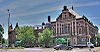
| 24 | Christ Church Cathedral Christ Church Cathedral, Indianapolis Christ Church Cathedral is the cathedral church of the Episcopal Diocese of Indianapolis. Christ Church Cathedral is the oldest religious building in continuous use in Indianapolis.- History :... |
131 Monument Circle 39°46′9"N 86°9′27"W |
|||
| 25 | Christian Park School No. 82 | 4700 English Ave. 39°45′38"N 86°5′20"W |
|||
| 26 | Circle Theater | 45 Monument Circle 39°46′5"N 86°9′26"W |
|||
| 27 | City Market Indianapolis City Market The Indianapolis City Market was founded in 1812 and in 1886 was officially opened in its current facility. The city market is also on the National Register of Historic Places. The Indianapolis City Market will also play host for some events for the Super Bowl 2012 in Indianapolis.... |
222 E. Market St. 39°46′7"N 86°9′12"W |
|||
| 28 | Cole Motor Car Company Cole Motor Car Company The Cole Motor Car Company was an early automobile maker based in Indianapolis, Indiana. Cole automobiles were built from 1908 until 1925. They were quality-built luxury cars. The make is a pioneer of the V-8 engine.- Early years :... |
730 E. Washington St. 39°46′2"N 86°8′39"W |
|||
| 29 | The Colonial The Colonial (Indianapolis, Indiana) The Colonial in Indianapolis, Indiana is a complex of buildings. It was listed on the National Register of Historic Places in 1983.... |
126 E. Vermont St. and 402-408 N. Delaware St. 39°46′22"N 86°9′15"W |
|||
| 30 | Columbia Club Columbia Club The Columbia Club is a private hotel and clubhouse located on Monument Circle in downtown Indianapolis, Indiana. The current structure was built in 1925 as the third home to a private club of the same name.-Club history:... |
121 Monument Circle 39°46′8"N 86°9′26"W |
|||
| 31 | Cottage Home Historic District Cottage Home Historic District The Cottage Home Historic District is a historic district and neighborhood located on the near east side of Indianapolis, Indiana. A small portion of Cottage Home is listed on the National Register of Historic Places while a larger area is listed on the state and local levels... |
Dorman and St. Clair Sts. 39°46′40"N 86°8′17"W |
|||
| 32 | Coulter Flats | 2161 N. Meridian St. 39°47′48"N 86°9′25"W |
|||
| 33 | Crown Hill Cemetery Crown Hill Cemetery Crown Hill Cemetery, located at 700 West 38th Street in Indianapolis, is the third largest non-governmental cemetery in the United States at . It contains of paved road, over 150 species of trees and plants, over 185,000 graves, and services roughly 1,500 burials per year. It sits on the highest... |
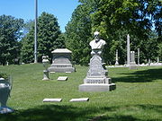 |
Boulevard Pl., W. 32nd St., and Northwestern Ave. 39°49′8"N 86°10′21"W |
||
| 34 | Crown Hill National Cemetery Crown Hill National Cemetery Crown Hill National Cemetery is a United States National Cemetery located in the city of Indianapolis in Marion County, Indiana. It encompasses of Crown Hill Cemetery, and as of the end of 2005, had 795 interments... |
700 W. 38th St. 39°49′0"N 86°10′23"W |
|||
| 35 | The Dartmouth The Dartmouth (Indianapolis, Indiana) The Dartmouth is an apartment building in downtown Indianapolis, Indiana, United States. Built in 1930, it was listed on the National Register of Historic Places in 1983.... |
221 E. Michigan St. 39°46′29"N 86°9′12"W |
|||
| 36 | Delaware Court | 1001-1015 N. Delaware St. 39°46′52"N 86°9′13"W |
|||
| 37 | Delaware Flats | 120-128 N. Delaware St. 39°46′8"N 86°9′16"W |
|||
| 38 | The Devonshire | 412 N. Alabama St. 39°46′24"N 86°9′9"W |
|||
| 39 | The Emelie | 326-330 N. Senate Ave. and 301-303 W. Vermont St. 39°46′21"N 86°9′48"W |
|||
| 40 | Emerson Heights Historic District | Roughly bounded by Emerson Ave., Linwood Ave., and E. 10th and E. Michigan Sts. 39°46′40.35"N 86°5′17.41"W |
|||
| 41 | Esplanade Apartments | 3015 N. Pennsylvania St. 39°48′39"N 86°9′16"W |
|||
| 42 | Fidelity Trust Building | 148 E. Market St. 39°46′7"N 86°9′17"W |
|||
| 43 | Flanner House Homes | Roughly bounded by Dr. Martin Luther King, Jr., Dr., 12th St., Fall Creek Parkway East Dr., and Lynn St. 39°47′4"N 86°10′16"W |
|||
| 44 | Fletcher Place Historic District Fletcher Place Fletcher Place is a historic district and neighborhood in the city of Indianapolis, Indiana.The neighborhood is clearly defined by I-70/I-65 to the south. East Street defines the neighborhood to the west... |
Roughly bounded by railroad tracks, Interstates 65 Interstate 65 Interstate 65 is a major Interstate Highway in the United States. The southern terminus is located at an intersection with Interstate 10 in Mobile, Alabama, and its northern terminus is at an interchange with Interstate 90 , U.S. Route 12, and U.S... /70 Interstate 70 Interstate 70 is an Interstate Highway in the United States that runs from Interstate 15 near Cove Fort, Utah, to a Park and Ride near Baltimore, Maryland. It was the first Interstate Highway project in the United States. I-70 approximately traces the path of U.S. Route 40 east of the Rocky... , East St., and Virginia Ave. 39°45′37"N 86°8′45"W |
|||
| 45 | Calvin I. Fletcher House | 1031 N. Pennsylvania St. 39°46′55"N 86°9′19"W |
|||
| 46 | Benjamin Franklin Public School Number 36 | 2801 N. Capitol Ave. 39°48′32"N 86°9′38"W |
|||
| 47 | General German Protestant Orphans Home | 1404 S. State St. 39°44′53"N 86°7′54"W |
|||
| 48 | Gibson Company Building | 433-447 N. Capitol Ave. 39°46′24.5"N 86°9′37.98"W |
|||
| 49 | The Glencoe | 627 N. Pennsylvania St. 39°46′35"N 86°9′20"W |
|||
| 50 | Alfred M. Glossbrenner Mansion | 3202 N. Meridian St. 39°48′50"N 86°9′25"W |
|||
| 51 | Golden Hill Historic District | Roughly bounded by 36th St., 37th St., Governors Rd., the rear lot lines behind Golden Hill Dr., and Central Canal 39°49′9"N 86°11′6"W |
|||
| 52 | The Gramse | 2203 N. Broadway St. 39°47′52"N 86°8′46"W |
|||
| 53 | The Grover | 615 N. Pennsylvania St. 39°46′34"N 86°9′20"W |
|||
| 54 | Hammond Block (Budnick's Trading Mart) | 301 Massachusetts Ave. 39°46′17"N 86°9′13"W |
|||
| 55 | Benjamin Harrison House Benjamin Harrison Home The Benjamin Harrison Home, in the Old Northside Historic District of Indianapolis, Indiana, was the home of the Twenty-third President of the United States, Benjamin Harrison. Benjamin Harrison had the house built in the 1870s of red brick, and it had sixteen rooms... |
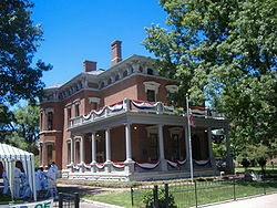 |
1204 N. Delaware St. 39°47′2"N 86°9′15"W |
||
| 56 | HCS Motor Car Company | 1402 N. Capitol Ave. 39°47′11.01"N 86°9′43.26"W |
|||
| 57 | Heier's Hotel | 10-18 S. New Jersey St. 39°45′59"N 86°9′3"W |
|||
| 58 | Herron-Morton Place Historic District Herron-Morton Place Historic District Herron-Morton Place is a historic district in Indianapolis, Indiana, dedicated to restoration and renewal. The boundaries of the neighborhood are East 16th Street on the south, East 22nd Street on the north, the alley west of North Pennsylvania on the west, and the alley east of Central Avenue on... |
Roughly bounded by Central Ave. and 16th, Pennsylvania, and 22nd Sts. 39°47′34"N 86°9′9"W |
|||
| 59 | John Fitch Hill House | 1523 Southeastern Ave. 39°45′50.5"N 86°7′57"W |
|||
| 60 | Holy Rosary-Danish Church Historic District | Roughly bounded by Virginia Ave., Interstates 65 Interstate 65 Interstate 65 is a major Interstate Highway in the United States. The southern terminus is located at an intersection with Interstate 10 in Mobile, Alabama, and its northern terminus is at an interchange with Interstate 90 , U.S. Route 12, and U.S... /70 Interstate 70 Interstate 70 is an Interstate Highway in the United States that runs from Interstate 15 near Cove Fort, Utah, to a Park and Ride near Baltimore, Maryland. It was the first Interstate Highway project in the United States. I-70 approximately traces the path of U.S. Route 40 east of the Rocky... , and S. East St. 39°45′23"N 86°8′50"W |
|||
| 61 | Hotel Washington | 32 E. Washington St. 39°46′2"N 86°9′25"W |
|||
| 62 | Independent Turnverein | 902 N. Meridan St. 39°46′45"N 86°9′28"W |
|||
| 63 | Indiana Avenue Historic District | 500 block of Indiana Ave. between North St., Central Canal, Michigan, and West Sts. 39°46′29"N 86°9′57"W |
|||
| 64 | Indiana Oxygen Company | 351 S. East St. 39°45′41"N 86°8′56"W |
|||
| 65 | Indiana State Capitol |  |
W. Washington St. 39°46′7"N 86°9′45"W |
||
| 66 | Indiana State Federation of Colored Women's Clubs | 2034 N. Capitol Ave. 39°47′37"N 86°9′42"W |
|||
| 67 | Indiana State Library and Historical Building Indiana State Library and Historical Building The Indiana State Library and Historical Bureau is a public library building, located in Indianapolis, Indiana, is the largest public library in the state of Indiana housing over 60,000 manuscripts... |
140 N. Senate Ave. 39°46′11"N 86°9′50"W |
|||
| 68 | Indiana Theatre | 134 W. Washington St. 39°46′2"N 86°9′39"W |
|||
| 69 | Indiana World War Memorial Plaza Indiana World War Memorial Plaza The Indiana World War Memorial Plaza is an urban feature located in Indianapolis, Indiana, originally built to honor the veterans of World War I. The five-city-block plaza was conceived in 1919 as a location for the national headquarters of the American Legion and a memorial to the state's and... |
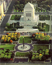 |
Bounded by St. Clair, Pennsylvania, Vermont, and Meridian Sts. 39°46′30"N 86°9′24"W |
||
| 70 | Indianapolis Fire Headquarters and Municipal Garage | 301 E. New York St. and 235 N. Alabama St. 39°46′14"N 86°9′8"W |
|||
| 71 | Indianapolis Masonic Temple Indianapolis Masonic Temple The Indianapolis Masonic Temple in Indianapolis, Indiana is a building in the Classical Revival architectural style. It was listed on the National Register of Historic Places in 2008.... |
525 N. Illinois Ave. 39°46′38"N 86°9′33"W |
|||
| 72 | Indianapolis News Building | 30 W. Washington St. 39°46′2"N 86°9′33"W |
|||
| 73 | Indianapolis Park and Boulevard System Indianapolis Park and Boulevard System The Indianapolis Park and Boulevard System is a group of parks, parkways, and boulevards in Indianapolis, Indiana that was designed by landscape architect George Edward Kessler in the early part of the twentieth century. Also known as the Kessler System, the district includes and has shaped the... |
Roughly bounded by 38th St., Emerson, Southern and Tibbs Aves., extending along Fall Creek and Pleasant Run Parkways to Shadeland 39°47′25"N 86°8′38"W |
Extends into Lawrence, Warren, and Washington townships, elsewhere in Marion County | ||
| 74 | Indianapolis Union Railroad Station | 39 Jackson Pl. 39°45′47"N 86°9′34"W |
|||
| 75 | Indianapolis Union Station-Wholesale District | Roughly bounded by Capitol Ave. and Maryland, Delaware, and South Sts. 39°45′51"N 86°9′30"W |
|||
| 76 | Indianapolis White Castle Number 3 | 660 Fort Wayne Ave. 39°46′35.7"N 86°9′16.5"W |
|||
| 77 | Charles Kuhn House | 340 W. Michigan St. 39°46′27"N 86°9′52"W |
|||
| 78 | Laurel and Prospect District | 1335 to 1419 E. Prospect St. 39°45′8"N 86°8′7"W |
|||
| 79 | Louis Levey Mansion | 2902 N. Meridian St. 39°48′30"N 86°9′24"W |
|||
| 80 | Linwood Colonial Apartments | 4421 E. Washington St. and 55 and 56 S. Linwood Ave. 39°46′14"N 86°5′34"W |
|||
| 81 | Lockefield Garden Apartments Lockefield Gardens Lockefield Gardens was the first public housing built in Indianapolis. Built during the years of 1935 to 1938, it was built exclusively for low income blacks in Indianapolis. The complex was closed in 1976, and a number of structures were demolished in the early 1980s... |
900 Indiana Ave. 39°46′42"N 86°10′26"W |
|||
| 82 | Lockerbie Square Historic District Lockerbie Square Historic District Lockerbie Square Historic District is a historic district on the National Register of Historic Places within Indianapolis, Indiana, listed on February 23, 1973, with a boundary increase on July 28, 1987. It is noted for its Federal, Italianate, and Queen Anne style architecture... |
 |
Indianapolis; specifically, bounded by Michigan and Davidson Sts., New York Ave., and New Jersey St. 39°46′16"N 86°8′52"W |
Specific boundaries represent a boundary increase of | |
| 83 | The Lodge | 829 N. Pennsylvania St. 39°46′43"N 86°9′20"W |
|||
| 84 | Lombard Building | 22-28 E. Washington St. 39°46′2"N 86°9′26"W |
|||
| 85 | Majestic Building | 47 S. Pennsylvania St. 39°45′56"N 86°9′22"W |
|||
| 86 | Manchester Apartments | 960-962 N. Pennsylvania St. 39°46′47"N 86°9′22"W |
|||
| 87 | Horace Mann Public School No. 13 | 714 E. Buchanan St. 39°45′15"N 86°8′47"W |
|||
| 88 | Marott Hotel | 2625 N. Meridian St. 39°48′17"N 86°9′21"W |
|||
| 89 | Marott's Shoes Building | 18-20 E. Washington St. 39°46′3"N 86°9′27"W |
|||
| 90 | The Martens | 348-356 Indiana Ave. 39°46′20"N 86°9′47"W |
|||
| 91 | The Massachusetts | 421-427 Massachusetts Ave. 39°46′24"N 86°9′3"W |
|||
| 92 | Massachusetts Avenue Commercial District Massachusetts Avenue, Indianapolis Massachusetts Avenue, or simply "Mass Ave", is one of six designated cultural districts in Indianapolis, Indiana. It is located just a few blocks northeast of Monument Circle. Massachusetts Avenue was one of the four original diagonal streets of downtown Indianapolis in Alexander Ralston's plan of... |
Roughly bounded by one block to either side of Massachusetts Ave. from Delaware St. to Interstate 65 Interstate 65 Interstate 65 is a major Interstate Highway in the United States. The southern terminus is located at an intersection with Interstate 10 in Mobile, Alabama, and its northern terminus is at an interchange with Interstate 90 , U.S. Route 12, and U.S... 39°46′33"N 86°8′51"W |
|||
| 93 | The Mayleeno | 416-418 E. Vermont St. 39°46′22"N 86°8′59"W |
|||
| 94 | McCormick Cabin Site | Off U.S. Route 40 U.S. Route 40 U.S. Route 40 is an east–west United States highway. As with most routes whose numbers end in a zero, U.S. 40 once traversed the entire United States. It is one of the original 1920s U.S. Highways, and its first termini were San Francisco, California, and Atlantic City, New Jersey... 39°46′5"N 86°10′24.5"W |
|||
| 95 | The McKay The McKay The McKay is an Art Deco building in Indianapolis, Indiana. It was listed on the National Register of Historic Places in 1983.... |
611 N. Pennsylvania St. 39°46′33"N 86°9′20"W |
|||
| 96 | George Philip Meier House | 3128 N. Pennsylvania St. 39°48′46"N 86°9′18"W |
|||
| 97 | Merchants National Bank and Annex | 11 S. Meridian St. and 7 E. Washington St. 39°46′0"N 86°9′29"W |
|||
| 98 | Meridian Park Historic District Historic Meridian Park Historic Meridian Park Neighborhood is situated north of downtown Indianapolis, and located within the larger Mapleton Fall Creek Neighborhood. While the neighborhood is fairly small, it is listed on the National Register of Historic Places.... |
Bounded by 34th St., Washington Boulevard, 30th St., and Pennsylvania St. 39°48′49"N 86°9′12"W |
|||
| 99 | Military Park Military Park (Indianapolis) Military Park is the oldest park in Indianapolis, Indiana, covering . In accordance with the Indiana Constitution, the land that forms Military Park cannot be sold; only Monument Circle and half of the Indiana State Capitol share this distinction... |
Bounded by West, New York, and Blackford Sts., and the canal 39°46′13"N 86°10′7"W |
|||
| 100 | Thomas Moore House | 4200 Brookville Rd. 39°45′54"N 86°5′43"W |
|||
| 101 | Morris-Butler House Morris-Butler House The Morris-Butler House is a Second Empire-style house built in 1864-65 in Indianapolis, Indiana. It is part of Old Northside Historic District of Indianapolis. It is preserved as a museum home by Indiana Landmarks... |
 |
1204 N. Park Ave. 39°46′15"N 86°9′0"W |
||
| 102 | Morrison Block (M. O'Connor Grocery Wholesalers) | 47 S. Meridian St. 39°45′56"N 86°9′29"W |
|||
| 103 | Mt. Pisgah Lutheran Church | 701 N. Pennsylvania St. 39°46′37"N 86°9′20"W |
|||
| 104 | The Myrtle Fern | 221 E. 9th St. 39°46′44"N 86°9′11"W |
|||
| 105 | Nurses' Sunken Garden and Convalescent Park | Bounded by Michigan St., the Rotary Building, West Dr., and the Union Building 39°46′35"N 86°10′56"W |
|||
| 106 | Old Indianapolis City Hall | 202 N. Alabama St. 39°46′12"N 86°9′9"W |
|||
| 107 | Old Northside Historic District Old Northside Historic District Old Northside is a residential neighborhood near downtown in Indianapolis, Indiana, and located between 12th and 16th streets, and Pennsylvania and Bellfontaine Streets... |
 |
Roughly bounded by Interstate 65 Interstate 65 Interstate 65 is a major Interstate Highway in the United States. The southern terminus is located at an intersection with Interstate 10 in Mobile, Alabama, and its northern terminus is at an interchange with Interstate 90 , U.S. Route 12, and U.S... and 16th, Bellefontaine, and Pennsylvania Sts.; also Pennsylvania and 16th Sts. 39°47′8"N 86°8′58"W |
Pennsylvania and 16th represents a boundary increase of | |
| 108 | The Oxford | 316 E. Vermont St. 39°46′22"N 86°9′6"W |
|||
| 109 | Pearson Terrace | 928-940 N. Alabama St. 39°46′49"N 86°9′8"W |
|||
| 110 | The Pennsylvania | 919 N. Pennsylvania St. 39°46′46"N 86°9′19"W |
|||
| 111 | Pierson-Griffiths House | 1028 N. Delaware St. 39°46′56"N 86°9′15"W |
|||
| 112 | The Plaza | 902 N. Pennsylvania St. and 36 E. 9th St. 39°46′45"N 86°9′21"W |
|||
| 113 | The Propylaeum (John W. Schmidt House) | 1410 N. Delaware St. 39°47′11"N 86°9′16"W |
|||
| 114 | Prosser House | 1454 E. 10th St. 39°46′53"N 86°8′1"W |
|||
| 115 | Ralph Waldo Emerson Indianapolis Public School No. 58 | 321 N. Linwood St. 39°46′29"N 86°5′32"W |
|||
| 116 | Ransom Place Historic District | Roughly bounded by 10th, St. Clair, West, and Camp Sts. 39°46′44"N 86°10′11"W |
|||
| 117 | Reserve Loan Life Insurance Company | 429 N. Pennsylvania St. 39°46′29"N 86°9′20"W |
|||
| 118 | James Whitcomb Riley House James Whitcomb Riley Museum Home The James Whitcomb Riley Museum Home, one of two homes known as the James Whitcomb Riley House on the National Register of Historic Places, is a historic building in the Lockerbie Square Historic District of Indianapolis, Indiana at 528 Lockerbie Street. It was named a National Historic Landmark in... |
528 Lockerbie St. 39°46′20"N 86°8′52.5"W |
|||
| 119 | The Rink | 401 N. Illinois St. 39°46′22"N 86°9′34"W |
|||
| 120 | Rink's Womens Apparel Store | 29 N. Illinois St. 39°46′4"N 86°9′34"W |
|||
| 121 | Rivoli Theater Rivoli Theater (Indianapolis, Indiana) The Rivoli Theater is a historic theater on the eastern side of Indianapolis, Indiana, United States. The theater was built in 1927 and was designed by architect Henry Ziegler Dietz. Originally designed and built as a single screen movie theater by Universal Pictures, it was sold in 1937 and... |
3155 E. 10th St. 39°46′52"N 86°6′41"W |
|||
| 122 | Roberts Park Methodist Episcopal Church | 401 N. Delaware St. 39°46′22"N 86°9′14"W |
|||
| 123 | Saint James Court | 2102-2108 N. Meridian St. 39°47′43"N 86°9′27"W |
|||
| 124 | St. John's Church and Rectory St. John the Evangelist Catholic Church (Indianapolis) St. John the Evangelist Catholic Church is a parish of the Archdiocese of Indianapolis located in Indianapolis, Indiana, United States. The church building and the rectory are listed on the National Register of Historic Places.-History:... |
121 S. Capitol Ave. and 124 and 126 W. Georgia St. 39°45′52"N 86°9′41"W |
|||
| 125 | St. Joseph Neighborhood Historic District | Roughly bounded by St. Clair, Delaware, and 11th Sts., and Central and Ft. Wayne Aves. 39°46′50.05"N 86°9′7.62"W |
|||
| 126 | St. Mary's Catholic Church | 317 N. New Jersey St. 39°46′20"N 86°9′0"W |
|||
| 127 | St. Philip Neri Parish Historic District | 530 and 550 N. Rural St. and 545 N. Eastern Ave. 39°46′32"N 86°7′2"W |
|||
| 128 | The Savoy | 36 W. Vermont St. 39°46′22"N 86°9′32"W |
|||
| 129 | Schnull-Rauch House | 3050 N. Meridian St. 39°48′41"N 86°9′26"W |
|||
| 130 | Scottish Rite Cathedral Scottish Rite Cathedral (Indianapolis, Indiana) The Scottish Rite Cathedral is a historic building designed by architect George F. Schreiber, located in downtown Indianapolis, Indiana, United States. It is owned by the Valley of Indianapolis Scottish Rite, an affiliated body of Freemasonry. It was built between 1927 and 1929 at the cost of... |
 |
650 N. Meridian St. 39°46′34"N 86°9′29"W |
||
| 131 | Selig's Dry Goods Company Building | 20 W. Washington St. 39°46′2"N 86°9′30"W |
|||
| 132 | The Seville | 1701 N. Illinois St. 39°47′23"N 86°9′31"W |
|||
| 133 | Sheffield Inn | 956-58 N. Pennsylvania St. 39°46′50"N 86°9′21"W |
|||
| 134 | The Shelton | 825 N. Delaware St. 39°46′42"N 86°9′13"W |
|||
| 135 | Shortridge High School Shortridge High School Shortridge High School is a public high school located in Indianapolis, Indiana. Opened in 1864, it is the oldest free, public high school in the state... |
3401 N. Meridian St. 39°49′8"N 86°9′19"W |
|||
| 136 | Shortridge-Meridian Street Apartments Historic District | Roughly between 34th and 38th Sts., along N. Meridian and N. Pennsylvania Sts. 39°49′16.16"N 86°9′24.48"W |
|||
| 137 | The Sid-Mar | 401-403 Massachusetts Ave. 39°46′22"N 86°9′7"W |
|||
| 138 | August Sommer House | 29 E. McCarty St. 39°45′55"N 86°9′31"W |
|||
| 139 | The Spink | 230 E. 9th St. 39°46′45"N 86°9′10"W |
|||
| 140 | Spink Arms Hotel | 410 N. Meridian St. 39°46′14"N 86°9′30"W |
|||
| 141 | State and Prospect District | State Ave. and Prospect St. 39°45′9"N 86°7′49"W |
|||
| 142 | State Soldiers and Sailors Monument Soldiers' and Sailors' Monument (Indianapolis) The Indiana Soldiers' and Sailors' Monument is a tall neoclassical monument in the center of Indianapolis, Indiana that was designed by German architect Bruno Schmitz and completed in 1901.... |
 |
Monument Circle 39°46′6"N 86°9′29"W |
||
| 143 | The Sylvania | 801 N. Pennsylvania St. and 108 E. St. Clair St. 39°46′41"N 86°9′20"W |
|||
| 144 | Taylor Carpet Company Building | 26 W. Washington St. 39°46′2"N 86°9′32"W |
|||
| 145 | Test Building | 54 Monument Circle 39°46′6"N 86°9′32"W |
|||
| 146 | U.S. Arsenal (Arsenal Technical High School) Arsenal Technical High School Arsenal Technical High School is a public high school in Indianapolis, Indiana, United States which is run by the Indianapolis Public Schools school system. Established in 1912, the school consists of a , multiple building campus east of downtown Indianapolis and is the only such type school in... |
1500 E. Michigan St. 39°46′40"N 86°7′59"W |
|||
| 147 | U.S. Courthouse and Post Office | 46 E. Ohio St. 39°46′14"N 86°9′25"W |
|||
| 148 | University Park | Bounded by Vermont, Pennsylvania, New York, and Meridian Sts. 39°46′18"N 86°9′24"W |
|||
| 149 | Vera and the Olga | 1440 and 1446 N. Illinois St. 39°47′12"N 86°9′34"W |
|||
| 150 | The Vienna | 306 E. New York St. 39°46′17"N 86°9′8"W |
|||
| 151 | Virginia Avenue District | Roughly Virginia Ave. from Grove Ave. to Prospect and Morris Sts. 39°45′10"N 86°8′25"W |
|||
| 152 | Madame C.J. Walker Building Madame Walker Theatre Center The historic Madame C.J. Walker Building, which houses the Madame Walker Theatre Center, has long symbolized the spirit of creativity and community pride in the City of Indianapolis. Named after America’s first self-made female millionaire, Madam C.J. Walker, the site represents the achievements,... |
617 Indiana Ave. 39°46′33"N 86°10′1"W |
|||
| 153 | Washington Street-Monument Circle Historic District | Roughly bounded by Delaware, Ohio, Capitol, and W. Maryland Sts. 39°46′4"N 86°9′29"W |
|||
| 154 | H.P. Wasson & Company Building H. P. Wasson and Company H.P. Wasson and Company, aka Wasson's, was an Indianapolis, Indiana, based department store chain founded by Hiram P. Wasson. Its flagship store, the H.P. Wasson & Company Building, was built in 1937 and is listed on the U.S. National Register of Historic Places.- History :H.P. Wasson bought the... |
2 W. Washington and 2 N. Meridian Sts. 39°46′2"N 86°9′30"W |
|||
| 155 | West Washington Street Pumping Station | 801 W. Washington St. 39°46′0"N 86°10′19"W |
|||
| 156 | Wheeler-Schebler Carburetor Company Wheeler-Schebler Carburetor Company The Wheeler—Schebler Carburetor Company Building was one of the Indianapolis’s most important auto parts manufacturers and the last automobile parts factories in Indianapolis, Indiana to survive from the first decades of the 20th century.- History :... |
1234 Barth Ave. 39°45′0"N 86°8′28"W |
|||
| 157 | John Greenleaf Whittier School, No. 33 | 1119 N. Sterling St. 39°46′58"N 86°7′42"W |
|||
| 158 | The Wil-Fra-Mar | 318-320 E. Vermont St. 39°46′22"N 86°9′5"W |
|||
| 159 | The Wilson The Wilson The Wilson is a historic Renaissance Revival apartment building located at 643 Fort Wayne Avenue in Indianapolis, Indiana, United States. It was built in 1905 amid an apartment-building boom; more than fifty such apartment buildings were completed in what is now central Indianapolis in 1905... |
643 Ft. Wayne Ave. 39°46′34"N 86°9′17"W |
|||
| 160 | Woodruff Place Woodruff Place, Indianapolis Woodruff Place is a neighborhood in Indianapolis located about a mile east of Downtown Indianapolis. It was established in the 1870s as an early suburb of Indianapolis. Woodruff Place's boundaries are: 10th Street on the north, West Drive on the west, Michigan Street on the south, and East Drive on... |
Roughly bounded by 1700-2000 E. Michigan and E. 10th Sts. 39°46′40"N 86°7′42"W |
|||
| 161 | Woodstock Country Club | 1301 W. 38th St. 39°49′21.68"N 86°11′2.32"W |
|||
| 162 | The Wyndham | 1040 N. Delaware St. 39°46′56"N 86°9′14"W |
|||
| 163 | YWCA Blue Triangle Residence Hall | 725 N. Pennsylvania St. 39°46′39"N 86°9′19"W |
Former listings
| Landmark name | Image | Date delisted | Location | Summary | |
|---|---|---|---|---|---|
| 1 | The Chadwick | 1005 N. Pennsylvania St. 39°46′52"N 86°9′19"W |
Listed in 1983. A 1925 apartment building destroyed by fire in January 2011. | ||
| 2 | The Harriett | 124-128 N. East St. 39°46′9"N 86°8′57"W |
Listed on the NRHP September 15, 1983; part of the Apartments and Flats of Downtown Indianapolis Thematic Resource | ||
| 3 | Indianapolis Chair Manufacturing Company | 330 W. New York St. 39°46′18"N 86°9′52"W |
Listed in 1984 | ||
| 4 | Jackson Buildings | 419 and 425 E. Washington St. 39°46′2"N 86°8′58"W |
Listed in 1984 | ||
| 5 | Maennerchor Building | 102 W. Michigan St. 39°46′28"N 86°9′36"W |
Listed in 1974 | ||
| 6 | P.C.C. & St. L. Railroad Freight Depot | 449 S. Pennsylvania St. 39°45′36"N 86°9′22"W |
Listed in 1995 | ||
| 7 | Caleb Blood Smith Historic Site | Bounded by Vermont, West, New York, and California Sts. 39°46′19"N 86°10′5"W |
Listed in 1972 |
See also
- List of National Historic Landmarks in Indiana
- National Register of Historic Places listings in Indiana