
National Register of Historic Places listings in Bridgeport, Connecticut
Encyclopedia
This is intended to be a complete list of the properties and districts on the National Register of Historic Places
National Register of Historic Places
The National Register of Historic Places is the United States government's official list of districts, sites, buildings, structures, and objects deemed worthy of preservation...
in Bridgeport
Bridgeport, Connecticut
Bridgeport is the most populous city in the U.S. state of Connecticut. Located in Fairfield County, the city had an estimated population of 144,229 at the 2010 United States Census and is the core of the Greater Bridgeport area...
, Connecticut
Connecticut
Connecticut is a state in the New England region of the northeastern United States. It is bordered by Rhode Island to the east, Massachusetts to the north, and the state of New York to the west and the south .Connecticut is named for the Connecticut River, the major U.S. river that approximately...
, United States
United States
The United States of America is a federal constitutional republic comprising fifty states and a federal district...
. The locations of National Register properties and districts for which the latitude and longitude coordinates are included below, may be seen in a Google map.
There are 276 properties and districts listed on the National Register in Fairfield County, including 9 National Historic Landmark
National Historic Landmark
A National Historic Landmark is a building, site, structure, object, or district, that is officially recognized by the United States government for its historical significance...
s. The city of Bridgeport is the location of 55 of these properties and districts; they are listed here, while the 221 properties and districts in the remaining parts of the county, including all of the National Historic Landmarks, are listed separately.
Current listings
| Landmark name | Image | Date listed | Location | Neighborhood | Summary | |
|---|---|---|---|---|---|---|
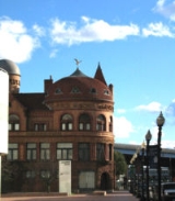
| 1 | Barnum Museum Barnum Museum The Barnum Museum is a museum in Bridgeport, Connecticut, USA with an extensive collection related to P. T. Barnum and the history of Bridgeport, Connecticut housed in an historic building on the National Register of Historic Places.- Construction :... |
 |
805 Main St. 41°10′32"N 73°11′18"W |
Downtown | ||
| 2 | Barnum/Palliser Historic District | Roughly bounded by Myrtle and Park Aves., Atlantic and Austin Sts. (both sides) 41°10′4"N 73°11′3"W |
South End | |||
| 3 | Bassickville Historic District Bassickville Historic District Bassickville Historic District is a historic district in Bridgeport, Connecticut that was listed on the National Register of Historic Places in 1987. It then included 38 contributing buildings.... |
20-122 Bassick, 667-777 Howard, and 1521-1523 Fairview Aves., and 50-1380 State St. 41°10′16"N 73°12′40"W |
West End - West Side | |||
| 4 | Beardsley Park |  |
1875 Noble Ave. 41°12′45"N 73°10′56"W |
North Bridgeport | ||
| 5 | BERKSHIRE NO. 7 Berkshire No. 7 Berkshire No. 7 is a wood and steel barge that was sunk in Bridgeport Harbor, in Bridgeport, Connecticut, listed on the National Register of Historic Places in 1978. It was built in 1935, which makes it unusually young for NRHP listing... |
Bridgeport Harbor 41°10′42"N 73°11′14"W |
Downtown | |||
| 6 | Bikur Cholim Synagogue | 1545 Iranistan Ave. 41°10′49"N 73°12′22"W |
West End - West Side | |||
| 7 | Peyton Randolph Bishop House | 135 Washington Ave. 41°10′38"N 73°11′54"W |
The Hollow | |||
| 8 | William D. Bishop Cottage Development Historic District | Cottage Pl. and Atlantic, Broad, Main and Whiting Sts. 41°10′5"N 73°11′14"W |
South End | |||
| 9 | Black Rock Gardens Historic District Black Rock Gardens Historic District Black Rock Gardens Historic District is a historic district in the Black Rock neighborhood of Bridgeport, Connecticut.It was listed on the National Register of Historic Places in 1990 and at that time included 12 contributing buildings.... |
Bounded by Fairfield St., Brewster St. and Nash Ln., including Rowsley and Haddon Sts. 41°9′27"N 73°13′30"W |
Black Rock | |||
| 10 | Black Rock Historic District Black Rock Historic District The Black Rock Historic District is a historic district in the Black Rock neighborhood of Bridgeport, Connecticut.It was listed on the National Register of Historic Places in 1979... |
Roughly bounded by Black Rock Harbor, Grovers Ave., Beacon and Prescott Sts. 41°9′11"N 73°13′17"W |
Black Rock | |||
| 11 | Bridgeport City Hall Bridgeport City Hall The old Bridgeport City Hall is located in Bridgeport, Connecticut. The building was built in 1854 as both the City Hall and the Fairfield County Courthouse and was added to the National Register of Historic Places on September 19, 1977... |
202 State St. 41°10′36"N 73°11′27"W |
Downtown | |||
| 12 | Bridgeport Downtown North Historic District | Roughly bounded by Congress, Water, Fairfield Ave., Elm, Golden Hill & Chapel Sts. 41°10′49"N 73°11′25"W |
Downtown | |||
| 13 | Bridgeport Downtown South Historic District Bridgeport Downtown South Historic District Bridgeport Downtown South Historic District is a historic district in Bridgeport, Connecticut that was listed on the National Register of Historic Places in 1987.... |
Roughly bounded by Elm, Cannon, Main, Gilbert, and Broad Sts. 41°10′37"N 73°11′30"W |
Downtown | |||
| 14 | Cassidy House | 691 Ellsworth St. 41°9′48"N 73°13′26"W |
Black Rock | |||
| 15 | Connecticut Railway and Lighting Company Car Barn Connecticut Railway and Lighting Company Car Barn The Connecticut Railway and Lighting Company Car Barn is located in Bridgeport, Connecticut. The building was built in 1910 and was added to the National Register of Historic Places on December 3, 1987... |
55 Congress St. 41°10′56"N 73°11′17"W |
Downtown | |||
| 16 | Deacon's Point Historic District | Roughly bounded by Seaview Ave. and Williston, Bunnell and Deacon Sts. 41°10′59"N 73°10′13"W |
East End | |||
| 17 | Division Street Historic District | Roughly bounded by State St., Iranistan, Black Rock and West Aves. 41°10′19"N 73°15′0"W |
Downtown and West End - West Side | |||
| 18 | Eagle's Nest | 282-284 Logan St. 41°10′43"N 73°9′37"W |
East End | |||
| 19 | East Bridgeport Historic District | Roughly bounded by RR tracks, Beach, Arctic, and Knowlton Sts. 41°11′14"N 73°11′9"W |
East Side | |||
| 20 | East Main Street Historic District | Bounded by Walters and Nichols Sts. from 371-377, 741-747, 388-394 and to 744 East Main Sts. 41°10′57"N 73°10′51"W |
East Side | |||
| 21 | Ein Jacob (Ayn Yacob) Synagogue | 746 (aka 748) Connecticut Ave. 41°10′50"N 73°9′51"W |
East End | |||
| 22 | ELMER S. DAILEY | Bridgeport Harbor 41°10′43"N 73°11′14"W |
Downtown | |||
| 23 | Fairfield County Courthouse Fairfield County Courthouse (Bridgeport, Connecticut) The Fairfield County Courthouse, also known as the Court of Common Pleas, in Bridgeport, Connecticut is a Richardsonian Romanesque brick building built in 1888... |
172 Golden Hill St. 41°10′50"N 73°11′28"W |
Downtown | |||
| 24 | Fairfield County Jail | 1106 North Ave. 41°11′25"N 73°12′7"W |
Brooklawn - St. Vincent | |||
| 25 | First Baptist Church | 126 Washington Ave. 41°10′35"N 73°11′53"W |
Downtown | |||
| 26 | Mary and Eliza Freeman Houses Mary and Eliza Freeman Houses The Mary and Eliza Freeman Houses are located in Bridgeport, Connecticut. The wood-framed, clapboard-covered, two-family houses were built in 1848 and were added to the National Register of Historic Places on February 22, 1999 as the last surviving houses of Little Liberia, a neighborhood settled... |
352-4 and 358-60 Main St. 41°10′11"N 73°11′12"W |
South End | |||
| 27 | Gateway Village Historic District | Roughly bounded by Waterman St., Connecticut Ave. and Alanson Ave. 41°9′27"N 73°13′30"W |
East End | |||
| 28 | Golden Hill Historic District | Roughly bounded by Congress St., Lyon Terr., Elm, and Harrison Sts. 41°10′52"N 73°11′36"W |
Downtown | |||
| 29 | Hotel Beach | 140 Fairfield Ave. 41°10′45"N 73°11′26"W |
Downtown | |||
| 30 | Lakeview Village Historic District | Roughly bounded by Essex St., Boston Ave., Colony St., Plymouth St. and Asylum St. 41°9′27"N 73°13′30"W |
North Bridgeport | |||
| 31 | Maplewood School Maplewood School The Maplewood School, also known as Grammar School No. 5, in Bridgeport, Connecticut, was built in 1893, and was designed by Longstaff & Hurd. The school was enlarged later. And an annex building designed by architect Joseph Northrup was added later... |
434 Maplewood Ave. 41°10′42"N 73°12′35"W |
West End - West Side | |||
| 32 | Marina Park Historic District | Marina Park, Park and Waldemere Aves. 41°9′52"N 73°11′30"W |
South End | |||
| 33 | Nathaniel Wheeler Memorial Fountain Nathaniel Wheeler Memorial Fountain Nathaniel Wheeler Memorial Fountain is located in Bridgeport, Connecticut at the intersection of Fairfield and Park avenues. The fountain was built in 1912–1913 and was added to the National Register of Historic Places on April 4, 1985... |
Park and Fairfield Aves. 41.1747°N 73.1987°W |
West End - West Side | Built in 1912--1913, the fountain consists of four elements: a central bronze figure of a mermaid holding aloft a lamp and rising out of a polished granite pool and three individually ornamented polished granite watering troughs at the angles of the triangular parcel of land raised above the street. The fountain was a mid-career work of maverick American sculptor Gutzon Borglum Gutzon Borglum Gutzon de la Mothe Borglum was an American artist and sculptor famous for creating the monumental presidents' heads at Mount Rushmore, South Dakota, the famous carving on Stone Mountain near Atlanta, as well as other public works of art.- Background :The son of Mormon Danish immigrants, Gutzon... . |
||
| 34 | Palace and Majestic Theaters | 1315-1357 Main St. 41°10′56"N 73°11′28"W |
Downtown | |||
| 35 | Park Apartments | 59 Rennell St. 41°9′39"N 73°11′40"W |
South End | |||
| 36 | Penfield Reef Light Penfield Reef Light Penfield Reef Lighthouse is a lighthouse in Connecticut,United States, on Penfield Reef at the south side of Black Rock Harbor entrance on the Long Island Sound, off the coast of Fairfield, Connecticut. Constructed in 1874, it was one of the last offshore masonry lights... house |
Long Island Sound Long Island Sound Long Island Sound is an estuary of the Atlantic Ocean, located in the United States between Connecticut to the north and Long Island, New York to the south. The mouth of the Connecticut River at Old Saybrook, Connecticut, empties into the sound. On its western end the sound is bounded by the Bronx... off Shoal Point 41°7′0"N 73°13′18"W |
Long Island Sound | |||
| 37 | Pequonnock River Railroad Bridge Pequonnock River Railroad Bridge The Pequonnock River Railroad Bridge is a railroad drawbridge over the Pequonnock River in Bridgeport, Connecticut. Owned by the State of Connecticut and maintained and operated by Metro-North Railroad, it is also referred to as Pequonnock River Bridge, PECK Bridge, and Undergrade Bridge 55.90... |
AMTRAK Right-of-way at Pequonnock River 41°10′59"N 73°11′11"W |
Downtown and East Side | |||
| 38 | David Perry House | 531 Lafayette St. 41°10′13"N 73°11′25"W |
Downtown | |||
| 39 | PRISCILLA DAILEY | Bridgeport Harbor 41°10′43"N 73°11′14"W |
Downtown | |||
| 40 | Railroad Avenue Industrial District | Roughly bounded by State and Cherry Sts., Fairfield and Wordin Aves. 41°4′40"N 73°12′49"W |
West End - West Side | |||
| 41 | Remington City Historic District | Roughly, Bond, Dover, and Remington Sts. and Palisade Ave., between Stewart and Tudor Sts. 41°11′53"N 73°9′56"W |
Boston Avenue - Mill Hill | |||
| 42 | Remington Village Historic District | Roughly, Willow and East Aves. between Boston and Barnum Aves. 41°11′38"N 73°9′36"W |
Boston Avenue - Mill Hill | |||
| 43 | St. John's Episcopal Church | 768 Fairfield Ave. 41°10′31"N 73°11′59"W |
West End - West Side | |||
| 44 | Seaside Institute Seaside Institute The Seaside Institute in Bridgeport, Connecticut is a Richardsonian Romanesque rock-faced granite, brick, brownstone and terracotta building designed by Warren R. Briggs and completed in 1887 at the corner of Lafayette and Atlantic avenues, not far from Seaside Park... |
299 Lafayette Ave. 41.1675°N 73.1883°W |
South End | A Richardsonian Romanesque Richardsonian Romanesque Richardsonian Romanesque is a style of Romanesque Revival architecture named after architect Henry Hobson Richardson, whose masterpiece is Trinity Church, Boston , designated a National Historic Landmark... rock-faced granite, brick, brownstone and terracotta building designed by Warren R. Briggs Warren R. Briggs Warren R. Briggs was an American architect who worked in Bridgeport, Connecticut. He was a "native of Boston" and trained at the Ecole des Beaux Arts in Paris. His work was greatly influenced by H. H... and completed in 1887, it was originally built for the use and benefit of the female employees of the Warner Brothers corset manufacturers (now Warnaco). |
||
| 45 | Seaside Park | Long Island Sound 41.159°N 73.202°W |
South End | |||
| 46 | Seaside Village Historic District | E. side of Iranistan Ave. between South St. and Burnham St. 41°9′59"N 73°11′56"W |
South End | |||
| 47 | Sterling Block-Bishop Arcade | 993-1005 Main St. 41°10′41"N 73°11′24"W |
Downtown | |||
| 48 | Sterling Hill Historic District Sterling Hill Historic District (Bridgeport, Connecticut) The Sterling Hill Historic District in Bridgeport, Connecticut is a historic district that was listed on the NRHP in 1992. The district is a two-block area of 43 urban residential structures dating as far back as 1821. Most of the buildings are from later in the 19th century when the neighborhood... |
Roughly bounded by Pequonnock St., Harral Ave., James St. and Washington Ave. 41°10′51"N 73°10′44"W |
The Hollow | |||
| 49 | Stratfield Historic District | CT 59 and U.S. 1 41°10′40"N 73°12′49"W |
Brooklawn - St. Vincent and West End - West Side | |||
| 50 | Tongue Point Light Tongue Point Light Tongue Point Light Lighthouse, also known as Bridgeport Breakwater or Bug Light, is a lighthouse on the west side of the Bridgeport Harbor entrance, in the city of Bridgeport, Connecticut in the United States. It was added to the National Register of Historic Places in 1990.-History:The lighthouse... house |
_light_(fairfield_county,_connecticut).jpg) |
Western side of Bridgeport Harbor at Tongue Point 41°9′58"N 73°10′42"W |
South End | ||
| 51 | United Congregational Church | 877 Park Ave. 41°10′30"N 73°12′0"W |
West End - West Side | |||
| 52 | United Illuminating Company Building | 1115-1119 Broad St. 41°10′41"N 73°11′31"W |
Downtown | |||
| 53 | US Post Office-Bridgeport Main | 120 Middle St. 41°10′50"N 73°11′20"W |
Downtown | |||
| 54 | West End Congregation--Achavath Achim Synagogue Achavath Achim Synagogue Achavath Achim Synagogue is located in Bridgeport, Connecticut. The building was built in 1926 and was added to the National Register of Historic Places on May 11, 1995 as West End Congregation--Achavath Achim Synagogue... |
725 Hancock Ave. 41°10′12"N 73°12′44"W |
West End - West Side | |||
| 55 | Wilmot Apartments Historic District | Junction of Connecticut and Wilmot Aves. 41°10′58"N 73°9′44"W |
East End |
See also
- History of Bridgeport, ConnecticutHistory of Bridgeport, ConnecticutThe history of Bridgeport, Connecticut was, in the late 17th and most of the 18th century, one of land acquisitions from the native inhabitants, farming and fishing. From the mid-18th century to the mid-19th century, Bridgeport's history was one of shipbuilding, whaling and rapid growth...
- National Register of Historic Places listings in Fairfield County, Connecticut
- National Register of Historic Places listings in Stamford, ConnecticutNational Register of Historic Places listings in Stamford, ConnecticutThis is a list of the properties and historic districts in Stamford, Connecticut that are listed on the National Register of Historic Places. The locations of National Register properties and districts for which the latitude and longitude coordinates are included below, may be seen in a Google...
- National Register of Historic Places listings in Greenwich, ConnecticutNational Register of Historic Places listings in Greenwich, ConnecticutThis is a list of the National Register of Historic Places listings in Greenwich, Connecticut.This is intended to be a complete list of the properties and districts on the National Register of Historic Places in Greenwich...