

National Port Authority, Liberia
Encyclopedia
The National Port Authority of the Republic of Liberia (NPA) is the government agency
responsible for the governance and operation of the port
s of Liberia
. Established in 1967, its main office is on Bushrod Island
in Monrovia
and the current Managing Director of the NPA is Hon. Matilda Parker.
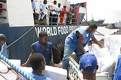
On March 2010, the Freeport of Monrovia became ISPS Compliant (with no conditions) and moved from Security Level 2 to Security Level 1 in July 2010. The Freeport of Monrovia awarded Operations Contract to APM Terminal to handle port operations, which includes container handling, cargo handling, and marine.
As of 2011, a One-Stop Shop has been established at the Port to make it expedite Shipping and Clearing Procedures. Ministry of Finance, Ministry of Commerce, and Central Bank have set up sub stations at the Port to expedite the process.
, the Port of Buchanan
, the Port of Greenville
and the Port of Harper
.
The Freeport of Monrovia is the largest in the Authority's Network. The United States Military built the port during World War II
for strategic purposes. It handles most of the country's imported cargoes. Two breakwaters, 2,359m and 2,200m long, protect the harbour, enclosing a basin of 300 hectares of protected water. The general cargo berth
, (the main pier), consists of an opened piled, 610m long by 11m wide marginal wharf with a reinforced concrete deck. The main wharf serves 2nd and 3rd generation coastal and mainline vessel.
The Port of Buchanan is located 170miles South-east of Monrovia. The Liberia-American Swedish Company (LAMCO), a joint venture
company, constructed the port in 1960 for the export of iron ore deposits of the Nimba Range. Two break waters, 1,890m and 590m long to protect the harbour. Inside the basin, a 225m long ore-loading quay is located to the deeper section of the harbour basin
with a water depth of 12.95m below chart datum. Adjacent to the loading quay, a waiting berth for ore carrier is available. On the inner side of the secondary breakwater, a commercial quay 334m long is located with an available water depth of 10.15m below chart datum. The access channel to the port provides ship a water depth of 14.95m below chart datum and a channel width between the breakwaters of 210m.
The Port of Greenville is also located in the South-eastern region of the country, Sinoe County
, about 421 miles from the Freeport of Monrovia. A 400m long breakwater protects the harbour. There are two quays (70m and 180m long respectively) on the inner side of the breakwater for berthing facilities, with an existing water depth of 6m below chart datum. The port was rehabilatated in the early eighties with loan from the German Development Fund. The port functions mainly as an outlet for the timber industry.
The Port of Harper is situated in the South-eastern region of Liberia, Maryland County, near the border with the Ivory Coast, about 476 miles from the Freeport of Monrovia. The Port was constructed in 1959, on the rocky Russwurn Island, by connecting the island to the mainland with a causeway and by constructing a 150m long breakwater off the Russwurn Island. A 100m long reinforced concrete pier
with an available water depth of 5.50m provides berthing facilities. The port serves the timber industry of the South-eastern hinterland
.
 The largest port in the authority's network, Freeport of Monrovia was built by the United States
military during World War II for strategic purposes. It handles most of the authority's imported cargo, some of which are transshipped to other Liberian ports and to third countries. The Freeport of Monrovia consists of an artificial harbor formed by two-rock breakwater approximately 2,300 meters out into the open sea, which encompass some 300 hectares of protected water. The coastline between the breakwater is dredged to accommodate ocean going vessel and ore carriers (up to 100,000 dwt) and a marginal wharf of 610 meters long is capable of berthing 3-4 ships according to their size. The port is connected with Monrovia by an access road(four lanes approximately 1.5 kilometers long with two connecting bridges over the Mesurraddo River of which one is out of use.
From the seaside, the vessel enter the harbor basin
through an entrance channel approximately 2,000 m long and 180 m wide. The central part of the port area is occupied by two iron ore companies (NIOC and Bong Mines) that previously operated their own facilities but have since folded up operations. A crude oil mooring
station is located between the iron ore piers.
The general cargo wharf located south of this central area, is entirely operated by NPA which provides all onshore services and facilities to the users. The former Liberia Mining Company (LMC) pier which is not operational except for use by local fishing trawlers is situated at the northern end of the General Cargo wharf.
There is 500 m long oil jetty for refined products situated alongside the southern breakwater approximately 450 m off the coastline and it is connected to the tank farms by pipelines. The back of the Freeport is occupied by the port warehouses and shed s and also by private bonded warehouses.
The Harbor is protected by two breakwaters, 1890 and 590 long respectively. Inside the basin, a 255 meters long ore loading quay is located adjacent to the deeper section of the harbor basin, providing a water depth of 12.95m below chart datum. Adjacent to the loading quay, a waiting berth for ore carriers is available. On the inner side of secondary breakwater, a commercial quay, 334 meters long is located with available water depth of 9.5 m.
Latitude: 5° 51' 29" N
Longitude: 10° 3' 15" W
UN/LOCODE: LRUCN
Port Type: Seaport
Port Size: Small
Latitude: 4° 22' 18" N
Longitude: 7° 43' 25" W
UN/LOCODE: LRHAR
Port Type: Pier, Jetty or Wharf
Port Size: Small
It was rehabilitated in the early 1980s with funds from the German Development Fund. Prior to the civil crisis, the port functioned as an outlet for the log and sawn timber industries. It had an annual pre-war throughput of 281,860.5 metric tons.
Latitude: 4° 59' 22" N
Longitude: 9° 2' 30" W
UN/LOCODE: LRGRE
Port Type: Harbor
Port Size: Small
Government agency
A government or state agency is a permanent or semi-permanent organization in the machinery of government that is responsible for the oversight and administration of specific functions, such as an intelligence agency. There is a notable variety of agency types...
responsible for the governance and operation of the port
Port
A port is a location on a coast or shore containing one or more harbors where ships can dock and transfer people or cargo to or from land....
s of Liberia
Liberia
Liberia , officially the Republic of Liberia, is a country in West Africa. It is bordered by Sierra Leone on the west, Guinea on the north and Côte d'Ivoire on the east. Liberia's coastline is composed of mostly mangrove forests while the more sparsely populated inland consists of forests that open...
. Established in 1967, its main office is on Bushrod Island
Bushrod Island
Bushrod Island is an island near Monrovia, Liberia surrounded by the Atlantic Ocean, the Saint Paul River and the Mesurado River. It contains the Freeport of Monrovia, the major national port of Liberia and a variety of businesses. It also contains numerous residential areas and government buildings...
in Monrovia
Monrovia
Monrovia is the capital city of the West African nation of Liberia. Located on the Atlantic Coast at Cape Mesurado, it lies geographically within Montserrado County, but is administered separately...
and the current Managing Director of the NPA is Hon. Matilda Parker.
On March 2010, the Freeport of Monrovia became ISPS Compliant (with no conditions) and moved from Security Level 2 to Security Level 1 in July 2010. The Freeport of Monrovia awarded Operations Contract to APM Terminal to handle port operations, which includes container handling, cargo handling, and marine.
As of 2011, a One-Stop Shop has been established at the Port to make it expedite Shipping and Clearing Procedures. Ministry of Finance, Ministry of Commerce, and Central Bank have set up sub stations at the Port to expedite the process.
Establishment
An act of Legislature established the National Port Authority in 1967 (amended in 1970) as a state-owned enterprise to manage, plan and develop all ports in Liberia. The Authority manages four ports, namely, the Freeport of MonroviaMonrovia
Monrovia is the capital city of the West African nation of Liberia. Located on the Atlantic Coast at Cape Mesurado, it lies geographically within Montserrado County, but is administered separately...
, the Port of Buchanan
Buchanan, Liberia
Buchanan is the third largest city in Liberia, lying on Waterhouse Bay, part of the Atlantic Ocean. It is referred to as Gbezohn in the local Bassa language. As of the 2008 census, Buchanan has a population of 34,270. Of this, 16,984 were male and 17,286 female....
, the Port of Greenville
Greenville, Liberia
Greenville, also known as Sinoe, is the capital of Sinoe County in southeastern Liberia and lies on a lagoon near the Sinoe River and the Atlantic Ocean...
and the Port of Harper
Harper, Liberia
Harper, situated on Cape Palmas, is the capital of Maryland County in Liberia. It is a coastal town situated between the Atlantic Ocean and the Hoffman River. Harper is Liberia's 11th largest town, with a population of 17,837....
.
The Freeport of Monrovia is the largest in the Authority's Network. The United States Military built the port during World War II
World War II
World War II, or the Second World War , was a global conflict lasting from 1939 to 1945, involving most of the world's nations—including all of the great powers—eventually forming two opposing military alliances: the Allies and the Axis...
for strategic purposes. It handles most of the country's imported cargoes. Two breakwaters, 2,359m and 2,200m long, protect the harbour, enclosing a basin of 300 hectares of protected water. The general cargo berth
Berth
Berth may refer to:*Berth *Berth *Berth , an album by The UsedBerthing may refer to:*The placement of a spacecraft into a berthing mechanism through the use of a robotic arm*A cabin on a ship...
, (the main pier), consists of an opened piled, 610m long by 11m wide marginal wharf with a reinforced concrete deck. The main wharf serves 2nd and 3rd generation coastal and mainline vessel.
The Port of Buchanan is located 170miles South-east of Monrovia. The Liberia-American Swedish Company (LAMCO), a joint venture
Joint venture
A joint venture is a business agreement in which parties agree to develop, for a finite time, a new entity and new assets by contributing equity. They exercise control over the enterprise and consequently share revenues, expenses and assets...
company, constructed the port in 1960 for the export of iron ore deposits of the Nimba Range. Two break waters, 1,890m and 590m long to protect the harbour. Inside the basin, a 225m long ore-loading quay is located to the deeper section of the harbour basin
Basin
Basin may refer to:* Basin , a poem about Charlemagne's childhood* basin , the area of a drydock which can be flooded and drained* basin of attraction , an area of a nonlinear system with an attractor...
with a water depth of 12.95m below chart datum. Adjacent to the loading quay, a waiting berth for ore carrier is available. On the inner side of the secondary breakwater, a commercial quay 334m long is located with an available water depth of 10.15m below chart datum. The access channel to the port provides ship a water depth of 14.95m below chart datum and a channel width between the breakwaters of 210m.
The Port of Greenville is also located in the South-eastern region of the country, Sinoe County
Sinoe County
Sinoe is one of Liberia's 15 counties and it has 17 districts. Greenville is the county's capital.As of the 2008 Census, it had a population of 104,932, making it one of the least populous counties in Liberia....
, about 421 miles from the Freeport of Monrovia. A 400m long breakwater protects the harbour. There are two quays (70m and 180m long respectively) on the inner side of the breakwater for berthing facilities, with an existing water depth of 6m below chart datum. The port was rehabilatated in the early eighties with loan from the German Development Fund. The port functions mainly as an outlet for the timber industry.
The Port of Harper is situated in the South-eastern region of Liberia, Maryland County, near the border with the Ivory Coast, about 476 miles from the Freeport of Monrovia. The Port was constructed in 1959, on the rocky Russwurn Island, by connecting the island to the mainland with a causeway and by constructing a 150m long breakwater off the Russwurn Island. A 100m long reinforced concrete pier
Pier
A pier is a raised structure, including bridge and building supports and walkways, over water, typically supported by widely spread piles or pillars...
with an available water depth of 5.50m provides berthing facilities. The port serves the timber industry of the South-eastern hinterland
Hinterland
The hinterland is the land or district behind a coast or the shoreline of a river. Specifically, by the doctrine of the hinterland, the word is applied to the inland region lying behind a port, claimed by the state that owns the coast. The area from which products are delivered to a port for...
.
Port of Monrovia
United States
The United States of America is a federal constitutional republic comprising fifty states and a federal district...
military during World War II for strategic purposes. It handles most of the authority's imported cargo, some of which are transshipped to other Liberian ports and to third countries. The Freeport of Monrovia consists of an artificial harbor formed by two-rock breakwater approximately 2,300 meters out into the open sea, which encompass some 300 hectares of protected water. The coastline between the breakwater is dredged to accommodate ocean going vessel and ore carriers (up to 100,000 dwt) and a marginal wharf of 610 meters long is capable of berthing 3-4 ships according to their size. The port is connected with Monrovia by an access road(four lanes approximately 1.5 kilometers long with two connecting bridges over the Mesurraddo River of which one is out of use.
From the seaside, the vessel enter the harbor basin
Basin
Basin may refer to:* Basin , a poem about Charlemagne's childhood* basin , the area of a drydock which can be flooded and drained* basin of attraction , an area of a nonlinear system with an attractor...
through an entrance channel approximately 2,000 m long and 180 m wide. The central part of the port area is occupied by two iron ore companies (NIOC and Bong Mines) that previously operated their own facilities but have since folded up operations. A crude oil mooring
Mooring
Mooring may refer to:* Mooring , any device used to hold secure an object by means of cables, anchors, or lines* Mooring mast, a structure designed to hold airships and blimps securely in the open when they are not in flight....
station is located between the iron ore piers.
The general cargo wharf located south of this central area, is entirely operated by NPA which provides all onshore services and facilities to the users. The former Liberia Mining Company (LMC) pier which is not operational except for use by local fishing trawlers is situated at the northern end of the General Cargo wharf.
There is 500 m long oil jetty for refined products situated alongside the southern breakwater approximately 450 m off the coastline and it is connected to the tank farms by pipelines. The back of the Freeport is occupied by the port warehouses and shed s and also by private bonded warehouses.
Port of Buchanan
The Port of Buchanan is located some 272 kilometers South-East of Monrovia. It constructed in 1960 by the Liberian-American Swedish Mining Corporation (LAMCO), a joint venture company, to export the iron ore deposits of the Nimba range.The Harbor is protected by two breakwaters, 1890 and 590 long respectively. Inside the basin, a 255 meters long ore loading quay is located adjacent to the deeper section of the harbor basin, providing a water depth of 12.95m below chart datum. Adjacent to the loading quay, a waiting berth for ore carriers is available. On the inner side of secondary breakwater, a commercial quay, 334 meters long is located with available water depth of 9.5 m.
Latitude: 5° 51' 29" N
Longitude: 10° 3' 15" W
UN/LOCODE: LRUCN
Port Type: Seaport
Port Size: Small
Port of Harper
It was constructed by connecting the Island to the mainland with a causeway and constructing a 150 meter long breakwater off Russwurm Island. Berthing facilities are provided by a 100 meter long reinforced concrete pier with available water depth of 5.5 meters on both sides. Its activities are centered on the exports of logs and sawn timber from the southeastern hinterland of the country. It has the potential to handle traffic that will derive from the reactivation of the palm oil sector.Latitude: 4° 22' 18" N
Longitude: 7° 43' 25" W
UN/LOCODE: LRHAR
Port Type: Pier, Jetty or Wharf
Port Size: Small
Port of Greenville
The Port of Greenville is located in the south-eastern region of the country, about 673 kilometers from the Freeport of Monrovia. The harbor is protected by a 400 meter long two quay breakwater on the inner side. There are two berthing facilities 70 and 80 meters long respectively, with existing water depth of 6 meters below chart datum.It was rehabilitated in the early 1980s with funds from the German Development Fund. Prior to the civil crisis, the port functioned as an outlet for the log and sawn timber industries. It had an annual pre-war throughput of 281,860.5 metric tons.
Latitude: 4° 59' 22" N
Longitude: 9° 2' 30" W
UN/LOCODE: LRGRE
Port Type: Harbor
Port Size: Small