

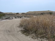
Napeague State Park
Encyclopedia
Amagansett, New York
Amagansett is a census-designated place that roughly corresponds to the hamlet by the same name in the town of East Hampton in Suffolk County, New York on the South Shore of Long Island. As of the United States 2000 Census, the CDP population was 1,067. Amagansett hamlet was founded in 1680.The...
and Montauk, New York
Montauk, New York
Montauk [ˈmɒntɒk] is a census-designated place that roughly corresponds to the hamlet with the same name located in the town of East Hampton in Suffolk County, New York, United States on the South Shore of Long Island. As of the United States 2000 Census, the CDP population was 3,851 as of 2000...
, in the United States
United States
The United States of America is a federal constitutional republic comprising fifty states and a federal district...
. It stretches from the Atlantic Ocean
Atlantic Ocean
The Atlantic Ocean is the second-largest of the world's oceanic divisions. With a total area of about , it covers approximately 20% of the Earth's surface and about 26% of its water surface area...
across the entire narrow width of the South Fork of Long Island to Gardiners Bay
Gardiners Bay
Gardiners Bay is a small arm of the Atlantic Ocean, approximately 10 mi long and 8 mi wide in the U.S. state of New York between the two flukelike peninsulas at the eastern end of Long Island...
/Block Island Sound
Block Island Sound
Block Island Sound is a strait in the open Atlantic Ocean, approximately wide, separating Block Island from the coast of Rhode Island in the United States...
on the north.
On the edge of it is the hamlet of Napeague, New York
Napeague, New York
Napeague is a census-designated place that roughly corresponds to the hamlet with the same name in the town of East Hampton in Suffolk County, New York, United States...
.
The land was initially purchased by the Nature Conservancy and conveyed to New York State in 1986http://www.nynjctbotany.org/lgtofc/napeague.html. It consists mostly of wetlands in area where waves overwashed Long Island
Long Island
Long Island is an island located in the southeast part of the U.S. state of New York, just east of Manhattan. Stretching northeast into the Atlantic Ocean, Long Island contains four counties, two of which are boroughs of New York City , and two of which are mainly suburban...
during the Great Hurricane of 1938.
There is virtually no infrastructure or permitted camping at the park, which is administered by nearby Hither Hills State Park
Hither Hills State Park
Hither Hills State Park is a state park located on the southern shore near the eastern tip of Long Island in Suffolk County, New York in the USA.The park is located on the South Fork of Long Island at Napeague, New York...
. Its most distinguishing natural feature—a pristine Atlantic Ocean
Atlantic Ocean
The Atlantic Ocean is the second-largest of the world's oceanic divisions. With a total area of about , it covers approximately 20% of the Earth's surface and about 26% of its water surface area...
beach—is usually closed during the summer because the endangered Piping Plover
Piping Plover
The Piping Plover is a small sand-colored, sparrow-sized shorebird that nests and feeds along coastal sand and gravel beaches in North America. The adult has yellow-orange legs, a black band across the forehead from eye to eye, and a black ring around the neck...
nests near the beach.
The landmark of the park is the huge abandoned Smith Meal fish factory in an area on Gardiners Bay called Promised Land. A controversy rages after Cross Sound Ferry
Cross Sound Ferry
Cross Sound Ferry is a passenger and road vehicle ferry service operating between New London, Connecticut and Orient, Long Island, New York. The service is privately owned and operated by Cross Sound Ferry Services, Inc., headquartered in New London...
said it wanted to start ferry from the Promised Land terminal across Long Island Sound
Long Island Sound
Long Island Sound is an estuary of the Atlantic Ocean, located in the United States between Connecticut to the north and Long Island, New York to the south. The mouth of the Connecticut River at Old Saybrook, Connecticut, empties into the sound. On its western end the sound is bounded by the Bronx...
to New London, Connecticut
New London, Connecticut
New London is a seaport city and a port of entry on the northeast coast of the United States.It is located at the mouth of the Thames River in New London County, southeastern Connecticut....
. There is currently no service connecting the South Fork of Long Island to Connecticut
Connecticut
Connecticut is a state in the New England region of the northeastern United States. It is bordered by Rhode Island to the east, Massachusetts to the north, and the state of New York to the west and the south .Connecticut is named for the Connecticut River, the major U.S. river that approximately...
and its Foxwoods and Mohegan Sun
Mohegan Sun
Mohegan Sun, located in Uncasville, Connecticut, is the second largest casino in the United States with of gaming space. It is located on along the banks of the Thames River. It is at the heart of the scenic foothills of southeastern Connecticut, where 60 percent of the state's tourism is...
casinos. The only ferry service on the east end of Long Island goes from Orient Point
Orient, New York
Orient is a census-designated place in Suffolk County, New York, United States. The CDP's population was 709 at the 2000 census.Orient and Orient Point are used almost interchangeably...
on the North Fork and North Fork residents said this creates traffic jams on its two-lane roads. East Hampton (town), New York
East Hampton (town), New York
The Town of East Hampton is located in southeastern Suffolk County, New York, at the eastern end of the South Shore of Long Island. It is the easternmost town in the state of New York...
has so far successfully fought any proposal to start ferry service there.