

Myelat
Encyclopedia
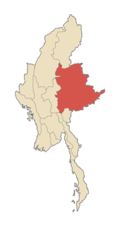
Myelat is a region of the southern Shan State
Shan State
Shan State is a state of Burma . Shan State borders China to the north, Laos to the east, and Thailand to the south, and five administrative divisions of Burma in the west. Largest of the 14 administrative divisions by land area, Shan State covers 155,800 km², almost a quarter of the total...
of Burma. Originally this would have comprised the smaller states typically ruled by "Myosas" (chief of town) or "Ngwegunhmus" (silver revenue chief), buffering the plains of Burma and the ethnic Shan states further east. The exact composition of the states within the Myelat area has changed through history, dependent on vagaries of local power politics as well as approval by the Burmese court. At times, states have been combined, at other times, they have been split up. At the time of the British annexation of the Shan states, the following sixteen states were recognized to be within the Myelat region: Hsamonghkam
Hsamonghkam
Hsamonghkam was a Shan state in the Myelat region of Burma. Its capital was Aungban.Hsamonghkam was established before 1700 CE. During the 18th and 19th centuries it was a tributary of Burma. In 1886, following the fall of the Konbaung dynasty, it submitted to British rule...
, Kyawkku Hsiwan, Kyong
Kyong
Kyong was a Shan state in the Myelat region of what is today Burma....
, Loi-ai
Loi-ai
Loi-ai was a Shan state in the Myelat region of what is today Burma....
, Loilong
Loilong
Loilong was a Shan state in the Myelat region of what is today Burma. Its capital was Pinlaung. It had a large Pa-O population....
, Loimaw
Loimaw
Loimaw was a Shan state in the Myelat region of what is today Burma. Its capital was Minywa. Its population was mostly Pa-O....
, Maw
Maw (state)
Maw was a Shan state in the Myelat region of what is today Burma. Its capital was Myogyi. Its population was mostly Danu....
, Mawnang
Mawnang
Mawnang was a Shan state in the Myelat region of what is today Burma. Its population was mostly Taungyo....
, Mawson
Mawson (state)
Mawson was a Shan state in the Myelat region of what is today Burma. Its capital was Myogyi. Its population consisted of Danu, Pa-O, and Taungyo....
, Namhkai
Namhkai
Namhkai was a Namhkai was a Namhkai was a [[Shan people|Shan] state in the [[Myelat]] region of what is today [[Burma]]. Its capital was [[Paw-in]]. Its population was almost entirely [[Pa-O]]....
, Namhkom, Namtok
Namtok
Namtok is a village and a former Shan state in the Myelat region of what is today Burma. It was very small, having an area of only . Today it is located in Langhko Township in Langhko District just to the northeast of Langhko town....
, Pangmi
Pangmi
Pangmi was a Shan state in the Myelat region of what is today Burma. It was very small, having an area of only , and was almost entirely enclosed by Hsamonghkam. Its population was mostly Danu and Pa-O....
, Pangtara
Pindaya Township
Pindaya Township is a township of Taunggyi District in the Shan State of Myanmar. The principal town is Pindaya....
, Poila
Poila
Poila was a Shan state in the Myelat region of what is today Burma. Its population was mostly Taungyo, with the remainder being Danu and Pa-O....
, and Yengan
Ywangan Township
Ywangan Township is a township of Taunggyi District in the Shan State of Myanmar. The principal town is Ywangan....
. The total area of these states is approximately 3900 square miles (10,101 km²).
The area is hemmed in on the north by the state of Lawksawk, on the east by the states of Yawnghwe, Wanyin and Hsatung, and on the south by Mong Pai.
In 1897, the population was recorded as 107,500, the majority being of the Taungthu or Pa-O
Pa-O
The Pa-Oh form an ethnic group in Burma, comprising approximately 600,000. The Pa-Oh form the second largest ethnic group in Shan State, and are classified as part of the "Shan National Race" by the government, although they are believed to be of Tibeto-Burman stock, and are ethnolinguistically...
(42933), followed by Danu (29713), Taungyo (13906), Shan (6572), and a smaller number of other races.
The name Myelat could be interpreted as "unoccupied land" in Burmese, however the land has been populated for quite some time. The name could also be interpreted as "middle earth", implying a buffer zone, or "fair earth", depending on a variation of the spelling. All central Myelat and great parts of the northern and southern portions consist of rolling grass
Grass
Grasses, or more technically graminoids, are monocotyledonous, usually herbaceous plants with narrow leaves growing from the base. They include the "true grasses", of the Poaceae family, as well as the sedges and the rushes . The true grasses include cereals, bamboo and the grasses of lawns ...
y downs bare of jungle
Jungle
A Jungle is an area of land in the tropics overgrown with dense vegetation.The word jungle originates from the Sanskrit word jangala which referred to uncultivated land. Although the Sanskrit word refers to "dry land", it has been suggested that an Anglo-Indian interpretation led to its...
. The area is productive in agriculture, crops grown include potatoes, corn, wheat, cabbage, cauliflower, oranges, coffee, as well as rice. Visitors to the area immediately notice the red earth of the countryside, due to high iron oxide content of the soil.
The term "Myelat" is still in common use today, although the old political and administrative distinctions no longer apply.