

Murerplan
Encyclopedia
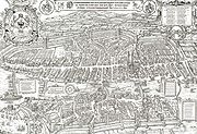
Map
A map is a visual representation of an area—a symbolic depiction highlighting relationships between elements of that space such as objects, regions, and themes....
of Zürich
Zürich
Zurich is the largest city in Switzerland and the capital of the canton of Zurich. It is located in central Switzerland at the northwestern tip of Lake Zurich...
, printed in 1576 by Jos Murer (1530-1580).
It was combined from six pearwood plates measuring 45 cm squared each. A smaller extra plate was made for the Grossmünster
Grossmünster
The Grossmünster is a Romanesque-style church in Zurich, Switzerland. It is one of the three major churches in the city . The core of the present building near the banks of the Limmat River was constructed on the site of a Carolingian church, which was, according to legend, originally commissioned...
, which would otherwise have been divided between four plates.
The original plates have not been preserved. The plates of a second edition of 1610 survive.
Description
The map is entitled- Der uralten wytbekannten Statt Zurych gestalt und gelaegenhait / wie sy zuo diser zyt in waesen / ufgerissen und in grund gelegt / durch Josen Murer / und durch Christoffel Froschaower / zuo Eeren dem Vatterland getruckt / Im M.D.LXXVI. Jar.
- "The aspect and situation of the ancient and famous town of Zurich / as it has been at this time / drawn and etched / by Jos Murer / and by Christoph Froschauer / printed for the glory of the nation / AD 1576"
The plan is extremely detailed, showing the aspect of every house, and is a unique historical source for the condition of the city in the 16th century. Zurich had essentially preserved its medieval (13th-century) aspect until that time (except for the frequent replacement of earlier wooden buildings by stone houses), and major expansions and city planning began only in the 17th century, with the addition of rampart
Defensive wall
A defensive wall is a fortification used to protect a city or settlement from potential aggressors. In ancient to modern times, they were used to enclose settlements...
s during the Thirty Years' War
Thirty Years' War
The Thirty Years' War was fought primarily in what is now Germany, and at various points involved most countries in Europe. It was one of the most destructive conflicts in European history....
.
The plan looks east over the city (north to the left), with the moat at the bottom of the plan corresponding to the present Bahnhofstrasse
Bahnhofstrasse, Zürich
Bahnhofstrasse is Zurich's main downtown street and one of the world's most expensive and exclusive shopping avenues. In 2010 a study has named the Bahnhofstrasse the third most expensive street for retail property in Europe, and the fifth most expensive worldwide. It came into exsistence when the...
, with the Rennweg gate, the main entry to the city. The bottom left corner shows the confluence of the Sihl
Sihl
The Sihl is a river of Switzerland. It rises at Drusberg in the Canton of Schwyz. It passes through the Sihlsee near Einsiedeln, and then enters the Canton of Zurich, flowing through the Sihl valley at the foot of the Albis, passing the Sihlwald, the largest remaining deciduous forest of the Swiss...
and Limmat
Limmat
The Limmat is a river in Switzerland. It is the continuation of the Linth river, known as Limmat from the point of effluence from Lake Zurich, in the city of Zurich. From Zurich it flows in a northwesterly direction, after 35 km reaching the river Aare...
rivers, the location of the present Zurich Hauptbahnhof.