
Mullum Mullum Creek Trail
Encyclopedia
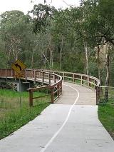
The Mullum Mullum Creek Trail is a shared use path for cyclists
and pedestrian
s, which follows Mullum Mullum Creek in the outer eastern suburbs in Melbourne
, Victoria
, Australia
.
The path is currently split into two sections, which will be linked to form one continuous trail from Templestowe to Croydon. Until this link is constructed, the two sections of the path between the end of the Yarra River Trail in Templestowe and Tindals Road in Donvale is the lower section, while the section between the end of the Koonung Creek Trail
in Donvale and Highland Avenue in Croydon is the upper section. The missing section is currently being constructed in two parts. The section between Tindals Road and Park Road in Donvale is currently under construction and was set to open in 2009, but as of December 2011 it is yet to be completed. The section between Park Road and the end of the Koonung Creek Trail in Donvale will be constructed in the future, with a detail planning study having been completed.
, which initially runs on-road along Suda Avenue and Samuel Street. The trail then heads under the tunnel and takes an immediate right turn west towards Eastland Shopping Centre
. A road crossing at Warrandyte Road and a tunnel under Ringwood Street sends you to the end of the EastLink Trail
. Continuing under the EastLink
onramps leads you under Deep Creek Road and into Yarran Dheran
. The path continues north west past sensitive flora and fauna by the concrete path mixed with a series of timber bridges and boardwalks. An at-level crossing with Quarry Road is confronted before continuing west. The track ends at a currently unsigned future extension of the Mullum Mullum Creek Trail 80m west of Beckett Road. At this point, the path seamlessly becomes the Koonung Creek Trail
, which takes users towards Doncaster
and eventually the Melbourne CBD
along the Eastern Freeway. Refer also to Mullum Mullum Creek
and Mullum Mullum Creek Park
Current progress of trail works: So far, heading north from Park Rd. a small carpark, an ashphalted 2metre wide trail(~1km) and 2 bridges have been completed but the works stop short about 700m from Tindals Rd. (NB. There is no access through to Tindals Rd.)
Foundations works on the southern side of Park Rd. for the trail bridge over the Mullum Mullum Creek also appear under construction.
After 1.1 km the path opens up into a more open area and meets the Greengully Trail
that enters from the left (south). The intersection is badly signed. Continue past large open areas on the right (east) where Kangaroos
/Wallabies
can be seen on a regular basis, just 20 km from the Melbourne CBD
.
The trail finally ends at the confluence of the Mullum Mullum Creek and the Yarra River
in Templestowe
. A lookout surveys the spot. The Yarra River Trail starts here.
. The north eastern end of the upper section finishes at Cherry Tree Grv. From Cherry Grv, a 2.7 km road section, via Croydon station
, can be used to reach the Tarralla Creek Trail
. A Maroondah Council project "Lake to Creek Link Project" will, once completed, improve the link to Ringwood Lake and the Belgrave Rail Trail
beyond.
The northern end of the lower section connects to the Yarra River Trail. The path also connects to the Greengully Trail
1.2 km south of the Yarra. The southern end of the lower section terminates at Tindals Rd.
Upper: West end at 37.804200°S 145.204411°E.
East end at 37.785142°S 145.264044°E.
Lower: North end at 37.738386°S 145.161994°E.
South end at 37.775679°S 145.190680°E.
Cycling
Cycling, also called bicycling or biking, is the use of bicycles for transport, recreation, or for sport. Persons engaged in cycling are cyclists or bicyclists...
and pedestrian
Pedestrian
A pedestrian is a person traveling on foot, whether walking or running. In some communities, those traveling using roller skates or skateboards are also considered to be pedestrians. In modern times, the term mostly refers to someone walking on a road or footpath, but this was not the case...
s, which follows Mullum Mullum Creek in the outer eastern suburbs in Melbourne
Melbourne
Melbourne is the capital and most populous city in the state of Victoria, and the second most populous city in Australia. The Melbourne City Centre is the hub of the greater metropolitan area and the Census statistical division—of which "Melbourne" is the common name. As of June 2009, the greater...
, Victoria
Victoria (Australia)
Victoria is the second most populous state in Australia. Geographically the smallest mainland state, Victoria is bordered by New South Wales, South Australia, and Tasmania on Boundary Islet to the north, west and south respectively....
, Australia
Australia
Australia , officially the Commonwealth of Australia, is a country in the Southern Hemisphere comprising the mainland of the Australian continent, the island of Tasmania, and numerous smaller islands in the Indian and Pacific Oceans. It is the world's sixth-largest country by total area...
.
The path is currently split into two sections, which will be linked to form one continuous trail from Templestowe to Croydon. Until this link is constructed, the two sections of the path between the end of the Yarra River Trail in Templestowe and Tindals Road in Donvale is the lower section, while the section between the end of the Koonung Creek Trail
Koonung Creek Trail
The Koonung Creek Trail is a shared use path for cyclists and pedestrians, which follows Koonung Creek in the eastern suburbs of Melbourne, Victoria, Australia...
in Donvale and Highland Avenue in Croydon is the upper section. The missing section is currently being constructed in two parts. The section between Tindals Road and Park Road in Donvale is currently under construction and was set to open in 2009, but as of December 2011 it is yet to be completed. The section between Park Road and the end of the Koonung Creek Trail in Donvale will be constructed in the future, with a detail planning study having been completed.
Upper section
The upper section starts in the east at the end of Highland Ave. The path heads in a south westerly direction, with at-level road crossing at Kalinda Road, Oban Road, and Oliver Street. Before the tunnel under the Ringwood Bypass, there is a turnoff to the Belgrave Rail TrailBelgrave Rail Trail
The Ringwood - Belgrave Rail Trail is a shared-use path for cyclists and pedestrians, which follows the Belgrave railway line from the Mullum Mullum Creek Trail in Ringwood to Belgrave railway station in Belgrave, in the outer eastern suburbs of Melbourne, Victoria, Australia.This trail is known to...
, which initially runs on-road along Suda Avenue and Samuel Street. The trail then heads under the tunnel and takes an immediate right turn west towards Eastland Shopping Centre
Eastland Shopping Centre
Eastland Shopping Centre is a large shopping centre located in the outer eastern suburb of Ringwood, in Melbourne, Victoria, Australia, which first opened on 31 October 1967....
. A road crossing at Warrandyte Road and a tunnel under Ringwood Street sends you to the end of the EastLink Trail
EastLink Trail
The EastLink Trail is a shared use path for cyclists and pedestrians, which follows the EastLink tollway for most of its length from Ringwood to Dandenong, in the outer eastern suburbs of Melbourne, Victoria, Australia.-Following the path:...
. Continuing under the EastLink
EastLink, Melbourne
EastLink is a A$2.5 billion tolled freeway linking a large area through the eastern and south-eastern suburbs of Melbourne, Australia. It is a part of Melbourne's Metropolitan Ring Road project....
onramps leads you under Deep Creek Road and into Yarran Dheran
Yarran Dheran
Yarran Dheran is an important riparian bushland park, located in the outer eastern suburbs of Melbourne in Mitcham on the border of Donvale, on the banks of the Mullum Mullum Creek. The park comprises 7.2 hectares and hosts a mix of remnant and regenerative bushland, and many native species of...
. The path continues north west past sensitive flora and fauna by the concrete path mixed with a series of timber bridges and boardwalks. An at-level crossing with Quarry Road is confronted before continuing west. The track ends at a currently unsigned future extension of the Mullum Mullum Creek Trail 80m west of Beckett Road. At this point, the path seamlessly becomes the Koonung Creek Trail
Koonung Creek Trail
The Koonung Creek Trail is a shared use path for cyclists and pedestrians, which follows Koonung Creek in the eastern suburbs of Melbourne, Victoria, Australia...
, which takes users towards Doncaster
Doncaster, Victoria
Doncaster is a suburb in Melbourne, Victoria, Australia, 15 km north-east from Melbourne's central business district. Its Local Government Area is the City of Manningham. At the 2006 Census, Doncaster had a population of 17,879....
and eventually the Melbourne CBD
Melbourne city centre
Melbourne City Centre is an area of Melbourne in Victoria, Australia. It is not to be confused with the larger local government area of the City of Melbourne...
along the Eastern Freeway. Refer also to Mullum Mullum Creek
Mullum-Mullum Creek
Mullum Mullum Creek is a creek in the outer eastern suburbs of Melbourne, Victoria, Australia. It is the main watercourse of the Mullum Mullum Valley, a tributary of the Yarra River and Yarra Valley...
and Mullum Mullum Creek Park
Mullum Mullum Creek Linear Park
The Mullum Mullum Creek Linear Park is located east of Melbourne, Australia in the suburbs of Doncaster East and Donvale. It streaches for roughly 3 km along the western banks of the Mullum Mullum Creek between Heidelberg-Warrandyte Road and Tindals Road. Facilities include sealed pathways,...
Central Section - currently under construction or in the planning stage @Dec 2010
The central section which is the 'missing link' of the whole Mullum Mullum Creek Trail is actually in 2 parts. The section currently under construction runs from Park Road north to Tindals Road (~1.7km) and the final section, still only in the planning stages, from Park Road south to join the Eastlink Trail (~2.5km). When these last 2 sections are complete you will be able to ride from Ringwood/Mitcham and (heading north) along the Mullum Mullum Trail join the Main Yarra Trail at Templestowe. NB. As of late July 2010 works on the Park Rd.-Tindals Rd. section appear to have stalled with little if any work having been carried out over the past 12+months. All trail/bridge works have been completed through council 'owned' land with the works stalling where the land becomes privately owned and awaiting the outcome of a development application.Current progress of trail works: So far, heading north from Park Rd. a small carpark, an ashphalted 2metre wide trail(~1km) and 2 bridges have been completed but the works stop short about 700m from Tindals Rd. (NB. There is no access through to Tindals Rd.)
Foundations works on the southern side of Park Rd. for the trail bridge over the Mullum Mullum Creek also appear under construction.
Lower section
The lower section starts at Tindals Road and continues 1.4 km to just before Reynolds Road. The path splits here; take the left track. Continuing though a heavily treed area, the path crosses Heidelberg - Warrandyte Road. On the far side is a wooden bridge and boardwalk - continue to the left - the right leads to a tea house at Beasley's Nursery.After 1.1 km the path opens up into a more open area and meets the Greengully Trail
Greengully Trail
The Greengully Trail is a shared use path for cyclists and pedestrians in the inner eastern suburb of Templestowe in Melbourne, Victoria, Australia.There is a 400 m road section at the most northerly end of Blackburn Rd.-Following the Path:...
that enters from the left (south). The intersection is badly signed. Continue past large open areas on the right (east) where Kangaroos
KangaROOS
KangaROOS are an American brand of sneaker originally produced from 1979 through the 1980s, with a later revival that continues in present. They were notable for having a small zippered pocket on the side of the shoe, large enough for a small amount of loose change, keys, or more recently,...
/Wallabies
Wallaby
A wallaby is any of about thirty species of macropod . It is an informal designation generally used for any macropod that is smaller than a kangaroo or wallaroo that has not been given some other name.-Overview:...
can be seen on a regular basis, just 20 km from the Melbourne CBD
Melbourne city centre
Melbourne City Centre is an area of Melbourne in Victoria, Australia. It is not to be confused with the larger local government area of the City of Melbourne...
.
The trail finally ends at the confluence of the Mullum Mullum Creek and the Yarra River
Yarra River
The Yarra River, originally Birrarung, is a river in east-central Victoria, Australia. The lower stretches of the river is where the city of Melbourne was established in 1835 and today Greater Melbourne dominates and influences the landscape of its lower reaches...
in Templestowe
Templestowe, Victoria
"Templestowe" redirects here. For the Victorian Legislative Council Province, please see Templestowe Province.Templestowe is a suburb in Melbourne, Victoria, Australia, 17 km north-east from Melbourne's central business district. Its Local Government Area is the City of Manningham...
. A lookout surveys the spot. The Yarra River Trail starts here.
Connections
The south western end of the upper section connects to the Belgrave Rail TrailBelgrave Rail Trail
The Ringwood - Belgrave Rail Trail is a shared-use path for cyclists and pedestrians, which follows the Belgrave railway line from the Mullum Mullum Creek Trail in Ringwood to Belgrave railway station in Belgrave, in the outer eastern suburbs of Melbourne, Victoria, Australia.This trail is known to...
. The north eastern end of the upper section finishes at Cherry Tree Grv. From Cherry Grv, a 2.7 km road section, via Croydon station
Croydon railway station, Melbourne
Croydon is a railway station in Melbourne, Victoria, Australia, located in the suburb of Croydon, on the Lilydale railway line. Croydon is classed as a Premium Station and is in Metcard Zone 2.-Facilities:...
, can be used to reach the Tarralla Creek Trail
Tarralla Creek Trail
The Tarralla Creek Trail is a shared use path for cyclists and pedestrians, which follows Tarralla Creek , in the outer eastern suburb of Croydon in Melbourne, Victoria, Australia.-Following the path:...
. A Maroondah Council project "Lake to Creek Link Project" will, once completed, improve the link to Ringwood Lake and the Belgrave Rail Trail
Belgrave Rail Trail
The Ringwood - Belgrave Rail Trail is a shared-use path for cyclists and pedestrians, which follows the Belgrave railway line from the Mullum Mullum Creek Trail in Ringwood to Belgrave railway station in Belgrave, in the outer eastern suburbs of Melbourne, Victoria, Australia.This trail is known to...
beyond.
The northern end of the lower section connects to the Yarra River Trail. The path also connects to the Greengully Trail
Greengully Trail
The Greengully Trail is a shared use path for cyclists and pedestrians in the inner eastern suburb of Templestowe in Melbourne, Victoria, Australia.There is a 400 m road section at the most northerly end of Blackburn Rd.-Following the Path:...
1.2 km south of the Yarra. The southern end of the lower section terminates at Tindals Rd.
Upper: West end at 37.804200°S 145.204411°E.
East end at 37.785142°S 145.264044°E.
Lower: North end at 37.738386°S 145.161994°E.
South end at 37.775679°S 145.190680°E.