

Muggins Mountains Wilderness
Encyclopedia
National Wilderness Preservation System
The National Wilderness Preservation System of the United States protects federally managed land areas designated for preservation in their natural condition. It was established by the Wilderness Act upon the signature of President Lyndon B. Johnson on September 3, 1964...
in the U.S. state
U.S. state
A U.S. state is any one of the 50 federated states of the United States of America that share sovereignty with the federal government. Because of this shared sovereignty, an American is a citizen both of the federal entity and of his or her state of domicile. Four states use the official title of...
of Arizona
Arizona
Arizona ; is a state located in the southwestern region of the United States. It is also part of the western United States and the mountain west. The capital and largest city is Phoenix...
. It is located approximately 38 miles (61.2 km) east of Yuma
Yuma, Arizona
Yuma is a city in and the county seat of Yuma County, Arizona, United States. It is located in the southwestern corner of the state, and the population of the city was 77,515 at the 2000 census, with a 2008 Census Bureau estimated population of 90,041....
, Arizona in the Muggins Mountains
Muggins Mountains
The Muggins Mountains is a mountain range in southwest Arizona east of Yuma, Arizona, northeast of the Gila Mountains , and east of the Laguna Mountains...
and adjacent to the agricultural Dome Valley and Gila River
Gila River
The Gila River is a tributary of the Colorado River, 650 miles long, in the southwestern states of New Mexico and Arizona.-Description:...
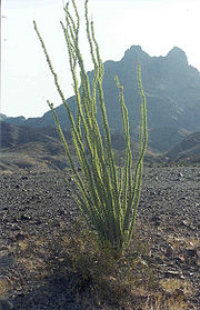
. The wilderness area is made up of the highest peak in the southern section of Muggins Mountains, Klothos Temple at 1666 feet (508 m). Muggins Peak is adjacent to the peak southeastwards, at 1424 feet (434 m). Three deeply cut washes drain the southwest border of the wilderness, Twin Tanks Wash, Muggins Wash, and Morgan Wash. Muggins Wash is the access point to the wilderness, by way of County 7th Street.
The ruggedness of the Muggins Mountains Wilderness is ideal for activities such as day hiking, backpacking, rock climbing, sightseeing, photography, and studying nature, native plants, or wildlife.
The nearest communities are Dome
Dome, Arizona
Dome is a ghost town located in Yuma County, in southwestern Arizona, United States. Originally Swiveler's Station, 20 miles east of Fort Yuma, on the Butterfield Overland Mail route, a post office was established here in 1858...
, Ligurta, or Wellton
Wellton, Arizona
Wellton is a town in Yuma County, Arizona, United States. According to 2006 Census Bureau estimates, the population of the town is 1,862. It is part of the Yuma Metropolitan Statistical Area.-Geography:Wellton is located at ....
in the Dome or Mohawk Valley
Mohawk Valley (Arizona)
The Mohawk Valley is a valley in the lower regions of the western Gila River Valley in southwestern Arizona in the western Sonoran Desert....
s; the Fortuna Foothills
Fortuna Foothills, Arizona
Fortuna Foothills is a census-designated place in Yuma County, Arizona, United States. The population was 20,478 at the 2000 census. It is part of the Yuma Metropolitan Statistical Area.-Geography:...
suburb of Yuma is located west over the Gila Mountains (Yuma County)
Gila Mountains (Yuma County)
The Gila Mountains is a mountain range in southwestern Arizona in the northwestern Sonoran Desert.The Gila Mountains of Yuma County are a northwest-southeast trending mountain system, about 26 miles long; the fault-blocked mountain range is attached on the south to the Tinajas Altas Mountains...
.
See also
- Muggins MountainsMuggins MountainsThe Muggins Mountains is a mountain range in southwest Arizona east of Yuma, Arizona, northeast of the Gila Mountains , and east of the Laguna Mountains...
- (includes a 3-mountain range area description) - Muggins Mountains Wilderness floraMuggins Mountains Wilderness floraThis is a list of Muggins Mountains Wilderness flora. The Muggins Wilderness covers about 15-20 percent of the Muggins Mountains, , and is on the southwest of the triangular mountain region; the southwest mountain flank is block faulted and parallels the northwest-southeast Dome Valley and the...
- List of LCRV Wilderness Areas (Colorado River)
- List of Arizona Wilderness Areas
External links
- BLM Muggins Mountains Wilderness site
- National Wilderness Preservation System: "Muggins Mountain Wilderness" site
- Public Lands Muggins Mountains Wilderness site Muggins MountainsMuggins MountainsThe Muggins Mountains is a mountain range in southwest Arizona east of Yuma, Arizona, northeast of the Gila Mountains , and east of the Laguna Mountains...
map and region: http://www.publiclands.org/explore/quadrant_map.php?id=502&site_name=Muggins%20Mountains%20Wilderness&quad=AZ_Q24
Southwestern Arizona Region: