

Muddy Creek (Utah)
Encyclopedia
Emery County, Utah
Emery County is a county located in the U.S. state of Utah. As of 2000 the population was 10,860, and by 2009 had been estimated to decrease to 10,629. It was named for George W. Emery, governor of the Utah Territory in 1875...
and Wayne
Wayne County, Utah
Wayne County is a county located in the U.S. state of Utah. It was formed from Piute County in 1892. The county gets its name from a man who served as delegate to the constitutional convention, in honor of his son who was dragged to death by a horse. As of 2000 the population was 2,509, and by...
Counties in central Utah
Utah
Utah is a state in the Western United States. It was the 45th state to join the Union, on January 4, 1896. Approximately 80% of Utah's 2,763,885 people live along the Wasatch Front, centering on Salt Lake City. This leaves vast expanses of the state nearly uninhabited, making the population the...
, in the western United States
United States
The United States of America is a federal constitutional republic comprising fifty states and a federal district...
. It begins on the eastern slopes of the Wasatch Plateau at elevations above 10,500 feet (3200 m). It turns southward near the town of Emery
Emery, Utah
Emery is a town in Emery County, Utah, United States. The population was 308 at the 2000 census.-Prehistoric:Emery sits at the base of the mountains that contain the North Horn Formation. Named after North Horn Mountain, near Castle Dale, Utah this formation in Emery County contain numerous...
, then southeastward where it crosses under Interstate 70
Interstate 70
Interstate 70 is an Interstate Highway in the United States that runs from Interstate 15 near Cove Fort, Utah, to a Park and Ride near Baltimore, Maryland. It was the first Interstate Highway project in the United States. I-70 approximately traces the path of U.S. Route 40 east of the Rocky...
. It then directly enters the western flank of the San Rafael Swell
San Rafael Swell
The San Rafael Swell is a large geologic feature located in south-central Utah, USA about 30 miles west of Green River, Utah. The San Rafael Swell, approximately by , consists of a giant dome-shaped anticline of sandstone, shale, and limestone that was pushed up during the Paleocene Laramide...
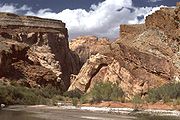
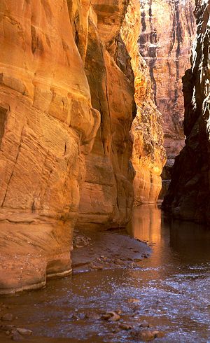
and continuing in southeasterly direction, it passes Hondu Arch and the Tomsich Butte mining area, then begins its spectacular passage through a narrow slot canyon of Coconino Sandstone
Coconino Sandstone
Coconino Sandstone is a geologic formation named after its exposure in Coconino County, Arizona. This formation spreads across the Colorado Plateau province of the United States, including northern Arizona, northwest Colorado, Nevada, and Utah....
known as the "Chute".
After merging with Chimney Canyon and passing the Hidden Splendor Mine area, it passes out through the southeastern escarpment of the San Rafael Reef
San Rafael Reef
The San Rafael Reef is a geologic feature located in Emery County in central Utah, part of the Colorado Plateau. Approximately 75 miles long, it is the name given to the distinctive eastern edge of the San Rafael Swell...
at the end of Muddy Creek Gorge. In its lower reaches it continues southeastward through the Blue Hills badlands
Badlands
A badlands is a type of dry terrain where softer sedimentary rocks and clay-rich soils have been extensively eroded by wind and water. It can resemble malpaís, a terrain of volcanic rock. Canyons, ravines, gullies, hoodoos and other such geological forms are common in badlands. They are often...
near Caineville then cuts through the Jurassic Morrison Formation
Morrison Formation
The Morrison Formation is a distinctive sequence of Late Jurassic sedimentary rock that is found in the western United States, which has been the most fertile source of dinosaur fossils in North America. It is composed of mudstone, sandstone, siltstone and limestone and is light grey, greenish...
where dinosaur
Dinosaur
Dinosaurs are a diverse group of animals of the clade and superorder Dinosauria. They were the dominant terrestrial vertebrates for over 160 million years, from the late Triassic period until the end of the Cretaceous , when the Cretaceous–Paleogene extinction event led to the extinction of...
fossils have been found. Finally, after an estimated length of 100 miles (160 km) and a drop of 6,000 feet (1825 m), it meets the Fremont River
Fremont River (Utah)
The Fremont River in Utah flows from the Johnson Valley Reservoir, which is located on the Wasatch Plateau near Fish Lake, southwest through Capitol Reef National Park to the Muddy Creek near Hanksville where the two rivers combine to form the Dirty Devil River, a tributary of the Colorado River...
some miles north of the town of Hanksville
Hanksville, Utah
Hanksville is a small town in Wayne County, Utah, United States, at the junction of State Routes 24 and 95. The town is just south of the confluence of the Fremont River and Muddy Creek, which together form the Dirty Devil River, which then flows southeast to the Colorado River...
where the two form the Dirty Devil River
Dirty Devil River
The Dirty Devil River is a long tributary of the Colorado River, located in the U.S. state of Utah. It flows through southern Utah from the confluence of Fremont River and Muddy Creek to the Colorado River.-Course:...
(which then flows south to meet the Colorado River
Colorado River
The Colorado River , is a river in the Southwestern United States and northwestern Mexico, approximately long, draining a part of the arid regions on the western slope of the Rocky Mountains. The watershed of the Colorado River covers in parts of seven U.S. states and two Mexican states...
).
Since it enters the San Rafael Swell at elevation well below that attained by the Swell itself, and continues through the Swell's entire expanse, Muddy Creek is a very ancient river course, "superimposed" on the entire San Rafael uplift and therefore predating the time when the latter arose some 60-40 million years ago.
See also
- List of Utah rivers
- List of tributaries of the Colorado River
- Quitchupah CreekQuitchupah CreekQuitchupah Creek is a stream draining portions of Emery and Sevier Counties in central Utah, in the western United States. Quitchupah Creek is significant for its rock art remains of the Fremont culture that line its banks...