
Mount Williamson
Encyclopedia
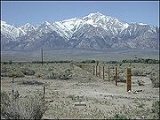
Mount Williamson, at 14389 feet (4,386 m), is the second highest mountain in both the Sierra Nevada range and the state of California
. It is the sixth highest peak in the contiguous United States
.
of the Inyo National Forest
. It is located approximately 6 miles (9.7 km) north of Mount Whitney
, the highest peak in the contiguous U.S., and about 2.5 miles (4 km) southeast of Shepherd Pass, the nearest trail access. The closest town is Independence, California
, about 12 miles (19.3 km) north-north-east of the peak in the Owens Valley
. It lies about 1 miles (1.6 km) east of the Sierra Crest, which forms the western edge of the Owens Valley. It is more remote than Whitney in terms of access; however, as it sits east of the crest, it is actually a bit closer to the Owens Valley floor than Whitney. For example, the drop from the summit to the forest edge is 8000 feet (2,438.4 m) in approximately 4 miles (6.4 km). This makes it an imposing mountain, and far less of a popular climb than its higher neighbor.
(1825–1882), who conducted one of the Pacific Railroad Surveys
in Southern California.
The first recorded ascent of Mount Williamson was made in 1884 by W. L. Hunter and C. Mulholland, by way of the Southeast Slopes Route. The first ascent of the West Side Route was made in 1896 by Bolton C. Brown and Lucy Brown. New routes continued to be put up on the harder faces at least through the 1980s.
, part of the Sierra Crest. The bowl is home to five high alpine lakes. From the bowl, the route climbs gullies up the west face to the relatively broad summit plateau; this portion involves scrambling
up to . Technically easier, but with a more difficult approach which can involve route finding and bushwhacking, is the Southeast Slopes Route, rising from George Creek. Other routes exist on the mountain, including a significant technical route on the North Rib (Grade IV, 5.7
).
Climbing Mount Williamson is made more difficult by the lengthy and strenuous approach. Elevation gain from the trailhead is over 8000 feet (2,438.4 m), and the trail to Shepherd's Pass alone is 11 miles (17.7 km).
Mount Williamson is in the California Bighorn Sheep
Zoological Area and these rare animals can often be seen on the lower slopes during the winter when heavy snows drive the sheep down from their summer grazing areas. From 1981 until 2010 the California Bighorn Sheep Zoological Area was closed to access for much of the year, but late in 2010, the Inyo National Forest Service declined to renew the closure, opening the area to access year-round.
California
California is a state located on the West Coast of the United States. It is by far the most populous U.S. state, and the third-largest by land area...
. It is the sixth highest peak in the contiguous United States
Contiguous United States
The contiguous United States are the 48 U.S. states on the continent of North America that are south of Canada and north of Mexico, plus the District of Columbia....
.
Geography
Williamson stands in the John Muir WildernessJohn Muir Wilderness
The John Muir Wilderness is a wilderness area that extends along the crest of the Sierra Nevada of California, USA for , in the Inyo and Sierra National Forests. Established in 1964 by the Wilderness Act and named for naturalist John Muir, it contains...
of the Inyo National Forest
Inyo National Forest
Inyo National Forest is a federally administered forest in the United States. The forest covers parts of the eastern Sierra Nevada of California, and the White Mountains of California and Nevada. It contains two wilderness areas: the John Muir Wilderness and the Ansel Adams Wilderness...
. It is located approximately 6 miles (9.7 km) north of Mount Whitney
Mount Whitney
Mount Whitney is the highest summit in the contiguous United States with an elevation of . It is on the boundary between California's Inyo and Tulare counties, west-northwest of the lowest point in North America at Badwater in Death Valley National Park...
, the highest peak in the contiguous U.S., and about 2.5 miles (4 km) southeast of Shepherd Pass, the nearest trail access. The closest town is Independence, California
Independence, California
Independence is the county seat of Inyo County, California. Independence is located south-southeast of Bishop, at an elevation of 3930 feet . The population of this census-designated place was 669 at the 2010 census, up from 574 at the 2000 census....
, about 12 miles (19.3 km) north-north-east of the peak in the Owens Valley
Owens Valley
Owens Valley is the arid valley of the Owens River in eastern California in the United States, to the east of the Sierra Nevada and west of the White Mountains and Inyo Mountains on the west edge of the Great Basin section...
. It lies about 1 miles (1.6 km) east of the Sierra Crest, which forms the western edge of the Owens Valley. It is more remote than Whitney in terms of access; however, as it sits east of the crest, it is actually a bit closer to the Owens Valley floor than Whitney. For example, the drop from the summit to the forest edge is 8000 feet (2,438.4 m) in approximately 4 miles (6.4 km). This makes it an imposing mountain, and far less of a popular climb than its higher neighbor.
History
The mountain is named for Lt. Robert Stockton WilliamsonRobert S. Williamson
Robert Stockton Williamson was an American soldier and engineer, noted for conducting surveys for the transcontinental railroad in California and Oregon.-Early life and career:...
(1825–1882), who conducted one of the Pacific Railroad Surveys
Pacific Railroad Surveys
The Pacific Railroad Surveys -A series of explorations of the American West to explore possible routes for a transcontinental railroad across North America. The expeditions included surveyors, scientists, and artists and resulted in an immense body of data covering at least on the American West....
in Southern California.
The first recorded ascent of Mount Williamson was made in 1884 by W. L. Hunter and C. Mulholland, by way of the Southeast Slopes Route. The first ascent of the West Side Route was made in 1896 by Bolton C. Brown and Lucy Brown. New routes continued to be put up on the harder faces at least through the 1980s.
Climbing
The standard ascent route is the West Side Route, accessed from Shepherd's Pass. From the pass, one travels across the Williamson Bowl, which lies between Mount Williamson and Mount TyndallMount Tyndall
Mount Tyndall is a peak in the Mount Whitney region of the Sierra Nevada in the U.S. state of California. It rises to , and is the tenth highest peak in the state...
, part of the Sierra Crest. The bowl is home to five high alpine lakes. From the bowl, the route climbs gullies up the west face to the relatively broad summit plateau; this portion involves scrambling
Scrambling
Scrambling is a method of ascending rocky faces and ridges. It is an ambiguous term that lies somewhere between hillwalking and rock climbing. It is often distinguished from hillwalking by defining a scramble as a route where hands must be used in the ascent...
up to . Technically easier, but with a more difficult approach which can involve route finding and bushwhacking, is the Southeast Slopes Route, rising from George Creek. Other routes exist on the mountain, including a significant technical route on the North Rib (Grade IV, 5.7
Yosemite Decimal System
The Yosemite Decimal System is a three-part system used for rating the difficulty of walks, hikes, and climbs. It is primarily used by mountaineers in the United States and Canada. The Class 5 portion of the Class scale is primarily a rock climbing classification system. Originally the system was...
).
Climbing Mount Williamson is made more difficult by the lengthy and strenuous approach. Elevation gain from the trailhead is over 8000 feet (2,438.4 m), and the trail to Shepherd's Pass alone is 11 miles (17.7 km).
Mount Williamson is in the California Bighorn Sheep
Sierra Nevada Bighorn Sheep
Sierra Nevada bighorn sheep is a subspecies of bighorn sheep. Early taxonomic schemes included herds from British Columbia to southern California in a broader subspecies Ovis canadensis californiana. More recent genetic testing has indicated that O. c...
Zoological Area and these rare animals can often be seen on the lower slopes during the winter when heavy snows drive the sheep down from their summer grazing areas. From 1981 until 2010 the California Bighorn Sheep Zoological Area was closed to access for much of the year, but late in 2010, the Inyo National Forest Service declined to renew the closure, opening the area to access year-round.
See also
- California 4000 meter peaks
- List of California fourteeners
- Mountain peaks of CaliforniaMountain peaks of CaliforniaThis article comprises three sortable tables of major mountain peaks of the U.S. State of California.Topographic elevation is the vertical distance above the reference geoid, a precise mathematical model of the Earth's sea level as an equipotential gravitational surface...
- Mountain peaks of North AmericaMountain peaks of North AmericaThis article comprises three sortable tables of major mountain peaks of greater North America.This article defines greater North America as the portion of the continental landmass of the Americas extending northward from Panama plus the islands surrounding that landmass...
- Mountain peaks of the United StatesMountain peaks of the United StatesThis article comprises three sortable tables of the major mountain peaks of the United States of America.Topographic elevation is the vertical distance above the reference geoid, a precise mathematical model of the Earth's sea level as an equipotential gravitational surface...