
Mount Tenpo
Encyclopedia
located in Minato-ku, Osaka
is commonly recognized as Japan's lowest mountain. The definition of a "mountain" used here is any elevation described as a mountain on a topographic map
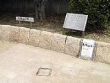
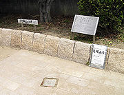
published by the Geographical Survey Institute of Japan, though it is disputed that the mountain lacks credibility because it is not a natural part of the landscape. The mountain's "peak" is 4.53 meters above sea level, and will bear more resemblance to a hill than a mountain to the casual observer. A small port is located nearby, and much of the mountain's surface has been converted into a park.
 Mount Tenpō was formed in 1831 (Tenpō year 2
) as the deposit for earth dug up from dredging the Ajigawa river to allow easier access to Osaka for large ships and to prevent floods. The mountain had an elevation of about 20 meters at the time, and served as a marker for ships entering the Ajigawa river to head to the city of Osaka. Cherry blossom and pine trees were planted on the mountain as people began to set up shops in the area, and the mountain gradually became the visitor attraction that it is now. Images of children playing in this area were sketched in ukiyo-e
by Utagawa Hiroshige
and other artists.
Part of the mountain was leveled to set up an artillery unit to protect the river pass after the fall of the Tokugawa shogunate
. As industrialization progressed in the Taishō
and Shōwa
periods, overuse of groundwater
resulted in subsidence
, lowering the mountain's elevation even further. This caused the mountain's name to be erased from topographic maps until it was reinstated due to fierce protests from local residents.
stop of the Chūō Line.
, the park itself contains large hills (the deposits for earth dug up in constructing underground train tunnels) which have much higher elevations than the actual "peak" of the mountain.
A stone memorial of the Meiji Emperor's first sea-borne military parade in 1868 is located next to the triangular peak of the mountain. The park's clock-tower was originally a prop for a television show produced by the Kansai Telecasting Corporation
, but was later donated to the prefecture. The park contains several other statues of important figures, along with reproductions of ukiyo-e art depicting the area during the Edo period
.
and the Suntory Museum. The Hanshin Expressway
also has an exit named after Mount Tenpō.
Minato-ku, Osaka
is one of 24 wards of Osaka, Japan. It has an area of 7.9 km², and a population of 84,961. Minato-ku literally translated means Harbor Ward.- Landmarks :*Kaiyukan *Port of Osaka*Tempozan Harbor Village*Modern Transportation Museum...
is commonly recognized as Japan's lowest mountain. The definition of a "mountain" used here is any elevation described as a mountain on a topographic map
Topographic map
A topographic map is a type of map characterized by large-scale detail and quantitative representation of relief, usually using contour lines in modern mapping, but historically using a variety of methods. Traditional definitions require a topographic map to show both natural and man-made features...
published by the Geographical Survey Institute of Japan, though it is disputed that the mountain lacks credibility because it is not a natural part of the landscape. The mountain's "peak" is 4.53 meters above sea level, and will bear more resemblance to a hill than a mountain to the casual observer. A small port is located nearby, and much of the mountain's surface has been converted into a park.
History
Tenpo
was a , also known as Tempō, after Bunsei and before Kōka. The period spanned the years from December 1830 through December 1844...
) as the deposit for earth dug up from dredging the Ajigawa river to allow easier access to Osaka for large ships and to prevent floods. The mountain had an elevation of about 20 meters at the time, and served as a marker for ships entering the Ajigawa river to head to the city of Osaka. Cherry blossom and pine trees were planted on the mountain as people began to set up shops in the area, and the mountain gradually became the visitor attraction that it is now. Images of children playing in this area were sketched in ukiyo-e
Ukiyo-e
' is a genre of Japanese woodblock prints and paintings produced between the 17th and the 20th centuries, featuring motifs of landscapes, tales from history, the theatre, and pleasure quarters...
by Utagawa Hiroshige
Hiroshige
was a Japanese ukiyo-e artist, and one of the last great artists in that tradition. He was also referred to as Andō Hiroshige and by the art name of Ichiyūsai Hiroshige ....
and other artists.
Part of the mountain was leveled to set up an artillery unit to protect the river pass after the fall of the Tokugawa shogunate
Tokugawa shogunate
The Tokugawa shogunate, also known as the and the , was a feudal regime of Japan established by Tokugawa Ieyasu and ruled by the shoguns of the Tokugawa family. This period is known as the Edo period and gets its name from the capital city, Edo, which is now called Tokyo, after the name was...
. As industrialization progressed in the Taishō
Taisho period
The , or Taishō era, is a period in the history of Japan dating from July 30, 1912 to December 25, 1926, coinciding with the reign of the Taishō Emperor. The health of the new emperor was weak, which prompted the shift in political power from the old oligarchic group of elder statesmen to the Diet...
and Shōwa
Showa period
The , or Shōwa era, is the period of Japanese history corresponding to the reign of the Shōwa Emperor, Hirohito, from December 25, 1926 through January 7, 1989.The Shōwa period was longer than the reign of any previous Japanese emperor...
periods, overuse of groundwater
Groundwater
Groundwater is water located beneath the ground surface in soil pore spaces and in the fractures of rock formations. A unit of rock or an unconsolidated deposit is called an aquifer when it can yield a usable quantity of water. The depth at which soil pore spaces or fractures and voids in rock...
resulted in subsidence
Groundwater-related subsidence
Groundwater-related subsidence is the subsidence of land resulting from groundwater extraction, and a major problem in the developing world as major metropolises swell without adequate regulation and enforcement, as well as a being a common problem in the developed world...
, lowering the mountain's elevation even further. This caused the mountain's name to be erased from topographic maps until it was reinstated due to fierce protests from local residents.
Location
The mountain is located about 400 meters north of the Ōsakakō StationOsakako Station
is a train station on the Osaka Municipal Subway Chūō Line in Minato-ku, Osaka, Japan. It is the stop that services the Osaka Aquarium Kaiyukan.-Layout:*There is an elevated island platform with two tracks on the third floor.-Stations next to Osakako:...
stop of the Chūō Line.
Mount Tenpō Park
The mountain's surface is currently known as . Surrounded by a large leveeLevee
A levee, levée, dike , embankment, floodbank or stopbank is an elongated naturally occurring ridge or artificially constructed fill or wall, which regulates water levels...
, the park itself contains large hills (the deposits for earth dug up in constructing underground train tunnels) which have much higher elevations than the actual "peak" of the mountain.
A stone memorial of the Meiji Emperor's first sea-borne military parade in 1868 is located next to the triangular peak of the mountain. The park's clock-tower was originally a prop for a television show produced by the Kansai Telecasting Corporation
Kansai Telecasting Corporation
, often called or , is a TV station affiliated with Fuji News Network and Fuji Network System in Osaka, serving the Kansai region of Japan...
, but was later donated to the prefecture. The park contains several other statues of important figures, along with reproductions of ukiyo-e art depicting the area during the Edo period
Edo period
The , or , is a division of Japanese history which was ruled by the shoguns of the Tokugawa family, running from 1603 to 1868. The political entity of this period was the Tokugawa shogunate....
.
Surrounding area
The mountain is located near several leisure and amusement facilities, including the Osaka Aquarium KaiyukanOsaka Aquarium Kaiyukan
The is an aquarium located in the ward of Minato in Osaka, Japan, near Osaka Bay. It is one of the largest public aquariums in the world, and is a member of the Japanese Association of Zoos and Aquariums ....
and the Suntory Museum. The Hanshin Expressway
Hanshin Expressway
The is a network of expressways surrounding Osaka, Kobe and Kyoto, Japan. Operated by , it opened in 1962.Portions of the Hanshin Expressway collapsed during the Kobe earthquake on January 17, 1995. These sections were rebuilt by 1996...
also has an exit named after Mount Tenpō.