

Mount Pisgah (Oregon)
Encyclopedia
Lane County, Oregon
-National protected areas:*Oregon Islands National Wildlife Refuge *Siuslaw National Forest *Umpqua National Forest *Willamette National Forest -Government:...
, Oregon
Oregon
Oregon is a state in the Pacific Northwest region of the United States. It is located on the Pacific coast, with Washington to the north, California to the south, Nevada on the southeast and Idaho to the east. The Columbia and Snake rivers delineate much of Oregon's northern and eastern...
, United States
United States
The United States of America is a federal constitutional republic comprising fifty states and a federal district...
, rising 1060 feet (323.1 m) above the surrounding Willamette Valley
Willamette Valley
The Willamette Valley is the most populated region in the state of Oregon of the United States. Located in the state's northwest, the region is surrounded by tall mountain ranges to the east, west and south and the valley's floor is broad, flat and fertile because of Ice Age conditions...
to a maximum elevation of 1531 feet (466.6 m). It was named after the biblical Mount Pisgah
Mount Pisgah (Bible)
Some translators of the biblical book of Deuteronomy translate Pisgah as a name of a mountain, usually referring to Mount Nebo. The region is directly east of the Jordan River and just northeast of the Dead Sea. Mount Nebo is the highest among a handful of Pisgah summits; an arid cluster of...
. It is situated between the Coast Fork
Coast Fork Willamette River
The Coast Fork Willamette River is one of several forks that unite to form the Willamette River in western Oregon in the United States. It is about long, draining an area of the mountains at the south end of the Willamette Valley south of Eugene.-Course:...
and Middle Fork
Middle Fork Willamette River
The Middle Fork Willamette River is one of several forks that unite to form the Willamette River in the western part of the U.S. state of Oregon...
of the Willamette River
Willamette River
The Willamette River is a major tributary of the Columbia River, accounting for 12 to 15 percent of the Columbia's flow. The Willamette's main stem is long, lying entirely in northwestern Oregon in the United States...
, two miles (3 km) southeast of their confluence. Springfield
Springfield, Oregon
Springfield is a city in Lane County, Oregon, United States. Located in the Southern Willamette Valley, it is within the Eugene-Springfield Metropolitan Statistical Area. Separated from Eugene to the west, mainly by Interstate 5, Springfield is the second-most populous city in the metropolitan area...
is immediately north of Mount Pisgah, and the city of Eugene
Eugene, Oregon
Eugene is the second largest city in the U.S. state of Oregon and the seat of Lane County. It is located at the south end of the Willamette Valley, at the confluence of the McKenzie and Willamette rivers, about east of the Oregon Coast.As of the 2010 U.S...
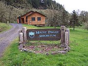
is a few miles west. It hosts the 2363-acre (956 hectare) Howard Buford Recreation Area as well as the non-profit Mount Pisgah Arboretum
Mount Pisgah Arboretum
The Mount Pisgah Arboretum is a non-profit arboretum and botanical garden located within the Howard Buford Recreation Area , between the Coast Fork of the Willamette River and the slopes of Mount Pisgah near Eugene-Springfield, Oregon, United States...
at its base.
Recreation
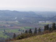
The summit offers a panoramic view of the southern Willamette Valley and includes a bronze relief sculpture (a memorial for Ken Kesey
Ken Kesey
Kenneth Elton "Ken" Kesey was an American author, best known for his novel One Flew Over the Cuckoo's Nest , and as a counter-cultural figure who considered himself a link between the Beat Generation of the 1950s and the hippies of the 1960s. "I was too young to be a beatnik, and too old to be a...
's son Jed) illustrating the surrounding topography and identifying many nearby geographic features.
Arboretum
The Mount Pisgah ArboretumMount Pisgah Arboretum
The Mount Pisgah Arboretum is a non-profit arboretum and botanical garden located within the Howard Buford Recreation Area , between the Coast Fork of the Willamette River and the slopes of Mount Pisgah near Eugene-Springfield, Oregon, United States...
covers 209 acre (0.84579374 km²) at the base of Mount Pisgah and offers visitors 7 miles (11.3 km) of trails through natural riverside habitat and hundreds of catalogued plant species. Admission is $3 per car and permits can be purchased at a self-service pay station.
Geology
The hill consists of basaltBasalt
Basalt is a common extrusive volcanic rock. It is usually grey to black and fine-grained due to rapid cooling of lava at the surface of a planet. It may be porphyritic containing larger crystals in a fine matrix, or vesicular, or frothy scoria. Unweathered basalt is black or grey...
or its intrusive equivalent diabase
Diabase
Diabase or dolerite is a mafic, holocrystalline, subvolcanic rock equivalent to volcanic basalt or plutonic gabbro. In North American usage, the term diabase refers to the fresh rock, whilst elsewhere the term dolerite is used for the fresh rock and diabase refers to altered material...
. Small crystals of calcite and various zeolite
Zeolite
Zeolites are microporous, aluminosilicate minerals commonly used as commercial adsorbents. The term zeolite was originally coined in 1756 by Swedish mineralogist Axel Fredrik Cronstedt, who observed that upon rapidly heating the material stilbite, it produced large amounts of steam from water that...
minerals are often seen where the rock outcrops, especially near the summit.
Controversy
Wildish Land Company owns 1400 acres (5.7 km²) of undisturbed land adjacent to the park and has filed an Oregon Measure 37Oregon Ballot Measure 37 (2004)
Oregon Ballot Measure 37 is a controversial land-use ballot initiative that passed in the U.S. state of Oregon in 2004 and is now codified as Oregon Revised Statutes 195.305. Measure 37 has figured prominently in debates about the rights of property owners versus the public's right to enforce...
claim. The claim seeks either compensation of $15 million for diminution in land value caused by state and county land use regulations enacted since Wildish acquired the property, or in the alternative, a waiver of offending land use regulations enacted since its acquisition. The land is zoned for gravel production with an estimated value, under current zoning, at around $5 million. As an alternative to development or compensation, some have suggested the controversy represents a historic opportunity to purchase the land, integrate it with the existing park, and eventually link the expanded Howard Buford Recreation Area with other undeveloped land as part of a greater Eugene greenway.
On December 6, 2006, Lane County approved Wildish's Measure 37 claim, waiving non-exempt offending regulations enacted since Wildish acquired the property. The Oregon Department of Administrative Services
Oregon Department of Administrative Services
The Department of Administrative Services is the agency of the government of the U.S. state of Oregon which is chiefly responsible, through its nine divisions, for administering all of the programs of the Governor and the executive branch, as well as providing administrative and support services to...
has not yet ruled on Wildish's state application. Before any development may happen, Wildish must still receive a waiver from the state, and it must still submit a development application to the county.