

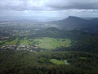
Mount Nebo (New South Wales)
Encyclopedia
Hill
A hill is a landform that extends above the surrounding terrain. Hills often have a distinct summit, although in areas with scarp/dip topography a hill may refer to a particular section of flat terrain without a massive summit A hill is a landform that extends above the surrounding terrain. Hills...
, part of the Illawarra escarpment
Illawarra escarpment
The Illawarra Escarpment is the fold created cliffs and plateau eroded outcrop mountain range west of the Illawarra coastal plain south of Sydney, Australia, enclosing the region known as the Illawarra which stretches from Stanwell Park in the north to Kiama, Gerringong and the Shoalhaven river in...
foothills on the edge of the suburban fringe of the city of Wollongong
Wollongong, New South Wales
Wollongong is a seaside city located in the Illawarra region of New South Wales, Australia. It lies on the narrow coastal strip between the Illawarra Escarpment and the Pacific Ocean, 82 kilometres south of Sydney...
, New South Wales
New South Wales
New South Wales is a state of :Australia, located in the east of the country. It is bordered by Queensland, Victoria and South Australia to the north, south and west respectively. To the east, the state is bordered by the Tasman Sea, which forms part of the Pacific Ocean. New South Wales...
. Its summit (252 metres above sea level), is reached by a steep road (O'Brien's Road) from the suburb of Figtree
Figtree, New South Wales
Figtree is an inner western suburb of Wollongong, New South Wales, Australia. It is southwest of West Wollongong and connected to Wollongong by the Princes Highway and The Avenue....
. O'Brien's Road is unusual in that it was built as a private toll road in the early 19th century to connect Sydney
Sydney
Sydney is the most populous city in Australia and the state capital of New South Wales. Sydney is located on Australia's south-east coast of the Tasman Sea. As of June 2010, the greater metropolitan area had an approximate population of 4.6 million people...
and the Illawarra
Illawarra
Illawarra is a region in the Australian state of New South Wales. It is a coastal region situated immediately south of Sydney and north of the Shoalhaven or South Coast region. It encompasses the cities of Wollongong, Shellharbour, Shoalhaven and the town of Kiama. The central region contains Lake...
. O'Briens Road began at the locally famous fig tree that gave the name to Figtree
Figtree, New South Wales
Figtree is an inner western suburb of Wollongong, New South Wales, Australia. It is southwest of West Wollongong and connected to Wollongong by the Princes Highway and The Avenue....
. Views from the top look over Wollongong, Lake Illawarra
Lake Illawarra
Lake Illawarra is a large coastal lagoon located in the city of Wollongong about 100 km south of Sydney, New South Wales.The lake receives runoff from the Illawarra escarpment through Macquarie Rivulet and Mullet Creek, and has a narrow tidal entrance to the sea at Windang...
and the local mountains. Nebo was the aboriginal name for the hill, and the name has been kept as in the case of Woonona
Woonona, New South Wales
Woonona is a northern suburb of Wollongong, New South Wales, Australia, on the northern area of the Illawarra coastal plain. It is served by Woonona Station on the South Coast Line, and by the Princes Highway....
Mountain and Mount Warrigal hill at Lake Illawarra
Lake Illawarra
Lake Illawarra is a large coastal lagoon located in the city of Wollongong about 100 km south of Sydney, New South Wales.The lake receives runoff from the Illawarra escarpment through Macquarie Rivulet and Mullet Creek, and has a narrow tidal entrance to the sea at Windang...
.
In 1999 the council stopped vehicles from continuing from the summit due to illegal dumping, and the road has become a track to O'Brien's Gap and Mount Brisbane, (469 metres above sea level). However litter remains a problem.
The hill provides excellent views of Mount Kembla
Mount Kembla
Mount Kembla is a mountain in New South Wales, Australia, as well a semi-rural township of Wollongong, which gets its name from the mountain.Kembla is an Aboriginal word meaning "plenty of game"....
and Mount Keira
Mount Keira
Mount Keira is a 464 metre high mountain lying 4 kilometres northwest of the city of Wollongong, New South Wales, Australia. Its distinctive shape and proximity to Wollongong make it a major local landmark. It is noted for the views of the city from the popular summit lookout and its history of...
and is popular for photograph taking. It is connected to the Illawarra escarpment
Illawarra escarpment
The Illawarra Escarpment is the fold created cliffs and plateau eroded outcrop mountain range west of the Illawarra coastal plain south of Sydney, Australia, enclosing the region known as the Illawarra which stretches from Stanwell Park in the north to Kiama, Gerringong and the Shoalhaven river in...
by Nebo Ridge. From the end of the trafficable part of O'Briens Road a short trail climbs to the summit area where, near television re-transmission towers and a water tank, one has almost 360 degree views, excluding that which the summit blocks. from here the Illawarra
Illawarra
Illawarra is a region in the Australian state of New South Wales. It is a coastal region situated immediately south of Sydney and north of the Shoalhaven or South Coast region. It encompasses the cities of Wollongong, Shellharbour, Shoalhaven and the town of Kiama. The central region contains Lake...
Coastal Plain is obvious, with the hills of Mount Mangerton, Mount Saint Thomas and Cobblers Hill appearing amidst residential areas. To the southeast lies Saddleback Mountain
Saddleback Mountain (New South Wales)
Saddleback Mountain is a mountain in New South Wales, Australia which rises to about 600 metres above sea level and has spectacular views of Noorinan Mountain, 662 metres above sea level, and Barren Grounds Plateau to the west and south to Coolangatta Mountain and Pigeon House Mountain to...
, Noorinan Mountain and Barren Grounds Nature Reserve, Knights Hill, the southern escarpment and, most obviously, Mount Kembla
Mount Kembla
Mount Kembla is a mountain in New South Wales, Australia, as well a semi-rural township of Wollongong, which gets its name from the mountain.Kembla is an Aboriginal word meaning "plenty of game"....
and Kembla West.
The popular walking and bridle track goes from near the summit (a vegetated area east of the towers), down along Nebo Ridge, which rises to its own summit giving breathtaking views of Mount Keira
Mount Keira
Mount Keira is a 464 metre high mountain lying 4 kilometres northwest of the city of Wollongong, New South Wales, Australia. Its distinctive shape and proximity to Wollongong make it a major local landmark. It is noted for the views of the city from the popular summit lookout and its history of...
, Mount Brisbane and the colliery below. Many species of birds, snakes and plants are found here, as well as the problematic imported deer and Lantana
Lantana
Lantana is a genus of about 150 species of perennial flowering plants in the verbena family, Verbenaceae. They are native to tropical regions of the Americas and Africa but exist as an introduced species in numerous areas, especially in the Australian-Pacific region. The genus includes both...
. The track remains fairly consistent except for one section where it climbs very steeply up a hundred metre hill before going along the side of Pupiana, an extension of Mount Brisbane. The track then makes its way past a waterfall, unused water pipes and a gate to Harry Graham Drive, a popular tourist route along the escarpment. From here it is a short walk to the Motocross Track and the Stafford's Farm Track.
The east and south sides of the hill have been encroached by residential development. The southwest slopes are taken up by agriculture and in the valley to the southwest is the Mount Nebo Colliery in the Kemira valley, the name comes from Mount Kembla
Mount Kembla
Mount Kembla is a mountain in New South Wales, Australia, as well a semi-rural township of Wollongong, which gets its name from the mountain.Kembla is an Aboriginal word meaning "plenty of game"....
and Mount Keira
Mount Keira
Mount Keira is a 464 metre high mountain lying 4 kilometres northwest of the city of Wollongong, New South Wales, Australia. Its distinctive shape and proximity to Wollongong make it a major local landmark. It is noted for the views of the city from the popular summit lookout and its history of...
, two prominent local mountains. The track is becoming a popular walking and jogging track as well as a birdwatching site, due to the open feeling and remoteness from settlement. The old road is crumbled in several sections, but this does not stop walkers.