

Mount Iwaki
Encyclopedia
is a stratovolcano
located in western Aomori Prefecture
, Tohoku, Japan
. It is also referred to as Tsugaru-Fuji from its shape. the mountain is listed as one of the 100 Famous Japanese Mountains in a book composed in 1964 by mountaineer
/author
Kyūya Fukada
. The mountain and its surroundings are located within the borders of Tsugaru Quasi-National Park
.
. Its summit crater is two kilometers wide, and it has three lava dome
s on the western and southern flanks. The mountain has frequently been active in historic times, with very frequent activity consisting mostly of small to moderate phreatic explosions during the Edo period
. The last known eruption was on March 23, 1863. Hirosaki University
has maintained an observatory with a total of 18 telemetering stations on the mountain since 1981.
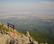 The summit, at 1625 meters, can be reached only by hiking, but the length of the hike depends on the route. From , it takes approximately four hours to hike to the top. The trail starts from inside the shrine, before the large gates on the left. The easier and more popular route follows a road up to a ski lift. The skyline road starts from Highway 3 on the SW side of Mount Iwaki. At the end of the road there is a chair lift. From the top of the chair lift to the summit takes around 20 minutes to walk.
, with Highway 3 to the south and west and Highway 30 to the east and north. Alternately, buses run from Hirosaki to the base of the mountain.
Stratovolcano
A stratovolcano, also known as a composite volcano, is a tall, conical volcano built up by many layers of hardened lava, tephra, pumice, and volcanic ash. Unlike shield volcanoes, stratovolcanoes are characterized by a steep profile and periodic, explosive eruptions...
located in western Aomori Prefecture
Aomori Prefecture
is a prefecture of Japan located in the Tōhoku Region. The capital is the city of Aomori.- History :Until the Meiji Restoration, the area of Aomori prefecture was known as Mutsu Province....
, Tohoku, Japan
Japan
Japan is an island nation in East Asia. Located in the Pacific Ocean, it lies to the east of the Sea of Japan, China, North Korea, South Korea and Russia, stretching from the Sea of Okhotsk in the north to the East China Sea and Taiwan in the south...
. It is also referred to as Tsugaru-Fuji from its shape. the mountain is listed as one of the 100 Famous Japanese Mountains in a book composed in 1964 by mountaineer
Mountaineering
Mountaineering or mountain climbing is the sport, hobby or profession of hiking, skiing, and climbing mountains. While mountaineering began as attempts to reach the highest point of unclimbed mountains it has branched into specialisations that address different aspects of the mountain and consists...
/author
Author
An author is broadly defined as "the person who originates or gives existence to anything" and that authorship determines responsibility for what is created. Narrowly defined, an author is the originator of any written work.-Legal significance:...
Kyūya Fukada
Kyuya Fukada
was a Japanese writer and mountaineer active during the Showa period in Japan.-Early life:Kyūya was born in what is now Kaga city, Ishikawa prefecture. He attended the Fujishima High School, followed by the preparatory school for the Tokyo Imperial University, where he studied literature. During...
. The mountain and its surroundings are located within the borders of Tsugaru Quasi-National Park
Tsugaru quasi-national park
is a quasi-national park in Aomori Prefecture in the far northern Tohoku region of Honshū in Japan. It is rated a protected landscape according to the IUCN...
.
Geology
Mount Iwaki is a roughly symmetrical andesitic stratovolcano, rising in relative isolation from the plains at the base of Tsugaru PeninsulaTsugaru Peninsula
The is a peninsula in Aomori Prefecture, at the northern end of Honshū island, Japan. The peninsula projects north into the Tsugaru Strait separating Honshū from Hokkaidō. The western coast is on the Sea of Japan, while on its eastern coast are Aomori Bay and Mutsu Bay...
. Its summit crater is two kilometers wide, and it has three lava dome
Lava dome
|250px|thumb|right|Image of the [[rhyolitic]] lava dome of [[Chaitén Volcano]] during its 2008–2009 eruption.In volcanology, a lava dome is a roughly circular mound-shaped protrusion resulting from the slow extrusion of viscous lava from a volcano...
s on the western and southern flanks. The mountain has frequently been active in historic times, with very frequent activity consisting mostly of small to moderate phreatic explosions during the Edo period
Edo period
The , or , is a division of Japanese history which was ruled by the shoguns of the Tokugawa family, running from 1603 to 1868. The political entity of this period was the Tokugawa shogunate....
. The last known eruption was on March 23, 1863. Hirosaki University
Hirosaki University
is a University in Hirosaki city in Aomori, Japan.- Faculties :* Faculty of Humanities* Faculty of Education* School of Medicine* Faculty of Science and Technology* Faculty of Agriculture and Life Science-History:...
has maintained an observatory with a total of 18 telemetering stations on the mountain since 1981.
Climbing Mount Iwaki
Getting there
Like much of Aomori, the easiest way to get to Mount Iwaki is by car. The mountain is less than 20 miles (32.2 km) from HirosakiHirosaki, Aomori
is a city located in southwest Aomori Prefecture, Japan. It is a castle town and was the Tsugaru clan ruled the 100,000 koku tozama han Hirosaki Domain from Hirosaki Castle during the Edo period. The city is currently a regional commercial center and the largest producer of apples in Japan...
, with Highway 3 to the south and west and Highway 30 to the east and north. Alternately, buses run from Hirosaki to the base of the mountain.
External links
- Mt. Iwaki Conservation Association - Jack the Lizard Wonder World, The story of Mt. Iwaki Conservation Association reported by Jack the Lizard.