
Mount Andrus
Encyclopedia
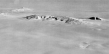
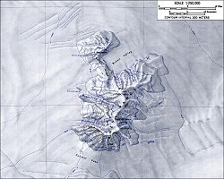
Mount Andrus is a shield volcano
3.2 km (2 mi) SE of Mount Boennighausen
in the SE extremity of Ames Range
, in Marie Byrd Land
, Antarctica. Mapped by USGS from surveys and U.S. Navy air photos, 1964-68. Named by US-ACAN for Lt. Carl H. Andrus, US Navy, medical officer and Officer-in-Charge of Byrd Station
in 1964.
Andrus has a 4.5 km-wide caldera
at its summit. Weak fumarolic
activity was detected in 1977 at Mt. Kaufmann in the northern end of the Ames Range of which Mt. Andrus is the southernmost volcano.
In an interesting side note, Mt. Andrus was reportedly climbed by one Michael J. Andrus (no relation to Carl H. Andrus) in August 2006 for the purpose of downhill skiing, which would make him the first Andrus to visit the mountain (though perhaps not the last). Carl H. Andrus is himself an avid mountain climber, having summited all 46 of the Adirondack range's highest peaks and having in his youth climbed the Matterhorn
for the purpose of skiing down it.
Shield volcano
A shield volcano is a type of volcano usually built almost entirely of fluid lava flows. They are named for their large size and low profile, resembling a warrior's shield. This is caused by the highly fluid lava they erupt, which travels farther than lava erupted from more explosive volcanoes...
3.2 km (2 mi) SE of Mount Boennighausen
Mount Boennighausen
Mount Boennighausen is a snow-covered mountain located 4 nautical miles south-southwest of Mount Kosciusko in the Ames Range of Marie Byrd Land. Mapped by United States Geological Survey from surveys and U.S. Navy air photos, 1959-65. Named by Advisory Committee on Antarctic Names for...
in the SE extremity of Ames Range
Ames Range
The Ames Range is an Antarctic range of snow-covered, flat-topped, steep-sided mountains, extending in a N-S direction for 32 km and forming a right angle with the eastern end of the Flood Range in Marie Byrd Land....
, in Marie Byrd Land
Marie Byrd Land
Marie Byrd Land is the portion of West Antarctica lying east of the Ross Ice Shelf and the Ross Sea and south of the Pacific Ocean, extending eastward approximately to a line between the head of the Ross Ice Shelf and Eights Coast. It stretches between 158°W and 103°24'W...
, Antarctica. Mapped by USGS from surveys and U.S. Navy air photos, 1964-68. Named by US-ACAN for Lt. Carl H. Andrus, US Navy, medical officer and Officer-in-Charge of Byrd Station
Byrd Station
Byrd Station refers to a research station established by the United States during the International Geophysical Year by the U.S. Navy during Operation Deep Freeze II in West Antarctica at 80°, 120°W...
in 1964.
Andrus has a 4.5 km-wide caldera
Caldera
A caldera is a cauldron-like volcanic feature usually formed by the collapse of land following a volcanic eruption, such as the one at Yellowstone National Park in the US. They are sometimes confused with volcanic craters...
at its summit. Weak fumarolic
Fumarole
A fumarole is an opening in a planet's crust, often in the neighborhood of volcanoes, which emits steam and gases such as carbon dioxide, sulfur dioxide, hydrochloric acid, and hydrogen sulfide. The steam is created when superheated water turns to steam as its pressure drops when it emerges from...
activity was detected in 1977 at Mt. Kaufmann in the northern end of the Ames Range of which Mt. Andrus is the southernmost volcano.
In an interesting side note, Mt. Andrus was reportedly climbed by one Michael J. Andrus (no relation to Carl H. Andrus) in August 2006 for the purpose of downhill skiing, which would make him the first Andrus to visit the mountain (though perhaps not the last). Carl H. Andrus is himself an avid mountain climber, having summited all 46 of the Adirondack range's highest peaks and having in his youth climbed the Matterhorn
Matterhorn
The Matterhorn , Monte Cervino or Mont Cervin , is a mountain in the Pennine Alps on the border between Switzerland and Italy. Its summit is 4,478 metres high, making it one of the highest peaks in the Alps. The four steep faces, rising above the surrounding glaciers, face the four compass points...
for the purpose of skiing down it.
External links
- http://usarc.usgs.gov/antarctic_atlas/
- http://www.skimountaineer.com/