
Morialta Conservation Park
Encyclopedia
Morialta Conservation Park is a public reserve 10 km north-east of Adelaide
, in the state of South Australia
, Australia
. The park is in a rugged bush environment, with a narrow gorge set with three waterfall
s, bounded by steep ridges and cliffs. The park caters to many activities, including bush walking, bird watching and rock climbing
.
word meaning "ever flowing" or "running water". The area which is now Morialta Conservation Park was originally acquired by pastoralists in 1839. In 1847, John Baker
bought the land and built the grand Morialta House and Morialta Barns on Fourth Creek, near the head of the gorge. John Smith Reid was also a major landholder in the area, and in 1911, he offered to donate part of his land as a national reserve.
Reid donated 218 hectares (538.7 acre) in 1913, and in 1915 the area was declared a National Pleasure Resort. Much of the construction work in the park was begun in the 1920s and 1930s, although floods and bushfires have destroyed much of this original work. In 1966 additional property to the east was added, and the park was declared a National park. In 1972 the park was re-proclaimed as Morialta Conservation Park.
Major rebuilding was required after flooding in 1980, and flooding in November 2005 again caused damage to paths and walkways.
, which run north-south to the east of Adelaide's coastal plain. It is bounded by Black Hill Conservation Park
on the north, Norton Summit road on the south, the suburb of Rostrevor
on the west, and by agricultural land on the east.
The park lies mostly on either side of Morialta Gorge, along the bottom of which runs Fourth Creek. There are three waterfalls on the creek, named respectively First, Second and Third Falls.
The main access to the park is via the vehicle entrance off Morialta Road, and there is walking access at various points along Norton Summit Road.
Morialta shares Adelaide's Mediterranean climate
, with average temperatures of 17 degrees Celsius in winter, to 28 degrees during summer. The park receives average annual rainfall of 800 mm, mostly between May and September. During summer (December to February) temperatures can rise above 40 degrees.
 Being only 10 km from the centre of Adelaide
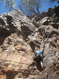
and having a large number of climbs, Morialta is one of the most popular rock climbing areas in South Australia
. The rock is quartzite, and there are heavy duty rings at the top of most routes to allow for easy top-roping.
There are several crags along both sides of the gorge. On the southern side, from the western end, there is Milestone Buttress, The Outcrops, The Buttress, Billiard Table, Boulder Bridge, Throne Room and Far Crag. On the northern side there is The Lost Walls and Thorn Buttress. Far Crag is one of the more popular crags, with over 67 routes graded from 4 (Ewbanks
) to 27.
A large number of routes were put up at the park up until the 1970s. A visit by international climbers in 1971 saw the standards of free climbing increase at the park, with many new bold routes being led. The late 70's saw grades at the park reach 25.
Remarkably, The Lost Walls were not discovered until 1986, hence their name and is the most recent addition of a significant number of climbs. 1994 saw the highest graded new route put up in the park, at 27. Access is now from Norton Summit Road, on the southern side of the park.
, which is made especially easy by the provision of regularly tested steel rings at the tops of many climbs. These rings greatly simplify the task of building an anchor, making outdoor climbing accessible to a broader range of people.
Although most routes can be top-roped, there are routes which are bolted for sport climbing
, or suitable for traditional climbing
with natural gear, or a mixture of both. Often a route which is suitable for sport or traditional climbing can also be top-roped.
Adelaide
Adelaide is the capital city of South Australia and the fifth-largest city in Australia. Adelaide has an estimated population of more than 1.2 million...
, in the state of South Australia
South Australia
South Australia is a state of Australia in the southern central part of the country. It covers some of the most arid parts of the continent; with a total land area of , it is the fourth largest of Australia's six states and two territories.South Australia shares borders with all of the mainland...
, Australia
Australia
Australia , officially the Commonwealth of Australia, is a country in the Southern Hemisphere comprising the mainland of the Australian continent, the island of Tasmania, and numerous smaller islands in the Indian and Pacific Oceans. It is the world's sixth-largest country by total area...
. The park is in a rugged bush environment, with a narrow gorge set with three waterfall
Waterfall
A waterfall is a place where flowing water rapidly drops in elevation as it flows over a steep region or a cliff.-Formation:Waterfalls are commonly formed when a river is young. At these times the channel is often narrow and deep. When the river courses over resistant bedrock, erosion happens...
s, bounded by steep ridges and cliffs. The park caters to many activities, including bush walking, bird watching and rock climbing
Climbing
Climbing is the activity of using one's hands and feet to ascend a steep object. It is done both for recreation and professionally, as part of activities such as maintenance of a structure, or military operations.Climbing activities include:* Bouldering: Ascending boulders or small...
.
History
Morialta derives its name from a KaurnaKaurna language
"Kaurna" is the language of the Kaurna people, an Australian aboriginal ethnic group, in South Australia. It was historically spoken on the Adelaide Plains from Crystal Brook and Clare in the north, to Cape Jervis in the south. It became extinct in the 19th century but was revived and reconstructed...
word meaning "ever flowing" or "running water". The area which is now Morialta Conservation Park was originally acquired by pastoralists in 1839. In 1847, John Baker
John Baker (Australian politician)
John Baker was an early South Australian pastoralist and politician. He was the second Premier of South Australia, succeeding Boyle Finniss; however, he only held office for 12 days from 21 August to 1 September 1857 before being succeeded by the third Premier of the colony, Robert Torrens.-Early...
bought the land and built the grand Morialta House and Morialta Barns on Fourth Creek, near the head of the gorge. John Smith Reid was also a major landholder in the area, and in 1911, he offered to donate part of his land as a national reserve.
Reid donated 218 hectares (538.7 acre) in 1913, and in 1915 the area was declared a National Pleasure Resort. Much of the construction work in the park was begun in the 1920s and 1930s, although floods and bushfires have destroyed much of this original work. In 1966 additional property to the east was added, and the park was declared a National park. In 1972 the park was re-proclaimed as Morialta Conservation Park.
Major rebuilding was required after flooding in 1980, and flooding in November 2005 again caused damage to paths and walkways.
Geography and climate
Morialta Conservation Park covers 5.33 km² within the Mount Lofty RangesMount Lofty Ranges
The Mount Lofty Ranges are the range of mountains just to the east of Adelaide in South Australia.-Location and description:The Mount Lofty Ranges stretch from the southernmost point of the Fleurieu Peninsula at Cape Jervis northwards for over before petering out north of Peterborough...
, which run north-south to the east of Adelaide's coastal plain. It is bounded by Black Hill Conservation Park
Black Hill Conservation Park
Black Hill Conservation Park is a public reserve approximately 10 km northeast of Adelaide, in the state of South Australia, Australia. The park is in a rugged bush environment, with a prominent peak, bounded by steep ridges on the southern slopes...
on the north, Norton Summit road on the south, the suburb of Rostrevor
Rostrevor, South Australia
Rostrevor is a suburb of Adelaide within the City of Campbelltown and the Adelaide Hills Council. It is located about 10 kilometres east-north-east of the Adelaide city centre....
on the west, and by agricultural land on the east.
The park lies mostly on either side of Morialta Gorge, along the bottom of which runs Fourth Creek. There are three waterfalls on the creek, named respectively First, Second and Third Falls.
The main access to the park is via the vehicle entrance off Morialta Road, and there is walking access at various points along Norton Summit Road.
Morialta shares Adelaide's Mediterranean climate
Mediterranean climate
A Mediterranean climate is the climate typical of most of the lands in the Mediterranean Basin, and is a particular variety of subtropical climate...
, with average temperatures of 17 degrees Celsius in winter, to 28 degrees during summer. The park receives average annual rainfall of 800 mm, mostly between May and September. During summer (December to February) temperatures can rise above 40 degrees.
Activities
The park caters for a variety of activities, including bush walking, picnics, rock climbing and bird watching. There are many walking paths within the park.Rock Climbing
Adelaide
Adelaide is the capital city of South Australia and the fifth-largest city in Australia. Adelaide has an estimated population of more than 1.2 million...
and having a large number of climbs, Morialta is one of the most popular rock climbing areas in South Australia
South Australia
South Australia is a state of Australia in the southern central part of the country. It covers some of the most arid parts of the continent; with a total land area of , it is the fourth largest of Australia's six states and two territories.South Australia shares borders with all of the mainland...
. The rock is quartzite, and there are heavy duty rings at the top of most routes to allow for easy top-roping.
There are several crags along both sides of the gorge. On the southern side, from the western end, there is Milestone Buttress, The Outcrops, The Buttress, Billiard Table, Boulder Bridge, Throne Room and Far Crag. On the northern side there is The Lost Walls and Thorn Buttress. Far Crag is one of the more popular crags, with over 67 routes graded from 4 (Ewbanks
John Ewbank (climber)
John Ewbank was born in Yorkshire, England in 1948, and emigrated to Australia at age 15. Having learned rockclimbing in his native country, he quickly became involved in the fledgling Australian rockclimbing scene, and went on to pioneer hundreds of new routes on crags around the country,...
) to 27.
History
The first climbing at Morialta was in 1962 by a group from the Adelaide University Mountain Club (AUMC). Four members of the club were given an introduction by the National Fitness Council and began regular climbing at the site. Access at this time was from the western end of the park (the Adelaide side) and so the cliffs to the western end were climbed first. No documentation of the climbing occurred until 1968, when Far Crag was discovered. It was named such because it is the furthest from the western end and so had the longest walk to reach it.A large number of routes were put up at the park up until the 1970s. A visit by international climbers in 1971 saw the standards of free climbing increase at the park, with many new bold routes being led. The late 70's saw grades at the park reach 25.
Remarkably, The Lost Walls were not discovered until 1986, hence their name and is the most recent addition of a significant number of climbs. 1994 saw the highest graded new route put up in the park, at 27. Access is now from Norton Summit Road, on the southern side of the park.
Style of climbing
The highest volume of climbing in the gorge is done on top ropeTop roping
Top-rope climbing is a style in climbing in which a rope, used for the climber's safety, runs from a belayer at the foot of a route through one or more carabiners connected to an anchor system at the top of the route and back down to the climber, usually attaching to the climber by means of a...
, which is made especially easy by the provision of regularly tested steel rings at the tops of many climbs. These rings greatly simplify the task of building an anchor, making outdoor climbing accessible to a broader range of people.
Although most routes can be top-roped, there are routes which are bolted for sport climbing
Sport climbing
Sport climbing is a form of rock climbing that relies on permanent anchors fixed to the rock, and possibly bolts, for protection,...
, or suitable for traditional climbing
Traditional climbing
Traditional climbing, or trad climbing, is a style of rock climbing in which a climber or group of climbers places all gear required to protect against falls , and removes it when a passage is complete...
with natural gear, or a mixture of both. Often a route which is suitable for sport or traditional climbing can also be top-roped.