
Moravian Falls, North Carolina
Encyclopedia
Moravian Falls is a census-designated place
(CDP) in Wilkes County
, North Carolina
, United States
. The population was 1,440 as of the 2000 census.
, the CDP has a total area of 5.1 square miles (13.2 km²), of which, 5.1 square miles (13.2 km²) of it is land and 0.20% is water.
in the foothills of the Brushy Mountains
, which rise just 2 to 3 miles (4.8 km) to the south of the community. Pores Knob
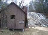
, the highest peak in the Brushy Mountains, is located in Moravian Falls. The area was originally settled by members of the Moravian Church in 1753, and Moravians owned the waterfall for many years (the waterfall is named after the church). Today the waterfall is a tourist attraction owned by Ken Wike who operates a history rich family campground(Moravian Falls Family Campground). People travel from all over the U.S. to enjoy the peaceful beauty of nature. Wilkes Central High School
, and Central Wilkes Middle School, are located in the community. The two schools are the largest and most ethnically diverse high school and middle school respectively in all of Wilkes County.
of 2000, there were 1,440 people, 600 households, and 415 families residing in the CDP. The population density
was 283.0 people per square mile (109.2/km²). There were 656 housing units at an average density of 128.9 per square mile (49.8/km²). The racial makeup of the CDP was 89.58% White, 5.49% African American, 0.14% Asian, 3.47% from other races
, and 1.32% from two or more races. Hispanic or Latino of any race were 7.15% of the population.
There were 600 households out of which 26.2% had children under the age of 18 living with them, 55.5% were married couples
living together, 10.2% had a female householder with no husband present, and 30.7% were non-families. 26.5% of all households were made up of individuals and 7.7% had someone living alone who was 65 years of age or older. The average household size was 2.39 and the average family size was 2.86.
In the CDP the population was spread out with 22.0% under the age of 18, 9.1% from 18 to 24, 29.0% from 25 to 44, 25.8% from 45 to 64, and 14.1% who were 65 years of age or older. The median age was 38 years. For every 100 females there were 97.8 males. For every 100 females age 18 and over, there were 97.7 males.
The median income for a household in the CDP was $36,607, and the median income for a family was $48,906. Males had a median income of $21,911 versus $24,013 for females. The per capita income
for the CDP was $19,405. About 5.7% of families and 12.4% of the population were below the poverty line, including 18.1% of those under age 18 and 13.3% of those age 65 or over.
Census-designated place
A census-designated place is a concentration of population identified by the United States Census Bureau for statistical purposes. CDPs are delineated for each decennial census as the statistical counterparts of incorporated places such as cities, towns and villages...
(CDP) in Wilkes County
Wilkes County, North Carolina
Wilkes County is a county located in the U.S. state of North Carolina. The 2000 U.S. Census listed the county's population at 65,632; the 2010 U.S. Census listed the population at 69,340...
, North Carolina
North Carolina
North Carolina is a state located in the southeastern United States. The state borders South Carolina and Georgia to the south, Tennessee to the west and Virginia to the north. North Carolina contains 100 counties. Its capital is Raleigh, and its largest city is Charlotte...
, United States
United States
The United States of America is a federal constitutional republic comprising fifty states and a federal district...
. The population was 1,440 as of the 2000 census.
Geography
Moravian Falls is located at 36°6′22"N 81°10′34"W (36.106113, -81.176105). According to the United States Census BureauUnited States Census Bureau
The United States Census Bureau is the government agency that is responsible for the United States Census. It also gathers other national demographic and economic data...
, the CDP has a total area of 5.1 square miles (13.2 km²), of which, 5.1 square miles (13.2 km²) of it is land and 0.20% is water.
Background
Moravian Falls takes its name from a waterfallMoravian Falls
Moravian Falls is a waterfall in Wilkes County, North Carolina.-Geology:The waterfall is located on Moravian Creek, where it flows over a large bedrock to a lower plunge pool.-Natural history:...
in the foothills of the Brushy Mountains
Brushy Mountains (North Carolina)
The Brushy Mountains are a mountain range located in northwestern North Carolina. They are an isolated "spur" of the much larger Blue Ridge Mountains, separated from them by the Yadkin River valley...
, which rise just 2 to 3 miles (4.8 km) to the south of the community. Pores Knob
Pores Knob
-Physical features:Pores Knob is the highest point of the Brushy Mountains chain. The Brushy Mountains are a deeply eroded spur of the much larger Blue Ridge Mountains...
, the highest peak in the Brushy Mountains, is located in Moravian Falls. The area was originally settled by members of the Moravian Church in 1753, and Moravians owned the waterfall for many years (the waterfall is named after the church). Today the waterfall is a tourist attraction owned by Ken Wike who operates a history rich family campground(Moravian Falls Family Campground). People travel from all over the U.S. to enjoy the peaceful beauty of nature. Wilkes Central High School
Wilkes Central High School
Wilkes Central High School is a public high school located in Moravian Falls, North Carolina. It is a part of the Wilkes County School System. The school's enrollment is typically around 1,000 students. The school's district includes the towns of Wilkesboro and North Wilkesboro as well as the...
, and Central Wilkes Middle School, are located in the community. The two schools are the largest and most ethnically diverse high school and middle school respectively in all of Wilkes County.
Demographics
As of the censusCensus
A census is the procedure of systematically acquiring and recording information about the members of a given population. It is a regularly occurring and official count of a particular population. The term is used mostly in connection with national population and housing censuses; other common...
of 2000, there were 1,440 people, 600 households, and 415 families residing in the CDP. The population density
Population density
Population density is a measurement of population per unit area or unit volume. It is frequently applied to living organisms, and particularly to humans...
was 283.0 people per square mile (109.2/km²). There were 656 housing units at an average density of 128.9 per square mile (49.8/km²). The racial makeup of the CDP was 89.58% White, 5.49% African American, 0.14% Asian, 3.47% from other races
Race (United States Census)
Race and ethnicity in the United States Census, as defined by the Federal Office of Management and Budget and the United States Census Bureau, are self-identification data items in which residents choose the race or races with which they most closely identify, and indicate whether or not they are...
, and 1.32% from two or more races. Hispanic or Latino of any race were 7.15% of the population.
There were 600 households out of which 26.2% had children under the age of 18 living with them, 55.5% were married couples
Marriage
Marriage is a social union or legal contract between people that creates kinship. It is an institution in which interpersonal relationships, usually intimate and sexual, are acknowledged in a variety of ways, depending on the culture or subculture in which it is found...
living together, 10.2% had a female householder with no husband present, and 30.7% were non-families. 26.5% of all households were made up of individuals and 7.7% had someone living alone who was 65 years of age or older. The average household size was 2.39 and the average family size was 2.86.
In the CDP the population was spread out with 22.0% under the age of 18, 9.1% from 18 to 24, 29.0% from 25 to 44, 25.8% from 45 to 64, and 14.1% who were 65 years of age or older. The median age was 38 years. For every 100 females there were 97.8 males. For every 100 females age 18 and over, there were 97.7 males.
The median income for a household in the CDP was $36,607, and the median income for a family was $48,906. Males had a median income of $21,911 versus $24,013 for females. The per capita income
Per capita income
Per capita income or income per person is a measure of mean income within an economic aggregate, such as a country or city. It is calculated by taking a measure of all sources of income in the aggregate and dividing it by the total population...
for the CDP was $19,405. About 5.7% of families and 12.4% of the population were below the poverty line, including 18.1% of those under age 18 and 13.3% of those age 65 or over.