
Mono Cliffs Provincial Park
Encyclopedia
Mono Cliffs Provincial Park lies just outside the town of Mono
, in southern-Ontario
, Canada
, along the Bruce Trail
. It is part of the Niagara Escarpment
Parks System, and the escarpment Biosphere Reserve
.
There is a map of the park and the seven colour coded trails:
The map also indicates how each section of the trail can be used:
Also along the Cliff Top Trail is a viewing platform that extends out over the cliff edge, with a great view to the north east across the park to the farms beyond.
Large Outliers: There are two large 'outliers' that have been separated from the main escarpment edge.
Water features:
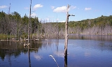
In the north west corner of the park is McCarston's Lake. There are also a number of streams and smaller ponds throughout the park,
the largest just below the viewing platform.
Mono, Ontario
The Town of Mono is situated in south-central Ontario, Canada, at the south-east corner of County of Dufferin, just north of Caledon and northeast of Orangeville. It stretches from Highway 9 along its southern border to Highway 89 along its northern border. Its border to the west is with the...
, in southern-Ontario
Ontario
Ontario is a province of Canada, located in east-central Canada. It is Canada's most populous province and second largest in total area. It is home to the nation's most populous city, Toronto, and the nation's capital, Ottawa....
, Canada
Canada
Canada is a North American country consisting of ten provinces and three territories. Located in the northern part of the continent, it extends from the Atlantic Ocean in the east to the Pacific Ocean in the west, and northward into the Arctic Ocean...
, along the Bruce Trail
Bruce Trail
The Bruce Trail is a hiking trail in southern and central Ontario, Canada.-General:The trail follows the edge of the Niagara Escarpment, one of the thirteen UNESCO World Biosphere Reserves in Canada, for almost...
. It is part of the Niagara Escarpment
Niagara Escarpment
The Niagara Escarpment is a long escarpment, or cuesta, in the United States and Canada that runs westward from New York State, through Ontario, Michigan, Wisconsin and Illinois...
Parks System, and the escarpment Biosphere Reserve
Biosphere reserve
The Man and the Biosphere Programme of UNESCO was established in 1971 to promote interdisciplinary approaches to management, research and education in ecosystem conservation and sustainable use of natural resources.-Development:...
.
Main entrance
The main entrance to the park is located along the 3rd Line E.H.S. at a pay parking lot with washrooms.There is a map of the park and the seven colour coded trails:
- Carriage Trail (red)
- Spillway Trail (blue)
- Cliff Top Trail (green)
- McCarston's Lake (orange)
- South Outlier Trail (yellow)
- Lookout Trail (grey)
- Bruce Trail (dotted)
The map also indicates how each section of the trail can be used:
- hiking
- biking
- horseback riding
Natural features
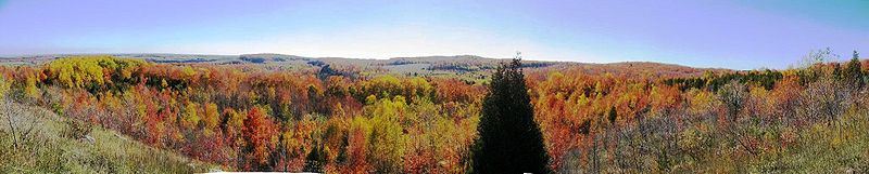
Rock faces: As the name suggests, the park has a number of cliff faces along the Niagara Escarpment itself. Along the Cliff Top Trail is a sturdy set of stairs which descend about 30m down the rock face to a wooden path that runs between the cliff face and a small outlier, providing excellent views of the rock, ferns, and cedars. Caving, rock climbing, bouldering, and scrambling are not permitted anywhere in the park.Also along the Cliff Top Trail is a viewing platform that extends out over the cliff edge, with a great view to the north east across the park to the farms beyond.
Large Outliers: There are two large 'outliers' that have been separated from the main escarpment edge.
Water features:
In the north west corner of the park is McCarston's Lake. There are also a number of streams and smaller ponds throughout the park,
the largest just below the viewing platform.