
Monarch Pass
Encyclopedia
Monarch Pass is a high mountain pass
in the Rocky Mountains
of south-central Colorado
in the United States
.
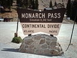
 The pass is located on the continental divide
at the southern end of the Sawatch Range
along the border between Gunnison
and Chaffee
counties, approximately 25 miles (40 km) west of the town of Salida
. The pass carries U.S. Highway 50 over the Sawatch Range, providing a route between Tomichi Creek
in the upper basin of the Gunnison River
on the west and the South Arkansas River
, a tributary of the Arkansas River
on the east. The pass is traversable by all vehicles under most conditions and is generally open year-round, however 7% grades exist. It is prone to heavy winter snowfall however, and is often temporarily closed in heavy winter storms. Ramps for runaway trucks are located about halfway down both the eastern and western sides of the pass.
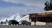
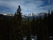
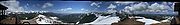
The pass is widely considered one of the most scenic in Colorado, offering a panoramic view of the southern end of the Sawatch Range from the summit. A gift shop and small restaurant are located near the summit of the pass. During the summer, an aerial tram from the parking lot at the summit carries visitors to the top of Monarch Ridge above the pass (at approximately 12000 feet (3,657.6 m) above sea level), allowing a wider view of the surrounding peaks. During the winter, visitors enjoy skiing at Monarch ski area
.
Old Monarch Pass connects to Monarch Pass at two points. Old Monarch Pass is traversable by passenger vehicles at most times during the summer and early fall months. However, heavy rainfalls occasionally wash out the east entrance to the pass. Check with a local ranger station for current conditions.
An automated weather station (AWOS), provided by the Federal Aviation Administration
, is located atop Monarch Pass, broadcasting at 124.175 mHz, providing pilots of small aircraft access to real-time weather conditions near the summit. The high terrain and frequent storms, however, make this route problematic for light aircraft; the pass is steep and narrow, especially when approached from the east, with a sharp turn required at the summit. Aircraft accidents in the vicinity of Monarch pass are frequent. Many Colorado pilots suggest small aircraft avoid Monarch and, whenever possible, make use of the lower, flatter, Marshall Pass just a few miles to the south.
Mountain pass
A mountain pass is a route through a mountain range or over a ridge. If following the lowest possible route, a pass is locally the highest point on that route...
in the Rocky Mountains
Rocky Mountains
The Rocky Mountains are a major mountain range in western North America. The Rocky Mountains stretch more than from the northernmost part of British Columbia, in western Canada, to New Mexico, in the southwestern United States...
of south-central Colorado
Colorado
Colorado is a U.S. state that encompasses much of the Rocky Mountains as well as the northeastern portion of the Colorado Plateau and the western edge of the Great Plains...
in the United States
United States
The United States of America is a federal constitutional republic comprising fifty states and a federal district...
.
Continental divide
A continental divide is a drainage divide on a continent such that the drainage basin on one side of the divide feeds into one ocean or sea, and the basin on the other side either feeds into a different ocean or sea, or else is endorheic, not connected to the open sea...
at the southern end of the Sawatch Range
Sawatch Range
The Sawatch Range is a mountain range in central Colorado which includes eight of the twenty highest peaks in the Rocky Mountains, including Mount Elbert, at elevation, the highest peak in the Rockies....
along the border between Gunnison
Gunnison County, Colorado
Gunnison County is the fifth most extensive of the 64 counties of the state of Colorado in the United States. The county population was 15,324 at the 2010 census. The county was named for John W. Gunnison, a United States Army officer and captain in the Army Topographical Engineers, who surveyed...
and Chaffee
Chaffee County, Colorado
Chaffee County is one of the 64 counties of the state of Colorado of the United States. The county population was 16,242 at U.S. Census 2000. The county seat is Salida.-History:...
counties, approximately 25 miles (40 km) west of the town of Salida
Salida, Colorado
The City of Salida is a Statutory City that is the county seat and most populous city of Chaffee County, Colorado, United States. The population was 5,504 at the U.S. Census 2000.-History:800px|thumb|left| Panoramic View of Salida, 1910...
. The pass carries U.S. Highway 50 over the Sawatch Range, providing a route between Tomichi Creek
Tomichi Creek
Tomichi Creek is a tributary of the Gunnison River in Gunnison County, Colorado....
in the upper basin of the Gunnison River
Gunnison River
The Gunnison River is a tributary of the Colorado River, long, in the Southwest state of Colorado. It is the fifth largest tributary of the Colorado River, with a mean flow of 4320 ft³/s .-Description:...
on the west and the South Arkansas River
South Arkansas River
South Arkansas River is a tributary of the Arkansas River that flows from a source near Monarch Pass in the Sawatch Range of southern Colorado. It joins the Arkansas just south of Salida, Colorado....
, a tributary of the Arkansas River
Arkansas River
The Arkansas River is a major tributary of the Mississippi River. The Arkansas generally flows to the east and southeast as it traverses the U.S. states of Colorado, Kansas, Oklahoma, and Arkansas. The river's initial basin starts in the Western United States in Colorado, specifically the Arkansas...
on the east. The pass is traversable by all vehicles under most conditions and is generally open year-round, however 7% grades exist. It is prone to heavy winter snowfall however, and is often temporarily closed in heavy winter storms. Ramps for runaway trucks are located about halfway down both the eastern and western sides of the pass.
The pass is widely considered one of the most scenic in Colorado, offering a panoramic view of the southern end of the Sawatch Range from the summit. A gift shop and small restaurant are located near the summit of the pass. During the summer, an aerial tram from the parking lot at the summit carries visitors to the top of Monarch Ridge above the pass (at approximately 12000 feet (3,657.6 m) above sea level), allowing a wider view of the surrounding peaks. During the winter, visitors enjoy skiing at Monarch ski area
Monarch Ski Area
Monarch Ski and Snowboard Area is located on U.S. Highway 50. It is twenty miles west of Salida, Colorado, on Monarch Pass and has 54 trails, two terrain parks, and a newly-opened Extreme-Terrain area called Mirkwood. The Monarch Mountain Lodge is located three miles east of the ski area in the...
.
Old Monarch Pass connects to Monarch Pass at two points. Old Monarch Pass is traversable by passenger vehicles at most times during the summer and early fall months. However, heavy rainfalls occasionally wash out the east entrance to the pass. Check with a local ranger station for current conditions.
An automated weather station (AWOS), provided by the Federal Aviation Administration
Federal Aviation Administration
The Federal Aviation Administration is the national aviation authority of the United States. An agency of the United States Department of Transportation, it has authority to regulate and oversee all aspects of civil aviation in the U.S...
, is located atop Monarch Pass, broadcasting at 124.175 mHz, providing pilots of small aircraft access to real-time weather conditions near the summit. The high terrain and frequent storms, however, make this route problematic for light aircraft; the pass is steep and narrow, especially when approached from the east, with a sharp turn required at the summit. Aircraft accidents in the vicinity of Monarch pass are frequent. Many Colorado pilots suggest small aircraft avoid Monarch and, whenever possible, make use of the lower, flatter, Marshall Pass just a few miles to the south.
External links
- Current road and ski conditions
- Topographic map from USGS via Microsoft Research Maps