
Moenkopi, Arizona
Encyclopedia
Moenkopi is a census-designated place
(CDP) in Coconino County, Arizona
, United States, adjacent to the southeast side of Tuba City
off U.S. Route 160
. The population was 901 at the 2000 census.
A Hopi
community, it was founded in 1870 as a summer farming area by people from the Hopi Third Mesa village of Oraibi, Arizona. It is forty miles west of Third Mesa and is divided into the villages of Upper Moenkopi and Lower Moenkopi. It lies in a 250.306 km² (96.6 sq mi) exclave of the Hopi Indian Reservation
which is separated from the main part of the reservation which lies to the east. Both parts are surrounded by Navajo Indian Reservation territory. The smaller section comprises only 3.8 percent of the Hopi Reservation's land area and 13.2 percent (916 persons) of its population.
According to the United States Census Bureau
, the CDP has a total area of 1.6 square miles (4.1 km²), all land.
is 561.9 people per square mile (217.4/km²). There are 284 housing units at an average density of 177.1/sq mi (68.5/km²). The racial makeup of the CDP was 96.67% Native American, 1.66% from two or more races, 1.44% White, 0.22% from other races, and Hispanic or Latino of any race were 0.78% of the population.
There were 242 households out of which 36.8% had children under the age of 18 living with them, 46.7% were married couples living together, 28.9% had a female householder with no husband present, and 16.5% were non-families. 14.0% of all households were made up of individuals and 5.8% had someone living alone who was 65 years of age or older. The average household size was 3.72 and the average family size was 4.06.
In the CDP the age distribution of the population shows 35.2% under the age of 18, 9.4% from 18 to 24, 23.1% from 25 to 44, 20.0% from 45 to 64, and 12.3% who were 65 years of age or older. The median age was 31 years. For every 100 females there were 96.7 males. For every 100 females age 18 and over, there were 89.0 males.
The median income for a household in the CDP was $38,710, and the median income for a family was $38,266. Males had a median income of $49,063 versus $28,409 for females. The per capita income
for the CDP was $11,432. About 15.6% of families and 13.8% of the population were below the poverty line, including 15.8% of those under the age of 18 and 4.5% of those 65 and older.
Census-designated place
A census-designated place is a concentration of population identified by the United States Census Bureau for statistical purposes. CDPs are delineated for each decennial census as the statistical counterparts of incorporated places such as cities, towns and villages...
(CDP) in Coconino County, Arizona
Coconino County, Arizona
-2010:Whereas according to the 2010 U.S. Census Bureau:*61.7% White*1.2% Black*27.3% Native American*1.4% Asian*0.1% Native Hawaiian or Pacific Islander*3.1% Two or more races*5.2% Other races*13.5% Hispanic or Latino -2000:...
, United States, adjacent to the southeast side of Tuba City
Tuba City, Arizona
Tuba City is a census-designated place in Coconino County, Arizona, United States. The population was 8,225 at the 2000 census. It is the Dine' Nation's largest community, slightly larger than Shiprock, New Mexico. The Hopi town of Moenkopi lies directly to its southeast.The name of the town...
off U.S. Route 160
U.S. Route 160
U.S. Route 160 is a 1,465 mile long east–west United States highway in the Midwestern United States. The western terminus of the route is at U.S. Route 89 five miles west of Tuba City, Arizona. The eastern terminus is at U.S...
. The population was 901 at the 2000 census.
A Hopi
Hopi
The Hopi are a federally recognized tribe of indigenous Native American people, who primarily live on the Hopi Reservation in northeastern Arizona. The Hopi area according to the 2000 census has a population of 6,946 people. Their Hopi language is one of the 30 of the Uto-Aztecan language...
community, it was founded in 1870 as a summer farming area by people from the Hopi Third Mesa village of Oraibi, Arizona. It is forty miles west of Third Mesa and is divided into the villages of Upper Moenkopi and Lower Moenkopi. It lies in a 250.306 km² (96.6 sq mi) exclave of the Hopi Indian Reservation
Hopi Reservation
The Hopi Reservation, or simply Hopi, is a Native American reservation for the Hopi and Arizona Tewa people, surrounded entirely by the Navajo Nation, in Navajo and Coconino counties of Arizona, USA. The site in north-eastern Arizona has a land area of 2,531.773 sq mi and as of the 2000 census had...
which is separated from the main part of the reservation which lies to the east. Both parts are surrounded by Navajo Indian Reservation territory. The smaller section comprises only 3.8 percent of the Hopi Reservation's land area and 13.2 percent (916 persons) of its population.
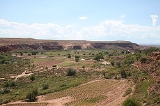
Geography
Located in the center of a wide valley, Moenkopi is located at 36°6′42"N 111°13′15"W (36.111741, -111.220699).According to the United States Census Bureau
United States Census Bureau
The United States Census Bureau is the government agency that is responsible for the United States Census. It also gathers other national demographic and economic data...
, the CDP has a total area of 1.6 square miles (4.1 km²), all land.
Demographics
As of the census of 2000, there were 901 people, 242 households, and 202 families residing in the CDP. The population densityPopulation density
Population density is a measurement of population per unit area or unit volume. It is frequently applied to living organisms, and particularly to humans...
is 561.9 people per square mile (217.4/km²). There are 284 housing units at an average density of 177.1/sq mi (68.5/km²). The racial makeup of the CDP was 96.67% Native American, 1.66% from two or more races, 1.44% White, 0.22% from other races, and Hispanic or Latino of any race were 0.78% of the population.
There were 242 households out of which 36.8% had children under the age of 18 living with them, 46.7% were married couples living together, 28.9% had a female householder with no husband present, and 16.5% were non-families. 14.0% of all households were made up of individuals and 5.8% had someone living alone who was 65 years of age or older. The average household size was 3.72 and the average family size was 4.06.
In the CDP the age distribution of the population shows 35.2% under the age of 18, 9.4% from 18 to 24, 23.1% from 25 to 44, 20.0% from 45 to 64, and 12.3% who were 65 years of age or older. The median age was 31 years. For every 100 females there were 96.7 males. For every 100 females age 18 and over, there were 89.0 males.
The median income for a household in the CDP was $38,710, and the median income for a family was $38,266. Males had a median income of $49,063 versus $28,409 for females. The per capita income
Per capita income
Per capita income or income per person is a measure of mean income within an economic aggregate, such as a country or city. It is calculated by taking a measure of all sources of income in the aggregate and dividing it by the total population...
for the CDP was $11,432. About 15.6% of families and 13.8% of the population were below the poverty line, including 15.8% of those under the age of 18 and 4.5% of those 65 and older.
External links
- Web page for the villages from the Hopi Tribe website
- Moenkopi, Census Tract 9412, Hopi Reservation, Arizona United States Census Bureau