

Minneapolis Streetcar System
Encyclopedia
The Minneapolis Streetcar System is a proposed streetcar system for the city of Minneapolis, Minnesota
. Extensive studies and plans for the new system were completed in 2007 and presented to the Minneapolis City Council
in January 2008; on April 2, 2010, the Council voted to approve the plans and seek funding. On December 21, 2010 the Federal Transit Administration granted $900,000 to further study the Nicollet and Central Avenue corridors.
) streetcars are rarely separated from other traffic and are not given traffic-signal priority over other vehicles (like Light rail
), except in a few situations to allow the rail cars—which cannot turn as sharply as other most motor vehicles—to make some turns. In Portland, using this "mixed traffic" operation has reduced the cost of constructing each segment and—by not closing traffic lanes permanently to other traffic, as is typically done with light rail—also minimized disruption to traffic flow, and allowed curbside parking to be retained, but also means slower operating speeds compared to light rail. Additional factors making the Portland Streetcar line less expensive to build per mile than light rail are that use of city streets largely eliminated the need to acquire private property for portions of the right-of-way, as has been necessary for the region's light rail lines, and that the vehicles' smaller size and therefore lighter weight has enabled the use of a "shallower track slab". The latter means that construction of the trackway necessitated excavating to a depth of only 12.2 inches (310 mm) instead of the conventional (for light rail) depth of around 18.3 inches (460 mm), significantly reducing the extent to which previously existing underground utilities had to be relocated to accommodate the trackway.
s from Newark City Subway. Click to view an example of the Portland streetcar vehicles Vehicle image one Vehicle image two
Use of Nextrip signs would also be used at the stations, to allow riders to determine the time of the next arriving train or bus at the station. The streetcars would be operated by Metro Transit
a division of the Metropolitan Council.
line follow former Twin City Rapid Transit
streetcar routes that were ripped up out of the ground in the early 1950s.
It appears as if the Central Line combined with the Nicollet Ave./Mall Line is the most promising line to be built, due to its importance in helping revitalize both North and South Minneapolis
) from the Nicollet Avenue/Mall Line in Downtown Minneapolis to the Columbia Heights Transit Center in Columbia Heights, Minnesota
. The line would cross the Mississippi River
via the Third Avenue Bridge
. There is an at-grade railroad crossing at 36th Avenue NE that would have to be altered to ensure steady traffic flow for the streetcars. Other than the railroad crossing, there are no major construction or engineering issues along the corridor.
The total length of the line would be 9.6 miles (15.4 km). The cost of track for the line would be approximately $100,000,000. Ridership estimates for the line are around 5,500 to 7,000 weekday riders.
Combined with the Nicollet Avenue/Nicollet Mall Line (current proposed action) the total length would be approximately 9.6 miles and a total combined cost of $185,000,000. Travel time from the I35W & 46th St. Bus Rapid Transit (BRT) Station to the Columbia Heights Transit Center would be approximately 35 minutes. Estimated ridership for the combination of the two lines would be 14,500-17,500 riders per weekday. Compared to the 30,500 riders per weekday on the 12.3 Mile Hiawatha Light Rail Line from Target Field
in Downtown Minneapolis to Mall of America
.
The route follows the northern leg of TCRT's Bloomington–Columbia Heights line.
and Nicollet Mall
from 46th Street South through Downtown Minneapolis (connecting to the Hiawatha Line
at Nicollet Mall Station) to the Central Avenue Line.
The line would be 4.1 miles long. The track would cost approximately $85,000,000. Ridership estimates for the line are approximately 10,000 to 12,000 weekday riders.
Combined with the Central Avenue Line (current proposed action) the total length would be approximately 9.6 miles and a total combined cost of $185,000,000. Travel time from the I35W & 46th St. Bus Rapid Transit (BRT) Station to the Columbia Heights Transit Center would be approximately 35 minutes. Estimated ridership for the combination of the two lines would be 14,500-17,500 riders per weekday. Compared to the 30,500 riders per weekday on the 12.3 Mile Hiawatha Light Rail Line from Target Field
in Downtown Minneapolis to Mall of America
.
The route follows the southern leg of TCRT's Nicollet–Northwest line.
Although TCRT streetcars never ran along the rail corridor that is now the Midtown Greenway
, the Minneapolis leg of the Selby-Lake line ran one block south on Lake Street.
from the Robbinsdale Transit Center to ether Nicollet Mall
and 5th Street or Park Avenue and 5th Street in Downtown Minneapolis, depending on the final configuration.
The line would be 11.4 miles long. The track would cost approximately $135,000,000. Estimated ridership for the line would be approximately 4,500 to 5,500 weekday riders.
The route follows TCRT's 28th Ave.–Robbinsdale line.
from the Uptown Transit Center through Downtown Minneapolis (connecting with the Hiawatha Line
at Warehouse District / Hennepin Avenue Station) to the University of Minnesota
's East Bank, at which point it would become the University/4th Street Line. The line would cross the Mississippi River
on the Hennepin Avenue Bridge
.
The line would be 3.9 miles long. The track would cost approximately $80,000,000. Ridership estimates for the line are approximately 9,500 to 12,000 weekday riders. (This includes the University/4th Street Line also.)
The route follows a portion of the southern leg of TCRT's Oak–Harriet line.
in Downtown Minneapolis via 9th and 10th streets. The line would then run along Nicollet Mall
to 5th Street. It would terminate at Nicollet Mall Station on the Hiawatha Line
.
The line would be 3 miles (4.8 km) long. The cost of track for the line would be approximately $80,000,000. Ridership estimates for this line are approximately 11,000 to 13,000 riders on weekdays.
The route follows the southern leg of TCRT's Chicago–Penn line.
Minneapolis, Minnesota
Minneapolis , nicknamed "City of Lakes" and the "Mill City," is the county seat of Hennepin County, the largest city in the U.S. state of Minnesota, and the 48th largest in the United States...
. Extensive studies and plans for the new system were completed in 2007 and presented to the Minneapolis City Council
Minneapolis City Council
The Minneapolis City Council is the governing body of the City of Minneapolis. The City Council is composed of 13 single member districts, called wards. Barbara Johnson is president of the council. The council is dominated by members of the DFL Party with 12 members. The Green Party has one member...
in January 2008; on April 2, 2010, the Council voted to approve the plans and seek funding. On December 21, 2010 the Federal Transit Administration granted $900,000 to further study the Nicollet and Central Avenue corridors.
Streetcar vs Light rail
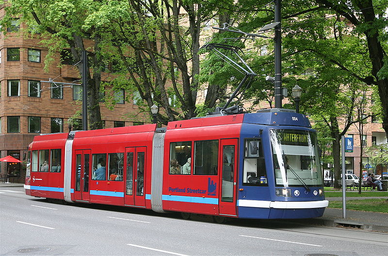
Based on similar federal funded streetcar programs in the USA (mainly Portland, OregonPortland Streetcar
The Portland Streetcar is a streetcar system in Portland, Oregon, that opened in 2001 and serves areas surrounding downtown Portland. It is currently a single line that is almost long and serves some 12,000 daily riders, but a second line is expected to open in 2012.As with the heavier-duty MAX...
) streetcars are rarely separated from other traffic and are not given traffic-signal priority over other vehicles (like Light rail
Light rail
Light rail or light rail transit is a form of urban rail public transportation that generally has a lower capacity and lower speed than heavy rail and metro systems, but higher capacity and higher speed than traditional street-running tram systems...
), except in a few situations to allow the rail cars—which cannot turn as sharply as other most motor vehicles—to make some turns. In Portland, using this "mixed traffic" operation has reduced the cost of constructing each segment and—by not closing traffic lanes permanently to other traffic, as is typically done with light rail—also minimized disruption to traffic flow, and allowed curbside parking to be retained, but also means slower operating speeds compared to light rail. Additional factors making the Portland Streetcar line less expensive to build per mile than light rail are that use of city streets largely eliminated the need to acquire private property for portions of the right-of-way, as has been necessary for the region's light rail lines, and that the vehicles' smaller size and therefore lighter weight has enabled the use of a "shallower track slab". The latter means that construction of the trackway necessitated excavating to a depth of only 12.2 inches (310 mm) instead of the conventional (for light rail) depth of around 18.3 inches (460 mm), significantly reducing the extent to which previously existing underground utilities had to be relocated to accommodate the trackway.
Vehicles
Each Portland streetcar is 66 feet (20.12 m) long, whereas light rail cars are typically 80 to 95 feet (24.38–28.96 m) long (Portland's Lightrail are between 80 and 95ft. long) and streetcars are operated as single cars at all times, never coupled into trains. The shorter cars keeps station construction expense lower than would be the case for a light-rail station, but the smaller cars do not provide equal carrying capacity as that of a light-rail train; a single articulated Portland streetcar is only about one-third the length of a two-car Lightrail Trains. It can be assumed the Minneapolis streetcars would follow similar design standards or acquire ex-Twin City Rapid Transit PCC streetcarPCC streetcar
The PCC streetcar design was first built in the United States in the 1930s. The design proved successful in its native country, and after World War II was licensed for use elsewhere in the world...
s from Newark City Subway. Click to view an example of the Portland streetcar vehicles Vehicle image one Vehicle image two
How to Ride
The streetcars would cost either as much as Hiawatha light rail ($1.75 non-rush hour, $2.25 rush hour) or slightly less due to slower travel speeds ($2.05 all day-like Portland). Discounted fares for disabled riders and veterans would also apply. Ticket boxes would be the same ones used at Hiawatha lightrail and Northstar Commuter Rail stations, and would accept day, event 6 hour, metro, U, college, and student passes, as well as super savers. Click to go to the Metro Transit website and learn more about these fares. Metro Transit websiteUse of Nextrip signs would also be used at the stations, to allow riders to determine the time of the next arriving train or bus at the station. The streetcars would be operated by Metro Transit
Metro Transit
There is more than one public transit system named Metro Transit. Some of the most significant include:* Metro Transit , serving Halifax Regional Municipality, Nova Scotia* Metro Transit , serving Kalamazoo, Michigan...
a division of the Metropolitan Council.
Lines
The current plans include seven lines, which with the exception of the Midtown GreenwayMidtown Greenway
The Midtown Greenway is a rail trail in Minneapolis, Minnesota. It is considered under segregated cycle facilities.Used both recreationally and for commuting, the partially below-grade Greenway runs east-west about one block north of Lake Street...
line follow former Twin City Rapid Transit
Twin City Rapid Transit
The Twin City Rapid Transit Company , also known as Twin City Lines , was a transportation company that operated streetcars, and buses in the Minneapolis-St. Paul metropolitan area in the U.S. state of Minnesota...
streetcar routes that were ripped up out of the ground in the early 1950s.
It appears as if the Central Line combined with the Nicollet Ave./Mall Line is the most promising line to be built, due to its importance in helping revitalize both North and South Minneapolis
Central Avenue Line
This line would run along Central Avenue NE (Minnesota State Highway 65Minnesota State Highway 65
Minnesota State Highway 65 is a highway in east-central and northeast Minnesota, which runs from its intersection with Washington Avenue at the north end of downtown Minneapolis and continues north to its northern terminus at its intersection with U.S...
) from the Nicollet Avenue/Mall Line in Downtown Minneapolis to the Columbia Heights Transit Center in Columbia Heights, Minnesota
Columbia Heights, Minnesota
As of the census of 2000, there were 18,520 people, 8,033 households, and 4,731 families residing in the city. The population density was 5,368.7 people per square mile . There were 8,151 housing units at an average density of 2,362.9 per square mile...
. The line would cross the Mississippi River
Mississippi River
The Mississippi River is the largest river system in North America. Flowing entirely in the United States, this river rises in western Minnesota and meanders slowly southwards for to the Mississippi River Delta at the Gulf of Mexico. With its many tributaries, the Mississippi's watershed drains...
via the Third Avenue Bridge
Third Avenue Bridge (Minneapolis)
The Third Avenue Bridge is a landmark structure of the city of Minneapolis, Minnesota, originally known as the St. Anthony Falls Bridge. It carries road traffic across the Mississippi River and right over the upper fringes of Saint Anthony Falls...
. There is an at-grade railroad crossing at 36th Avenue NE that would have to be altered to ensure steady traffic flow for the streetcars. Other than the railroad crossing, there are no major construction or engineering issues along the corridor.
The total length of the line would be 9.6 miles (15.4 km). The cost of track for the line would be approximately $100,000,000. Ridership estimates for the line are around 5,500 to 7,000 weekday riders.
Combined with the Nicollet Avenue/Nicollet Mall Line (current proposed action) the total length would be approximately 9.6 miles and a total combined cost of $185,000,000. Travel time from the I35W & 46th St. Bus Rapid Transit (BRT) Station to the Columbia Heights Transit Center would be approximately 35 minutes. Estimated ridership for the combination of the two lines would be 14,500-17,500 riders per weekday. Compared to the 30,500 riders per weekday on the 12.3 Mile Hiawatha Light Rail Line from Target Field
Target Field
Target Field is a baseball park located in downtown Minneapolis, Minnesota. It is the home ballpark of the Minnesota Twins, the city's Major League Baseball franchise. It is the franchise's sixth ballpark and third in Minnesota. The Twins moved to Target Field for the 2010 Major League Baseball...
in Downtown Minneapolis to Mall of America
Mall of America
The Mall of America, also called MOA and the Megamall, is a shopping mall located in Bloomington, Minnesota, a suburb of the Twin Cities, in the United States. It is located southeast of the junction of Interstate 494 and Minnesota State Highway 77, north of the Minnesota River and is across the...
.
The route follows the northern leg of TCRT's Bloomington–Columbia Heights line.
Nicollet Avenue/Mall Line
This line would run along Nicollet AvenueNicollet Avenue
Nicollet Avenue is a major street in Minneapolis, Minnesota, and three of its suburbs. It passes through a number of locally well-known neighborhoods and districts, notably Eat Street in south Minneapolis and the traffic-restricted Nicollet Mall in the city's downtown.It began as a military road...
and Nicollet Mall
Nicollet Mall
Nicollet Mall is a portion of Nicollet Avenue running through downtown Minneapolis, Minnesota, United States. Working as a pedestrian and transit mall, it is also an upscale shopping and dining district...
from 46th Street South through Downtown Minneapolis (connecting to the Hiawatha Line
Hiawatha Line
The Hiawatha Line is a light rail corridor in Hennepin County, Minnesota that extends from downtown Minneapolis to the southern suburb of Bloomington. It was formerly known as the Hiawatha Line named after Hiawatha Avenue. Major connections on the line include the Minneapolis-St...
at Nicollet Mall Station) to the Central Avenue Line.
The line would be 4.1 miles long. The track would cost approximately $85,000,000. Ridership estimates for the line are approximately 10,000 to 12,000 weekday riders.
Combined with the Central Avenue Line (current proposed action) the total length would be approximately 9.6 miles and a total combined cost of $185,000,000. Travel time from the I35W & 46th St. Bus Rapid Transit (BRT) Station to the Columbia Heights Transit Center would be approximately 35 minutes. Estimated ridership for the combination of the two lines would be 14,500-17,500 riders per weekday. Compared to the 30,500 riders per weekday on the 12.3 Mile Hiawatha Light Rail Line from Target Field
Target Field
Target Field is a baseball park located in downtown Minneapolis, Minnesota. It is the home ballpark of the Minnesota Twins, the city's Major League Baseball franchise. It is the franchise's sixth ballpark and third in Minnesota. The Twins moved to Target Field for the 2010 Major League Baseball...
in Downtown Minneapolis to Mall of America
Mall of America
The Mall of America, also called MOA and the Megamall, is a shopping mall located in Bloomington, Minnesota, a suburb of the Twin Cities, in the United States. It is located southeast of the junction of Interstate 494 and Minnesota State Highway 77, north of the Minnesota River and is across the...
.
The route follows the southern leg of TCRT's Nicollet–Northwest line.
Midtown Greenway/Lake Street Line
This line would run along Lake Street between St. Louis Park & Hiawatha Avenue, connecting the future proposed Southwest LRT Line, Hiawatha LRT Line, and several major housing sites together.Although TCRT streetcars never ran along the rail corridor that is now the Midtown Greenway
Midtown Greenway
The Midtown Greenway is a rail trail in Minneapolis, Minnesota. It is considered under segregated cycle facilities.Used both recreationally and for commuting, the partially below-grade Greenway runs east-west about one block north of Lake Street...
, the Minneapolis leg of the Selby-Lake line ran one block south on Lake Street.
University/4th Street Line
This line would run from downtown along Hennepin Avenue to University Avenue, continuing east to Oak Street. The route follows the northern leg of TCRT's Oak–Harriet line.Broadway/Washington Avenue Line
This line would run along West Broadway (Hennepin County Road 81) and Washington AvenueWashington Avenue (Minneapolis)
Washington Avenue is a major thoroughfare in Minneapolis, Minnesota. Starting north of Lowry Avenue, the street runs straight south, with Interstate 94 running alongside it until just south of West Broadway, when the freeway turns to the west...
from the Robbinsdale Transit Center to ether Nicollet Mall
Nicollet Mall
Nicollet Mall is a portion of Nicollet Avenue running through downtown Minneapolis, Minnesota, United States. Working as a pedestrian and transit mall, it is also an upscale shopping and dining district...
and 5th Street or Park Avenue and 5th Street in Downtown Minneapolis, depending on the final configuration.
The line would be 11.4 miles long. The track would cost approximately $135,000,000. Estimated ridership for the line would be approximately 4,500 to 5,500 weekday riders.
The route follows TCRT's 28th Ave.–Robbinsdale line.
Hennepin Avenue Line
This line line would run mostly along Hennepin AvenueHennepin Avenue
Hennepin Avenue is a major street in Minneapolis, Minnesota, United States. It runs from Lakewood Cemetery , north through the Uptown District of Southwest Minneapolis, through the former "Bottleneck" area west of Loring Park, through the North Loop in the city center, to Northeast Minneapolis and...
from the Uptown Transit Center through Downtown Minneapolis (connecting with the Hiawatha Line
Hiawatha Line
The Hiawatha Line is a light rail corridor in Hennepin County, Minnesota that extends from downtown Minneapolis to the southern suburb of Bloomington. It was formerly known as the Hiawatha Line named after Hiawatha Avenue. Major connections on the line include the Minneapolis-St...
at Warehouse District / Hennepin Avenue Station) to the University of Minnesota
University of Minnesota
The University of Minnesota, Twin Cities is a public research university located in Minneapolis and St. Paul, Minnesota, United States. It is the oldest and largest part of the University of Minnesota system and has the fourth-largest main campus student body in the United States, with 52,557...
's East Bank, at which point it would become the University/4th Street Line. The line would cross the Mississippi River
Mississippi River
The Mississippi River is the largest river system in North America. Flowing entirely in the United States, this river rises in western Minnesota and meanders slowly southwards for to the Mississippi River Delta at the Gulf of Mexico. With its many tributaries, the Mississippi's watershed drains...
on the Hennepin Avenue Bridge
Hennepin Avenue Bridge
The Hennepin Avenue Bridge is the structure that carries Hennepin County State Aid Highway 52, Hennepin Avenue, across the Mississippi River in Minneapolis, Minnesota at Nicollet Island. Officially, it is the Father Louis Hennepin Bridge, in honor of the 17th-century explorer Louis Hennepin, who...
.
The line would be 3.9 miles long. The track would cost approximately $80,000,000. Ridership estimates for the line are approximately 9,500 to 12,000 weekday riders. (This includes the University/4th Street Line also.)
The route follows a portion of the southern leg of TCRT's Oak–Harriet line.
Chicago Avenue Line
This line would run along Chicago Avenue from 38th Street South to Nicollet MallNicollet Mall
Nicollet Mall is a portion of Nicollet Avenue running through downtown Minneapolis, Minnesota, United States. Working as a pedestrian and transit mall, it is also an upscale shopping and dining district...
in Downtown Minneapolis via 9th and 10th streets. The line would then run along Nicollet Mall
Nicollet Mall
Nicollet Mall is a portion of Nicollet Avenue running through downtown Minneapolis, Minnesota, United States. Working as a pedestrian and transit mall, it is also an upscale shopping and dining district...
to 5th Street. It would terminate at Nicollet Mall Station on the Hiawatha Line
Hiawatha Line
The Hiawatha Line is a light rail corridor in Hennepin County, Minnesota that extends from downtown Minneapolis to the southern suburb of Bloomington. It was formerly known as the Hiawatha Line named after Hiawatha Avenue. Major connections on the line include the Minneapolis-St...
.
The line would be 3 miles (4.8 km) long. The cost of track for the line would be approximately $80,000,000. Ridership estimates for this line are approximately 11,000 to 13,000 riders on weekdays.
The route follows the southern leg of TCRT's Chicago–Penn line.