
Mineral River
Encyclopedia
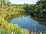
The Mineral River is a short tributary
of Lake Superior
on the western Upper Peninsula of Michigan
in the United States
. It flows for its entire length in western Ontonagon County
, rising in the Ottawa National Forest
and flowing generally northward to meet Lake Superior about 11 mi (18 km) west-southwest of Ontonagon
. The United States Board on Geographic Names
settled on "Mineral River" as the stream's name in 1976; according to the Geographic Names Information System
it has also been known historically as "Beaver Creek."
Tributary
A tributary or affluent is a stream or river that flows into a main stem river or a lake. A tributary does not flow directly into a sea or ocean...
of Lake Superior
Lake Superior
Lake Superior is the largest of the five traditionally-demarcated Great Lakes of North America. It is bounded to the north by the Canadian province of Ontario and the U.S. state of Minnesota, and to the south by the U.S. states of Wisconsin and Michigan. It is the largest freshwater lake in the...
on the western Upper Peninsula of Michigan
Michigan
Michigan is a U.S. state located in the Great Lakes Region of the United States of America. The name Michigan is the French form of the Ojibwa word mishigamaa, meaning "large water" or "large lake"....
in the United States
United States
The United States of America is a federal constitutional republic comprising fifty states and a federal district...
. It flows for its entire length in western Ontonagon County
Ontonagon County, Michigan
-National protected areas:* Keweenaw National Historical Park * Ottawa National Forest -Demographics:As of the census of 2000, there were 7,818 people, 3,456 households, and 2,225 families residing in the county. The population density was 6 people per square mile . There were 5,404 housing units...
, rising in the Ottawa National Forest
Ottawa National Forest
The Ottawa National Forest is a 1.0 million acre national forest in the Upper Peninsula of the U.S. state of Michigan. It includes much of Gogebic and Ontonagon counties, as well as slices of Iron, Houghton, Baraga, and Marquette counties. The forest is under the jurisdiction of the U.S...
and flowing generally northward to meet Lake Superior about 11 mi (18 km) west-southwest of Ontonagon
Ontonagon, Michigan
Ontonagon is a village in the U.S. state of Michigan. As of the 2000 census, the village had a total population of 1,769. It is the county seat of Ontonagon County....
. The United States Board on Geographic Names
United States Board on Geographic Names
The United States Board on Geographic Names is a United States federal body whose purpose is to establish and maintain uniform usage of geographic names throughout the U.S. government.-Overview:...
settled on "Mineral River" as the stream's name in 1976; according to the Geographic Names Information System
Geographic Names Information System
The Geographic Names Information System is a database that contains name and locative information about more than two million physical and cultural features located throughout the United States of America and its territories. It is a type of gazetteer...
it has also been known historically as "Beaver Creek."